
By Vasanthi Pendakur
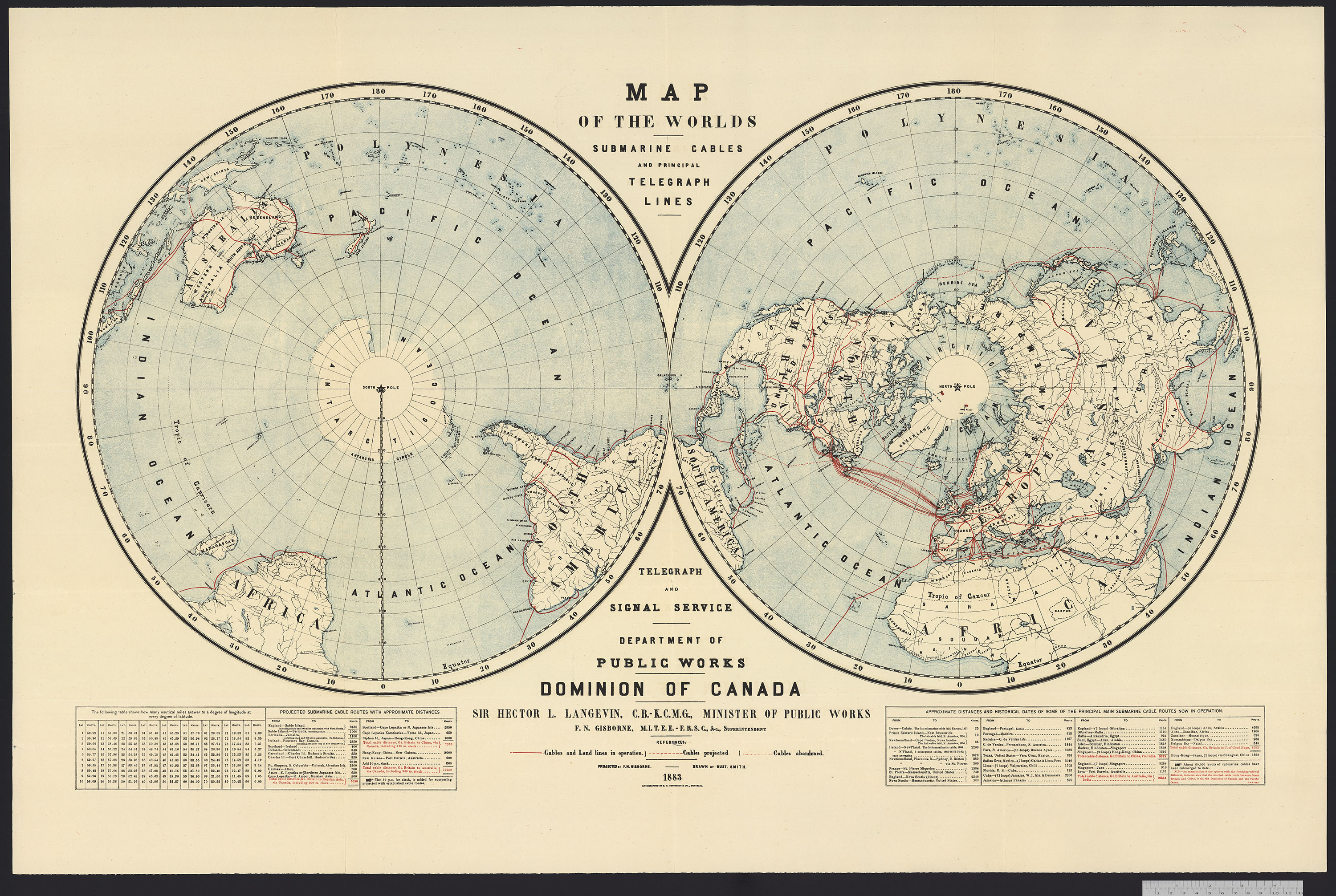
Polar projections showing submarine cables and principal telegraph lines, 1883. Lines are shown in red. (e011211770)
Much of the world’s internet is still underwater. Despite satellite communications, despite wireless technology, the base connections for the internet are still undersea cables. Long cables crisscross the oceans and the continents to transmit the signals that bring internet to our devices. Telecommunication companies laid most of the existing cables, but recently tech giants have been building their own lines.
Undersea cables are expensive to build, and slow to plan, but they are still cheaper than satellites. Planning the laying of cables takes time. Routes are charted to avoid obstacles, tidal patterns, unstable formations and, for the actual laying, inclement weather. The cables are made on special machines that maintain tension. Building starts with a small wire, which is then wrapped in layers of copper, plastic, steel or tar for protection. The cables must be able to withstand damage from earthquakes, ships, and sea life. Sharks eating the internet is known to happen… and ships can accidentally cut cables.
Cables are then slowly loaded onto specially made ships; precautions are taken to ensure cables do not kink. Cables are then slowly laid down along the cable route. It can take weeks to lay a full length of cable properly, especially if there is bad weather.
The first experiments with submarine cables took place in the 1850s. Inventors, including Samuel Morse and Charles Wheatstone (pioneers in the invention of the electric telegraph), and Michael Faraday (a pioneer in the field of electromagnetism), were experimenting to find the best way of submerging wires (or cables) onto the seabed.
A formula of copper wires encased in layers of iron, india rubber, and gutta-percha (sap that served as thermoplastic insulation) was determined to be the best method. Confident in their experiments, Morse, Cyrus West Field, a financier, and Matthew Maury, an oceanographer, joined together to form the Atlantic Telegraph Company, with the goal of ordering and laying a cable across the Atlantic ocean. A test involving laying cables from Nova Scotia to Newfoundland in 1856 was successful.
The next attempt was the longer cable across the Atlantic, from Telegraph Field, Ireland, to Heart’s Content, Newfoundland. Problems with storms and breaking cables delayed the project, but the cable was finally connected in August 1858. An official message from Queen Victoria congratulating the company took 16 hours to arrive, but that still vastly reduced the delivery time in that period: ten days on a ship. The cable broke three weeks later, probably from improper handling and storage. A cable was successfully laid in 1866 by the SS Great Eastern.
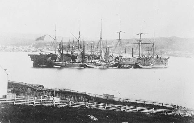
SS Great Eastern completing the laying of the second transatlantic telegraph cable, 1866. (c004484)

Cover of a souvenir book depicting an 1894 cable expedition. (e004414208)
Many more cable expeditions followed, and the success of the 1866 expeditions led to the production of souvenir items depicting these events. LAC holds examples of this type of art in the Henry Ash Collection. Henry Ash was an amateur artist as well as a draftsman and designer from London, England, who also served as a general engineer assistant for the crew of the CS Faraday on occasion. He produced numerous pencil sketches of the voyages he took part in, some of which were turned into the souvenir book above. LAC holds Ash’s artwork from some of his expeditions.
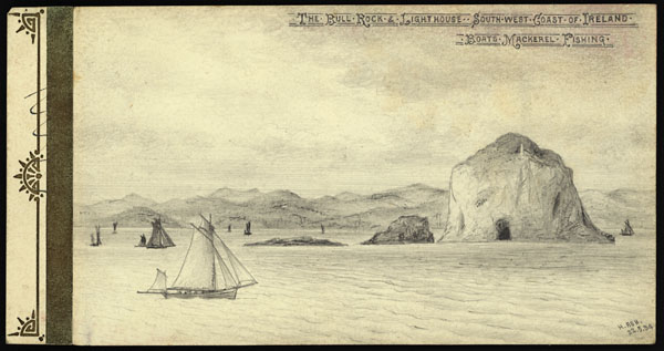
View of the coast of Ireland at the start of the expedition. (e004414185)
Ash’s sketches are well shaded, detailed, and precisely labelled with the location and expedition. The landscape along the ocean coastline is shown in detailed greyscale. His drawings depict roads, coastlines, and the deep sea throughout the voyage, often showing the ship in the middle of the sea, surrounded by natural features. Ash turned his sketches from a later expedition into a souvenir book for the public. LAC’s collection shows the early history of the internet, as well as a process (cable laying) that, while lower-tech, is not much changed today.
Visit the Flickr album for more images of Henry Ash’s sketches.
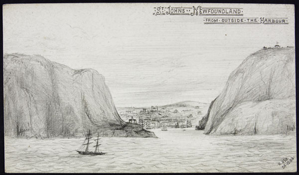
View of the entrance to St. John’s Harbour. (e004414154)
Other resources:
Submarine communications cable
How the Internet Travels Across Oceans
History of the Atlantic Cable & Undersea Communications
Vasanthi Pendakur is a project manager in the Online Content team at Library and Archives Canada.

Hello Vasanthi,
Thanks very much for your blog entry. Quite interesting. This reminded me that some time ago Guy Tessier, photo archivist, acquired photographs by the Montreal photographer Charles Dion — including some of the earliest stereo photos at LAC. the Mikan fonds level entry reads:
Le fonds comprend: Vues stéréoscopiques au Montréal incluant de l’Église Saint-Jacques, de l’édifice des douanes, du Palais de Justice, du village de Richelieu, du Fort Chambly, de l’American House, d’une excursion champêtre dans les îles de Boucherville, Place d’Armes le jour de l’Illumination, Chapelle du Couvent des Soeurs Grises, Collège McGill, Résidence de Simon McTavish, statues d’un jardin privé (possiblement des joailliers Savage & Lyman), marché Bonsecours, Église Notre-Dame, Banque de Montréal, vue du Champs de Mars, Bureau de poste, pont Victoria en construction, bateaux dans le port de Montréal, rue St-Jacques, rue Notre-Dame, St. Lawrence Hall, Villa Yule – ancien Manoir de Salaberry, séries de cinq études photographiques; présentation d’un plateau d’argent fabriqué par les joailliers Savage & Lyman de Montréal; vue du magasin Savage & Lyman sur Notre-Dame. Photos par Charles Dion (1833-1867). Série de vues stéréoscopiques prises très tôt; 11 cartes portent l’inscription ” dame Éliza Paré – Charles Dion” et sont signées par Charles Dion.
I think the Mikan number is 202194; the accession number was 1996-479 DAP.
Amongst the images is one (I think either near McGill or the Place D’Armes –but my memory may be faulty) which includes a poster on a post which (under magnification) I believe makes mention of the Atlantic Cable.
I thought you might be interested.
Andrew Rodger
Thank you. I’m glad you enjoyed it. That’s a really cool find. It fits well with the promotion of the event. I’ll have to check it out.
Pingback: Henry Ash and why internet connections are still underwater — Library and Archives Canada Blog | Ups Downs Family History
Pingback: Library and Archives Canada Blog – Featured Blogger of the Week November 12, 2021 | Ups Downs Family History