Summiting Mount Logan in 1925: Fred Lambart’s personal account of the treacherous climb and descent of the highest peak in Canada – A Co-Lab Challenge

By Jill Delaney

When Howard “Fred” Lambart’s (1880–1946) painful, frozen feet finally touched solid ground again on July 4, 1925, he thought he would feel elated. After all, it had been 44 days since he and his fellow mountaineers had made contact with anything other than snow and ice on their ascent of Mount Logan, Canada’s highest peak (5,959 m). The expedition had exhausted them all, and Lambart could only manage a sense of relief at having made it this far. There were still 140 kilometres of hard travel to go before they reached the town of McCarthy, Alaska.

A sepia coloured photograph of a group of men with Mount Logan in the background.

Photograph of the party taken by Captain Hubrick at McCarthy, Alaska. From left to right: N.H. Read, Alan Carpe, W.W. Foster, A.H. MacCarthy, H.S. Hall, Andy Taylor, R.M. Morgan, Howard “Fred” Lambart (e011313489_s1).

Lambart was part of a team of eight climbers assembled by the Alpine Club of Canada and the American Alpine Club in 1925 to tackle Mount Logan, located in the remote southwestern corner of Yukon Territory, in what is now Kluane National Park and Reserve. The mountain is in the Tachal Region of the Kluane First Nation’s traditional territory, “A Si Keyi.” The Lu’an Mun Ku Dan (Kluane Lake People) and the Champagne and Aishihik peoples have lived there for generations.

Most Lu’an Mun Ku Dan, Champagne and Aishihik First Nations people identify themselves as descendants of the Southern Tutchone. Others came from nations such as the Tlingit, the Upper Tanana and the Northern Tutchone. In the Southern Tutchone language, the indigenous peoples of this region are known as “the people who live beside the tallest mountains.”

Lambart had climbed many of the peaks surrounding Mount Logan as a surveyor for the Geodetic Survey of Canada. As part of this work, he had conducted photo-topographic work on the Yukon–Alaska border in 1912–1913.

No European settler had yet attempted to conquer the behemoth that is Mount Logan, the most massive mountain in the world. It was and still is a remote sub-arctic mountain, with notoriously terrible weather due to its proximity to the west coast. The 1925 climbing team, made up of Lead Captain A.H. MacCarthy, Assistant Lead Fred Lambart, Alan Carpe, H.S. Hall, N.H. Read, R.M. Morgan, Andy Taylor and W.W. Foster, hiked 1,025 km in 63 days. They carried packs of up to 38 kilograms for most of this time, and climbed a total of 24,292 metres, or more than four times the elevation of the mountain, in order to transport their supplies up the mountain themselves. Thanks to the Lambart Family Fonds at Library and Archives Canada (LAC), containing both Lambart’s personal diary and over 200 photographs taken during the expedition, we have a detailed and intimate account of the thrills and extreme hardships of this remarkable climb. Alan Carpe also created a documentary film, The Conquest of Mount Logan. It is a fitting time to revisit the event, with the recent completion of the first of two ascents in 2021–2022 by Dr. Zac Robinson, Dr. Alison Criscitiello, Toby Harper-Merrett and Rebecca Haspel, from the Alpine Club of Canada and the University of Alberta. Using photographs from the 1925 expedition, they are conducting a repeat photography project, as well as an ice-coring project, to better understand climate and change.

Fred Lambart came from an upper-middle-class British-Canadian family, and graduated from McGill University with a bachelor’s degree in science. He initially worked on surveys for the Grand Trunk Pacific Railway, before becoming a Dominion Land Surveyor in 1905. His daughter Evelyn would go on to an illustrious career as a filmmaker at the NFB. His daughter Hyacinthe was an early female Canadian pilot. Tragically, his two sons, Edward and Arthur, were killed during the Second World War.

The 1925 Mount Logan expedition came during a period of very active mountaineering, when Europeans saw “conquering” summits as moments of national, colonial and imperial prestige. Several attempts to summit Mount Everest were made during this time. In 1897, the Italian alpinist the Duke of Abruzzi (reportedly having his packers carry his brass bed up the mountain for him) summited Mount St. Elias, the second-highest peak in the Canadian northwest. Lambart himself was recorded as the first European to summit Mount Natazhat (4,095 m), in 1913.

Preparations for the 1925 Mount Logan expedition began in 1922. They included fundraising and the selection of the team. All agreed that A.H. MacCarthy should lead, with Lambart named as assistant. MacCarthy scouted three different routes in the years leading up to the official expedition, returning to the mountain again in February 1925 to cache 8,600 kilograms of supplies in advance, at various points along the route.

Photograph of Mount Logan with the names of the peaks and routes annotated.

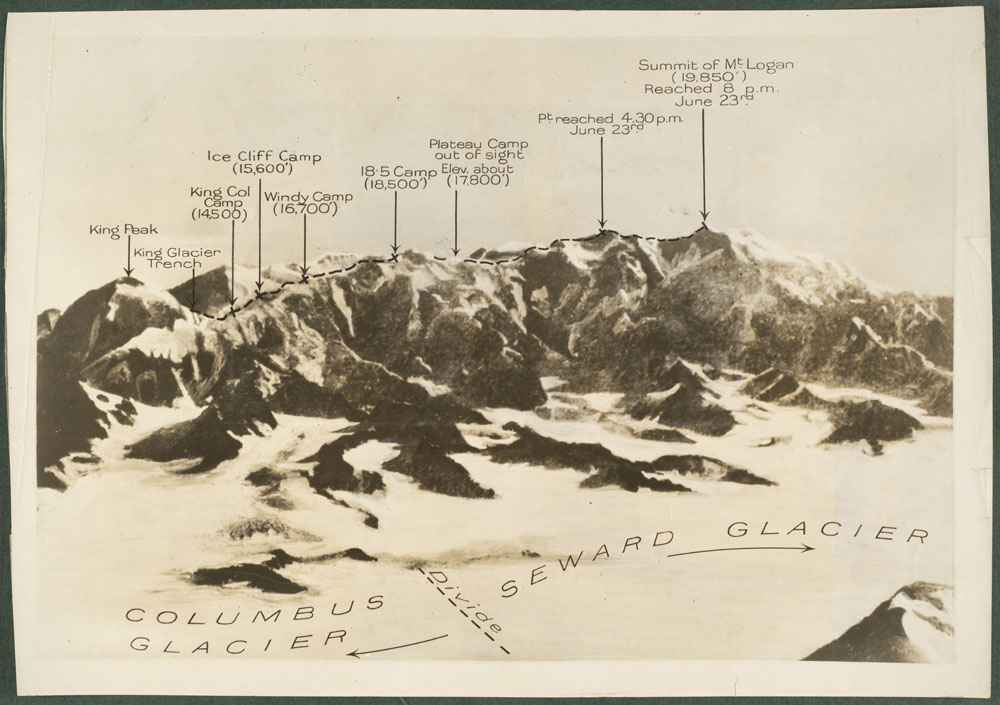
Annotated photograph showing the route of the 1925 expedition (e011313492).

The team leaves McCarthy, Alaska, on May 12 and begins its climb on May 18. Much of the ascent is taken up with grinding slogs by the team members (they have no packers once they step foot onto the mountain) relaying their supplies up and down the glaciers to their various camps. Nevertheless, the alpinists do find moments to note the incredible beauty of their surroundings. On June 6, Lambart writes, “the early morning lighting on the mountains and lakes on the day developing into one of perfect clearness was a vision not to be forgotten.”

By June 11, while camping at King Col (5,090 m), the climbers’ exertion is beginning to show, along with signs of elevation sickness amongst a few of the members. Lambart reports shortness of breath, and Morgan and Carpe both vomit during the night, while MacCarthy’s eyes begin to suffer. “If Mac doesn’t let up there are a few that will not get through who otherwise could have done so,” writes Lambart. Discussions are held to try to convince MacCarthy to slow the pace.

The food supply begins to be something of an obsession, with Lambart’s calculations taking up more and more space on the pages of his diary. Lambart also notes that they plan to leave King Col the next day to try to make it to the summit and back in four days.

A photograph of Mount Logan with four climbers in the foreground.

Team members working a way up through the ice wall above King Col, King Peak towering above (e011313500_s1).

In reality, it takes another 10 days of exhausting climbing with snowshoes and crampons before they finally summit on June 23. The team begins to use ropes to keep team members safe as they tackle bad weather, steep climbs across icefalls, extreme cold and constant fatigue. Morgan, accompanied by Hall, turns back due to poor health. The remaining six continue to push upward, not knowing what lies ahead. While ascending what they think is the summit, Logan wrote the following:

[…] we saw straight off east about 3 miles the real summit of Logan which up to this time, I don’t think any of us had seen before. This was our goal, it was now 4:30 and the weather was holding.

A bit of up and down and a few switchbacks up the final steep, icy slopes—and, finally…

[…] we are on the top of the highest point in the Dominion of Canada. […] We all congratulated Mac and shook hands. […] Carpe ran the Bell and Howell a few seconds, Read took some snaps, but we were reminded by Andy that there was a storm brewing […]

Just 25 minutes is spent savouring their achievement. Almost immediately, the weather begins to close in around them, and the temperature drops rapidly. The sunshine they had enjoyed at the peak disappears as a heavy fog moves in, completely hiding any signs of the trail leading back to their camp. “We are in real peril,” Lambart later notes in his diary. Conditions are deteriorating so rapidly they decide to bivouac on a patch of steep hard snow, where they “were all burrowing like a bunch of rabbits,” to create shelters for the night. Lambart shares a burrow with Read, and gives his heavy coat to Taylor, who is on his own in another burrow. Much to his later misfortune, Lambart overcompensates with four pairs of socks in his boots, restricting the circulation to his toes. He wakes in the middle of the night to try to stamp some feeling back into them, but he will suffer from this miscalculation for the remainder of the expedition and beyond. Several of his toes were amputated later in life.

Photograph of two people standing side by side looking away from the camera.

Two members of the expedition looking out from King Ridge (e011313497_s2).

Although the mountain top remains shrouded in fog the next morning, they have no real choice but to continue in order to locate the trail to find their way back. In the process, both Taylor and Mac walk off cliffs they cannot see, falling several metres each, but without serious injury. Eventually they locate one of the willow poles they had placed every 150 feet as markers on the way up. Nevertheless, the ordeal is not over. The first rope becomes confused and marches in the wrong direction at one point, leaving them several hours behind the others in returning to camp. Lambart begins to hallucinate:

My glasses were dark and the scene ahead was of two figures constantly silhouetted against a dead whiteness where ground and sky was one. A strange imagination possessed me all the while that I could not drive away, namely, the presence of fences and fields and farms with habitations to right and left of us.

A much deserved day of rest follows, but they are back on the trail the day after, which Lambart finds to be “one of the most [difficult] tests of endurance and suffering of the whole trip.” MacCarthy’s obituary for Lambart later revealed that, on what is likely this same day (June 26), Lambart became exhausted in another bout of severe weather, and collapsed face down on their descent to the high-level campsite (5,640 m). He begged MacCarthy to leave him in order to save the others, “a murderous proposal” in MacCarthy’s mind, and Taylor supported him until they stumbled back to camp. Lambart remembers nothing of this.

The remainder of the descent goes relatively smoothly, with the temperature and the weather improving most days, and with the climbers having less equipment and supplies to carry. Additional days of rest are taken from time to time. The team begins abandoning supplies along the route, including Read’s diary, which is never retrieved. On July 1, the first signs of life are joyfully spotted—a bird at Cascade camp and bumble bees and flies at the Advance Base Camp below.

On July 4, their feet finally touch land again. Their relief is quickly dampened by the realization that bears had destroyed not just one, but two, caches of food the team had stowed for their return. Luckily, the next day, they find food that had been left hanging in a tree for them by a colleague. They celebrate that evening, but the next day are back hard at work, constructing rafts to carry them down the Chitina River in order to shorten their trek into town. The raft in which Lambart, Taylor and Read are travelling quickly transports them 72 km downstream to a meadow, from which they begin the final long hike of their journey. The raft conveying MacCarthy, Carpe and Foster follows, but “shot by us in a wider and better channel to our left. Mac held up his hand triumphantly as they went by. This was the last we saw of them.” Lambart, Taylor and Read arrive back in town late at night on July 12, racing each other the last few kilometres in their haste to arrive (in spite of Lambart’s very painful feet). There is no sign of the MacCarthy raft for several worrying days. MacCarthy, Carpe and Foster are finally located on July 15, having overshot their mark, tipped their raft and walked back toward McCarthy until they happened upon a road crew.

Lambart called the expedition “one of the strangest ventures of my life.” The men returned to their homes to much acclaim and publicity, with The New York Times naming Lambart one of the world’s greatest climbers. They wrote their report and printed their photos. Carpe developed and edited his motion picture, to be shown to appreciative audiences in the comfort of heated movie theatres and plush seats.

It would be 25 years before another team would attempt to climb Mount Logan. Today, climbers can fly onto one of the glaciers to avoid the long trek to the base of the massif. It is nevertheless considered to be one of the most challenging climbs in the world.

Our latest Co-Lab challenge allows users to tag images and transcribe entries from Lambart’s diary!

Other LAC resources:


This blog was written by Jill Delaney, Lead Archivist, Photography, in the Specialized Media Section of the Private Archives Division at Library and Archives Canada. Assistance was provided by Angela Code of the Listen Hear our Voices initiative.

Mountains of Blackflies

By Martha Sellens

One of my favourite parts of being an archivist is solving archival mysteries, especially when they result in something unexpected. One of my recent mysteries took me from a piece of artwork to blackflies—and I’m not talking about an unexpected (and unwanted!) visitor in the Library and Archives Canada (LAC) archival vault.

It all started with a couple of prints from the Geological Survey of Canada. I was working on improving their description in our database so that people could find them. (These are the improved descriptions for item 5067117 and item 5067118.) The prints were from 1883 and had been acquired by the archives so long ago—before 1925!—that there wasn’t much information about them in our records.

So I started digging. The prints were panoramas, nearly an arm-span wide and as tall as a trade paperback book. Both were prints of the same drawing showing the view of the Notre-Dame or Shickshock (now known as Chic-Chocs) Mountains in Quebec’s Gaspé Peninsula. To make things easier, they also had a title, artist and printing house included in the print image, so I was immediately able to link it back to A.P. Low’s report on his 1883 expedition for the Geological Survey.

Black and white print of a drawing depicting a series of rounded mountains. There are trees and grass in the foreground. The print is titled and has some small labels along the top edge indicating cardinal directions.

Panoramic photolithographic print of the Notre-Dame or Chic-Chocs (Shickshock) Mountains in Gaspé Peninsula, Quebec. Drawn by L. Lambe from a sketch by A.P. Low, to accompany A.P. Low’s 1883 report to the Geological Survey of Canada. The prints in LAC’s collection (R214-2887-9) are not yet digitized. Image courtesy of NRCan (GEOSCAN).

A.P. Low led a small team of surveyors into the interior of the Gaspé Peninsula in the summer of 1883 to examine the geology of the area, as well as to create and improve maps of the region. The Geological Survey of Canada was often one of the first groups of surveyors in an area and they quickly realized that they couldn’t document geological features without creating maps as well. Low’s report describes some of their day-to-day tasks as well as their scientific findings. It was published as part of an 800-page volume with all of the Geological Survey field reports from 1882–84. You can download a digitized version from the Natural Resources Canada website or consult the physical book in LAC’s library holdings.

LAC also holds many of the field books from these surveys. These are the notebooks the surveyors used in the field to keep track of their daily findings. With my curiosity piqued, I ordered in A.P. Low’s notebooks to take a look. I’m not a geologist so I wasn’t sure if I would be able to understand his notes, but that’s half the fun! Most of the notebooks were filled with numbers and quick sketches, but in the back of one, I hit the jackpot.

Most people expect government records to be bureaucratic and boring—and many of our records live down to these expectations—but it’s so exciting when you find something that proves that even the work lives of nineteenth-century public servants could be funny and interesting.

In the back of one of A.P. Low’s field books, I found the pencil sketch he drew of the Chic-Chocs (Shickshock) Mountains. The very one that they used to create the final drawing that accompanied his report and in the prints that started my current investigation. It’s a fairly simple pencil drawing, spread over two lined pages in the back of the book, but the shading and the line work starts to trail off somewhere in the middle.

Why did he stop? Fortunately for us, he wrote down the reason: “Unable to finish on account of the Black Flies!” His comment is accompanied by a suspicious smudge and three little blackflies doodled near the description of his sketch.

Photograph of a red leather notebook, open on page 98. The pages are lined and there is a pencil drawing of some mountains and three small flies. A note at the bottom reads, “Sketch of some of the Mountains seen from Mount Albert looking North.” To the right another note reads, “Unable to finish on account of the Black Flies.”

Sketch of the Chic-Chocs (Shickshock) Mountains on page 98 of A.P. Low’s field book #2276, Gaspé Peninsula, Quebec. Geological Survey of Canada (RG45 Vol 142). Photo by Martha Sellens.

I can just picture the surveyors baking in the June sun on the top of a Quebec mountain and cursing one of Canada’s most annoying predators. It can be easy to forget that behind every record—even the bureaucratic and boring ones—are the people that worked together to create it. This notebook, and the more formal prints that led me there, is a great reminder of the people—and blackflies—behind the records.

Other LAC related resources:


Martha Sellens is an archivist for the natural resources portfolio in the Government Archives Division at Library and Archives Canada.

Henry Ash and why internet connections are still underwater

By Vasanthi Pendakur

North and south map of the world showing telegraph lines across the Atlantic and overland.

Polar projections showing submarine cables and principal telegraph lines, 1883. Lines are shown in red. (e011211770)

Much of the world’s internet is still underwater. Despite satellite communications, despite wireless technology, the base connections for the internet are still undersea cables. Long cables crisscross the oceans and the continents to transmit the signals that bring internet to our devices. Telecommunication companies laid most of the existing cables, but recently tech giants have been building their own lines.

Undersea cables are expensive to build, and slow to plan, but they are still cheaper than satellites. Planning the laying of cables takes time. Routes are charted to avoid obstacles, tidal patterns, unstable formations and, for the actual laying, inclement weather. The cables are made on special machines that maintain tension. Building starts with a small wire, which is then wrapped in layers of copper, plastic, steel or tar for protection. The cables must be able to withstand damage from earthquakes, ships, and sea life. Sharks eating the internet is known to happen… and ships can accidentally cut cables.

Cables are then slowly loaded onto specially made ships; precautions are taken to ensure cables do not kink. Cables are then slowly laid down along the cable route. It can take weeks to lay a full length of cable properly, especially if there is bad weather.

The first experiments with submarine cables took place in the 1850s. Inventors, including Samuel Morse and Charles Wheatstone (pioneers in the invention of the electric telegraph), and Michael Faraday (a pioneer in the field of electromagnetism), were experimenting to find the best way of submerging wires (or cables) onto the seabed.

A formula of copper wires encased in layers of iron, india rubber, and gutta-percha (sap that served as thermoplastic insulation) was determined to be the best method. Confident in their experiments, Morse, Cyrus West Field, a financier, and Matthew Maury, an oceanographer, joined together to form the Atlantic Telegraph Company, with the goal of ordering and laying a cable across the Atlantic ocean. A test involving laying cables from Nova Scotia to Newfoundland in 1856 was successful.

The next attempt was the longer cable across the Atlantic, from Telegraph Field, Ireland, to Heart’s Content, Newfoundland. Problems with storms and breaking cables delayed the project, but the cable was finally connected in August 1858. An official message from Queen Victoria congratulating the company took 16 hours to arrive, but that still vastly reduced the delivery time in that period: ten days on a ship. The cable broke three weeks later, probably from improper handling and storage. A cable was successfully laid in 1866 by the SS Great Eastern.

Large ship seen from shore.

SS Great Eastern completing the laying of the second transatlantic telegraph cable, 1866. (c004484)

Cover of a souvenir book of the 1894 Mackay-Bennett Atlantic Cable.

Cover of a souvenir book depicting an 1894 cable expedition. (e004414208)

Many more cable expeditions followed, and the success of the 1866 expeditions led to the production of souvenir items depicting these events. LAC holds examples of this type of art in the Henry Ash Collection. Henry Ash was an amateur artist as well as a draftsman and designer from London, England, who also served as a general engineer assistant for the crew of the CS Faraday on occasion. He produced numerous pencil sketches of the voyages he took part in, some of which were turned into the souvenir book above. LAC holds Ash’s artwork from some of his expeditions.

Sketch of Bull Rock and Bull Rock Lighthouse, located off the southwest coast of Ireland, with boats fishing for mackerel.

View of the coast of Ireland at the start of the expedition. (e004414185)

Ash’s sketches are well shaded, detailed, and precisely labelled with the location and expedition. The landscape along the ocean coastline is shown in detailed greyscale. His drawings depict roads, coastlines, and the deep sea throughout the voyage, often showing the ship in the middle of the sea, surrounded by natural features. Ash turned his sketches from a later expedition into a souvenir book for the public. LAC’s collection shows the early history of the internet, as well as a process (cable laying) that, while lower-tech, is not much changed today.

Visit the Flickr album for more images of Henry Ash’s sketches.

Sketch of the entrance to St. John’s Harbour.

View of the entrance to St. John’s Harbour. (e004414154)

Other resources:

Submarine communications cable

How the Internet Travels Across Oceans

History of the Atlantic Cable & Undersea Communications


Vasanthi Pendakur is a project manager in the Online Content team at Library and Archives Canada.

Images of Icebergs now on Flickr 

National Film Board photographers setting up by an iceberg (e011175885)

Icebergs are large pieces of ice that break off glaciers and float into the surrounding ocean. They can be pure white or streaked with blue and brown. Blue streaks come from melt water freezing in the cracks of the original glaciers. Brown streaks come from dust landing on the ice or erosion from the original glacier scraping the ground.

Iceberg in Hudson Strait (a045191)

The shape and size of icebergs depends on their breakage and melt patterns, as well as waves, temperature, and the ice pack around them. Common shapes include tabular, blocky, wedge, pinnacle, domed, and drydock.

An album page with five black-and-white close up shots of different types of icebergs and a shot of the ocean at sunset. The captions read, left to right, “Sunset, Baffin Bay” and “Taken at sea – Off Scott Inlet, Baffin Island.”

Views of icebergs taken at sea, off Scott Inlet, Baffin Island (e010863534)

Tabular, or flat pieces of shelf ice that break off to form ice islands, are stable enough to use as mobile research platforms, while the more irregular shapes can break apart without warning. According to the Iceberg Finder, the largest iceberg ever recorded in the Arctic was recorded in 1882 near Baffin Island

Six small sketches of different types of icebergs in pale colours with the caption: “Vanille, fraise, framboise – boum, servez froid!” [Vanilla, strawberry, raspberry—boom, serve cold!]

Vanille, fraise, framboise – boum, servez froid! [Vanilla, strawberry, raspberry—boom, serve cold!] (e008444012)

Visit the Flickr album now!


Images of Beaches now on Flickr

A black-and-white photograph of three girls lying side by side on the sand on their stomachs.

Three girls lying on the sand at a beach, Renfrew County, Ontario [PA-056012

Located near seashores, large rivers and lakes, beaches are strips of land between the low-water and high-water marks. Depending on the local geography, they are constituted of materials such as rocks, pebbles or sand.

A colour photograph of a group of boys playing on the beach at a lake.

Boys playing on the beach at Great Slave Lake, Hay River, Northwest Territories [e010976123

The aristocracy and upper classes of the United Kingdom and Europe spearheaded visits to beaches for leisure and health. The beach as a recreation destination evolved during the mid-19th century. The expansion of railways and stations made it easier for middle-class and working-class citizens to purchase cheap fares, and to travel to growing resort towns.

A black-and-white photograph of a man and a woman sitting on the sand, facing each other and smiling.

Mr. Murphy and Ms. Beck at Ingonish Beach, Nova Scotia [e008302213

During the late 19th century, North America, which was blessed with an abundance of beaches, also experienced a rapid development of these areas for recreation. This growth continued well into the 20th century, when new forms of water activities were invented, such as surfing, wake boarding and wind surfing.

A colour photograph of a woman and two men. One of the men crouches and marks the water temperature in chalk on a sign as 76 degrees Fahrenheit.

Two men and a woman chalking up the water temperature at Brackley Beach, Prince Edward Island National Park [e010949055

The popularity of beaches has not waned, and Canadians and tourists alike can enjoy the variety of amenities they offer.

Visit the Flickr album now!

Chief Poundmaker: Revisiting the legacy of a peacemaker

On the left of the graphic, Tatânga Mânî [Chief Walking Buffalo] [George McLean] in traditional regalia on horse. In the middle, Iggi and girl engaging in a “kunik”, a traditional greeting in Inuit culture. On the right, Maxime Marion, a Métis guide stands holding a rifle. In the background, there is a map of Upper and Lower Canada, and text from the Red River Settlement collection.

This article contains historical language and content that some may consider offensive, such as language used to refer to racial, ethnic and cultural groups. Please see our historical language advisory for more information.

By Anna Heffernan

Pîhtokahanapiwiyin was a Plains Cree chief who was known as Chief Poundmaker in English. In 1885, he was tried and convicted of treason-felony because of his alleged involvement in the North-West Rebellion/North-West Resistance. On May 23, 2019, 134 years later, the Canadian government posthumously exonerated him and officially apologized to the Poundmaker Cree Nation of Saskatchewan, which is home to many of his descendants. His people, and other Plains First Nations who passed down accounts of his life, remember Poundmaker as a leader who remained committed to peace even when faced with dire circumstances. After decades of advocacy by his First Nation community, Poundmaker’s story is also coming to the attention of the broader Canadian public thanks to his exoneration. At Library and Archives Canada, we have many photographs and documents that help to tell this story.

Poundmaker was born around 1842 to a Stoney Nakoda father and a Métis mother of French Canadian and Cree descent, near Battleford in what is now Saskatchewan. In the early 1870s, an influential Blackfoot chief, Isapo-Muxika (Crowfoot), adopted Poundmaker and gave him the name Makoyi-koh-kin (Wolf Thin Legs), after a son whom Crowfoot had lost in battle. Poundmaker returned to the Cree after living for a time with the Blackfoot, but he maintained a friendship with his adopted father.

A black-and-white photograph of Poundmaker standing in front of a tipi wearing a fur hat, a shirt and vest, a blanket around his waist, and moccasins. Standing next to him is his wife, wearing a blanket around her shoulders over a dress.

Pîhtokahanapiwiyin (Poundmaker), right, with his wife, circa 1884 (a066596-v8)

A black-and-white photograph of Isapo-Muxika (Crowfoot), seated holding an eagle feather fan and wearing a hide shirt adorned with fur and beads or quills.

Isapo-Muxika (Crowfoot) in 1886 (c001871)

By August 1876, Poundmaker had become a headman and spoke at the Treaty Six negotiations. He was successful in having a famine clause added to the treaty, which promised that the Canadian government would provide rations to the signatory nations during times of food scarcity. Poundmaker recognized that the majority of his band favoured making a treaty, and he signed it on August 23, 1876. In 1879, Poundmaker and his band settled on a reserve about 40 miles (65 kilometres) west of Battleford.

Faced with the ever-increasing settlement of the West, which reduced the land and game that First Nations relied on to survive, Poundmaker urged his people to remain peaceful. He advised that war was no longer a feasible option, and in his words, “our only resource is our work, our industry, our farms.” In 1883, the Canadian government reduced the rations they had been providing to First Nations, and many were dissatisfied with the government’s failure to fulfill treaty promises.

In June 1884, several bands came to Poundmaker’s reserve to discuss the situation, including Mistahimaskwa (Big Bear) and his followers. With over 2,000 Cree gathered, they held a Thirst Dance (also known as a Sun Dance), a sacred ceremony in many Plains First Nations traditions. The North West Mounted Police attempted to disperse the Cree and prevent the Thirst Dance from taking place. Poundmaker and Big Bear were able to keep the peace for the time being, but it was clear that tensions between First Nations and the police were high, and it was becoming more difficult to restrain the young warriors in their bands.

In 1885, representatives of the Métis in the District of Saskatchewan, North-West Territories, wrote to Louis Riel, who was living in Montana territory at the time. They were also experiencing difficulty because of increasing white settlement and lack of government recognition of their rights, and they asked Riel to return to the region to help. Leaders of the Cree and other First Nations continued to meet with each other and discuss their worsening predicament. With buffalo herds in decline, hunting was no longer a reliable source of food. The transition to agriculture was difficult, and both First Nations and settler farms in the region were failing to yield sufficient crops. Many Cree were starving, and their leaders were desperate to find a solution.

In the eyes of the settler-Canadian press, the Métis movement and the First Nations movement were the same. In fact, although they had many of the same grievances, the Métis and First Nations leaders were far from being united. Poundmaker sought to pressure the Canadian government into honouring its treaty promises through peaceful means. But as the Métis resistance grew, some of Poundmaker’s band members joined in fighting alongside them. In papers seized from Louis Riel at Batoche, there are French and English translations of a letter from Poundmaker to Riel, in which Poundmaker responds to a letter from Riel. Poundmaker’s reply was likely translated from Cree to French for Riel.

Handwritten letter, written in English

Translations of Poundmaker’s letter to Riel, found among Riel’s papers seized at Batoche. (e011303062)

The letter is undated. Based on its contents, it was likely written after the Battle of Duck Lake, the initial engagement of the North-West Rebellion/North-West Resistance between the North West Mounted Police and commander Gabriel Dumont’s Métis forces. In this letter, Poundmaker expresses respect for Riel but also makes it clear that he is not interested in joining the fight and is ready to negotiate with the military. As the translation reads, “We have all laid down our arms and we wish that the war was finished between us and when the General arrives I am ready to treat with him (hear him literally) with the most sincere intentions of the most complete submission.”

Poundmaker saw the Métis victory at Duck Lake as an opportunity. He wanted to take advantage of the uncertain state that the Canadian government found itself in to negotiate for supplies and rations. His people desperately needed these, and the government was obliged by treaty to provide them. Poundmaker’s band and a Stoney Nakoda band that was camping with them went to Battleford to open negotiations with the Indian Agent. The white settlers had deserted the town and holed up in the fort with the Indian Agent. After waiting for a day, the starving band members looted the empty Battleford homes for food, despite Poundmaker’s attempts to prevent this action. Although greatly exaggerated by the press at the time, the “looting of Battleford” was an act of desperation, not an attempt to start a conflict.

When the Indian Agent would not agree to meet with Poundmaker, the band left the town and set up camp at Cut Knife Creek. Some of the warriors erected a warriors’ lodge at the camp, signifying that the warrior society had taken control. Meanwhile, Lieutenant-Colonel William Otter and his column of soldiers travelled to Battleford. On April 31, 1885, he set out with over 300 men to attack Poundmaker’s band in retaliation for the perceived attack on Battleford. They arrived at Cut Knife Creek on May 2. Poundmaker did not take part in the battle, which lasted for seven hours before Otter withdrew. Poundmaker convinced the warriors not to pursue the retreating army, which prevented many losses. Following this attack, many of the warriors in Poundmaker’s camp departed to join the Métis forces in Batoche. On May 12, Riel’s forces were defeated. Upon learning this, Poundmaker sent a message to Battleford offering to negotiate a peace. Major-General Frederick Middleton replied that he would not negotiate and demanded Poundmaker’s unconditional surrender. On May 26, Poundmaker obliged and came to Battleford, where he was arrested

Oil painting of a large group of First Nations people sitting and standing in a semi-circle with tipis in the background. Chief Poundmaker is seated on the ground in the centre with a ceremonial pipe in front of him. General Middleton is on the right seated in a chair, with several army men standing behind him.

The Surrender of Poundmaker to Major-General Middleton at Battleford, Saskatchewan, on May 26, 1885. Oil painting by R.W. Rutherford, 1887 (e011165548_s1)

On August 17, 1885, Poundmaker’s trial began in Regina. He was charged with treason-felony. The trial lasted for two days. In our collection, we have a written account of the testimony that Poundmaker gave at his trial. This account was found in a box of miscellaneous files in the Department of Indian Affairs and Northern Development fonds. Unfortunately, there is no indication of the author of this account.

A handwritten page in English.

A written account of Poundmaker’s testimony from his 1885 trial (e011303044)

Poundmaker spoke to the court in Cree, while an interpreter translated his words into English. According to the account, the Chief’s words were translated as, “Everything I could do was done to prevent bloodshed. Had I wanted war, I would not be here now, I would be on the prairie. You did not catch me, I gave myself up. You have got me because I wanted peace.” The jury deliberated for half an hour before returning a verdict of guilty. The judge sentenced him to three years in a penitentiary. The impact of this decision on Poundmaker was immediately apparent. According to the author of this account, upon hearing his sentence, Poundmaker said, “Hang me now. I would rather die than be locked up.”

For a man who had spent his life on the land, hunting and leading, the effects of incarceration were profoundly detrimental. After only one year in the Stony Mountain Penitentiary, Poundmaker’s health had declined so much that he was released. Four months after his release, he died of a lung hemorrhage while visiting his adopted father Crowfoot on the Siksika Blackfoot reserve.

Nothing can truly right the injustice of Poundmaker’s imprisonment, or reverse the damage that the loss of his leadership had on his band and the Plains Cree. However, recognizing this injustice is a step toward greater understanding between Canadians and Indigenous peoples.

This blog is part of a series related to the Indigenous Documentary Heritage Initiatives. Learn how Library and Archives Canada (LAC) increases access to First Nations, Inuit and Métis Nation collections and supports communities in the preservation of Indigenous language recordings.


Anna Heffernan is an archivist/researcher for We Are Here: Sharing Stories, an initiative to digitize Indigenous content at Library and Archives Canada.

Judith-Pauline White, Nunatsiavut photographer

On the left of the graphic, Tatânga Mânî [Chief Walking Buffalo] [George McLean] in traditional regalia on horse. In the middle, Iggi and girl engaging in a “kunik”, a traditional greeting in Inuit culture. On the right, Maxime Marion, a Métis guide stands holding a rifle. In the background, there is a map of Upper and Lower Canada, and text from the Red River Settlement collection.By Heather Campbell

A black-and-white photograph of an Inuk girl facing the camera. The young girl is wearing a white amauti (a girl’s or woman’s coat with a large hood) and stands in front of a building as a woman peeks out from a window behind her.

An Inuk girl stands as a woman peeks out from a building behind her, circa 1900–1950 (e011307844)

Judith-Pauline White (née Hunter) was an Inuk woman born in 1905 in Hebron, Newfoundland (now Newfoundland and Labrador), about 200 kilometres north of Nain in Labrador. She married a well-known trading post owner, Richard White, in 1922 and became stepmother to his daughter; the couple would have five children together. The Richard (Dick) White Trading Post (now a heritage building) is located in Kauk, approximately 4 kilometres south of Nain and 34 kilometres north of Voisey’s Bay. Ms. White, an amateur photographer, took photos in the area starting in the 1920s. In the 1950s, she met anthropologist Alika Podolinsky Webber, who travelled to Labrador to conduct research for her thesis about the art of the Mushuau Innu (of the Innu Nation). Podolinsky Webber went to Kauk because she was aware that the trading post was a hub for Innu and Inuit along the north coast of Labrador. Ms. White sent a shipment of material to Podolinsky Webber after Mr. White died in 1960. The material included photographs and negatives for over 200 images of daily life in and around the trading post. White’s photographs (see lower levels) feature both Innu and Inuit, and are a visual documentary of life in Labrador from the 1920s to the 1950s. This wealth of knowledge, which was tucked away for decades before being donated to Library and Archives Canada in 2007, is now accessible to everyone.

A black-and-white photograph of an Innu man staring at the camera, wearing traditional clothing and sitting on a pile of supplies. In the background, many other people are standing in front of a dark-coloured house with two small windows.

Innu on the move, circa 1925–1940 (e011305800)

As an Inuk woman from Nunatsiavut, an artist and a former curator, I am interested in the life and work of this early photographer. I cannot help but think of the well-known Inuk photographer Peter Pitseolak from Cape Dorset. His snapshots of Inuit life in the 1940s and 1950s are some of the earliest examples of Inuit individuals turning the camera on their own communities, rather than being the topic of ethnographic study by others. Unbeknownst to Pitseolak and those who followed his work, an Inuk woman in Nunatsiavut was also taking photos of everyday life. Why have we not heard of her? As Inuk scholar Dr. Heather Igloliorte writes in the Fall/Winter 2015 issue of the Inuit Art Quarterly, the Indian Act excluded Inuit in Nunatsiavut when Newfoundland joined Confederation in 1949:

Labrador Inuit artists were unfortunately omitted from virtually all of the developments that emerged from the concerted efforts of [James Houston (who “discovered” modern Inuit art)], the government, the Canadian Guild of Crafts, the Hudson’s Bay Company, and others, because the federal government did not officially recognize that there were Inuit in Labrador until decades later. We did not establish studios, form co-operatives, build relationships with the southern Canadian art world, and develop national or international markets for our work. We were not even permitted to use the ubiquitous “Igloo Tag” for authentification until 1991.

A black-and-white photograph of a woman standing in a window of a wooden building, wearing a dress with a white collar and a necklace with a large cross. In the left-hand corner of the window frame, a child is peeking out, looking toward the camera.

Woman standing in a window, circa 1900–1950 (e011307849)

When Newfoundland joined Confederation, White was still taking photographs, but galleries and exhibitions at the time did not feature Nunatsiavut Inuit artists. Instead, these artists sold their works door to door, at local craft shops or to the occasional visitor. We can only imagine how the Inuit art world would have reacted to White’s work had the contemporary provincial or federal governments given support and recognition to Nunatsiavut Inuit artists. We are thankful to the Alika Podolinsky Webber estate for its valuable gift. It is a visual reminder of Judith-Pauline White’s passion for photography and her recording of Labrador Innu and Inuit culture, which is now available online for all to enjoy.

A black-and-white photograph of an Innu man and three members of his family. The men and young boy are dressed in fur jackets and mittens. A tent and trees are in the background.

Innu man Pasna and his family, circa 1920–1940 (e008299593)

Visit Flickr to see more of Judith-Pauline White’s photographs.

This blog is part of a series related to the Indigenous Documentary Heritage Initiatives. Learn how Library and Archives Canada (LAC) increases access to First Nations, Inuit and Métis Nation collections and supports communities in the preservation of Indigenous language recordings.


Heather Campbell is an archivist in the Public Services Branch at Library and Archives Canada.

Images of Bakeries now on Flickr

Who doesn’t love bakeries? The smell of butter and sugar, the sight of all the loaves of bread, and sweet treats lined up behind glass counters are incredibly tempting.

Four glass cases packed with baked goods form a long counter. Tall wooden shelves with a mirror in the middle are lined with boxes. The floor has a checkerboard pattern.

Hunts’ bakery shop, Toronto, Ontario (PA-068155)

Bakeries can be found everywhere throughout history. Armies had field bakeries, and forts had bakeries drawn into their plans. Outdoor or communal ovens provided options to families. New immigrants started bakeries and brought with them recipes from their home countries.

Three children watch while their mother pull bread from an outdoor brick oven. A house and a field can be seen in the background.

Bread baking in an outdoor oven (e011175772)

On a residential street, a horse is pulling a wagon labeled with “Quality,” “Wonder Bakeries Limited,” and a picture of a Wonder Bread loaf.

Delivery wagon, Wonder Bakeries Limited (PA-060334)

Baking has changed immensely in the last century with factories and mechanization making large quantities of bread. But small neighbourhood bakeries still exist and are part of city landscapes. A favourite baker or a large factory can be a landmark. These photos show a story of immigration, home bakeries, small businesses, and large factories.

A wooden building with “Café Royal and Bakery” painted on it. Three waiters and four customers stand on the boardwalk in front of the building.

Café Royal & Bakery (PA-013518)

Visit the Flickr album now!


Images of Agnes Chamberlin’s Flower Prints now on Flickr

Agnes Chamberlin (née Dunbar Moodie and previously Fitzgibbon) came from a literary family. Her mother, Susanna Moodie, and her aunt, Catharine Parr Traill, were well known for their now classic descriptions of pioneer life in Ontario, Roughing it in the Bush (by Moodie) and The Backwoods of Canada (by Parr Traill).

Two white lilies, one open, one closed, and two yellow lilies lying on a bed of green leaves.

Canadian Wild Flowers, Plate VIII (e011308817)

Chamberlin was taught to paint by her mother and, following in her family’s footsteps, applied this skill to literature. Beginning in 1863, she started producing illustrations for her aunt’s proposed book on Canadian flowers.

Canadian Wild Flowers, Plate VII (e008300821)

When Chamberlin’s first husband died, she turned this work into a way to support her family. Collaborating with her aunt, Chamberlin produced Canadian Wildflowers, an illustrated botanical book combining Parr Traill’s text with Chamberlin’s hand-coloured lithographs.

Two white lady’s slippers standing upright among large green leaves, an orange lily, a lily bud, and small blue harebells.

Canadian Wild Flowers, Plate V (e011183290)

The book was a success and praised for the accuracy of its illustrations. Four editions were published between 1868 and 1895, each with Chamberlin’s hand-coloured plates. It was one of the first large illustrated books to be printed and published completely in Canada. Following this book, Chamberlin also contributed to Parr Traill’s Studies of Plant Life and exhibited her work in Philadelphia in the United States, as well as in England and Canada.

A red trillium standing upright among large green leaves, round purple flowers, and pale purple flowers.

Canadian Wild Flowers, Plate IV (e011308814)

Following this book, Chamberlin also contributed to Parr Traill’s Studies of Plant Life and exhibited her work in Philadelphia in the United States, as well as in England and Canada.

Visit the Flickr album now!


Images of Potatoes now on Flickr

A black-and-white photograph of a man collecting potatoes in a field and filling a basket.

A potato harvest, New Brunswick [e011176012]

Potatoes are native to South America and date back many thousands of years.

A black-and-white photograph of a man riding a potato planter pulled by two horses.

A potato planter, Leeds County, Ontario [PA-043221]

Spanish conquistadors brought back potato samples to Europe during the 1500s. However, it was not until the 1700s that views toward the tuber had changed. No longer a curiosity from South America, the potato was cultivated as a stable and ample food source. Farming of the tuber spread slowly across Europe and eventually to North America.

A black-and-white photograph of four men examining potatoes on a small conveyor belt in a barn.

Master Farmer Lewis Winterburn and three men examining potatoes on a conveyor belt during the potato harvest [e010950952]

Cultivation of potatoes occurs in every Canadian province. The largest-scale farming happens in the provinces of Prince Edward Island, Manitoba, and Alberta. The potato ranks among the top global food crops along with rice, wheat, and corn.

A black-and-white photograph of women factory workers involved in the preparation and production of potatoes.

Women working in a factory where potatoes are dehydrated, Kentville, Nova Scotia [e010962111]

Visit the Flickr album now!