
Pointe St. Charles or “The Pointe” as it is more commonly known, is a Montréal, Quebec neighbourhood located southwest of downtown that has a rich and varied history. The area known as Pointe St. Charles was first acquired by Charles le Moyne in 1654, and is named in his honour. Throughout its early history, it was occupied by various religious communities and is also where Marguerite Bourgeoys, founder of the Congregation of Notre-Dame, welcomed and housed les Filles du Roi, the young French women who immigrated to New France to increase its population. Thereafter, Pointe St. Charles remained primarily a farming community until the mid-nineteenth century.
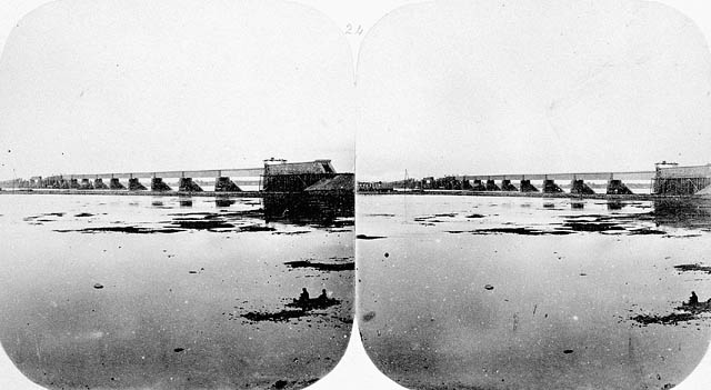
Stereoscopic photograph of the Victoria Bridge construction in progress from Pointe St. Charles (MIKAN 3357662)
The landscape and population of Pointe St. Charles changed dramatically upon completion of the Lachine Canal in 1848, and further still with the new railway infrastructure and construction of the Victoria Bridge to Montréal’s south shore. Several companies were drawn to the area; new jobs were created, and land previously given to agriculture was bought for residential housing. According to Héritage Montréal, by the beginning of the 20th century, Pointe St. Charles had become the largest industrial sector not only in Montréal but in all of Canada. It was at this time that The Pointe also became the quintessential example of an ethnic melting pot. Populated primarily by English (75%) and French (25%) Canadians, The Pointe increasingly became home to many different ethnic groups.

“Trevithick” railway engine under construction at Pointe St. Charles, from the Alexander Mackenzie Ross collection by William Notman, 1859 (MIKAN 3192802)
Several factors would contribute to The Pointe’s dramatic turn from Canada’s largest industrial sector to one of its most notorious slums. The Great Depression was the first event that contributed to the decline of the area’s primary economic activities. This was followed by the exodus of various factories and businesses to other industrial areas around Montréal, then culminating with the opening of the St. Lawrence Seaway in 1959 and the closing of the Lachine Canal. Adding further to the area’s decline was the building of expressways that now run along The Pointe’s north and southwest borders. The Richard Arless photographic collection held by Library and Archives Canada substantiates the existence of these slum conditions. Montréal-born Richard Graham Arless (1906-1995) began his career as a Second World War military photographer. After the war, he worked for various newspapers and magazines, eventually opening his own commercial studio in Montréal. His photographs of the slum conditions of Pointe St. Charles, all taken on the same April day in 1946, capture the bleakness and poverty of this once vital, now broken-down and battered neighbourhood.

Children playing in a courtyard in the Pointe St. Charles district, April 25, 1946 by Richard Arless (MIKAN 3380642)

View of a child in a narrow, garbage-strewn lane in Pointe St. Charles district, April 25, 1946 by Richard Arless (MIKAN 3380643)
The people of Pointe St. Charles have always been a gregarious and hardy bunch. As their population dwindled and their neighbourhood and living conditions deteriorated, the residents banded together to confront and improve their lot. Community groups were started to improve housing, build parks and promote recreation and health care.
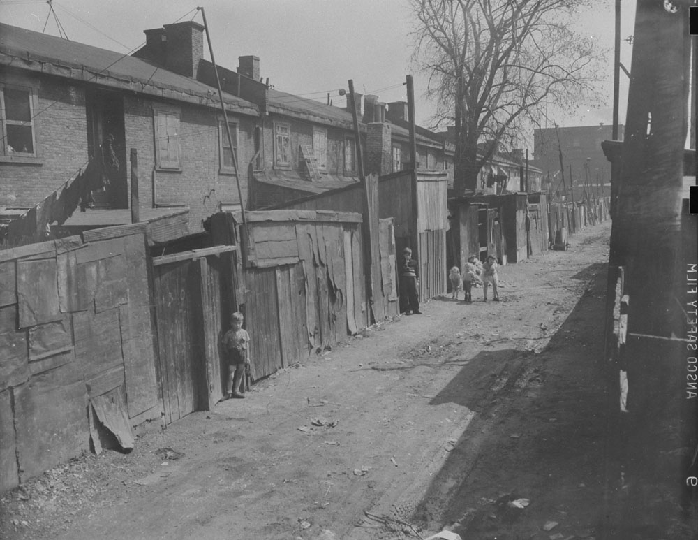
View of a dilapidated back alley in Pointe St. Charles district, April 25, 1946 by Richard Arless (MIKAN 3380652)
Most recently, The Pointe has experienced a revitalization. Land around the Lachine Canal was transformed for recreational use with bike paths, while many of the abandoned factories have been converted into condos that have attracted many new residents.

Pingback: This week’s crème de la crème — May 30, 2015 | Genealogy à la carte
Very Nicely done. Brought back some memories. Thanks to the excellent work of staff member Judith Enright, another piece or our heritage is kept from being forgotten. Kudos!
Love this photo of kids playing in the laneways of PSC
Proud to see my Grandfather’s photography archived this way.
Can anyone confirm the location of O’Brien’s Grocers? They had a corner store on Island and Manufacture according to a collection of photos about Pointe St-Charles. Someone corrected the notation in the comment section and said their store was on Island and Richardson. My grandparents, not the O’Brien’s, had a small convenience store on Island and Richardson during the 1930’s and 1940’s. Are we talking two separate stores or is it the same store and my grandparents either bought the business from or sold the business to the O’Brien’s?
The Lovell’s Montreal Directory (1842-1992) might be able to help you. Hopefully you can solve your mystery using the city directory!
I cannot seem to locate information from 1900-1940? Can you please direct me to those specific years in Montreal? Thank you!
To locate the directories for 1900-1940, it’s on the right hand side of the screen, select “Montréal et sa banlieue.” If you have any other questions, feel free to use our Ask us a genealogy question online form.
Thank you for your direction. I have been able to track the history of my ancestors’ homes in Montreal using your advice. I really appreciate your direction on this matter.
Best regards,