By Dalton Campbell
Dr. Philip Aron “Phil” Edwards earned five Olympic bronze medals in the 1920s and 1930s. It was the most career Olympic medals won by a Canadian athlete to that point and a Canadian record that would stand for 70 years.

Phil Edwards crossing the finish line, 1928 Olympics (a150990)
Nicknamed “The Man of Bronze,” his specialty was the middle distance. He finished on the podium at three Olympic Games: the 1928 Amsterdam Olympics (4 × 400 metre relay), the 1932 Los Angeles Olympics (800 m, 1500 m and 4 × 400 m relay) and the 1936 Berlin Olympics (800 m).
In 1936, he was the inaugural winner of the Lou Marsh Trophy as Canadian athlete of the year.
Edwards was born in Guyana (then called British Guiana). As a young man, he moved to the United States, studying at New York University and competing in track. But his British citizenship prevented him from joining the U.S. Olympic team. Edwards was invited to join the Canadian Olympic team for the 1928 Games. In 1931, he moved to Canada and enrolled at McGill University, where he joined the track team.

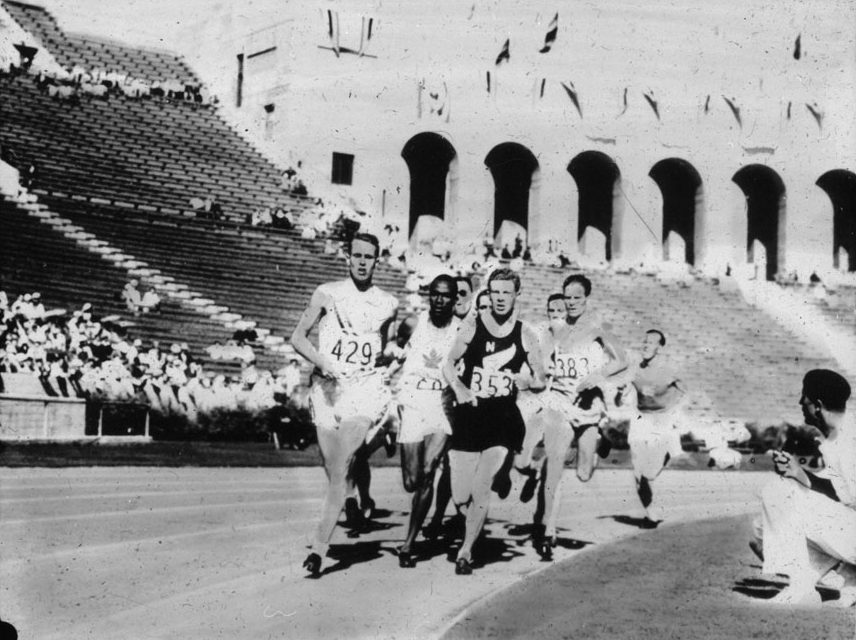
Phil Edwards leading the field, 1932 Olympics (a150989)
Edwards was the first Black Canadian to win an Olympic medal. He was one of few Black Canadian Olympians in the first half of the 20th century, along with John Armstrong Howard, Sam Richardson and Ray Lewis, who won bronze with Edwards on the Canadian relay team at the 1932 Olympics.
Edwards had an extraordinary year and a half in 1935–36. He led McGill to a fifth consecutive Canadian university track title in the autumn of 1935. Before the 1936 Olympics in Berlin, he completed his medical studies, becoming one of the first Black graduates from the McGill medical program. The Globe and Mail reported that he was named co-captain and associate physician of the 1936 Canadian Olympic team. At year’s end, he won an unofficial triple crown when he was named Canadian athlete of the year, Canadian amateur athlete of the year and Canadian Press male athlete of the year.
Edwards won bronze in Berlin, where he ran in the face of open racial hostility from Germany’s Nazi government, which saw the Olympic Games as a propaganda showcase for its racist ideas. He was among the Black athletes who won medals, which included U.S. track stars Jesse Owens and Mackenzie “Mack” Robinson, older brother of Jackie Robinson.
On the return trip to Canada, the team was booked in a hotel in London, England. Edwards was refused a room, so the rest of the team decided to leave the hotel and find accommodations where their teammate would be accepted.
Dr. Edwards’ medical specialty was tropical and chest diseases. In 1937, he was appointed resident house surgeon at Barbados General Hospital. He served with the Canadian Army as a captain during the Second World War. After the war, he studied at McGill and practised at the Royal Victoria Hospital in Montréal, where he would become head of the parasitology department. He worked with the Red Cross program in Congo in 1960.
Phil Edwards, second from left, competing at the 1932 Olympics (a150988)
He managed British Guiana’s (now Guyana) Olympic team at the 1956 Olympics, held in Melbourne, Australia.
His record for most Olympic medals by a Canadian—five—was unbeaten for 70 years. In 2002, speed skater Marc Gagnon matched this achievement. In 2006, speed skater Cindy Klassen earned her sixth Olympic medal, breaking the record. In 2010, speed skater and cyclist Clara Hughes also earned a sixth medal.
Edwards died in 1971, just short of his 64th birthday. He was survived by his wife, three daughters and two siblings. The Phil A. Edwards Memorial Trophy, named in his honour, has been awarded annually to the top Canadian track athlete since 1972. In 1997, Dr. Phil Edwards was elected to Canada’s Sports Hall of Fame.
Additional resources
- Photograph of Edwards celebrating with Canadian sprinter Percy Williams, 1928 (a150983)
- Radio program featuring Edwards, “Trans-Canada Matinee” (ISN 382550)
- Interview with Edwards and other Canadian athletes, “Crysdale and Company” (ISN 382973)
- File on Edwards, Stanley Grizzle fonds (MIKAN 3728970)
- Video of 1932 Olympics (ISN 385532, 331681)
- Video of 1936 Olympics (ISN 191253, 300159)
- Highlights of 1932 Olympics (ISN 447089)
- Footage of 1932 and 1936 Olympics (ISN 300321)
- Highlights and footage of 1936 Olympics (ISN 191253, 300159, 33542)
- Rapid Ray: The Story of Ray Lewis, by John Cooper (OCLC 49047597)
Dalton Campbell is an archivist in the Science, Environment and Economy section of the Private Archives Division at Library and Archives Canada.