This article contains historical language and content that some may consider offensive, such as language used to refer to racial, ethnic, and cultural groups. Please see our historical language advisory for more information.
The Mackenzie Valley Pipeline Inquiry (MVPI), also known as the Berger Inquiry, was enacted fifty years ago in 1974 by the Canadian Government. The purpose of the Inquiry was to investigate and report findings, which would be followed by appropriate actions. The final report (Volume One and Volume Two) was published in 1977. Library and Archives Canada (LAC) holds the original collection of the Inquiry records, and they are managed by Government Archives Division.
This is the first of a three-part series. Part one will revisit the events prior to the Inquiry and the areas the proposed project would impact. Part two will focus on people who were involved in the Inquiry, and part three will include specific details on how to search through the records of the MVPI.

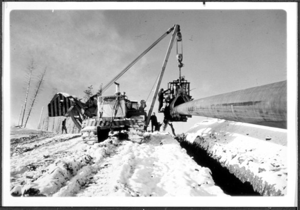
Coating or taping machine used in laying pipeline during ditching operation for a 24″ pipeline construction job. Photograph presented as evidence to the Mackenzie Valley Pipeline Inquiry by G. L. Williams, 21-22 April 1975 (MIKAN 3238077).
The Mackenzie River is known as “Dehcho” (big river) by the Slavey (Dene), “Kuukpak” (great river) by the Inuvialuk and “Nagwichoonjik” (river flowing through a big country) by the Gwich’in (Dene). The colonial name of “Mackenzie” originated after the explorer Alexander Mackenzie visited the area in 1789.
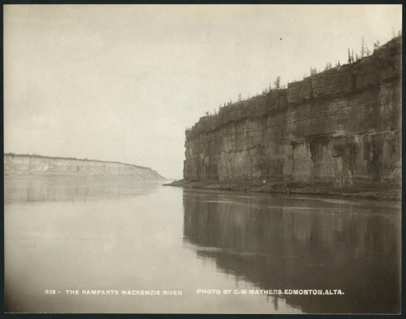
The Mackenzie River winds through the Northwest Territories (NT), flowing northwest to the Mackenzie Delta. Just past the midway area of the river, immense limestone cliffs known as the Fee Yee (Ramparts) rise from the edge of the Mackenzie River. The river continues until it reaches the Mackenzie Bay at the Beaufort Sea in the Arctic Ocean. To the west of the river in NT and ending in the Yukon is the Mackenzie Mountain Range, a northern extension of the Rocky Mountains.

Fee Yee (The Ramparts), Mackenzie River. Original title: The Ramparts, Mackenzie River (e011368927).
Treaty 11
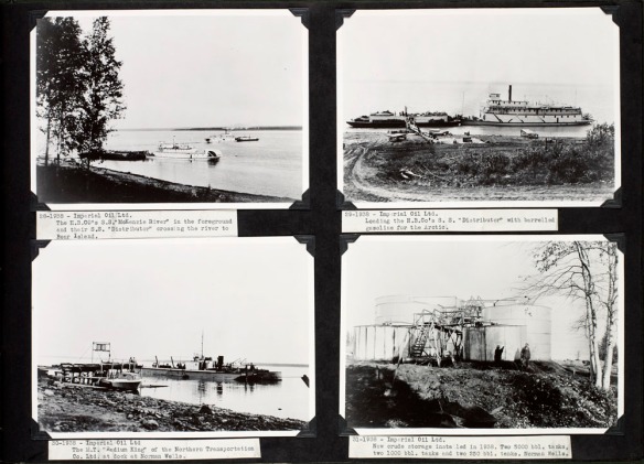
The Dene had already given the name “Le Gohlini” (where the oil is) to Norman Wells, predating the arrival of colonial visitors. Tar was applied for waterproofing canoes and was made from small amounts of oil obtained from seepages. The sharing of their knowledge of the oil seepages resulted in Imperial Oil’s drilling program in 1919 and 1920. In 1920, oil was struck in the area of “Tutil’a” (“the place where the rivers meet” in Sahtu Dene; “Fort Norman” in English), and the construction of a small oil refinery followed. These events led to the signing of Treaty 11 in 1921 and 1922 by the Crown and representatives of the Dehcho, Tłı̨chǫ, Sahtu and Gwich’in peoples. The area covers 950 000 km2 of present-day Yukon, Northwest Territories and Nunavut. The Canadian Government’s interpretation of Treaty 11 secured title of these lands to the Crown, whereas the Dene saw the treaty as a peace and friendship agreement.

S.S. “Mackenzie River” at Norman Wells, S.S. “Distributor” being loaded with barrelled gasoline, M.T. “Radium King” at Norman Wells, Imperial Oil ltd. tanks at Norman Wells, Northwest Territories. Date: 1938 (e010864522).
In 1968, a massive oil strike at Prudhoe Bay in Alaska moved energy investors to create proposals to move the oil and natural gas to southern United States and Canadian markets. The same year, the Task Force on Northern Oil Development was created, which resulted in the development of the federal government’s official northern pipeline guidelines, published in 1970 and expanded in 1972.
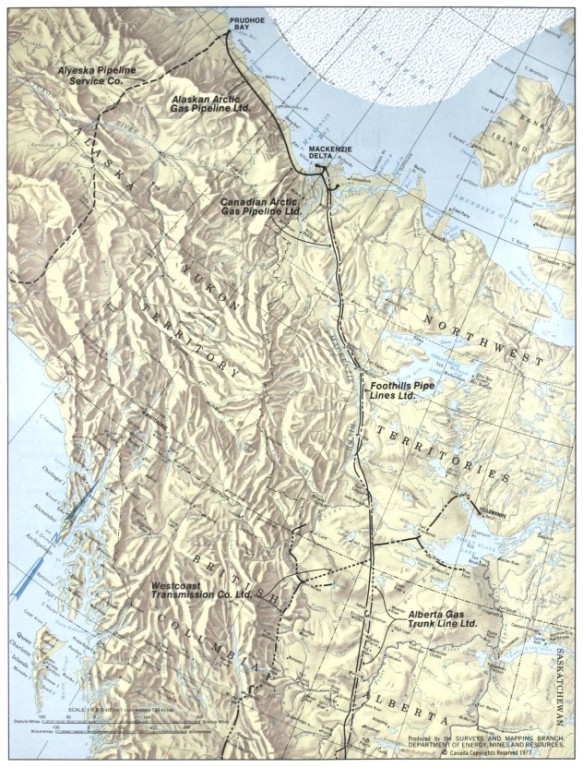
A pipeline proposal by Arctic Gas would have construction originating at Prudhoe Bay, Alaska on the Beaufort Sea to cross through the Yukon, Northwest Territories and Alberta and to include transportation of additional gas resources along the way to the United States.

The proposed route for the Mackenzie Valley Gas Pipeline. Map part of: Northern frontier, northern homeland: the report of the Mackenzie Valley Pipeline Inquiry, volume one / Thomas R. Berger. 1977. Publication with map.
Library and Archives Canada/OCLC 1032858257, p. 6
As complex as the planning and construction of the infrastructure to support and build the pipeline was, the same complexity existed for the effects the pipeline would have on the environment, wildlife, and people of the land. The pipeline would also bring additional associated industrial development of an unknown scope. The result was that the Mackenzie Valley Pipeline was never built, although new projects would be proposed in its place.
Discovering the MVPI digitized collection materials
The records of the MVPI were transferred to the public archives of Canada in February 1978. All MVPI records are open to the public for research purposes, though not all records are digitally available. Additional keywords for searches may include “Berger Commission” or “Berger Inquiry”.
To become familiar with using Collection Search and to begin your MVPI records search, use the following links:
The MVPI collection includes the following digitized transcripts:
- Proceedings and testimony of
- community hearings of 77 files of textual material dated 1975–1976.
- Includes proceedings and testimony in 77 volumes (C1-C77)
- formal hearings of 217 files of textual material dated 1975–1976.
- community hearings of 77 files of textual material dated 1975–1976.
- Exhibits presented to the Inquiry
- Community hearing exhibits of 700 files of textual records dated from 1975–1976.
- Each file is a submission with recorded exhibit number, date and author.
- Community hearing exhibits of 700 files of textual records dated from 1975–1976.
Elizabeth Kawenaa Montour is an archivist in the Government Archives Division of the Government Records Branch at Library and Archives Canada.


Elizabeth, Thanks for the introduction to this fascinating topic and directing attention to the different understanding of Treaty 11. Once again, one wonders if there was a sinister side to the issue intended to take advantage of the indigenous people as in the case of the Osage in Oklahoma. Eager to see Part 2! Fred
Thank you, Fred, for reading part 1 of the 3-part blog series about this important inquiry . Part 2, titled Fifty Years after the Mackenzie Valley Pipeline Inquiry: Listening to Voices (Part 2), will be published on May 2.