

By Elizabeth Kawenaa Montour
This article contains historical language and content that some may consider offensive, such as language used to refer to racial, ethnic, and cultural groups. Please see our historical language advisory for more information.
The Mackenzie Valley Pipeline Inquiry was enacted fifty years ago in 1974 by the Canadian Government. Library and Archives Canada (LAC) holds the original collection of the Inquiry records, which are managed by Government Archives Division.
This is the final blog of a three-part series on the Mackenzie Valley Pipeline Inquiry (MVPI). This blog will focus on providing instructions on locating a selection of specific types of MVPI records through Collection Search.
Discovering MVPI digitized collection materials
The records of the MVPI were transferred to the Public Archives of Canada in February 1978. All MVPI records are open to the public for research purposes, though not all MVPI records are digitally accessible online. A digitally accessible record will show the digitized image of the record above the Record Information Page when retrieved and opened through Collection Search. These records can be requested and accessed on-site at LAC.
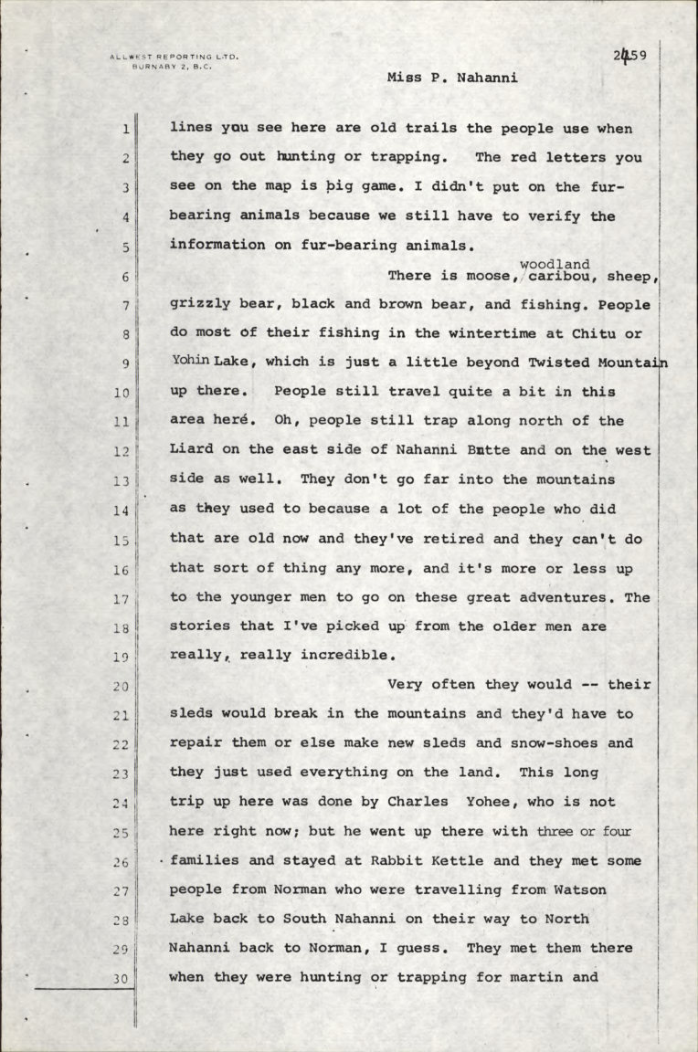
Transcript Number C24 – Trout Lake and Nahanni Butte, NWT from transcripts of community hearings. Date: 24 August 1975. Page 71 of 80 (e011412138).
Transcript Number 117 – Inuvik, NWT from transcripts of formal hearings. Date: 26 January 1976. Page 83 of 164 (e011412099).
Resources for records searches
The following information provides more specific guidance on searching for MVPI records.
The main sous-fonds is titled Mackenzie Valley Pipeline Inquiry (multiple media), or you may find it by using the search term “Mackenzie Valley Pipeline Inquiry” in Collection Search to find the result “Reference: R216-165-X-E, RG126. Date: 1970-1977”. Additional keywords for searches may include “Berger Commission” or “Berger Inquiry”.
The MVPI sous-fonds contains three main groups of series-level records, which are Transcripts of proceedings and testimony (digitized), Exhibits presented to the Inquiry (digitized) and Operational and administrative records (not digitized).
Each record may contain an electronic link to a related finding aid. This is found in the “Record information – Details section” and listed as “Finding aid: show detail”.
1 – Transcripts of proceedings and testimony – Reference: R216-3841-6-E, RG126
Please note: Shortcuts for locating both “formal hearings transcript” and “community hearings transcript” files using Collection Search are listed after section 3 – Operational and administrative records.
For formal hearings, reference “R216-172-7-E, RG126. Date: 1974-1976. Digitized”.
The sub-series includes 217 digitized transcript files, which are identified by number and location. The majority of the formal hearings were held in Yellowknife, with the remainder held in Inuvik (Northwest Territories), Whitehorse (Yukon) or Ottawa (Ontario).
Finding aid 126-5 is a verified file list of the formal hearing transcripts indicating transcript number, file title (the location), dates and permanent volume numbers.
For community hearings, reference “R216-169-7-E, RG126. Date 1975-1976. Digitized”.
The sub-series includes 77 digitized transcript files. Transcripts are identified by number and location. Community hearing transcript numbers are prefixed with the letter “C”.
Finding aid 126-8 is a verified file list of the community hearings transcripts including transcript number, file title (the location), parts, dates and permanent volume number.
Finding aid 126-3, from pages 111–120, is a list of Inquiry community witnesses and includes transcript numbers. In order to locate the Inquiry community transcript, preface the transcript number with the letter “C”. For example, to find text about “Antoine Abalon”, enter the search terms “Mackenzie C-18”. The result is Transcript Number C18 – Fort Good Hope, NWT. Scroll down list of names to Antoine Abalon, p. 1795.
2 – Exhibits presented to the Inquiry – Reference: R216-3840-4-E, RG126 Date: 1972-1977
Community hearings exhibits “R216-168-5-E, RG126 Date: 1975-1976” includes 700 digitized files. Exhibits are identified as “Submission” followed by a number with a “C”-prefix (e.g. Submission C585). The sub-series contains 627 digitized files, and 73 were not digitized due to the file folders being empty or for copyright reasons.
For Vancouver hearings exhibits, reference “R216-173-9-E, RG126 Date: 1976. Not digitized”. Records consist of exhibits from the Vancouver hearings of the MVPI held in May and June 1976. CV1-CV22 each denote a community exhibit with a description, person submitting and date. Hearings were also held in nine other centres in southern Canada (RG126, Vol. 9).
Formal hearings exhibits “R216-171-5-E, RG126 Date: 1975-1977” include 906 exhibits and are not digitized.
Additional MVPI records not included with the three main groups described above are listed below.
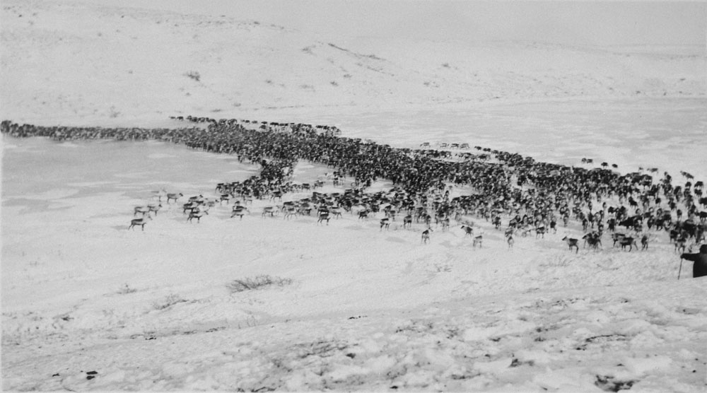
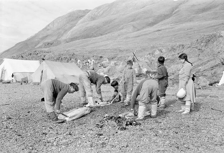
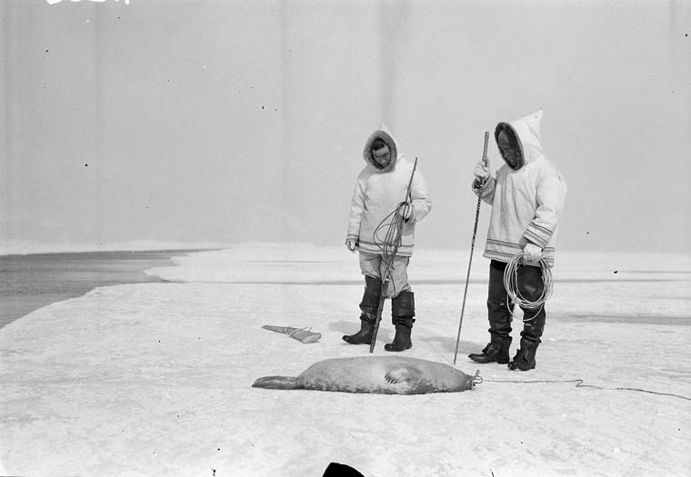
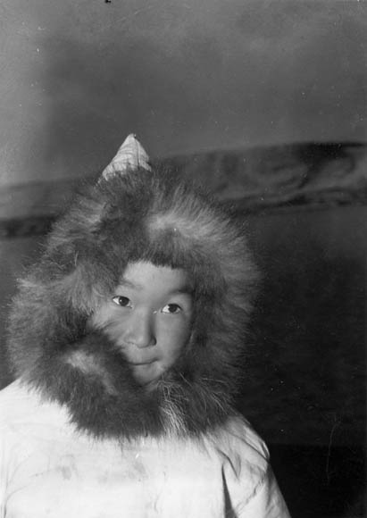
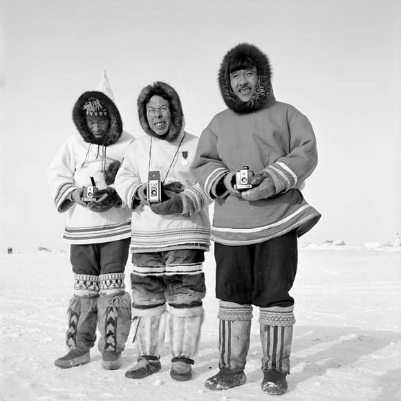
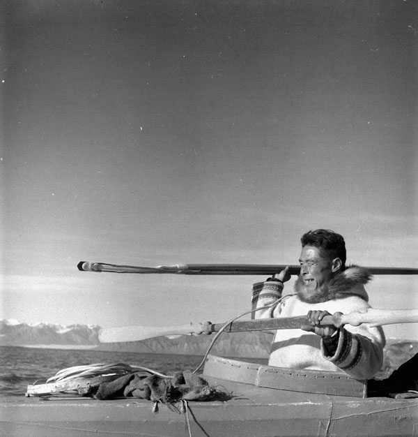
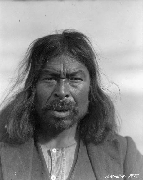
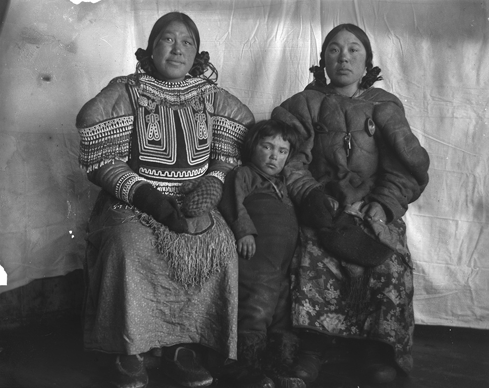
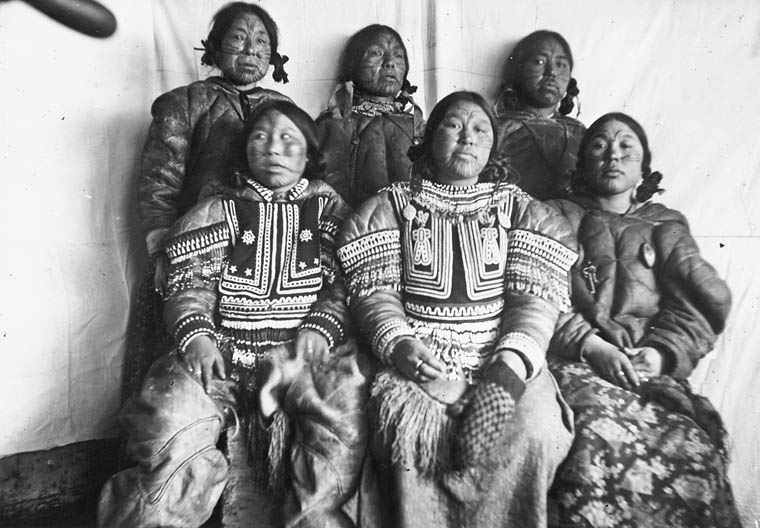
For photography, search for “Exhibits presented to the Mackenzie Valley Pipeline Inquiry, Reference: RG126, R216, 1978-115 NPC Box 3929. Date 1974-1975”. The accession includes 165 black and white and 819 colour photographs. They are not digitized. The accession consists of photographs depicting the planning and execution of the Mackenzie Valley Pipeline that were submitted as exhibits to the Inquiry. Subjects include, but are not limited to, land conditions, terrain, wildlife, construction views, disturbances to the tundra, forests, geological formations, Ellesmere Island, caribou entangled in wire, Banks Island, seismic reports, muskox habitat and environmental hazards to the pipeline.
For maps, search for “Exhibits by special interest and northern community groups to the Mackenzie Valley Pipeline Inquiry, Reference: RG126M 78903/14, 78903/14 CA. Date: 1972-1976”. The accession is not digitized. Accession consists of cartographic items which were presented by special interest and Northern community groups as exhibits to the MVPI. It includes technical details relating to the construction of the pipeline, environmental impact assessment maps and sets of land use maps. The accession also includes maps showing the pipeline corridors and the actual pipeline routes as proposed by Canadian Arctic Gas Pipeline Ltd. and Foothills Pipeline Ltd.
3 – Operational and administrative records Reference: R216-174-0-E, RG126 Vol. 72. Date: 1970-1977
The series includes textual recording, sound recording and moving images, and it is not digitized. The series consists of correspondence with the public, participants and staff members on all aspects of the Inquiry’s work; files on administrative arrangements regarding the Inquiry’s actual operations; Justice Thomas Berger’s memoranda to various parties; speeches delivered by Berger; French and English editions of the final reports; timetables of events; summaries of proceedings; indexes; posters and lists of documents. The series includes six lower-level descriptions: Committee for Original People’s Entitlement, Correspondence – General, Canadian Broadcasting Corporation, Canadian Arctic Gas Pipelines LTD, Canadian Arctic Resources Committee – Northern Assessment Group and Canadian Arctic Resources Committee.
Navigating the records using shortcuts
The search methods suggested here are not examples of methods that are considered regular search terms, but irregular techniques based on how data was input into the system and created for researcher convenience. They cannot be applied to other areas of the database.
Shortcuts to locate “community hearing transcripts”
To find a community transcript by location
If you know the location of the community hearing, enter the search terms “Mackenzie transcripts [location]” into Collection Search (archives filter) and note “transcripts” (must be plural). For example, “Mackenzie transcripts Aklavik”.
The results will include all the transcripts of the hearings in that location.
For example, the above search inquiry would yield the search results Transcript Number C40 – Aklavik, NWT, Transcript Number C3 – Aklavik, NWT and Transcript Number C1 – Aklavik, NWT.
To find a community transcript by date
Enter the search terms “transcript DD-MONTH-YYYY” into Collection Search (archives filter).
Note: the date must be entered in this order and the month must be spelled out. For example, “transcript 5 August 1975”.
The result you would find in this example is Fort Good Hope, NWT.
To find a date of a community hearing
Enter the search terms “community hearings transcript” into Collection Search (archives filter)
Go to “Record Information-Details”. Click and open “Finding aid”.
Finding Aid 126-8 is a verified file list of the community hearings transcripts including transcript number, file title [location], parts, date and permanent volume number.
To find a community transcript by transcript number
Enter the search terms “Mackenzie C-number” into Collection Search (archives filter). For example, “Mackenzie C-18” (with or without the hyphen).
The result you would find in this example is Transcript Number C18 – Fort Good Hope, NWT.
To find the sound recording of a particular community hearing
Enter the search terms “Date [YYYY-MM-DD] Mackenzie” into Collection Search (archives filter)
Note: the numeric date must be entered in this order.
The sound recording must be accessed on-site at LAC.
Shortcuts to locate “formal hearings transcripts”
To find a date of a formal hearing
Enter the search term “formal hearings transcript” into Collection Search (archives filter).
Go to “Record Information-Details”. Click and open “Finding aid”.
FA-126-5 is a verified file list of the formal hearings transcripts, including transcript number, file title [location], parts, dates and permanent volume numbers.
To find a formal hearing transcript by date
Enter the search terms “transcript DD MONTH YY” into Collection Search (archives filter).
Note: the date must be entered in this order and the month must be spelled out. For example, “transcript 8 April 1975”.
The result you would find in this example is Yellowknife, NWT.
To find a formal hearing transcript by transcript number
Enter the search terms “Transcript number” into Collection Search (archives filter). For example, “Transcript 35”
The result you would find in this example is Transcript Number 35 – Yellowknife, NWT.
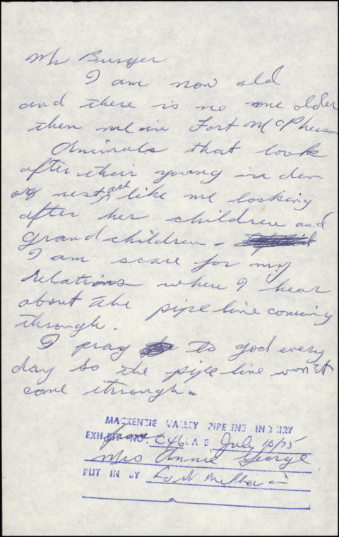
Exhibit Submission C46, RG126, Volume number: 3. Letter written by Mrs. Annie George, Elder, to Mr. Berger, MVPI Commissioner. Date: July 1975. Exhibit presented to the Inquiry at Community hearings. (e011407938)
Additional resources
- Fifty Years after the Mackenzie Valley Pipeline Inquiry: Environmental Impacts in the Northwest (Part 1), by Elizabeth Kawenaa Montour, Library and Archives Canada Blog
- Fifty Years after the Mackenzie Valley Pipeline Inquiry: Listening to Voices (Part 2), by Elizabeth Kawenaa Montour, Library and Archives Canada Blog
Elizabeth Kawenaa Montour is an archivist in the Government Archives Division of the Government Record Branch at Library and Archives Canada.


![On the left of the graphic, Tatânga Mânî [Chief Walking Buffalo] [George McLean] in traditional regalia on horse. In the middle, Iggi and girl engaging in a “kunik”, a traditional greeting in Inuit culture. On the right, Maxime Marion, a Métis guide stands holding a rifle. In the background, there is a map of Upper and Lower Canada, and text from the Red River Settlement collection.](https://thediscoverblog.com/wp-content/uploads/2019/02/blog-banner-1.jpg)


![Six small sketches of different types of icebergs in pale colours with the caption: “Vanille, fraise, framboise – boum, servez froid!” [Vanilla, strawberry, raspberry—boom, serve cold!]](https://thediscoverblog.com/wp-content/uploads/2019/08/e008444012.jpg)
![On the left of the graphic, Tatânga Mânî [Chief Walking Buffalo] [George McLean] in traditional regalia on horse. In the middle, Iggi and girl engaging in a “kunik”, a traditional greeting in Inuit culture. On the right, Maxime Marion, a Métis guide stands holding a rifle. In the background, there is a map of Upper and Lower Canada, and text from the Red River Settlement collection.](https://thediscoverblog.com/wp-content/uploads/2019/02/blog-banner.jpg)


