Fifty Years after the Mackenzie Valley Pipeline Inquiry: Listening to Voices (Part 2)

Version française

Mackenzie Valley Pipeline Inquiry Blog banner with a view of Mackenzie River Delta from Black Mountain near Aklavik in Northwest Territories.By Elizabeth Kawenaa Montour

This article contains historical language and content that some may consider offensive, such as language used to refer to racial, ethnic, and cultural groups. Please see our historical language advisory for more information.

The Mackenzie Valley Pipeline Inquiry (MVPI), also known as the Berger Inquiry, was enacted fifty years ago in 1974 by the Canadian government. The purpose of the Inquiry was to investigate the potential impacts of the pipeline and report findings, which would be followed by appropriate actions. The final report (Volume One and Volume Two) was published in 1977. Library and Archives Canada (LAC) holds the original collection of Inquiry records, which are managed by the Government Archives Division.

This is part two of a three-part series on the MVPI. This blog will highlight two individuals who were central to the thoroughness of the Inquiry process as well as provide additional search methods for Inquiry records.

Part one presented a glimpse of the people and land of the Yukon and Northwest Territories (NWT) who would be affected by the proposed Mackenzie Valley Pipeline, along with a narrative of events that led up to the enactment of the Inquiry by the Canadian government. The final blog, part three, will focus on more specific searches for the records.

Commissioner Thomas R. Berger and interpreter and Inuk broadcaster Abraham Okpik

The Inquiry to study the potential environmental and socio-economic impacts of the proposed gas pipeline project was headed by Justice Thomas R. Berger. A former Justice of the B.C. Supreme Court, he possessed legal experience in First Nations issues. He had recently represented the Nisga’a and argued the Aboriginal title case Calder et al. v. Attorney-General of British Columbia, [1973] S.C.R. 313. This led to the 1973 Calder decision by the Supreme Court of Canada, which recognized that Aboriginal title to land existed prior to colonization and that Nisga’a land title had never been extinguished.

Abraham “Abe” Okpik, who was born in the Mackenzie River Delta, was an interpreter for the Inquiry in 1974. He also served as a linguistic representative for CBC to report on the Inquiry hearings. Okpik’s language skills combined with his life experiences were crucial for the Inquiry to establish communication and understanding with people from different Arctic communities.

In 1965, Okpik was the first Inuk to sit on the Council of the Northwest Territories (NWT). His legal surname at the time was “W3-554” due to the Canadian government system of using disc numbers to identify people in the North. Okpik eventually chose his new surname and was selected to head Project Surname in 1970. Under this project, Okpik visited Inuit camps and communities in northern Quebec and the NWT to record the surnames people wanted to replace their identification numbers. In 1976, Okpik was awarded the Order of Canada in recognition of his contributions to the preservation of the Inuit way of life and his work on the Berger Inquiry.

A colour portrait photograph of Abe Okpik standing indoors wearing a black Inuit parka with yoke and red, yellow and green floral embroidery on a white yoke with red fringe. He has black fur mitts on.

Abe Okpik, 1962 (e011212361).

Conclusions of the Inquiry

Commissioner Berger summed up his thoughts in his November 1978 article on the MVPI with comments on industrialization, energy waste, the creation of wilderness parks and whale sanctuaries, and the need for humanity to reflect on its use of resources. He recognized the North as the last frontier and that the pristine and undeveloped areas were critical habitat for many creatures and their continued survival. He writes that in his MVPI report there are two sets of conflicting attitudes and values: “the increasing power of our technology, the consumption of natural resources and the impact of rapid change” versus “the growth of ecological awareness, and a growing concern for wilderness, wildlife resources and environmental legislation.”

The Inquiry concluded that a pipeline along the Mackenzie Valley to Alberta was feasible, but that it should only proceed after further study and after the settlement of Indigenous land claims. Based on this conclusion, a ten-year moratorium on construction was declared.

Voices speaking for land and life

The Inquiry was groundbreaking in its implementation of direct consultation that included hearings with the people of the communities that would be impacted by the project. They were aware that the pipeline would bring change and affect their relationship with the animals and the land. They spoke of their way of life and of knowledge that had been passed to them. Audio recordings of these oral testimonials are culturally invaluable. Their knowledge at that specific moment in time is preserved and available for future generations to hear.

Black-and-white photograph of a herd of caribou moving over frozen river and snow-covered landscape.

Reindeer taking part in the Canadian Reindeer Project crossing the Mackenzie River, 1936 (a135777).

Fred Betsina, a 35-year-old Dene from Detah Village, NWT, explained at the Detah Community Hearing why he did not want a pipeline. He told how he knew from trapping and hunting caribou that they were not able to jump over a 48-inch pipe—that they can’t jump higher than 12 inches, so instead they need to go around whatever is blocking their path. He stated that he wanted to see the land settlement claims settled before he saw a pipeline. His last comment was, “… us Indians. We got no money in the bank, nothing … The only money we got in the bank is the cash out in the bush … We get our meat from there, and fish is the cash … that’s what you call a bank here…”  He spoke for the wildlife, for his people and for his family’s needs.

The gathering of people from distantly located communities also presented opportunities to forge new friendships and strengthen alliances. The Inquiry gave a space for informal discussion on economic and political subjects.

Discovering MVPI collection materials

The records of the MVPI were transferred to the public archives of Canada in February 1978. All MVPI records are open to the public for research purposes, though not all records are digitally available.

Screenshot of Collection Search – Research Information Page with three dark horizontal bars with text: Record information – Brief, Record information – Details, and Ordering and viewing options.

Mackenzie Valley Pipeline Inquiry (multiple media) R216-165-X-E, RG126. Date: 1970–1977 (MIKAN 383).

Additional sources and tips for records searches

The following is to provide more specific guidance on searching for MVPI records in Collection Search.

On the Record Information Page for the Mackenzie Valley Pipeline Inquiry (Reference: R216-165-X-E, RG126), there are three sections: Record information – Brief, Record information – Details, and Ordering and viewing options.

If you open the second section (Record information – Details), you will find a link titled, “View lower-level description(s).” Clicking on that link will open the three main series of records: Transcripts of proceedings and testimony, Exhibits presented to the Inquiry, and Operational and administrative records

Opening one of three series of records above will link to the Record Information Page for that series. To view the lower-level records within each series, open the “Record information – Details” section and click on the “View lower-level description(s)” link.

In Transcripts of proceedings and testimony (R216-3841-6-E, RG126), you will find two lower-level descriptions:

In Exhibits presented to the Inquiry (R216-3840-4-E, RG126), you will find four lower-level descriptions:

In Operational and administrative records (R216-174-0-E, RG126), you will find six lower-level descriptions:

*Please note not all MVPI records are available online digitally. MVPI records that are not digitally accessible online will have to be requested and accessed onsite at LAC. A digitally accessible record will show the digitized image of the record at the top of its Record Information Page.

The final blog in this series will provide detailed strategies to navigate the records.


Elizabeth Kawenaa Montour is an archivist in the Government Archives Division of the Government Record Branch at Library and Archives Canada.

Fifty Years after the Mackenzie Valley Pipeline Inquiry: Environmental Impacts in the Northwest (Part 1)

Version française

Mackenzie Valley Pipeline Inquiry Blog banner with a view of Mackenzie River Delta from Black Mountain near Aklavik in Northwest Territories.By Elizabeth Kawenaa Montour

This article contains historical language and content that some may consider offensive, such as language used to refer to racial, ethnic, and cultural groups. Please see our historical language advisory for more information.

The Mackenzie Valley Pipeline Inquiry (MVPI), also known as the Berger Inquiry, was enacted fifty years ago in 1974 by the Canadian Government. The purpose of the Inquiry was to investigate and report findings, which would be followed by appropriate actions. The final report (Volume One and Volume Two) was published in 1977. Library and Archives Canada (LAC) holds the original collection of the Inquiry records, and they are managed by Government Archives Division.

This is the first of a three-part series. Part one will revisit the events prior to the Inquiry and the areas the proposed project would impact. Part two will focus on people who were involved in the Inquiry, and part three will include specific details on how to search through the records of the MVPI.

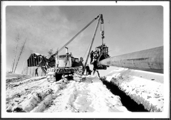
Caterpillar machinery with lift and claw holding pipeline to drop into parallel ditch in ground. Ground edged by snow. Several workers standing on snow and one standing on claw mechanism. Two tall trees on the left side of the picture with short branches with no leaves.

Coating or taping machine used in laying pipeline during ditching operation for a 24″ pipeline construction job. Photograph presented as evidence to the Mackenzie Valley Pipeline Inquiry by G. L. Williams, 21-22 April 1975 (MIKAN 3238077).

The Mackenzie River is known as “Dehcho” (big river) by the Slavey (Dene), “Kuukpak” (great river) by the Inuvialuk and “Nagwichoonjik” (river flowing through a big country) by the Gwich’in (Dene). The colonial name of “Mackenzie” originated after the explorer Alexander Mackenzie visited the area in 1789.

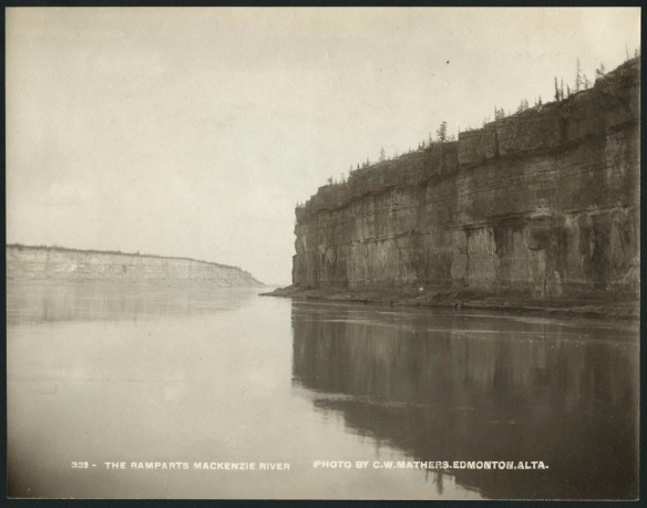
The Mackenzie River winds through the Northwest Territories (NT), flowing northwest to the Mackenzie Delta. Just past the midway area of the river, immense limestone cliffs known as the Fee Yee (Ramparts) rise from the edge of the Mackenzie River. The river continues until it reaches the Mackenzie Bay at the Beaufort Sea in the Arctic Ocean. To the west of the river in NT and ending in the Yukon is the Mackenzie Mountain Range, a northern extension of the Rocky Mountains.

Black and white photograph of a river with vertical flat cliffs on the right side. The top layer of the cliffs holds trees and vegetation. To the left side and further off in the distance is a similar geological feature. The river runs between the two features.

Fee Yee (The Ramparts), Mackenzie River. Original title: The Ramparts, Mackenzie River (e011368927).

Treaty 11

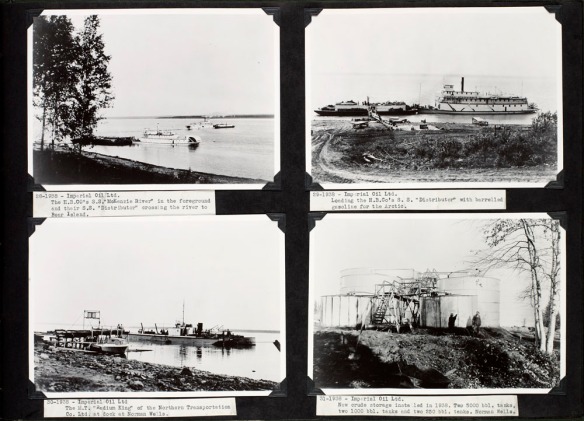
The Dene had already given the name “Le Gohlini” (where the oil is) to Norman Wells, predating the arrival of colonial visitors. Tar was applied for waterproofing canoes and was made from small amounts of oil obtained from seepages. The sharing of their knowledge of the oil seepages resulted in Imperial Oil’s drilling program in 1919 and 1920. In 1920, oil was struck in the area of “Tutil’a” (“the place where the rivers meet” in Sahtu Dene; “Fort Norman” in English), and the construction of a small oil refinery followed. These events led to the signing of Treaty 11 in 1921 and 1922 by the Crown and representatives of the Dehcho, Tłı̨chǫ, Sahtu and Gwich’in peoples. The area covers 950 000 km2 of present-day Yukon, Northwest Territories and Nunavut. The Canadian Government’s interpretation of Treaty 11 secured title of these lands to the Crown, whereas the Dene saw the treaty as a peace and friendship agreement.

Four black and white silver gelatin prints mounted on paper: three of boats in a river with shoreline scenes and one of crude storage tanks on shore.

S.S. “Mackenzie River” at Norman Wells, S.S. “Distributor” being loaded with barrelled gasoline, M.T. “Radium King” at Norman Wells, Imperial Oil ltd. tanks at Norman Wells, Northwest Territories. Date: 1938 (e010864522).

In 1968, a massive oil strike at Prudhoe Bay in Alaska moved energy investors to create proposals to move the oil and natural gas to southern United States and Canadian markets. The same year, the Task Force on Northern Oil Development was created, which resulted in the development of the federal government’s official northern pipeline guidelines, published in 1970 and expanded in 1972.

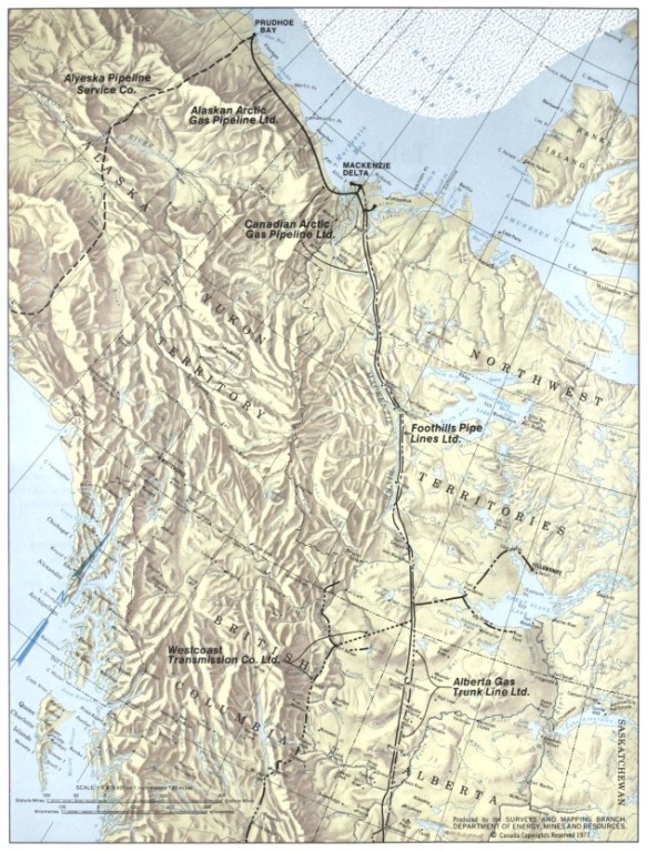
A pipeline proposal by Arctic Gas would have construction originating at Prudhoe Bay, Alaska on the Beaufort Sea to cross through the Yukon, Northwest Territories and Alberta and to include transportation of additional gas resources along the way to the United States.

Coloured map of physical land and water features with provincial, territorial and American state names. Pipeline companies’ names and sections affiliated with them are highlighted by solid or black broken lines.

The proposed route for the Mackenzie Valley Gas Pipeline. Map part of: Northern frontier, northern homeland: the report of the Mackenzie Valley Pipeline Inquiry, volume one / Thomas R. Berger. 1977. Publication with map.
Library and Archives Canada/OCLC 1032858257, p. 6

As complex as the planning and construction of the infrastructure to support and build the pipeline was, the same complexity existed for the effects the pipeline would have on the environment, wildlife, and people of the land. The pipeline would also bring additional associated industrial development of an unknown scope. The result was that the Mackenzie Valley Pipeline was never built, although new projects would be proposed in its place.

Discovering the MVPI digitized collection materials

The records of the MVPI were transferred to the public archives of Canada in February 1978. All MVPI records are open to the public for research purposes, though not all records are digitally available. Additional keywords for searches may include “Berger Commission” or “Berger Inquiry”.

To become familiar with using Collection Search and to begin your MVPI records search, use the following links:

The MVPI collection includes the following digitized transcripts:

  • Exhibits presented to the Inquiry
    • Community hearing exhibits of 700 files of textual records dated from 1975–1976.
      • Each file is a submission with recorded exhibit number, date and author.

Elizabeth Kawenaa Montour is an archivist in the Government Archives Division of the Government Records Branch at Library and Archives Canada.
Breaking ground: 150 years of federal infrastructure in British Columbia – Northwest Region: The Dominion Telegraph Service’s Yukon Telegraph Line

By Caitlin Webster

British Columbia joined Canada 150 years ago, and in the years that followed, federal infrastructure expanded throughout the province. This infrastructure is well documented throughout Library and Archives Canada’s collections. This eight part blog series highlights some of those buildings, services and programs, as well as their impact on B.C.’s many distinct regions.

As British Columbia negotiated its terms for joining Confederation, one of the conditions included the establishment of a telegraphic service. Canada’s Dominion (or Government) Telegraph Service, which formed part of the Department of Public Works, was responsible for providing this. It operated telegraph lines in remote areas not covered by railway telegraph systems or private firms. In B.C., the federal government operated lines in the south and on Vancouver Island, and as it expanded its presence in northern B.C. and Yukon in the 1890s, work began on the Yukon Telegraph Line.

In 1899, the Privy Council Office approved the construction of a telegraph line between Dawson City in what is now Yukon and Bennett, B.C. Now a ghost town, Bennett was once a thriving centre for the Klondike Gold Rush.

Black-and-white photograph of the town of Bennett, B.C., at the edge of Bennett Lake. There are buildings and temporary structures along the shoreline, with a mountainside in the background and a wooden bridge in the foreground.

Part of Bennett, B.C. (a016295-v8)

Soon after the line to Bennett was completed, work began on a branch line to Atlin, and then an extension from Atlin to the transcontinental line at Quesnel. This work finished in 1901, although the construction of various branch lines continued over the next decade. As the construction work progressed, the Department of Public Works built telegraph offices and stations at regular intervals along the line. Stations in towns and settlements often housed other federal government services such as post offices and customs houses. Operators at these stations worked regular business hours and enabled customers to send and receive telegrams.

Black-and-white photograph of the three-storey post office building in Atlin, B.C. A sign on the building reads “Dominion Government Telegraph Office.”

Post office in Atlin, B.C. (a046672-v8)

To help ensure that the line had sufficient voltage to carry telegraph messages between the stations, crews also constructed intermediate battery stations, also known as repeater stations, along the more remote sections of the line. At first, these “bush stations” were simple one-room cabins, housing both the assigned operator and the lineman. As these sites rarely saw customers requesting telegrams, both operators and linemen undertook the difficult work of keeping the telegraph wires in good order. In the summer of 1905, crews built second cabins at these isolated stations to ease some of the difficulties of living in such close quarters.

Black-and-white photograph of a young man and his dog sitting in front of a one-room log cabin.

One of the government telegraph cabins [Dominion Government Telegraph cabin, North of Hazelton; telegraph operator Jack Wrathall and dog sit in front of the cabin] (a095734-v8)

Even smaller were the refuge cabins, where linemen could stay overnight if caught in bad weather while maintaining the line. Spaced approximately 10 miles (16 kilometres) apart, these small 8 x 10-foot (2.4 by 3 metres) cabins contained a stove, bunk and limited food supplies.

The telegraph lines affected local First Nations, ranging from the Lhtako Dene, Nazko, Lhoosk’uz Dene and ?Esdilagh Nations near Quesnel to the Taku River Tlingit First Nation in Atlin. Early work on telegraph lines in the 19th century often proceeded without consultation or agreements with First Nations, which led to confrontations when work crews trespassed on their land. A number of First Nations made use of materials left from earlier abandoned telegraph lines, using the wire on bridges and traps. Some First Nations men worked on the telegraph lines, serving as construction workers, linemen and pack-train operators. The most famous among them was Simon Peter Gunanoot, who helped to construct the line and later worked delivering provisions to the bush stations. Accused of murder in 1906, he evaded searchers for 13 years before turning himself in. At his trial in 1919, a jury acquitted him in a mere 15 minutes, and his remarkable story has since inspired books, documentaries and short films.

By the 1920s and 1930s, the federal government began replacing telegraph lines with radio and telephone communications. At the same time, interest in the line as a trail for adventure hiking grew. While the federal government sold off or abandoned the last portions of the Yukon Telegraph Line by 1951, parts of the line are still used by guide outfitters today.

To learn more about the Yukon Telegraph Line, check out the following resources:

  • “A socio-cultural case study of the Canadian Government’s telegraph service in western Canada, 1870–1904,” John Rowlandson thesis, 1991 (OCLC 721242422)
  • Wires in the Wilderness: The Story of the Yukon Telegraph, Bill Miller, 2004 (OCLC 54500962)
  • Pinkerton’s and the Hunt for Simon Gunanoot: Double Murder, Secret Agents and an Elusive Outlaw, Geoff Mynett, 2021 (OCLC 1224118570)

Caitlin Webster is a senior archivist in the Reference Services Division at the Vancouver office of Library and Archives Canada.

The Art of Dene Handgames / Stick Gambling / ᐅᐨᘛ / oodzi

By Angela Code

The Dene are a group of Indigenous People who are part of the Na-Dene language family. The Dene are also commonly referred to as Athabaskans or Athapaskans. We are one of the largest Indigenous groups in North America. Our land covers over 4,000,000 square kilometres, spanning from across northern North America to the American Southwest. There are three distinct Dene groups: Northern, Pacific Coast and Southern/Apachean. There are approximately 50 distinct languages within the Na-Dene language family, and various dialects.

There is a game that the Northern Dene have been playing for many years called Dene Handgame, also called Stick Gambling, or simply referred to as handgames. Dënesųłiné yatiyé, also known as Chipewyan Dene, is one of the more widely spoken languages from within the Na-Dene language family. In the Sayisi Dënesųłiné dialect, Dene Handgame is called  ᐅᐨᘛ (oodzi).

There are different rules and various hand signals of the game across the north; however, the object of the game and how it is played is essentially the same. Basically, Dene Handgame is an elaborate guessing game. It is a fun pastime that requires a good sense of “reading people” and concealment. The players who compete with high energy, humour, good sportsmanship and performative gestures are often the most fun to play with and to observe.

How to play Dene Handgame

There must be an even number of players on each team. Tournaments will specify how many people per team will play—the number varies from region to region, and it often ranges from 4, 6, 8, 10 or 12 per team. Two teams play against each other at a time. Each player must have a personal token—a small object that can be easily hidden in one hand (a stone, a coin, a button, a .22 shell, etc.).

When players are not personally competing in the game, they, as well as some onlookers, will hit individual caribou-skin hand drums with handmade wooden drumsticks in a fast-paced, rhythmic beat. The music of the drums, whoops, cheers, chants and songs fuel the high energy of the game. Drummers who are not personally playing in the game will often drum behind the team that they support. They drum when their “side” is hiding their tokens, to encourage them and protect them from being guessed out.

A black-and-white photograph of about 20 men and boys, some standing and some kneeling on the ground. One man near the centre of the photo is wearing a white buttoned-up shirt and dark pants with a wooden tobacco pipe in his mouth. He is hitting a caribou-skin hand drum with a wooden drumstick. There is a white canvas wall tent set up in the background, and fresh meat hanging to dry on a wooden rack.

Gwichya Gwich’in men and boys playing Dene Handgame while a man drums, Tsiigehtchic (Tsiigehtshik, formerly Arctic Red River), Northwest Territories (a102486)

Each team has a captain. To begin the game, the two opposing team captains will play against each other. They will each hide their token in one of their hands, and then they will simultaneously indicate which hand they think their opponents’ token is in.

A colour photograph of eight men and one child. The men are playing Dene Handgame. Three of the men are hitting individual caribou-skin hand drums with wooden drumsticks. Two men are gesturing with Dene Handgame hand signals.

Men playing Dene Handgame, photographs from the Royal Commission on Aboriginal Peoples visit to Tadoule Lake, Manitoba, the community of the Sayisi Dene (Denesuline), 1992–1993. Back (left to right): Brandon Cheekie, Peter Cheekie, Jimmy Clipping, Fred Duck, Ernie Bussidor, Tony Duck. Front (left to right): Unknown, Evan Yassie, Thomas Cutlip, Ray Ellis. (e011300424)

Once one of the captains correctly guesses where the opponent’s token is, then their respective teammates will join the game. The winning captain’s team becomes the first team to have the opportunity to win points.

Each member of a team will line up side by side, kneeling on the floor or on the ground, facing the opposing team. Because handgames can often go on for long periods of time, players will kneel on something soft like a mat or a bed of spruce bough.

It is not necessary, but often one or two designated, unbiased scorekeepers/referees will keep a keen eye on every player to ensure that scores are tallied correctly, no one cheats and any disputes are settled fairly. They sit close by on the sidelines between the two opposing teams so that they have the best vantage points to view the players and have access to move the winning handgame sticks.

The sticks are placed between the two teams and are used to keep score of the game. The number of sticks correlate with the number of players. For example, when 4 people are playing per team then 12 sticks are used, when 6 are playing per team then 14 sticks are used, when 8 are playing per team then 21 sticks are used, when 10 are playing per team then 24 or 25 sticks are used, and when 12 are playing per team then 28 or 29 sticks are used.

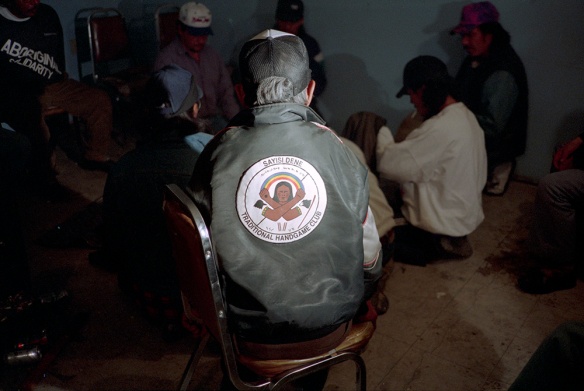
A colour photograph of the back of an elderly man wearing a “Sayisi Dene Traditional Handgame Club” jacket, watching a Dene Handgame match.

An Elder (Charlie Learjaw) observes a Dene Handgame match, Tadoule Lake, Manitoba, 1992–1993 (e011300421)

The team whose turn it is to hide their tokens will place their hands under a cloth covering (like a blanket or spare coats). They will move their token from hand to hand until they decide which hand to hide it in. Then, when they have chosen their hiding hand, they will take their fists out from under the cloth covering and face their opponents. Commonly, players keep their arms straight in front of them or they cross them over their chests; however, players also develop their own elaborate and unique positioning of their hands. Players will use facial gestures, body movements and sounds to try and confuse or “psyche out” the opposing captain, who is the one who will guess and signal to where they think each token is hidden.

A colour photograph of six men and one small child. The men are playing Dene Handgame. Three of the men are hitting individual caribou-skin hand drums with wooden drumsticks and singing.

Men drumming and playing Dene Handgame, Tadoule Lake, Manitoba, 1992–1993. Left to right: Brandon Cheekie, Peter Cheekie, Fred Duck, Jimmy Clipping, Ernie Bussidor, Tony Duck and Ray Ellis. (e011300426)

Before the captain makes the hand signal indicating where they think the tokens are hidden, they make a loud sound—a big clap, or they hit the floor with their hand—to let everyone know that they are ready to call. There are many different signals that can be used; however, there are four main ones that the Arctic Winter Games follow.

Once the captain reveals their hand signal, all the opposing players must then open the hand that the captain has indicated so everyone can see if the token is there. If the token is not there, meaning that the captain was wrong in their guess, the opposition player(s) must then show the other hand containing the object. Each time the captain is wrong in their guess, a stick is awarded to the opposing team. For example, if the captain guesses and makes one correct guess and three wrong guesses, the opposition will receive three sticks. The player who was guessed correctly is eliminated from the round, and now there are only three players remaining. This will continue until the captain has correctly guessed all of the players remaining, or until the opposing team wins all of the sticks. If the captain guesses all of the opposition players correctly, it is their team’s turn to hide their tokens and for the other team captain to try and guess which hands the tokens are in. The team to win all of the sticks wins the game.

A black-and-white composite photograph of about 16 boys, some standing, some kneeling on the ground. They are playing Dene Handgame. One young man is standing and hitting a caribou-skin hand drum with a wooden drumstick.

Gwichya Gwich’in men and boys playing Dene Handgame, Tsiigehtchic (Tsiigehtshik, formerly Arctic Red River), Northwest Territories, ca. 1930 (a102488)

Handgame tournaments

There are many small Dene Handgame tournaments happening all across the north all the time. My home community of Tadoule Lake, Manitoba, aims to play every Friday evening. There are also some very big Dene Handgame tournaments that happen a few times a year in various regions. Some of the prizes for winning teams are in the thousands of dollars!

Historically, there have been stories told about when people would play handgame—they would gamble goods such as firearms, bullets, axes, etc. I have even heard about men losing their wives to a game and having to win her back at another game!

Gender controversy in handgames

Children, both boys and girls, are taught how to play Dene Handgame at home and at handgame tournaments. In some regions, they are taught how to play at school as a part of physical education.

A colour photograph of a man, a teenage boy and a small child watching a Dene Handgame match. The man is hitting a caribou-skin hand drum with a wooden drumstick. The small child is mimicking the drumbeat with his own small hand drum.

A man (Peter Cheekie) hits a caribou-skin hand drum with a wooden drumstick while a teenage boy (Christopher Yassie) and a small child (Brandon Cheekie) watch a Dene Handgame match, Tadoule Lake, Manitoba, 1992–1993 (e011300429)

However, for adults, the sport is predominantly played by men. This is because some regions, particularly in the Northwest Territories, do not allow adult women to play. However, in the Yukon and in some northern Prairie provinces, women are not only allowed to play, they are encouraged and widely supported. This inclusion of women makes the games much larger and more fun to participate in and to observe. Tournaments will state whether they allow men’s teams only or mixed teams. There has only been one women’s handgame tournament (that I know of), which was held in Whitehorse, Yukon, in 2016. The inclusion of women to play handgames is a hot topic in the north. Some say that it is not “traditional” to allow women to play and that women “have too much power—so they would just win all the time.” Some communities do not even allow women to drum.

Others say that women played a long time ago, but that this changed with the imposition of Christianity. Some Christian missionaries actually banned the drum and playing Dene Handgames altogether. The drum in Dene culture is very important. It is spiritual and some Christian missionaries saw it as heathen and therefore unacceptable. They actually burned drums in some communities. Some people continued to play handgames in secret, but in other communities it only came back into practice in recent years. In one community in particular, I heard that handgames were not played for a long time, and it was the women who brought it back, encouraging the men and others to play again.

I think that in this day and age, it is not fair to exclude women from playing Dene Handgame, or to prevent them from drumming, for that matter. Gender dynamics change and shift within all cultures. I believe that more gender inclusion to compete in this fun pastime is a good, positive change for everyone.

I personally love to watch people play, but I much prefer to compete in the game myself, and I would love to see more women participate and have fun playing handgames as well.

Visit the Flickr Album for images of the Dene.


Angela Code is an archivist with the Listen, Hear Our Voices project at Library and Archives Canada.

Martha Louise Black: First Lady of the Yukon

By Katie Cholette

A signed and matted black-and-white photograph of a woman smiling, dated 1932.

Martha Louise Black, 1932. Photographer: Pierre Brunet (e011154526)

Hidden among the millions of items in the collection of Library and Archives Canada are a set of 10 floral postcards. Unassuming in size, and modest in subject matter, they were produced by an exceptional and adventurous woman named Martha Louise Black. Dubbed “First Lady of the Yukon,” and the second woman elected to Canada’s House of Commons, Martha Black was an astute businesswoman, an expert on the wildflowers of the Yukon and British Columbia, an author and lecturer, and the recipient of several honours. February 24, 2016 marks the 150th anniversary of her birth.

A colour reproduction of a plant with four purple flowers and one that has turned to seed. Centred at the bottom are the initials MLB and GB, and it is dated 1955.

“Pasque Flower” by Martha Louise Black. Photomechanical print, 1955. (e011154530)

When Martha was born in Chicago, Illinois, no one could have predicted what an exciting life she would lead. In 1898, at the age of 23, she left behind the comforts of her home in Chicago (and her first husband) to follow the Gold Rush to the Yukon. Financed by family money, Martha and her brother George crossed the Chilkoot Pass to the Yukon River. They continued to the Klondike where she staked gold mining claims. Her first stay in the Yukon lasted just over a year, but Martha had been bitten by the bug of the North. When she returned in 1901 she staked more claims, opened a successful sawmill and married her second husband, George Black. She would spend a large portion of the rest of her life living in the Yukon.

A colour reproduction of a plant with three yellow flowers with wide leafy bases. It is initialed MB and dated 1930.

“Cyprepedium, Large Yellow Lady Slipper” by Martha Louise Black. Photomechanical reproduction, 1955 (e011154531)

Martha and George built a life for themselves in the Yukon, where she raised three sons from her first marriage. George, a lawyer by profession, became the 7th Commissioner of the Yukon in 1912. Together, the Blacks played a central role in Dawson and later Whitehorse.

A colour reproduction showing a plant with small purple flowers and wide, deeply lobed leaves. It is initialed MB and dated 1930.

“Crane’s Bill – Wild Geranium” by Martha Louise Black. Photomechanical reproduction (e011154532)

Martha’s lifelong interest in botany flourished in the north. In 1909 she began collecting and pressing wildflowers, filling in the backgrounds with watercolour—a practice she called ‘artistic botany.’ Her works garnered praise, and over the next two summers she was commissioned to collect and mount wildflowers from the Rocky Mountains for exhibition at Canadian Pacific Railway stations and hotels. A series of her works were subsequently published as postcards, and she was made a fellow of the Royal
Geographical Society.

A colour reproduction showing a plant with long woody stems, closely clustered tiny pink flowers and small leaves. The print is initialed MB and dated 1920.

“Heather” by Martha Louise Black. Photomechanical reproduction (e011154538)

In 1935, at the age of 69, Martha was elected to the House of Commons. She served as Member of Parliament for the Yukon until 1940. In 1948 she was awarded the Order of the British Empire for her contributions to Yukon servicemen. Martha died in Whitehorse on October 31, 1957 at the age of 91.

Learn more about her life and work:

Written by Katie Cholette

Images of the North West Mounted Police in Yukon now on Flickr

The Klondike gold rush left an infrastructure of supply, support and governance that led to the continued development of the territory to such a great extent that Yukon became a Canadian territory on June 13, 1898. The North West Mounted Police stayed to maintain peace and order under their steady hands.

Go North, Sir!

In 1894, the Canadian government’s interest turned towards the Yukon. There were concerns about the influx of American citizens into the region as the new border was disputed in certain areas. In addition, there were mounting concerns over law and order, and the liquor trade among the resident miners.

Inspector Charles Constantine of the North West Mounted Police (NWMP) was dispatched to the Yukon to carry out law enforcement, border and tariff control, and to assess the policing needs of the territory. After four weeks of duty, Constantine returned south and submitted his report to the government recommending that a larger force of seasoned, robust and non-drinking constables between the ages of 22 and 32 years be sent to the Yukon to carry out border and law enforcement. It wasn’t until 1895 that a contingent of 20 constables under Inspector Constantine’s command finally set out from Regina towards the Alaskan border. They reached the town of Forty Mile and established Fort Constantine in July 1895. The year was marked by logging, enduring the elements and insects, and constructing their detachment building. Remarkably, crime during this time was rare.

Two black-and-white photos mounted on an album page depicting two groups of North West Mounted Police personnel outside in the snow

Fort Constantine detachment (now Forty Mile) on the Yukon River, 1895, the first North West Mounted Police group in the Yukon (MIKAN 3715394)

Things changed drastically in 1896. Gold was discovered near the Klondike River and news spread quickly. From a population of about 1,600 in the area, it swelled by tens of thousands by the summer of 1897 with prospectors, gamblers, speculators and those with criminal intent. A majority of these miners came from the United States. The NWMP commanded by Inspector Charles Constantine faced a challenge in policing the influx of miners streaming into the region from all directions. Customs posts were set up at the Chilkoot and White Pass summits and the collection of duties and tariffs began. Those miners with insufficient provisions to make it to Dawson City and survive the winter were turned back. By 1898, outnumbered, under-supplied and under-staffed, 51 NWMP members and 50 members of the Canadian militia maintained Canada’s sovereignty, and law and order at the border passes and in the mining areas in the Yukon.

Three North West Mounted Police constables in uniform standing at ease with clasped hands over the muzzles of their rifles.

North West Mounted Police in the Yukon, 1898–1899 (MIKAN 3379433)

The Klondike gold rush lasted into 1899 until gold was discovered in Alaska. The migration of fortune seekers turned their attention and travelled towards that state’s Nome region. However, the Klondike gold rush left an infrastructure of supply, support and governance that led to the continued development of the territory to such a great extent that the Yukon was made into a Canadian territory on June 13, 1898. The North West Mounted Police also stayed to maintain peace and order under their steady hands.

Black-and-white photograph of two men in North West Mounted Police uniform sitting on cots in a tent

North West Mounted Police in the Yukon, 1898–1910 (MIKAN 3407658)

A wide variety of documentation is available at Library and Archives Canada (LAC) related to the North West Mounted Police, the Klondike gold rush, and their time in the territory. You may start your initial research in Charles Constantine‘s fond using Archives Search. A general search using his name will provide further records from the Department of Justice.

Try searching with some of these keywords to get more records from the era:

Bennett Lake / Lake Bennett
Chilkoot Pass
Dawson City Yukon
Dyea
Forty Mile
Gold rush
Klondike River
Skagway
White Pass
Yukon River

Related sites