Métis Nation river lot plans

On the left of the graphic, Tatânga Mânî [Chief Walking Buffalo] [George McLean] in traditional regalia on horse. In the middle, Iggi and girl engaging in a “kunik”, a traditional greeting in Inuit culture. On the right, Maxime Marion, a Métis guide stands holding a rifle. In the background, there is a map of Upper and Lower Canada, and text from the Red River Settlement collection.

By William Benoit

An oil painting depicting a person on a Red River cart being pulled by an ox on a dirt road. In the background, there is a small white house and two other small buildings.
“Manitobah” settler’s house and Red River cart (c013965k)

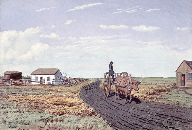
Library and Archives Canada holds plans produced by the Canadian government of existing Métis river lots. These were required by the Manitoba Act and the transfer of Rupert’s Land and the North-Western Territory. These river lot plans are important pieces in understanding the Métis Nation. The plans are invaluable to the entire Métis Nation because they show where many Métis ancestors lived before Canada’s acquisition of the region.

A large map showing narrow rectangle river lots and the names of the owners of the lots, written in red ink. At the top of the map is a compass, indicating north.
Plan of river lots in the Parish of Lorette, Province of Manitoba; surveyed by (signed) G. McPhillips, Deputy Surveyor; examined and certified by (signed) A.H. Whitcher, Inspector of Surveys; Dominion Lands Survey Office, Winnipeg, February 16, 1878 (e011213852)

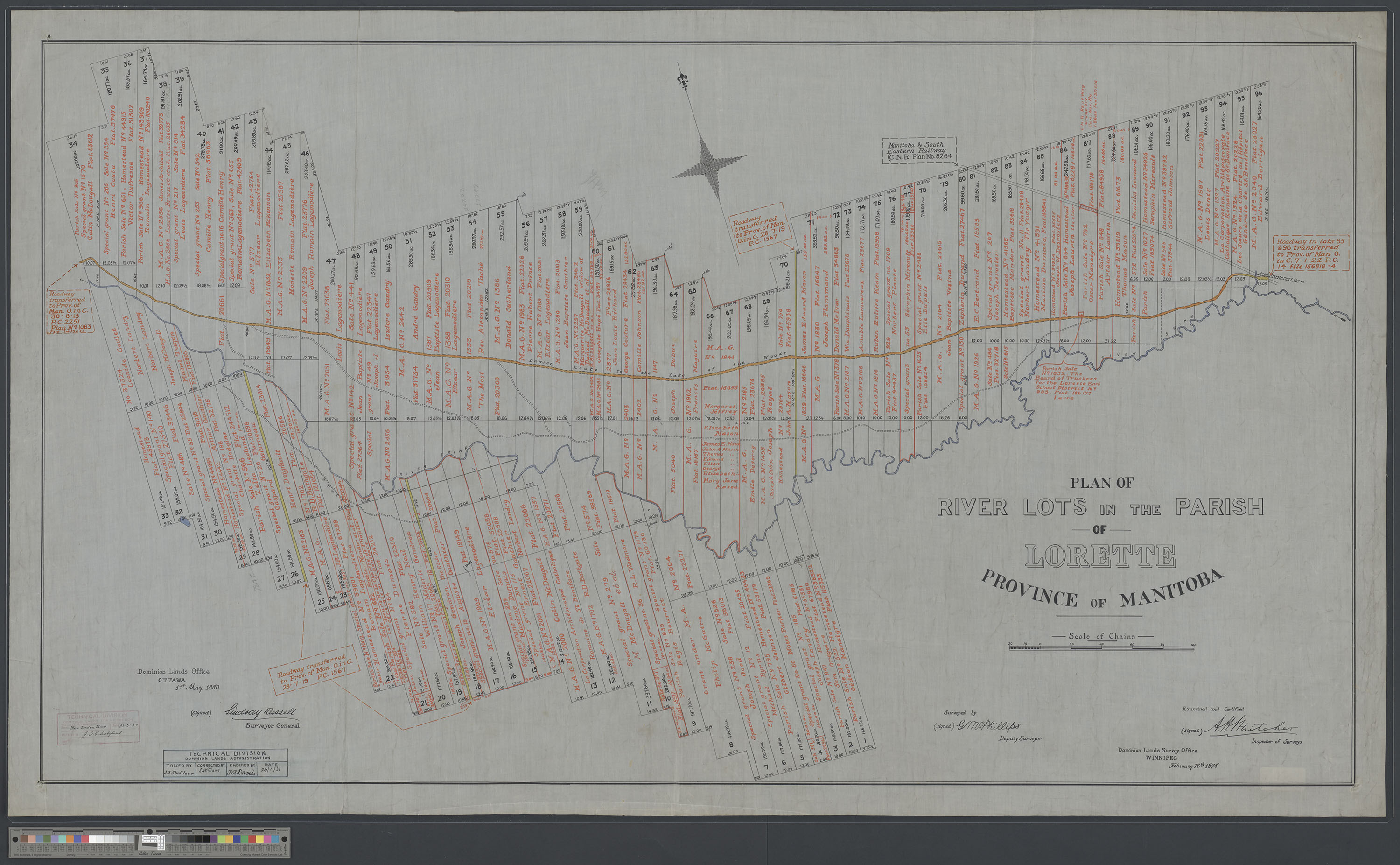
The Métis created settlements across the Métis Nation Homeland. The cradle of this homeland was the Red River Settlement. By 1869, there were 12,000 inhabitants there, of which 10,000 were Métis. Censuses recorded that 5,000 to 7,000 of the Métis were children.

King Charles II granted a trading monopoly over the territory known as Rupert’s Land to the Hudson’s Bay Company in 1670. This territory comprised all of the land watered by rivers flowing into Hudson Bay. These areas included what is now the whole of Manitoba, most of Saskatchewan, southern Alberta, southern Nunavut, and northern parts of Ontario and Quebec. In the United States, Rupert’s Land included parts of Minnesota, North Dakota, South Dakota and Montana.

On November 19, 1869, the Hudson’s Bay Company surrendered Rupert’s Land and the North-Western Territory under its letters patent to the British Crown. By Order-in-Council dated June 23, 1870, the British government admitted the territory to Canada, under section 146 of the British North America Act, 1867 (now the Constitution Act, 1867), effective July 15, 1870. This was subject to the making of treaties with the sovereign Aboriginal peoples.

The Métis in Red River were apprehensive about the transfer and were concerned that it would threaten their way of life. They were unsure about the status of their land rights and their democratic rights under the proposed new regime. The federal government sent out survey parties prior to the transfer of Rupert’s Land. Their surveys were to be carried out in accordance with the Ontario style of survey, in squares, instead of the system of long, narrow lots with river frontage used by the Métis. The new system cut across properties already in existence. On October 11, 1869, proclaiming that the federal government had no right to act without permission, a group of Métis stopped a crew of surveyors on a Métis river lot. This challenge to the way that the Government of Canada conducted these activities served notice that the residents would need to be consulted and have their rights guaranteed.

In November 1869, the Métis seized Upper Fort Garry and established a provisional government. The Métis government drafted demands that Canada had to satisfy before they would accept incorporation into Canada. The result was the Manitoba Act. The arrangement made for the Manitoba Act is one of the deals (or compacts) that led to Canada’s expansion westward.

Under the Manitoba Act, the intention was to respect the concern of the Métis for their lands. This took two forms: a provision to protect the existing land holdings of the 3,000 Métis adult landholders (section 32), and a provision to give Métis children and families a “head start” in the province with a land grant of 1.4 million acres (section 31).

In post-Confederation Manitoba, the position of the Métis deteriorated. New settlers from Ontario were hostile for racist, religious and cultural reasons. Some Métis elders, over generations, described that period as a “Reign of Terror” against the Métis people. The distribution of land under section 31 was slow and fraught with corruption. As a result, many Métis sold their promised interests in the land and moved outside of the province that they had helped to create. The 1874 plan of river lots in the parishes of St. Norbert and St. Vital is included below as an example that depicts the early stages of the Métis diaspora. It also documents land speculation by individuals such as Donald Smith of national railway fame, and the Roman Catholic clergy’s attempt to create and maintain a French-speaking enclave in advance of the oncoming wave of immigration.

The Métis river lot maps are very important documents today because they can be used to identify and register citizens of the Métis Nation.

A large map showing narrow rectangle river lots and the names of the owners of the lots, written in red ink. A railroad and a river are shown on the map.
Plan of river lots in the parishes of St. Norbert and St. Vital, Province of Manitoba (e011205909)

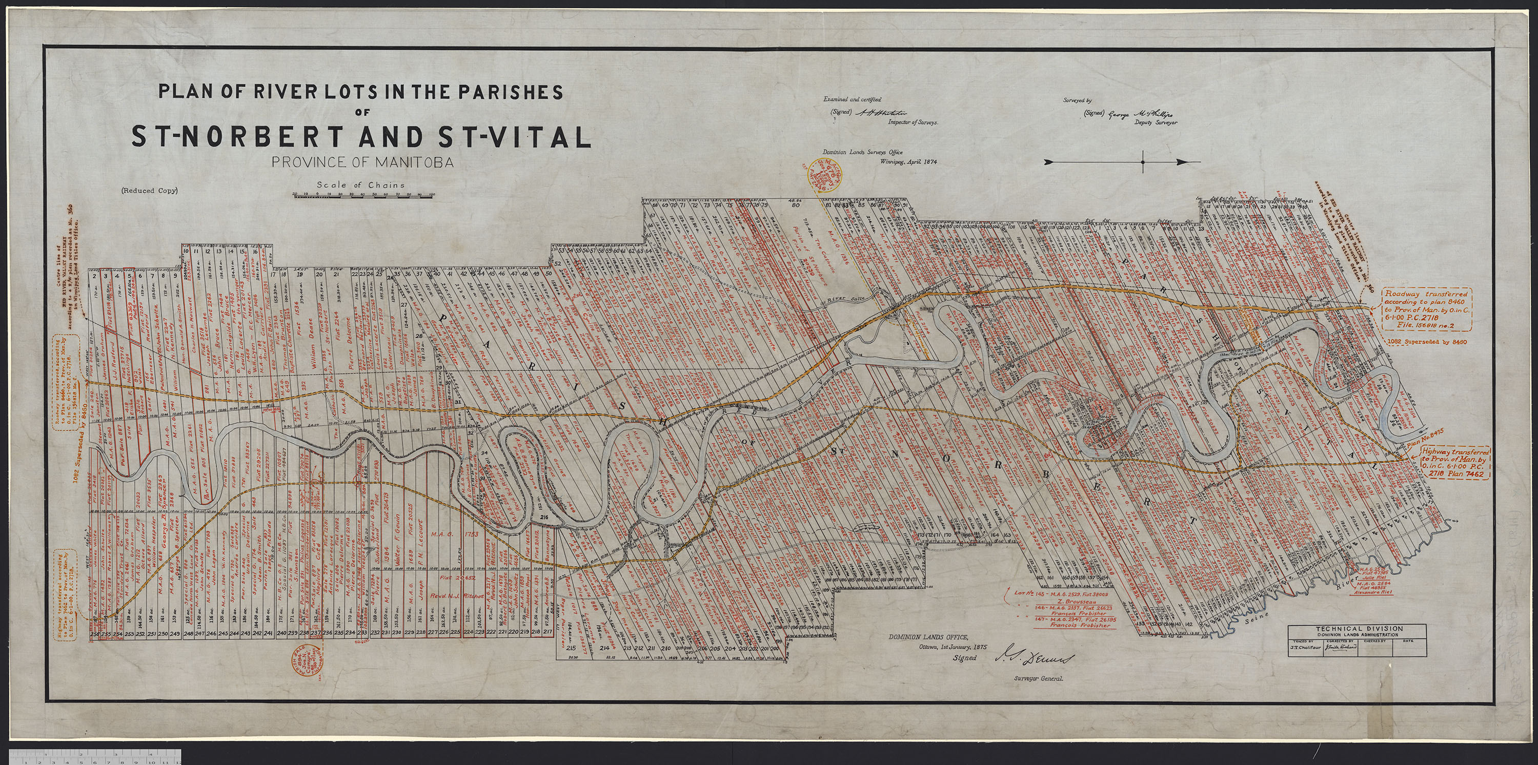
Visit the Flickr album for images of Métis Nation river lot plans.


William Benoit is the Advisor for Internal Indigenous Engagement in the Office of the Deputy Librarian and Archivist of Canada at Library and Archives Canada.

6 thoughts on “Métis Nation river lot plans

    • That’s a good idea! When you are doing research in Collection Search, you can transcribe the records using Co-Lab. In the image viewer, you will see one of two options to contribute using Co-Lab:
      If an image has already had crowdsourcing enabled, you can click the button labelled “Contribute” and continue adding your information.
      If an image has not yet been enabled for crowdsourcing, once you click on “Contribute” you will see a button labelled “Enable this image for Co-Lab contributions.” After clicking on it, you will be able to answer a few short questions about whether the image needs transcription (does it contain any text within the image?), the language of the text, and what type of media best describes it, in order to help define what types of contributions will be collected.

      Happy transcribing!

  1. The map is excellent thank you. My ancestor got land in the Metis Nation Riverlot lands in Lorette. They are Metis and the head of the family along with every on of his children received land and are on the map. They are all listed under the records for land grants. Why did some Metis receive scrips and others applied for land grants.

Leave a Reply

Fill in your details below or click an icon to log in:

WordPress.com Logo

You are commenting using your WordPress.com account. Log Out /  Change )

Facebook photo

You are commenting using your Facebook account. Log Out /  Change )

Connecting to %s

This site uses Akismet to reduce spam. Learn how your comment data is processed.