The 1931 Census: a reading list

Banner for The 1931 Census series.

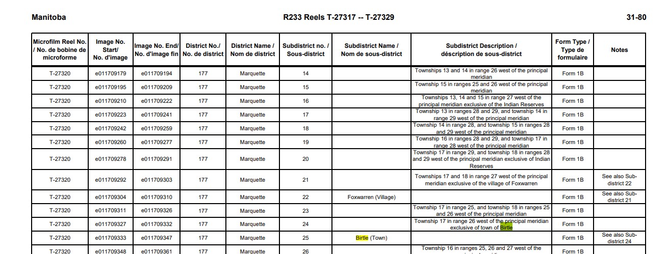
In preparation for the release of the 1931 Census returns, some of us at Library and Archives Canada have done a lot of reading. We thought we’d share a few census publications that piqued our interest.

Instructions to Commissioners and Enumerators, Seventh Census of Canada, 1931, and Instructions to Enumerators, Census of the Northwest Territories [and certain other northern areas], 1931

Ready to read cursive handwriting? Although these instructions don’t help us decipher cursive (alas!), they do help us understand some abbreviations used in the census returns. Enumerators were instructed to use certain abbreviations, such as “(ab)” for “absent.” The instructions also detail what enumerators were told to record and how; for instance, who was to be considered part of the family for the purpose of enumeration. Sara Chatfield’s recent blog, “How to conduct a census – in 1931,” highlights elements new to the instructions in 1931.

Note that the Dominion Bureau of Statistics issued separate Instructions to Enumerators for the 1931 Census of the Northwest Territories, certain parts of Yukon, eastern shore of Hudson Bay north of Great Whale River, and southern shore of Hudson Strait and Ungava Bay. This separate set of instructions was issued because the census of population in these areas was recorded using a separate form (Form I-N.W.T.), and also because the census in these northern areas was taken earlier—at any convenient time between October 1, 1930, and June 1, 1931, rather than as of June 1, 1931—for logistical reasons.

A printed page with titles and a crest.

Screenshot of cover page of Instructions to Enumerators, Census of the Northwest Territories [and certain other northern areas], 1931 (Library and Archives Canada/CS98-1931I-1-eng, title page)

The Administrative Report on the Seventh Census of Canada (Seventh Census of Canada, 1931, Volume I, Summary)

The Administrative Report on the Seventh Census of Canada provides good reading for those of us who are curious about what the Dominion Bureau of Statistics did with the handwritten census returns after they arrived in Ottawa from across the country.

The “New Census Machines—Sorter-Tabulator and Verifier” section (pages 58–62) provides insight into how the information in the handwritten census returns was processed at the Dominion Bureau of Statistics. This section explains what the Bureau did with the census returns that we preserve at Library and Archives Canada. For the purposes of sorting and tabulating results, Bureau employees punched a general card for each individual listed in the census returns, meaning that the Bureau must have punched over 10 million general cards. Can you decipher the information recorded on the following general card? For an answer, see page 59 of the report.

A rectangular card with 20 irregular divisions, each featuring numbers or letters, some of which are punched, and numbers 1 through 24 along the bottom of the card.

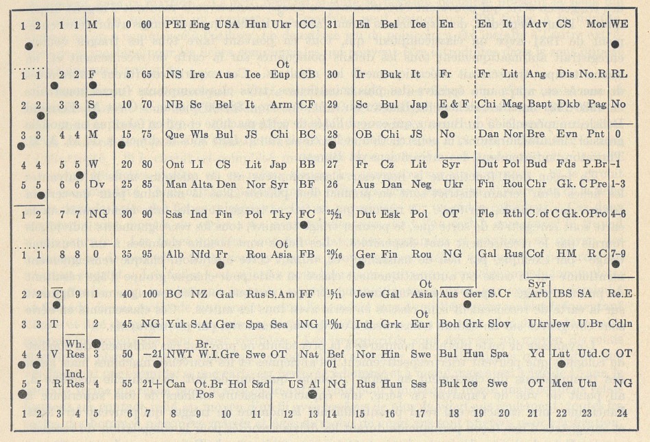
A general card used by the Dominion Bureau of Statistics for sorting and tabulating activities during the 1931 Census (OCLC 796971519)

A second type of card, the family and occupation card, “was used for the purpose of compiling statistics relating to the Canadian home and family” (page 59).

A rectangular, 80-column Hollerith Card (punch card), featuring column headers such as household, private family, personal, occupations and earnings, and unemployment.

A family and occupation card used by the Dominion Bureau of Statistics for sorting and tabulating activities during the 1931 Census (OCLC 796971519)

Sorting, counting and recording proceeded mechanically. The Dominion Bureau of Statistics had developed, in-house, a new sorter-tabulator for the 1931 Census, increasing possibilities for cross-analysis “several thousands of times” (page 60). The Administrative Report describes how this new sorter-tabulator worked and features a photograph—admittedly grainy—of the machine as well as of others, such as the verifier and the gang-puncher, on pages 72–73.

A black-and-white photograph of a large, high-ceilinged room in which approximately 80 employees (mostly women) sit at machines, punching in information recorded on a large roll in front of each machine. The employees sit in six columns, each of about a dozen rows, facing the photographer. The rows of employees are so numerous that they seem to extend into the distance. In the foreground, drawers of cards are lined up carefully on desks. In the middle ground, a woman stands observing a woman sitting at a punching machine. At the far right and in the background, additional personnel (mostly men) sit at additional rows of desks or are walking about.

Employees working on the 1931 Census in the punching room at the Dominion Bureau of Statistics (from Statistics Canada’s 2018 online HTML version of Standing on the shoulders of giants—History of Statistics Canada: 1970 to 2008, by Margaret Morris)

Another section in the Administrative Report, “The Field Work” (pages 51–56), describes the task of enumerating each person within the borders of Canada at that time. Additionally, in this section, the Bureau reports not only the number of enumerators involved but also the enumerators’ regular occupations. Among the 13,886 people working temporarily as enumerators, their regular occupations were most frequently the following:

A screenshot of text from a printed document.

A listing of the “most numerously represented occupations” of 1931 Census enumerators, from the Administrative Report on the Seventh Census of Canada (OCLC 796971519)

The Administrative Report was republished as Part I of the Dominion Bureau of Statistics report on the Seventh Census of Canada, 1931, Volume I, Summary (Ottawa, King’s Printer: 1936).

“Radio sets in Canada, 1931”

New for the census of population in 1931 was a question about radio sets. The Dominion Bureau of Statistics 1932 bulletin “Radio sets in Canada, 1931” provided a preliminary count of the result. The bulletin tabulated radio sets by province, census division and urban centre of more than 5,000. People in Montréal—listed as the biggest urban centre, with a population of 818,577—owned a total of 70,164 radio sets. However, Toronto—listed as the second-biggest urban centre, with a population of 631,207—reported the highest total of radio sets owned: 91,656.

A photograph of a man in a cardigan with a pipe in his mouth sitting at a typewriter; his surroundings include a bookshelf, a lantern and a radio.

A radio features in the background of this January 1931 photograph of Richard Finnie typing notes in Kugluktuk, Nunavut (a100695)

Not all of our reading was pleasant. Reading through publications from the 1930s is a reminder of the varied ways in which racism, sexism and colonialism were manifest at that time. Those attitudes shaped the taking of the census and have had enduring legacies into the present.

We’ve mentioned just a few examples of what we’ve been reading from among the many publications that preceded or resulted from the 1931 Census of Population. Generally speaking, the Dominion Bureau of Statistics released preliminary counts and summaries as soon as possible after the 1931 Census, as it did with “Radio sets in Canada, 1931.” The Bureau subsequently published definitive findings and analyses in the multi-volume official report of the 1931 Census. Statistics were published in volumes I through XI during the years 1933 to 1936, and additional thematic analyses on topics such as “housing in Canada” and the “lengthened dependency of youth” were published as volumes XII and XIII in 1942. These publications and many more are found in the library collections at Library and Archives Canada. Many such publications have been digitized by Statistics Canada and made available on the Internet Archive and the Government of Canada Publications catalogue.

If you’re interested, we invite you to browse some of the published heritage from the 1931 Census of Canada. And good luck interpreting cursive handwriting in the census returns!

Puzzling through 1931 Census sub-districts – Part 2

This article contains historical language and content that some may consider offensive, such as language used to refer to racial, ethnic and cultural groups. Please see our historical language advisory for more information.

This is Part 2 of the blog series Puzzling through 1931 Census sub-districts. If not done already, you may want to read Part 1, as it provides tools to help identify the census district that would have included your place of interest in 1931.

As a reminder from Part 1, to find the census returns for a place of interest, we generally need to narrow down, in order, the:

  1. province or territory;
  2. census district or federal electoral district; and
  3. census sub-district

that would have included the place of interest in 1931.

In this blog post, we go over the last step.

STEP 3. Determining the census sub-district

Each 1931 Census district was divided into multiple sub-districts – anywhere from three to 148 – for the purpose of enumeration. The majority of census districts were divided into at least 50 sub-districts.

The hitch is that no maps of 1931 Census sub-district boundaries are known to still exist. Figuring out in which census sub-district one’s place of interest was enumerated requires using one of the following tools:

  1. Street indexes (for 11 major cities)
  2. Finding aid for “Indian Reserves” (First Nations)
  3. Written descriptions of sub-district boundaries.

If your place of interest was in neither a major city nor a First Nations Reserve in 1931, skip directly to the last tool, the written descriptions of sub-district boundaries.

Tool 1: Street indexes

Indexes are available for Halifax (N.S.), Saint John (N.B.), Quebec (Que.), Montréal (Que.), Toronto (Ont.), Hamilton (Ont.), London (Ont.), Winnipeg (Man.), Edmonton (Alta.), Calgary (Alta.) and Vancouver (B.C.). Street indexes list street names and indicate in which census district and sub-district(s) those streets were enumerated.

The indexes for Hamilton and Calgary are specific to the 1931 Census. The indexes for the remaining cities cover multiple census years. In those indexes, for the purposes of locating district numbers for the 1931 Census, consider only entries beginning with “31.” The numbers that follow are the district and sub-district numbers, respectively, for 1931. So, for instance, if we are looking for a place of interest on Montréal’s Chemin de la Côte-des-Neiges in the census district of Mont-Royal (Census District no. 84), we find:

Typewritten entries for “Côte des Neiges” from the Montréal Street Index.

Excerpt from the Montréal Street Index (Finding Aid 31–80)

The numbers in the first line depicted above – “31–84–39, 40, 41, 43, 44, 45” – indicate that, in 1931, Chemin de la Côte-des-Neiges was enumerated in Census District no. 84, in census sub-districts 39 through 41 and 43 through 45.

Note: the street names featured in the indexes are historical; in other words, they are as written by the enumerator at the time, generally speaking.

Beware: the same street may have had its name written in multiple ways and thus appear in separate parts of the alphabetically ordered street index. In the case of Montréal’s Chemin de la CôtedesNeiges, entries are spread across three separate areas of the Montréal index, with the street name written as “Côte-des-Neiges,” “Côte des Neiges” and “Cote des Neiges.”

Tool 2: Finding aid for “Indian Reserves” (First Nations)

A listing of reserves by 1931 Census district and sub-district is available. This unverified finding aid could be useful if your place of interest was (in) a First Nations Reserve in 1931. We are currently working to adapt this pre-existing finding aid to include respectful terminology.

Tool 3: Written descriptions of sub-district boundaries

Written descriptions of sub-district boundaries were compiled by the Dominion Bureau of Statistics. These descriptions have been transcribed into finding aids for each province or territory: P.E.I., N.S., N.B., Que., Ont., Man., Sask., Alta., B.C., Y.T., N.T.

Note: the transcription of sub-district descriptions for select major cities may be forthcoming.

You may choose to begin with a keyword search related to your place of interest in the finding aid for a province or territory. For example, searching the Manitoba sub-district description finding aid for “Birtle” yields three results within the census district “Marquette”: sub-district 25 for “Birtle (Town)”; sub-district 24 for “Township 17 in range 26 west of the principal meridian exclusive of town of Birtle”; and sub-district 63 for the residential school of the same name. Alternatively, you may choose to navigate to a particular census district (like “Marquette”), then browse all sub-district descriptions within that census district.

An excerpt of a finding aid for Manitoba. The excerpt features several sub-district names and descriptions for within the Census District “Marquette.” Two instances of the word “Birtle” are highlighted.

Excerpt from the Finding Aid for the 1931 Census Returns for Manitoba (Finding Aid 31–80)

The characterization of census sub-districts varies tremendously. The descriptions may refer to townships, municipalities, city wards, polling divisions, reserves, parishes, meridians, ranges, lots, roads, islands, rivers, etc. Making sense of the descriptions may require consulting local maps from the era or learning about the local, provincial or other federal geographies leveraged for the purposes of the 1931 Census (e.g., municipal boundaries may have been established in contemporary provincial law).

Sometimes the sub-district descriptions do not themselves allow us to narrow things down to a single sub-district. To illustrate what we mean by that, we can look at sub-district descriptions for the census district of Mont-Royal.

A typewritten card listing sub-district ranges for different parts of the Mont-Royal district in Quebec, 1931.

The Dominion Bureau of Statistics’ working description of sub-districts in District 84, Mont-Royal (from material accompanying the transfer of the 1931 Census returns to Library and Archives Canada). Library and Archives Canada/Statistics Canada fonds/District 84, Mont-Royal, Quebec, 1931

The sub-district descriptions for Mont-Royal create a situation in which it is challenging to identify a single sub-district of relevance. If you face this situation, you then have two options:

  1. flip through the census returns for all relevant sub-districts; or
  2. narrow things down using other working tools, such as city directories, which might list wards, or using additional tools such as a Street Index, which is likely the best approach in the case of Montréal.

Sometimes additional sub-district descriptions feature on the title card preceding the sub-district’s census returns. Scans of the original Dominion Bureau of Statistics’ working descriptions of sub-districts are available online and, though cumbersome, may be used for troubleshooting purposes. To view these scans, go to the archival description for the 1931 Census returns in Collections Search, toggle open the details, then toggle open the finding aid section and scroll down.

Additional resources

  • To learn about the system of townships, ranges and meridians used in the three prairie provinces and the railway belt of British Columbia, consult the section titled Western Canada Land System Description on the homepage for our Land Grants of Western Canada database.
  • The blog post “Finding Royalton: Searching the 1921 Census” describes how a staff member locates small rural hamlets or unincorporated villages. It offers insights and ideas about how to overcome stalemates.
  • If you had already found your place of interest among the census returns from the 1921 Census of Canada or 1926 Census of Prairie Provinces, consider viewing the sub-district description in Census Search for that earlier census year. It might assist you in navigating the sub-district descriptions for the 1931 Census.

Again, wishing us all the best in our searches for people and places of the past.

As always, don’t forget that we can help: reach out to our genealogy team by using our Ask genealogy a question online form.

Puzzling through 1931 Census sub-districts – Part 1

This article contains historical language and content that some may consider offensive, such as language used to refer to racial, ethnic and cultural groups. Please see our historical language advisory for more information.

Sometimes we researchers – including staff at Library and Archives Canada – need to navigate the archived census returns according to how the returns themselves are organized: by census sub-district. We don’t usually navigate census returns this way, since we have Census Search, our one-stop-shop database for genealogy. Once every few years, navigation by sub-district is necessary while we work to incorporate new census records into our database.

When we begin our work – and it is often tricky work – of navigating the archived census returns geographically, we often use a “step-wise” approach to narrow them down by

  1. province or territory;
  2. census district or federal electoral district; and
  3. census sub-district

that would have included our place of interest. We use this approach to be more efficient when searching, because there are so many census sub-districts involved: 15,167 sub-districts in the 1931 Census, to be exact.

This blog series offers five tools to help you find your place of interest among the census returns. Get ready to learn how to navigate the 1931 Census returns geographically!

Map of Canada (without some northern regions) in which each province and territory is a different colour. Major railway lines are indicated with a thick black line. Major sea shipping routes are indicated with a dotted red line featuring the name of the two cities linked, and the mileage between them.

“Map of the Dominion of Canada (Exclusive of Northern Regions)” featured in the Dominion Bureau of Statistics The Canada Year Book, 1931 (OCLC 300543070)

STEP 1. Determining the province or territory

Reminders:

  • The Northwest Territories had different boundaries in 1931 than it does today.
  • Newfoundland and Labrador became a province of Canada in 1949, and so its population is not enumerated in the Seventh Census of Canada. (Information about the separate censuses taken of Newfoundland and Labrador in 1921, 1935 and 1945 can be found on our Newfoundland and Labrador: Census and Enumerations web page.)
Green and white one-cent Newfoundland postage stamp.

Map of Newfoundland and Labrador, July 1931, one-cent Newfoundland stamp, Perkins, Bacon & Company, © Canada Post (s001670k)

STEP 2. Determining the 1931 Census district

Lucky scenarios that let you skip Step 2

There are a few scenarios in which you may go directly to Step 3 (forthcoming in the next blog post); these scenarios include when your place of interest is

  • located on a street in a major city for which Street Indexes have been prepared; or
  • an “Indian Reserve” (First Nations) listed in the relevant finding aid; or
  • included in the description* of sub-district boundaries.

*You can try a quick keyword search of the province-specific finding aids for sub-district descriptions: P.E.I. finding aid, N.S. finding aid, N.B. finding aid, Que. finding aid, Ont. finding aid, Man. finding aid, Sask. finding aid, Alta. finding aid and B.C. finding aid.

If your place of interest is in the territories, note that

  • Yukon was census district no. 241; and
  • the Northwest Territories was census district no. 242,

and go directly to Step 3 (in the next blog post).

If you cannot skip Step 2, your investigation begins with picking your preferred tool.

At Library and Archives Canada, we mainly use five online tools to help us determine in which 1931 Census district our place of interest was enumerated. The online tool that we choose is often a matter of personal preference. Some of us like lists; some of us like scrolling through old maps; some of us like navigating from the present, going backward in time; some of us prefer a quick database search; some of us know county names.

Tool 1: 1931 Census Maps research tool

This research tool lists 1931 Census districts. It also features links to maps approximating each census district. This tool is best used in a situation in which one or two census district names jump out as being likely candidates.

Note: This research tool does not include the census districts of the Northwest Territories, the District of Patricia (northern Ontario) or Unorganized (northern) Quebec.

Tool 2: Atlas of federal electoral district maps, 1924

To get a general sense of the 1931 Census district boundaries within each province, turn to the province-specific overviews in the digitized, 12-volume atlas prepared by the Department of the Interior of federal electoral district maps, 1924.

  • Why federal electoral district? The boundaries of the 1931 Census districts nearly always match the boundaries of a federal electoral district as established by the Representation Act of 1924. (Stay tuned to learn why in our upcoming blog, “Why are the 1931 Census records organized geographically?”)
A map depicting federal electoral districts in British Columbia. The boundaries are indicated by thick blue lines, and the names are indicated in blue type. The map was prepared on a base map of British Columbia featuring mountain ranges, rivers and cities. Additional detail is provided in two inset outline maps, for Vancouver and district, and for the City of Victoria.

“Map of British Columbia showing the federal electoral districts, 1924” from an atlas of federal electoral district maps, 1924, prepared by the Department of the Interior (e011315905)

You can flip through quicker-loading thumbnail-sized images of the atlas maps; the province-specific ones are the first 11 thumbnail images of the atlas. Should you need a higher-resolution image, use the overviews: P.E.I. overview, N.S. overview, N.B. overview, Que. overview, Ont. overview, Man. overview, Sask. overview, southern Alta. overview, northern Alta. overview and B.C. overview. The digitized overview maps are hard to read in some instances, but if they are decipherable for your place of interest, they may help to identify the federal electoral district, and therefore (typically) the census district, of relevance. Should the overview map be too difficult to read, consider browsing through thumbnail images for the entire province volume in the Federal electoral district maps, 1924 atlas. You can consult the thumbnail image range for each provincial atlas in the 1931 Census Maps research tool (“digitized image item no.”). That research tool also provides links to higher-resolution images of individual maps.

Should you want a more detailed sense of the boundaries of a particular federal electoral district (and therefore, usually, census district) in a province or Yukon, consult the map for that individual federal electoral district in the digitized atlas. You can navigate to a higher-resolution image of any particular electoral district in the atlas using the 1931 Census Maps research tool.

A map page from a previously bound atlas featuring a black-and-white map of the electoral district of Mount Royal and a paragraph describing the district.

Electoral district map for the Mont-Royal electoral district in Quebec, from an atlas of federal electoral district maps, 1924 (e011315941)

Note: If you are looking for a place in northern Ontario or Quebec, note that the District of Patricia was census district no. 244, and areas of northern Quebec were enumerated as census district no. 245.

Tool 3: Library of Parliament online list of ridings

This online resource lets you do the following:

  • View a listing of federal ridings as they existed at the time of the 1931 Census. Consult the Library of Parliament’s online resource “Elections and Candidates” for the 17th Parliament, and view the constituency titles listed for the general election of July 28, 1930.
  • Navigate the list of ridings represented in the House of Commons from 1867 to today. You can choose to:
        • Navigate from the current federal riding, going backward in time to 1931. (Note: You can find a current federal riding using Elections Canada’s Voter Information Service database.) From the list of current federal ridings, click on a riding name. From the page for that riding, click through to previous ridings. When you get to a riding that existed in 1931, look for its description under the Information subheader “S.C. 1924, c.63” (referring to the Representation Act of 1924); or
        • Search for historical ridings. On the Library of Parliament landing page for the list of ridings, in the top-right corner of the table, clear the default “currently active” filter by choosing “select all” for active and inactive ridings.

There is usually a very close match between the federal electoral riding that existed in 1931 and the 1931 Census district. You can choose to double-check the correspondence between a federal electoral riding and a census district using the 1931 Census Maps research tool.

Tool 4: Post Offices and Postmasters database

If your place of interest was likely to have had a post office in 1931, investigate what is available in our Post Offices and Postmasters database, which includes electoral districts. Try keyword searching.

Tool 5: Map of counties (and the like)

Try navigating by provincially established county (or the like). Only use this option if your place of interest is in Ontario, Quebec or an Atlantic province.

  • Why counties? Ontario and eastward, provincially established counties (and the like) often, but not always, informed the shape of census districts in the early 20th century. Sometimes counties (and the like) were grouped into one census district, and sometimes counties were split into several census districts. Either way, many county names featured in census district names.
An outline map of Canada, its provinces and Yukon. Each province is then divided further, with each division numbered.

“Index map showing the counties and census divisions as organized at the census of 1931,” in the Dominion Bureau of Statistics 1937 Illiteracy and School Attendance, by Murdock C. MacLean, p. 16 (OCLC 1007622268)

First, identify the county name. To do that, consult the “key to index map” provided below or this very high-level index map of counties (if you need to zoom in). Then, pay attention to the county name (numbers are not important for our purpose). If you identify a county name, search by keyword for that county name in 1931 Census Maps research tool. If you get a unique hit in the list of 1931 Census district names, you are now ready to go to Step 3 (in the next blog post). You can always double-check if you have the right census district by using that same research tool to consult the relevant map. If the county index map is tricky to navigate for your place of interest in Ontario or eastward, don’t bother with the county index.

  • Beware: The county map above does not help us to navigate the census districts used to organize the census returns from the Prairie provinces or British Columbia.
  • Beware also: Census districts used to collect the census returns were sometimes different than the census divisions used to tabulate and publish the census results.
A typed table listing county names for Prince Edward Island, Nova Scotia, New Brunswick, Quebec and Ontario, as well as the number on the map corresponding to that county.

Counties, not census districts! Key to Index Map, from the Dominion Bureau of Statistics 1937 Illiteracy and School Attendance, by Murdock C. MacLean, p. 16 (OCLC 1007622268)

Don’t forget that we can help! Reach out to our genealogy team by using our Ask genealogy a question online form.

Stay tuned for Part 2 of this blog. In the meantime, we wish everyone the best in all of our searches for people and places of the past!

Researching early census records

Library and Archives Canada (LAC) is pleased to announce the launch of an expanded version of one of our most popular research guides: Finding Aid 300: Other census and related documents (1640 to 1945).

This tool is a comprehensive guide to early census and related records found at LAC, with references mainly dating from 1640 to the 1800s. There are also some records from the 1900s, including Newfoundland and Labrador from 1921 to 1945.

New to this version of Finding Aid 300 are links to digitized images of most of the documents. Researchers can access numerous digitized records relating to Acadia, Nova Scotia, New Brunswick, Newfoundland and Labrador, Prince Edward Island, Quebec, Ontario, Manitoba, and British Columbia.

We also invite you to visit our updated Censuses page, which includes links to our databases of census returns (1825 to 1921) and other resources.