Join us in celebrating our 1,000th blog post!

The Library and Archives Canada (LAC) Discover Blog has hit an important milestone! We have published 1,000 blog posts! For the past eight years, the blog has showcased our amazing documentary heritage collection, let researchers know what we are working on, and answered frequently asked questions.

To celebrate this momentous occasion, we are looking back at some of our most popular blog posts.

1940 National Registration File

A typed, two-column questionnaire titled “Dominion of Canada—National Registration Card for Women” with “For Information Only” written diagonally across the middle.

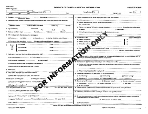
Sample of a questionnaire for women, courtesy of Statistics Canada.

Year after year, this early blog post has consistently been at the top of our list of views and comments. It is not surprising that a genealogy themed post took the top place; what is surprising is that the 1940 National Registration File is not held at LAC, but can be found at Statistics Canada. Either way, it is a great resource and very useful to genealogists across the country.

Want to read more blog posts about genealogy at LAC? Try the post, Top three genealogy questions.

Do you have Indigenous ancestry? The census might tell you

A woman and a man sit in the grass with their two young children in front of a canvas tent.

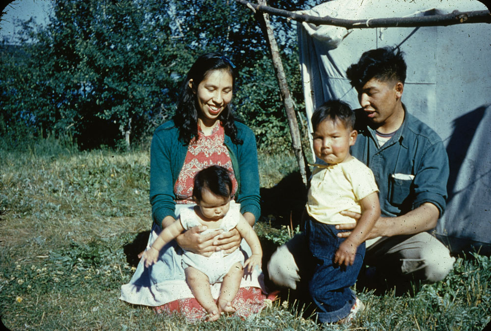
Indigenous man and woman [Alfred and Therese Billette] seated on the grass with two children [Rose and Gordon] outside their tent (e010999168).

Another popular post is the 2016 blog explaining how Canadian censuses could help you examine your past and research your unknown ancestral lineage to Indigenous heritage. Canadians might search for their Indigenous heritage to resolve questions of self-identity, or to know if they may participate with Indigenous organizations, or get Indigenous benefits.

Want to read more blog posts on how to research your Indigenous heritage? Try one of these posts, Department of Indian Affairs and Northern Development records: Estate files or The Inuit: Disc numbers and Project Surname.

The Grey Fox: Legendary train robber and prison escapee Bill Miner

Poster showing a photograph of Bill Miner, announcing a $500 reward for his recapture, listing details as to his escape, and describing his physical characteristics.

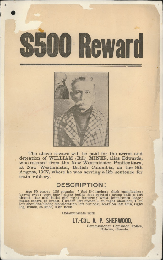
Reward notice for the recapture of Bill Miner that was sent to police departments, publications and private detective agencies (e011201060-210-v8).

This exciting post tells the story of Bill Miner, who was nicknamed “The Grey Fox” and “The Gentleman Bandit.” Bill Miner was a legendary criminal on both sides of the Canada–U.S. border. Although he committed dozens of robberies and escaped from multiple prisons, many saw him as a generous folk hero who targeted exploitative corporations only. LAC holds many documents, publications, sound and video recordings, and other materials relating to Miner, and hundreds of these documents are now available on our website as a Co-Lab crowdsourcing challenge.

Want to learn more about records from the B.C. Penitentiary system? Try the post, British Columbia Penitentiary’s Goose Island: Help is 20 km away, or 9 to 17 hours as the pigeon flies.

Samuel de Champlain’s General Maps of New France

: A black-and-white hand-drawn map depicting Quebec, the Maritime provinces and the eastern part of Ontario in 1613.

Carte geographique de la Nouelle Franse en son vray meridiein Faictte par le Sr. Champlain, Cappine. por le Roy en la marine—1613 (in french only) (e010764734).

This popular 2013 post combines two aspects of Canadian interest: cartography and explorers! This article gives an overview of Champlain’s maps of New France held in the LAC collection. Also included in the post is a “suggested reading list” so researchers can learn more about Champlain’s cartography and travels.

Want to read more about the history of New France? Try the post, Jean Talon, Intendant of New France, 1665-1672.

Journey to Red River 1821—Peter Rindisbacher

Painting depicting travellers walking single file while portaging their boats overland to avoid a waterfall.

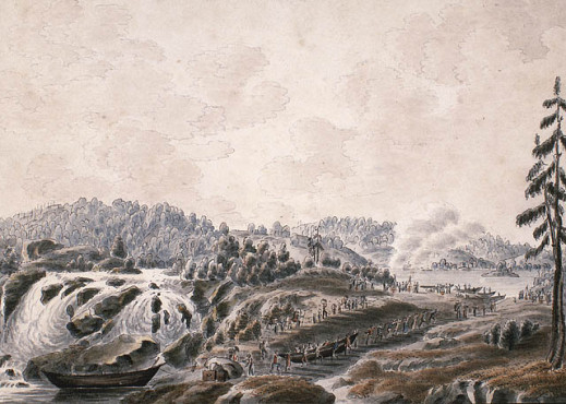
Extremely wearisome journeys at the portages [1821] (e008299434).

This popular blog post describes the work of Peter Rindisbacher. Rindisbacher was 15 years old when he immigrated to Selkirk’s Red River settlement in 1821. Already an accomplished artist when he arrived in North America, he produced a series of watercolours documenting the voyage to Rupert’s Land and life in the settlement. His watercolours from the Red River area are among the earliest images of western Canada. Rindisbacher is considered the first pioneer artist of the Canadian and the American West.

Want to learn more about Peter Rindisbacher? Try the podcast, Peter Rindisbacher: Beauty by commission.

The Persons Case

Five women in gowns wearing corsages and one man in a tuxedo standing in front of a plaque.

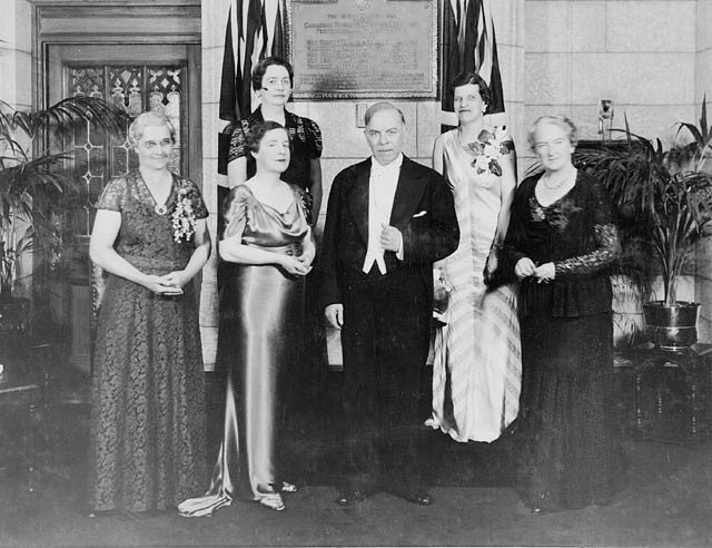
Unveiling of a plaque commemorating the five Alberta women whose efforts resulted in the Persons Case, which established the rights of women to hold public office in Canada (c054523).

This blog post illuminates the history of women’s fight for political equality in Canada. The Persons Case, a constitutional ruling that established the right of women to be appointed to the Senate, began in 1916 when Emily F. Murphy was appointed as the first female police magistrate in the British Empire. Undermining her authority, lawyers challenged her position as illegal on the grounds that a woman was not considered to be a person under the British North America Act, and therefore she was unable to act as magistrate. Murphy enlisted the help of Henrietta Muir Edwards, Nellie Mooney McClung, Louise Crummy McKinney, and Irene Marryat Parlby—now known as the “Famous Five”—who were engaged politically and championed equal rights for women.

Want to learn more about women’s rights throughout Canada’s history? Try the post, A greater sisterhood: the women’s rights struggle in Canada.

The Canadian Expeditionary Force Digitization Project is Complete!

A page from the service file of “Scotty” Davidson describing how he was killed in action in the field by a shell falling in the trench, and how he is buried in a grave with three other 2nd Battalion men.

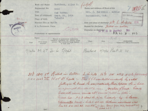
A page from Allan “Scotty” Davidson’s digitized service file describes how he was killed in action (CEF 280738).

The last post on our list is an impressive one! The blog announcing the completion of LAC’s 5-year project to digitize all 622,290 files of soldiers who enlisted in the First World War was well-received by many researchers.

Want to learn more about how the Canadian Expeditionary Force digitization project started? Try the post, Current status of the digitization of the Canadian Expeditionary Force Personnel service files.

We hope you enjoyed our trip down memory lane. You may also be interested in blogs about Canada’s zombie army, the Polysar plant, LAC’s music collection, historical French measurement standards, or the iconic posters from the Empire Marketing Board.

Plaisance: A French fishing colony in Newfoundland

By Valerie Casbourn

Library and Archives Canada (LAC) holds records related to the French colonial period in early Canada, and some of these records are available online. Included are records about the French cod fishery in the Atlantic region and the French colony of Plaisance in Newfoundland (1662–1713).

During the 17th century, the cod fishery in Newfoundland became increasingly important to the European fishing industry. France was one of several European countries competing for a share of this fishery, and in 1662, the French established a garrison town at Plaisance, on the western side of Newfoundland’s Avalon Peninsula. The French wanted to secure their merchant fishing fleet’s access to the fishery and their share of the European market for cod.

The site of Plaisance was chosen for its proximity to rich fishing grounds, its sheltered and relatively ice-free harbour, and its strategic location. Eventually, the colony of Plaisance grew to have a small permanent population, with military fortifications, and served as a base for the French Atlantic cod fishery.

A hand-drawn and coloured illustration that shows the shore with people on a wooden stage working on curing and drying cod in Newfoundland.

A view of a stage and also of the manner of fishing for, curing and drying cod at New Found Land […] (c003686) A digitized copy of the map L’Amerique, divisee selon l’etendue de ses Principales Parties, et dont les Points Principaux sont placez sur les Observations de Messieurs de L’Academie Royale des Sciences. Dressee Par N. de Fer, Geographe de Monseigneur le Dauphin can be seen at the Osher Map Library website.

The French and English established colonies along the southeastern coast of Newfoundland, which encroached on the Indigenous territory of the Beothuk and the Mi’kmaq. The French had little recorded interaction with the Beothuk, who withdrew from the coast and its resources to avoid contact with the European fishermen and colonists. Before the arrival of the colonies the Mi’kmaq navigated the waters between Cape Breton and Newfoundland by canoe. They established friendly relations with the French, becoming important trading partners and military allies.

The colony of Plaisance encountered many difficulties, particularly during its first few decades. Its population was small and poorly supplied, and its early governors were ineffective. However, in the 1690s, the colony became stronger, and the French administration highly valued the Atlantic fishery.

The economy of Plaisance was largely based on the cod fishery. The colony’s small permanent population with its “habitants-pêcheurs” was bolstered each year with the arrival of a large seasonal workforce on the merchant fleet from French ports. All worked intensely to catch and preserve cod during the summer months. The residents of Plaisance relied on the merchant fleet to bring extra labourers, food and manufactured goods, and to ship their dried catch back to Europe to be sold.

During this period, there was ongoing conflict between the French and the English, as well as between the Mi’kmaq and the English. In the 1690s and early 1700s, both the French and the Mi’kmaq conducted raids, sometimes jointly, on English settlements on the Avalon Peninsula. The War of the Spanish Succession culminated in the Treaty of Utrecht, signed in 1713, in which France ceded its claim to Newfoundland to England. The English took over the settlement of Plaisance, changing its name to Placentia. Most of the French colonists moved south to the colony of Ile Royale (now Cape Breton). There they established themselves in the new French settlement of Louisbourg and continued their work in the French cod fishery. The French also retained the right to fish off the coasts of Newfoundland and to process their catch along stretches of the shoreline, known as the French Shore.

Nautical chart, on vellum in coloured ink, of the coastline of Newfoundland, Acadia and the Gulf of St. Lawrence.

Nautical chart of the coastline of Newfoundland, Acadia and the Gulf of St. Lawrence. Produced after 1713, the chart shows both Plaisance and Louisbourg (e011182107)

Records at Library and Archives Canada

LAC holds records related to the colony of Plaisance, among other topics, in the Fonds des Colonies (MG1). This fonds includes copies and transcriptions of selected records related to the French colonial period in early Canada. The records are in French, and the original documents are held at the Archives nationales d’outre-mer in Aix-en-Provence, France. The Fonds des Colonies consists of records including correspondence, reports, journals, instructions, records of fortifications and commerce, civil registers, and notary documents.

Many records in the Fonds des Colonies have been digitized and are available directly on the LAC website. Use LAC’s Collection Search to search for records about the colony of Plaisance. Try keyword searches, such as “MG1 Plaisance” or “MG1 pêche” (without quotation marks), and use the drop-down menu to search “Archives.” Including “MG1” will limit your search results to records in the Fonds des Colonies; you can search more broadly by not including it. Because the original records are in French, try using French keywords such as “pêche” (fishing), “Terre-Neuve” (Newfoundland), or “morue” (cod).

Related resources


Valerie Casbourn is an archivist based in Halifax with Regional Services at Library and Archives Canada.

Images of Point Pelee National Park and Pelee Island now on Flickr

A black-and-white photograph of Kathleen Hart and Dave Phipps sunbathing on the beach.

Kathleen Hart and Dave Phipps sunbathing on the beach at Point Pelee National Park, Ontario. [MIKAN 4297909]

Point Pelee National Park is located in southwestern Ontario. The park is a peninsula that extends into Lake Erie and consists of marsh and woodland that are home to diverse flora and fauna. In 1918, Point Pelee was the first national park created for conservation at the urging of birdwatchers and hunters.

A black-and-white “Plan of the Naval Reserve at Point Pelee in the Township of Mersea..."

“Plan of the Naval Reserve at Point Pelee in the Township of Mersea…,” Ontario. [MIKAN 3670979]

A black-and-white map of Point Pelee Island, Ontario.

Point Pelee Island, Ontario. [MIKAN 3670898]

Pelee Island is the largest island in Lake Erie and lies southwest of Point Pelee National Park, but is not part of the park. The island is abundant with wildlife and is an important flyway for migrating birds between Ohio and Ontario. The island also has a long history of wine making.

A black-and-white photograph of a Pelee Island wine vat now used as a water reservoir.

Pelee Island wine vat now used as a water reservoir, Pelee Island, Ontario. [MIKAN 3642953]

Visit the Flickr album now!

Images of Bird’s-Eye Views now on Flickr

 The expression “a bird’s-eye view” indicates the perspective of an area or object in relation to other things, such as a map, blueprint, or cityscape. Often depicted in drawings or photographs, a bird’s-eye view offers a reference point from high overhead.
A black-and-white photograph of Niagara Falls from a bird’s-eye perspective. There are various buildings on either side of the border and roads leading up to and alongside the riverbanks.

Bird’s-eye view of Niagara Falls with the various power plants on the Canadian side, Ontario (MIKAN 3318089)

A black-and-white photograph of Calgary, Alberta, from a bird’s-eye perspective. The Bow River and a bridge are in the foreground with a number of homes and larger buildings in the background.

Bird’s-eye view of Calgary, Alberta (MIKAN 3302621)

Some synonyms for bird’s-eye view include aerial view, aerial viewpoint, overhead view, bird’s-eye shot, and bird’s-flight view. There are slight differences in perspective, but all appear to depict the area from up above.

A black-and-white photograph of Cabri, Saskatchewan, from a bird’s-eye perspective. It shows a main dirt road with neighbouring houses and buildings. Some people, horses and wagons gather throughout the town.

Bird’s-eye view of Cabri, Saskatchewan (MIKAN 3259496)

A black-and-white map of Winnipeg, Manitoba, from a bird’s-eye perspective. The Red River is central, showing steamboats navigating it and settlements and main roads established along its banks.

Bird’s-eye view of Winnipeg, Manitoba (MIKAN 4146329)

Visit the Flickr album now!

Guest curator: Annabelle Schattmann

Banner for the guest curator series. CANADA 150 is in red along the left side of the banner and then the bilingual text: Canada: Who Do We Think We Are? and under that text is Guest curator series.Canada: Who Do We Think We Are? is a new exhibition by Library and Archives Canada (LAC) marking the 150th anniversary of Canadian Confederation. This exhibition is accompanied by a year-long blog series.

Join us every month during 2017 as experts, from LAC, across Canada and even farther afield, provide additional insights on items from the exhibition. Each “guest curator” discusses one item, then adds another to the exhibition—virtually.

Be sure to visit Canada: Who Do We Think We Are? at 395 Wellington Street in Ottawa between June 5, 2017, and March 1, 2018. Admission is free.


The Chewett Globe by W.C. Chewett & Co., ca. 1869

A large globe in a wood and brass stand.

Terrestrial globe by W.C. Chewett & Co. for the Ontario Department of Education, ca. 1869. (AMICUS 41333460)

This globe was one of the first produced in Canada, around the time of Confederation. Designed for use in schools, it was part of a nationalistic push to define and explain the brand new country.


Tell us about yourself

I have travelled extensively for both pleasure and work. I have been to Europe multiple times, and Peru for archaeological digs as a student. I also spent over a year living in Japan as a high school student, and it was an unforgettable experience. The most important lesson I learned was to appreciate and respect things that are different, strange, and sometimes incomprehensible. It taught me to be critical of my biases and the culture I live in, reflexes which promote cohesive living in a multicultural world.

Is there anything else about this item that you feel Canadians should know?

Because of my expertise and love of travel, I have chosen to discuss the Chewett Globe. Maps are a lot of fun! Whenever I travel, I like to look up the country’s world map because they always put their country in the middle of the map. This inevitably causes distortion in the distances between countries and the size of oceans as our planet is spherical. Seeing Canada shrink and stretch has always made me smile and helped me understand how other people see and understand their world, if only a little bit.

Our world is also ever changing, from its physical features, such as rivers and mountains, or abstract constructs, such as names and borders. Therefore, maps must be continuously updated, which allows us to trace history through changes in maps. Maps are critical to my work as an archaeologist. Old city plans might reveal where old buildings once stood or abandoned cemeteries were located but have since been built over and faded from our collective memory. I also must consider how the landscape may have looked like in the past to understand what resources people could access, and what might have inspired them to choose a specific location to camp or imbue meaning onto the landscape through stories and legends.

I think Mr. William Cameron Chewett, the person whose company created this globe, would have appreciated these thoughts. Although his profession was printing, his family were involved with mapping Upper Canada. His grandfather, William Chewett, worked as surveyor-general and surveyed most of what is now Ontario, while his father, James Chewett also worked as a surveyor before building many known Toronto buildings. W.C. Chewett and Co. was considered one of Canada’s foremost printing and publishing firms. The firm produced award-winning lithographs between 1862 and 1867, with yearly first place awards, and had a large publication output ranging from periodicals, directories, and the Canadian Almanac, to law and medicine books. In addition, the retail store was a popular social gathering spot. The globe was created in the company’s last year (1869) prior to it being bought and renamed the Copp, Clark and Company.

A map of Canada West, what is now southern Ontario, with coloured outlines to indicate counties. The legend contains a list of railway stations with their respective distances [to Toronto?].

Map of Canada West, engraved and published in the Canadian Almanack for 1865 by W.C. Chewett & Co., Toronto. (MIKAN 3724052)

For Canada’s150th anniversary, I think it is worth reflecting on the changes that have come to pass in the last 150 years, which the Chewett Globe can literally show us. In my lifetime, I observed the creation of the territory of Nunavut and the renaming of various streets in my neighbourhood. What changes have you seen in your life and how did they affect you and your community?

Tell us about another related item that you would like to add to the exhibition

When most people think of maps, they think of geography and political borders, but maps can also be used to illustrate and describe almost anything, including census information, spoken languages, and group affiliations amongst others. To continue the topic, I have selected an 1857 map of North America that shows the regions where various First Nations groups resided at the time. Ideally, if I were to add this map to the exhibition, I would also want to include a modern map of where First Nation groups reside to show the public the momentous changes lived by our fellow citizens to allow them to see these changes as clearly as those they can pick out by comparing the globe to any modern map of Canada.

My other reasoning is a little more selfish. As an anthropologist, I understand and have learned through experience that the best way to appreciate and respect another culture is to learn about it, about the people, and where possible, live in it. Growing up, I had very little exposure to First Nations, their culture and history. Because of this, I never developed much of an appreciation for their culture or interest in learning about them. As an anthropologist and Canadian, I was ashamed of these feelings and sad when fellow Canadians express similar views. For the last few years, I have actively sought to educate myself. By including this piece, I hope to inspire others to appreciate, respect, and learn more about their fellow Canadians. The topic is particularly meaningful on Canada’s milestone year as this is the year we should celebrate coming together and developing stronger bonds, one nation to another.

A large colour map of North America denoting territories of various Aboriginal bands with legends in the corners.

Map of North America denoting the boundaries and location of various Aboriginal groups. (MIKAN 183842)

Biography

Colour headshot of a woman with glasses and long hair.Annabelle Schattmann is a physical anthropologist. She holds a Master of Arts in Anthropology from McMaster University (2015) and a Bachelor of Arts in Anthropology from Trent University (2012). She has participated in multiple research projects including a dig in Peru, cemetery excavation in Poland, and research on vitamin C and D deficiencies from various time periods in Canada and Europe.

Related Resources

McLeod, Donald W. “Chewett, William Cameron.” Dictionary of Canadian Biography.

The Parliament Hill Precinct

The Parliament Buildings in Ottawa are some of the most recognizable structures in Canada. Although the Peace Tower may be the most iconic part of the exterior of the buildings, it’s the newest addition to the precinct. Originally built between 1859 and 1866 in the Victorian High Gothic Revival style, Centre Block officially opened on June 6, 1866 as Parliament for the Provinces of Canada. The location was chosen by Queen Victoria in 1857 and was the biggest construction project of its time in North America, running way over budget, in part due to the cost of blasting out the bedrock to build the foundation. On July 1, 1867, Centre Block was chosen to be the official Parliament for the Dominion of Canada. Its location was considered ideal for many reasons, namely its distance from the American border, as well as its visibility to those who lived in the area.

A black-and-white photograph of the original Centre Block on Parliament Hill.

Parliament Buildings, Centre Block, by Captain Jacobs, c. 1886 (MIKAN 3319558)

Centre Block stood on Parliament Hill for 50 years until the evening of February 3, 1916 when a fire broke out in the House of Commons’ reading room. The flames spread quickly and seven lives were lost that night. While many of the stone walls remained standing, the only part of the building to truly survive was the library, which was built in 1876 with iron doors (which were closed by a clerk before leaving that evening). Although rumours claimed arson was the cause, the fire was a result of a discarded cigar.

A black-and-white photograph showing a very elaborate round building with pinnacles and flying buttresses in a wintry setting next to a building partly encased in ice. Firemen are putting out a fire.

View of the Library of Parliament and Centre Block on the day after the Centre Block fire, taken by William Topley in 1916 (MIKAN 3194673)

Despite Canada being heavily involved in the First World War at the time, it was clear that the buildings had to be rebuilt. With the country expanding, it was decided that the Parliament Buildings would follow suit. The plan was to keep the same Gothic Revival style as the original buildings without creating carbon copies of them. Construction started later that year and was completed in 1922. The Peace Tower, named in commemoration of Canada’s commitment to peace, was completed in 1927.

A black-and-white photograph showing the first three stories of a building with the rotunda of the Library of Parliament in the background. Cranes and construction materials surround the area.

Rebuilding of the Centre Block, Parliament Buildings, c. 1917-1918. Photo taken by Samuel J. Jarvis (MIKAN 3319865)

A black-and-white photograph showing the main Parliament building from the front with crowds of people filling Parliament Hill.

Jubilee celebrations on Parliament Hill in 1927 (MIKAN 3549627)

Today, Centre Block is bordered by the East and West Blocks and by a large public open space that serves many purposes—it’s a celebration area on Canada Day, a place for demonstrations and protests, a spot for noontime yoga in the summer, etc. Tours of Centre Block are given throughout the year and it’s become one of Ottawa’s most popular attractions.

Other resources

Underwater Canada: A Researcher’s Brief Guide to Shipwrecks

Shipwrecks, both as historical events and artifacts, have sparked the imagination and an interest in the maritime heritage of Canada. The discovery of the War of 1812 wrecks Hamilton and Scourge, found in Lake Ontario in the 1970s, and the discovery of the Titanic in the 1980s, served to heighten public awareness of underwater archaeology and history.

Whether you are a wreck hunter on the trail of a lost vessel, or a new shipwreck enthusiast eager to explore images and documents that preserve the epic tales of Canadian waters, Library and Archives Canada (LAC) has something for you.

Starting your research

First, gather as much information as possible about the shipwreck(s) you are researching. Specifically, you will ideally want to obtain the following information (in order of importance):

  • Name of Vessel
  • Location of accident
  • Date of accident
  • Ship’s port of registry
  • Ship’s official number
  • Year of vessel’s construction

The Ship Registration Index is a helpful resource. The database includes basic information about more than 78,000 ships registered in ports of Canada between 1787 and 1966.

Can’t locate all of the information listed? There’s no cause for concern! Not all of the information is necessary, but it is essential that you know the name of the vessel. All Government records relating to shipwrecks are organized according to the ship’s name.

What is Available?

Using Archives Search, you can locate the following types of material:

Photographs

Maps

  • In Archives Search, under “Type of material”, select “Maps and cartographic material” to narrow your results.
    Government Records

All records listed are found in the documents of the Marine Branch (Record Group 42) and/or Transport Canada (Record Group 24).
Official Wreck Registers, 1870‒1975

  • Wreck Reports, 1907‒1974
  • Register of Investigations into Wrecks, 1911‒1960
  • Marine Casualty Investigation Records, 1887‒1980

Important: Government records contain information about shipwrecks that occurred in Canadian waters, and include all accidents involving foreign vessels in Canadian waters.

Please note: this is not an exhaustive list of resources, but rather a compilation of some of the major sources of documentation available on shipwrecks held at LAC.

Helpful Hints

You can find a number of digitized photographs, maps and documents on the Shipwreck Investigations virtual exhibition. More specifically, check out the collection of digitized Official Wreck Registers in the Shipwreck Investigations Database. Simply check if the name of the vessel you are researching is listed.

Another excellent source of information on shipwrecks is local public libraries. There are many maritime histories and bibliographies that offer reference points to begin your shipwreck research.

Sir John Coape Sherbrooke: Military Hero, Governor General, Clairvoyant?

Last year, Library and Archives Canada (LAC) acquired an important collection of documents relating to the Canadian career of Sir John Coape Sherbrooke (1764-1830). His pivotal role in the defence of the British colonies that would become the Atlantic Provinces during the War of 1812 led to his appointment as Governor General of British North America in 1816. However, his arrival in Nova Scotia in October of 1811 was not his first time in Canada.

Detail from an engraving. Portrait of Sir John Coape Sherbrooke

Portrait of Sir John Coape Sherbrooke (Mikan 4310479)

Continue reading

Samuel de Champlain’s General Maps of New France

In the fall of 1612, Samuel de Champlain had an engraving of his first detailed map of New France made in Paris. The map contained new geographic information, based on his own explorations from 1603 onward. The site of Montreal is clearly identified. Using information obtained from Aboriginal peoples, he was able to include previously uncharted areas, such as Lake Ontario and Niagara Falls. He also made use of other maps to depict certain regions, including Newfoundland. Although the engraving was made in 1612, the map was not published until the following year as an appendix to Voyages, Champlain’s 1613 account of his journeys.

Carte geographique de la Nouvelle Franse faictte par le sieur de Champlain Saint Tongois cappitaine ordinaire pour le roy en la marine. Faict len 1612.

Carte geographique de la Nouvelle Franse faictte par le sieur de Champlain Saint Tongois cappitaine ordinaire pour le roy en la marine. Faict len 1612.(e010764733)

While back in France in the summer of 1613, Champlain had an engraving made of a second version of a general map that he had begun the previous year, which he also published in his 1613 book. In that map, he incorporated his most recent geographic findings, including the Ottawa River, which he was the first to depict. His depiction of Hudson Bay was deliberately inspired by a map of Henry Hudson’s voyages.  

Carte geographique de la Nouvelle Franse en son vray meridiein. Faictte par le Sr Champlain, Cappine. por le Roy en la marine – 1613.

Carte geographique de la Nouvelle Franse en son vray meridiein. Faictte par le Sr Champlain, Cappine. por le Roy en la marine – 1613. (e010764734)

An incomplete general map by Champlain also exists. The engraving was made in 1616, although the map was never published. The only known copy is held by the John Carter Brown Library.

In 1632, Champlain published his last major map of New France, which was included in his final book, Les Voyages de la Nouvelle France occidentale, dicte Canada. He had been living in France for nearly three years, having been driven out of Quebec by the Kirke brothers in 1629. This updated map contains little new information verified by Champlain himself, as his own explorations came to an end in 1616. He based the revised version on the invaluable information conveyed to him by others, chief among them Étienne Brûlé. Nevertheless, this map represents an important milestone in the history of North American cartography and was widely used by other mapmakers. There are two versions of this map. Among the differences between them are the representation of Bras d’Or Lake or a chain of mountains on Cape Breton Island. Both versions of the map are held by Library and Archives Canada. The first can be seen here:

Carte de la Nouvelle France, augmentée depuis la derniere, servant a la navigation faicte en son vray meridien, 1632.

Carte de la Nouvelle France, augmentée depuis la derniere, servant a la navigation faicte en son vray meridien, 1632. (e010771375)

Suggested reading to learn more about this subject: Conrad E. Heidenreich and Edward H. Dahl, “Samuel de Champlain’s Cartography, 1603-32”, in Raymonde Litalien and Denis Vaugeois, eds., Champlain: The Birth of French America. Sillery: Les éditions du Septentrion; and Montreal and Kingston: McGill-Queen’s University Press, 2004, pp. 312-332.

The Mountain Legacy Project: An Archive-Based Scientific Project

Beginning in 1871, the Dominion Lands Branch had been surveying and mapping Canada from East to West. By 1886, the Dominion Lands Survey had extended to the Rocky Mountains, but the rugged terrain made traditional survey methods impractical. Édouard-Gaston Deville, Surveyor General of Canada, devised a new methodology called “phototopography,” (also known as photogrammetry) based on the use of survey photography from hot-air balloons in France and Italy. A special camera was constructed for surveyors, who ascended thousands of peaks in Alberta, British Columbia and the Yukon. They rotated and levelled their cameras on tripods to create 360-degree views of the surrounding terrain. Between 1887 and 1958, more than 100,000 glass plate negatives were used to create the first topographic maps of the Canadian Rockies, of which 60,000 are now part of the Library and Archives Canada (LAC) collection.

Since 2002, LAC has been a major participant in the Mountain Legacy Project, an ongoing partnership led by the University of Victoria, which includes stakeholders in universities, archives, government, and non-governmental organizations.

LAC identifies, describes and digitizes the original negatives. These photographic records are the foundation of this multidisciplinary project, which uses “repeat” photography. It consists of re-photographing the landscape from the precise original locations to provide information about environmental changes that have occurred over the last 120 years.

To search LAC holdings of original photographs, follow these easy steps:

  1. Go to the Basic Archives Search.
  2. Enter the archival reference number R214-350-0-E in the search box.
  3. From the Type of material drop-down menu, select Photographic material and then click on Submit. Your search will generate a list of results.
  4. Select an underlined title to access the full description of a photograph. The descriptive records display images of photographs that have been digitized.

For more information about how to search for photographs at LAC, consult our articles “How to Find Photographs Online” and “How to Search for Images Online.”

If you wish to narrow your search:

  1. Go to the Archives Advanced Search.
  2. Select Photographic material from the drop-down menu labelled Type of material
  3. Use one or a combination of the following options as keywords in the Any Keyword search box:
    1. Name of the surveyor (e.g., Bridgland, McArthur or Wheeler).
    2. Year of the survey (must be used along with another keyword to limit search).
    3. Name of a survey (e.g., Crowsnest Forest Reserve, or Interprovincial Boundary Survey, although these may have taken place over several years, by various surveyors).
    4. Name of a particular landscape feature, such as mountain peak, river, creek, or valley (often the views are identified by the station/peak they were taken from, rather than by the peak or landscape featured in the photograph).
    5. Name of the park (Note: The LAC collection does not contain reproductions of the images from Jasper and Banff National Parks).
  4. Limit your search results by selecting a decade under the label “Date” on the right side of the screen.

For more information about the Project, and to compare the archival images with the repeat photography, visit the Mountain Legacy Project website. To view a sampling of paired photographs, visit our Flickr Set. To view some images of the surveyors, visit our Facebook Album.

Questions or comments? We would love to hear from you!