That sinking sensation: Leda clay in and near Ottawa

By Ellen Bond

In the 1970s, there were two shows I looked forward to every weekend: The Wonderful World of Disney on Sunday (feel-good stories) and The Bugs Bunny/Road Runner Hour (cartoons) on Saturday. It wasn’t the ACME dynamite or the crazy coyote that scared me on Saturday—it was the quicksand! Being stuck in cement-like mud sounded horrendous to me. So imagine my feelings when I learned that most of Ottawa is built over a massive amount of Leda clay, which can liquefy from ground tremors, forming a type of quicksand. Quicksand? Here in Ottawa? Not only in the desert of Wile E. Coyote? Yikes!

A colour map showing the area of land covered by the Champlain Sea

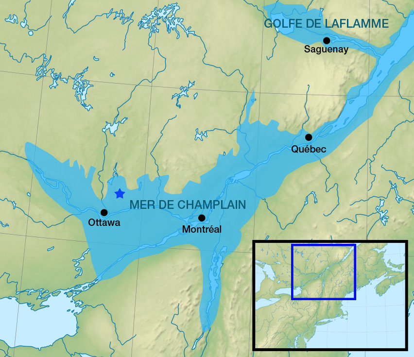
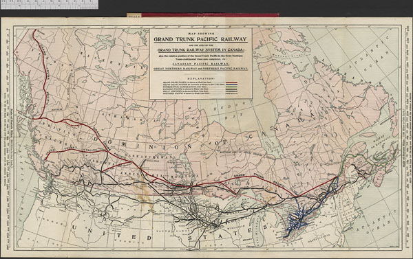
A map showing the former location of the Champlain Sea after the last period of glaciation (Wikipedia) Credit: Orbitale

The Champlain Sea and the formation of Leda clay

After the last ice age, the climate warmed and the snow and ice melted. Massive spillways, which carried melting glacial waters and looked like enormous rivers, moved the water away from the remaining glaciers and sometimes formed lakes. In the area now known as the Ottawa Valley, a vast inland shallow sea formed 15,000 years ago. Geologists named it the Champlain Sea. What is unique about this sea is the Leda clay that was deposited in areas of deeper water.

You may wonder what happened to the Champlain Sea and why these lands are not still underwater. There are two reasons: evaporation and the rebounding of land once freed from the incredible weight of a 1- to 3-kilometre deep glacier. The land previously under the glaciers in North America is still rebounding today, 15,000 years later!

Leda clay (also known as quick clay and Champlain Sea clay) was formed by sediment eroding from the earth and landing at the bottom of the sea. The Champlain Sea was full of both fresh water from the glacial melt and salt water from the ocean. When salt molecules combine with the clay molecules, it makes a stable clay. But if fresh water infiltrates the clay and washes away the salt, the clay becomes very unstable. An unstable clay molecule is prone to liquefying.

Why doesn’t Leda clay liquefy more often?

You may wonder why the Leda clay under Ottawa and the lands around the St. Lawrence River doesn’t liquefy all the time. For the most part, the clay is underneath the surface and away from fresh water, and so is very stable. However, earth tremors, whether natural (earthquakes, erosion) or human created (explosions, blasting, digging), can allow fresh water to seep into the Leda clay, removing the salt molecule. If that clay is on a hill or on the edge of a winding river, this leads to landslides.

Leda clay has been found responsible for over 250 landslides in Canada alone. In the Ottawa area, Leda clay was responsible for the Canadian Museum of Nature building’s tower sinking in 1915 and, more recently, holding up new developments in Ottawa South in 2021. It was also responsible, in part, for the Rideau Street sinkhole that appeared with train construction in downtown Ottawa in 2016.

The landslide disaster at Notre-Dame-de-la-Salette

Notre-Dame-de-la-Salette is in the area formerly covered by the melt waters from the Champlain Sea. The village is northeast of Ottawa, in Quebec, and marked by an orange star in the map of the Champlain Sea above.

Disaster struck in the middle of the night in Notre-Dame-de-la-Salette on April 26, 1908, when a riverbank of the frozen Lièvre River gave way. Fresh water had infiltrated the Leda clay molecules, making them unstable, and the riverbanks collapsed, propelling a wave of mud, ice and ice-filled water across the river and into the town. Thirty-four people lost their lives and at least twelve homes were destroyed.

A river with tree stumps on the left side and homes on the right side.

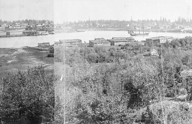
Looking up Lièvre River from Notre-Dame-de-la-Salette, Quebec (a040044-v6)

Water moves in a straight line until it meets resistance. In this historical photo of the area, the water in the river is flowing towards the riverbank (blue arrow), and it was here that the riverbank gave way. Labelled in green you can see the stumps left behind following the clearcutting of trees along the bank. Without the layer of trees to protect the bank, the entire area was prone to eroding quicker than before the cut. Some of the village of Notre-Dame-de-la-Salette can be seen across the river from where the landslide occurred. At this time, there is no island in the middle of the river, and there are houses close to the river on the town side. Comparing this image to ones after the slide, there is a stark difference. Look for changes to this scene in some of the photos that follow, especially house placement.

A river cutting through a hilly landscape with houses along the river.

Southeast view of the Lièvre River Valley and Notre-Dame-de-la-Salette (a044070-v8)

Another old photo from the LAC collection shows the river flowing away from the viewer. Look closely, and you can see where the earth gave way and the island formed in the middle of the river after the landslide.

A river with hills in the background. There is a small island in the river and a bridge farther upstream.

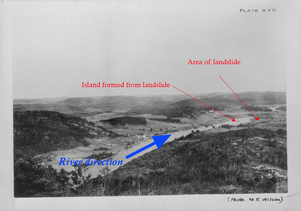
Former town site of Notre-Dame-de-la-Salette, Lièvre River, Quebec. Photo looks upstream. (a020267)

In the photo above, the river is flowing towards the viewer, and you can see the bridge crossing the river, north of town. A red arrow points to where the riverbank gave way during the landslide. A new island formed in the middle of the river from the sediment and material moved in the slide. The other change is that there is now a clearing where the town site had been—people rebuilt the town further away from the river.

A white cross on the edge of a ridge. The land below the ridge is considerably lower than the ridge.

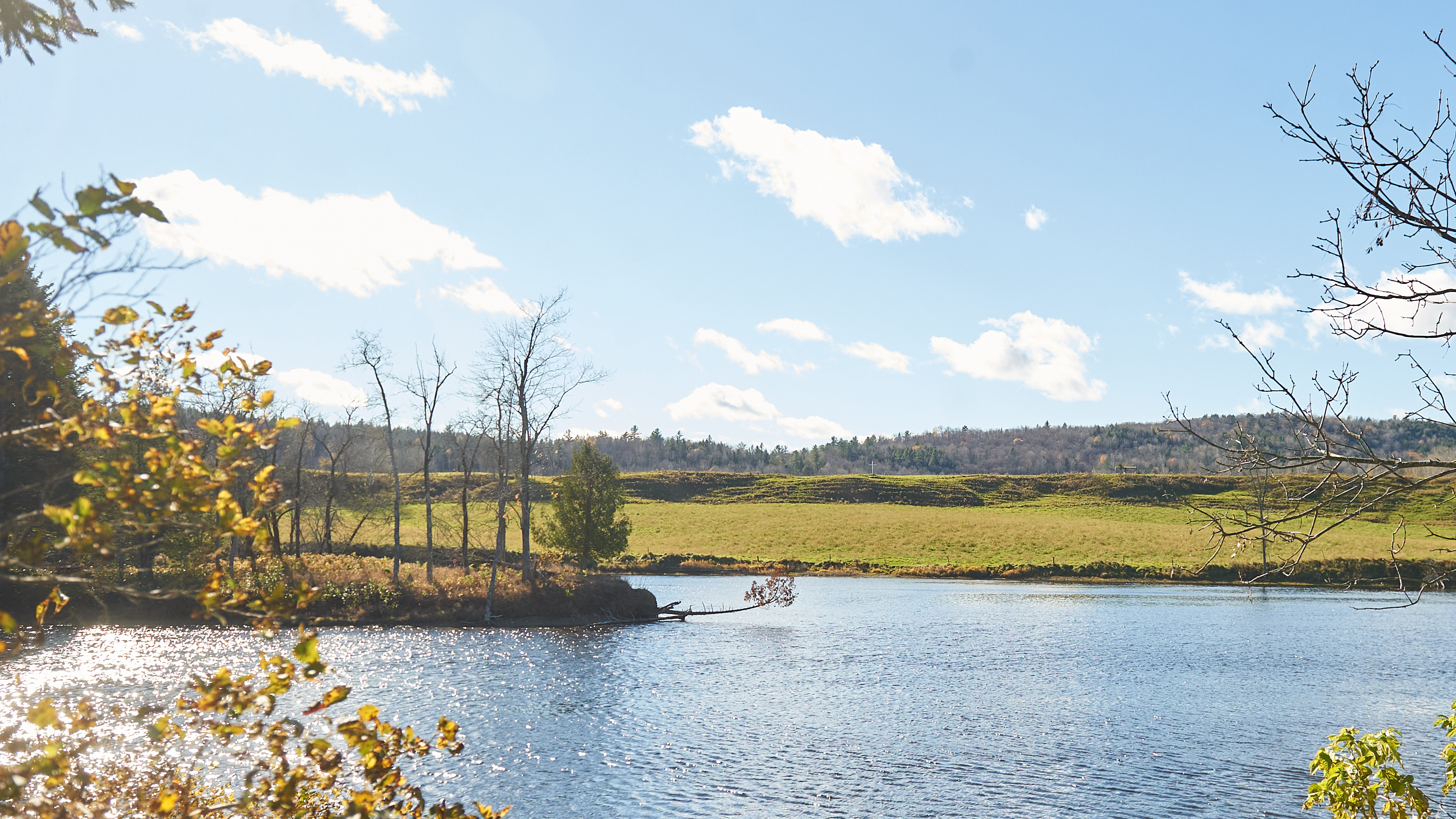
A white cross stands on the edge of where the land gave way in 1908, leaving a scar on the land still visible today. Photo credit: Ellen Bond

The colour photo above was taken recently, and you can see the area affected (where the land gave way along the ridge), the island formed from the slide and a memorial white cross on the hill.

A river bend with water flowing towards the shoreline of the bend.

A recent photograph of the area affected by the landslide. Photo credit: Ellen Bond

The above photo looks downstream at the slide location. The slide area is shown in yellow, and you can see the ridge above. On the left, you can see the edge of the island that formed after the slide.

A large rock with a metal plaque describing the event and the names of the victims. The rock is across from the slide location. There is a bench nearby overlooking the memorial and the landslide site.

A memorial across the river from the slide location. Photo credit: Ellen Bond

Inscription on plaque reads: Memorial On April 26th 1908 around 3:30 am, the village was brutally awakened by a loud grumbling noise. A 1200 foot long by 500 feet deep piece of land on the west side of the river suddenly slipped in the river, sweeping in a mass of water, ice and clay, houses, buildings and 34 victims. Ten (10) of the thirty four (34) victims were never found.

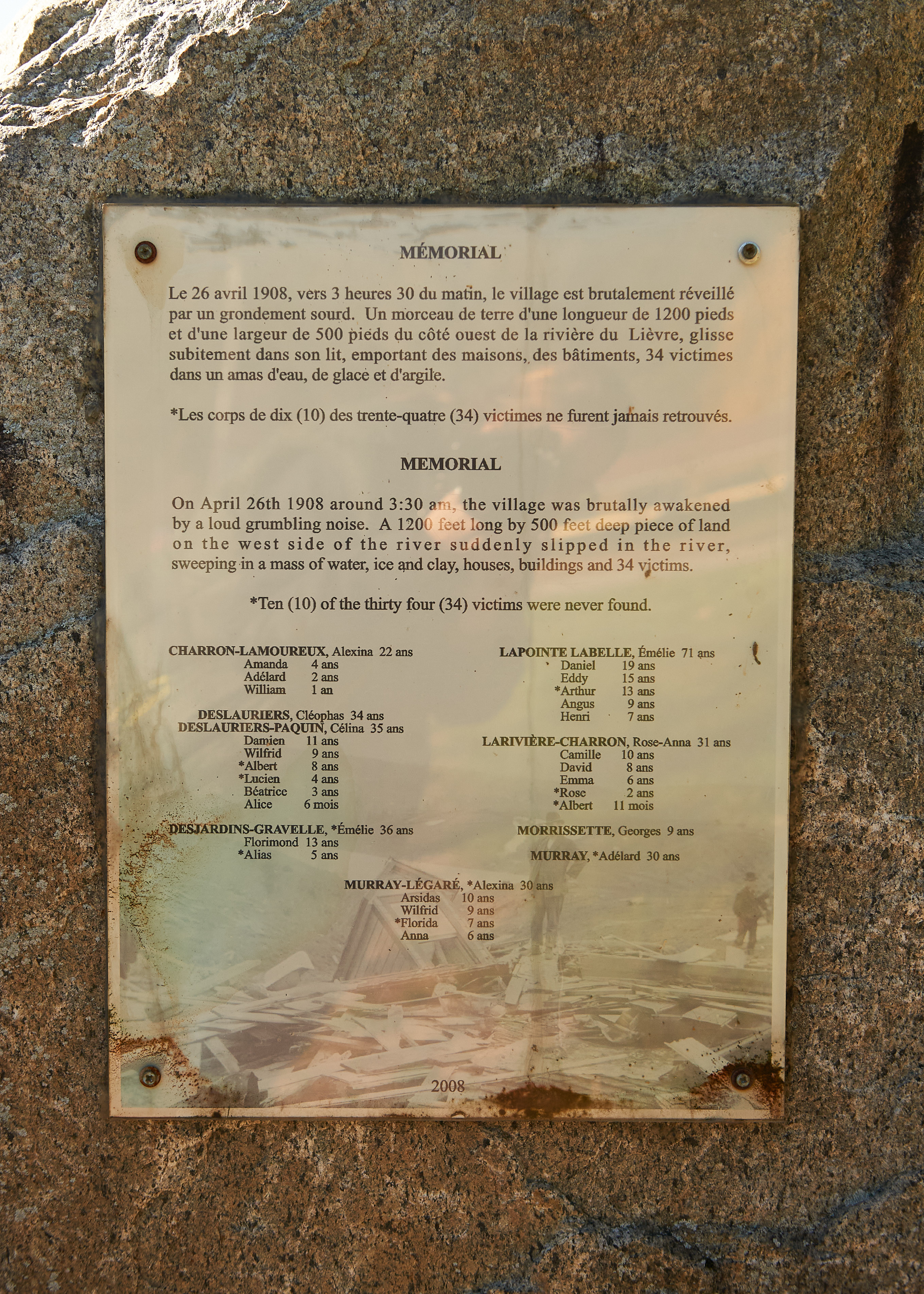
A memorial plaque located near the landslide area. It describes the event and lists the names of the victims. Photo credit: Ellen Bond

Although this landslide occurred over 110 years ago, the effects can be still seen and felt today. In the middle of the night, due to no fault of their own, 34 people lost their lives tragically and unexpectedly. Their names, in each family group, were

  • Alexina, Amanda, Adélard and William Charron-Lamoureux,
  • Cléophas Deslauriers, Célina, Damien, Wilfrid, Albert, Lucien, Béatrice and Alice Deslauriers-Paquin
  • Émélie, Florimond and Alias Desjardins-Gravelle
  • Émélie, Daniel, Eddy, Arthur, Angus and Henri Lapointe Labelle,
  • Rose-Anna, Camille, David, Emma, Rose and Albert Larivière-Charron,
  • Alexina, Arsidas, Wilfrid, Florida and Anna Murray-Légaré
  • Georges Morrissette
  • Adélard Murray

The power of the earth is incredibly strong, and those that inhabit the planet are sometimes the unfortunate recipients of its fury. It happens in regions affected by hurricanes. It happens where two of the Earth’s plates meet and are moving in different directions. It happens where Leda clay has formed. As humans, we cannot control this power. In Notre-Dame-de-la-Salette, the people have adapted to the Leda clay by moving their houses away from the river. Unfortunately, lives were lost learning this lesson. RIP to all of the victims and their families.

A recent photo of the slide area.

Looking across the river to the slide location. The ridge is visible as is the island. Photo credit: Ellen Bond

Additional Resources


Ellen Bond is a project assistant with  the Online Content team at Library and Archives Canada.


Norman Kwong: “I always want to be the winner”

By Dalton Campbell

In 1948, Norman Kwong stepped onto the field with the Calgary Stampeders of the Canadian Football League (CFL) for the first time. The 18-year-old rookie, and eventual Hall of Famer, was the league’s first Chinese-Canadian player.

A colour studio photograph of a football player in uniform, holding his helmet in the crook of his left arm.

Norman Kwong (1929–2016), photo from August 1957 (e002505702)

Norman (born Lim Kwong Yew) was born in Calgary in 1929, the fifth of six children. His parents, Charles Lim and Lily Lee, operated a grocery store. They had immigrated to Canada from Guangdong, China, several years before Norman was born. His obituary in the Edmonton Journal stated that in the 1920s, there were fewer than 5,000 Chinese Canadians in Alberta. The vast majority were men, in large part because the racist and discriminatory “head tax” kept most men from bringing their wives and children to Canada. Norman’s mother was one of only five married Chinese women in Calgary. In 1923, the government passed the Chinese Immigration Act (commonly known as the “Chinese Exclusion Act”), effectively ending immigration from China. In 1947, the year before Norman began his professional football career, the Act was lifted, and Chinese Canadians gained the right to vote.

A black-and white-photograph of downtown Calgary, looking down at an intersection, with streetcars, cars and people visible on the streets and sidewalks.

8th Avenue, Calgary, Alberta, 1937 (e010862070)

In 1950, Norman was traded from Calgary to Edmonton, where he spent the rest of his career. He led the CFL in rushing three times (1951, 1955 and 1956), rushed for over 1,000 yards in four consecutive seasons, and set numerous league and team records. He was a four-time CFL West All-Star (1951, 1953, 1955 and 1956), was twice named the CFL’s Most Outstanding Canadian (1955 and 1956), and received the Lionel Conacher Award as the outstanding Canadian male athlete (1955). In 13 seasons, he played in seven Grey Cup games, winning the championship four times (1948, 1954, 1955 and 1956). He was named to the CFL Hall of Fame in 1969, to Canada’s Sports Hall of Fame in 1975, and as one of the top 50 players in CFL history (by TSN) in 2006.

His Edmonton Journal obituary quotes him as saying, “Sports is life, only it’s distilled into a shorter time. It’s clear-cut. Everything’s out in the open. There’s no way to hide. There’s always a winner and a loser. And I guess that appeals to my competitive nature. Of course, I always want to be the winner.”

Norman retired at the age of 30. He married Mary Lee and entered post-football life, working primarily in commercial real estate. In the 1980s, he returned to sports as an executive with the Calgary Stampeders and was part of the original ownership group of the Calgary Flames of the National Hockey League. When the Flames won the Stanley Cup in 1989, he became one of only five people to have won both the Grey Cup and the Stanley Cup as a player, manager or executive.

A colour image of a coat of arms. The shield in the centre has three footballs lined up diagonally from the upper left to lower right. There are two dragons, one standing on each side of the shield. The motto reads, “Strive to Excel.”

Coat of Arms of Norman Lim Kwong, courtesy of the Canadian Heraldic Authority (Office of the Secretary to the Governor General). The green and gold are the Edmonton team colours, and the horizontal stripes represent the 10-yard lines from a football field. The horse represents his first team, Calgary. The rose represents his wife, Mary, an avid gardener. The dragons represent his Chinese heritage, and the dragons’ hindquarters are representative of the Albertosaurus dinosaur.

Norman Kwong was the National Chair of the Canadian Consultative Council on Multiculturalism (1979–80) and Honorary Chair of the Easter Seals Campaign in Calgary (1982–84). He was named to the Order of Canada (1988) and later served as the Lieutenant Governor of Alberta (2005–10). The Calgary Flames named a bursary for medical students in his honour. He died in Calgary in 2016.

For further research


Dalton Campbell is an archivist in the Science, Environment and Economy Section of the Private Archives Division.

Breaking ground: 150 years of federal infrastructure in British Columbia – Vancouver Island Region: Dominion Astrophysical Laboratory

By Caitlin Webster

British Columbia joined Canada 150 years ago, and in the years that followed, federal infrastructure expanded throughout the province. This infrastructure is well documented throughout Library and Archives Canada’s collections. This eight part blog series highlights some of those buildings, services and programs, as well as their impact on B.C.’s many distinct regions.

While astronomical research predates Confederation, federal investments in the field began in earnest in the early 20th century. After the construction of an observatory in Ottawa in 1905, astronomer John Stanley Plaskett began advocating for a state-of-the-art reflecting telescope. This led to the construction of the Dominion Astrophysical Observatory in Saanich near Victoria, British Columbia. The observatory in B.C. was once the world’s largest telescope facility.

The Dominion Astrophysical Observatory is located in the traditional territories of the Xwsepsum (Esquimalt), Songhees, Tsartlip, Pauquachin, Tsawout, Tseycum and Malahat Nations. Their ancestors were signatories of the Douglas treaties of the 1850s, also known as the Fort Victoria treaties. Differences between the treaty text and the oral histories of the First Nations signatories have led to continuing debate as to whether the treaties were land sales or peace agreements.

Land clearing and construction at the site began in 1914 and continued despite the challenges posed by the First World War.

Black-and-white photograph of a group of men posing with a team of horses attached to a wagon carrying part of a telescope.

Hauling 9.5-ton polar axis to the Dominion Astrophysical Observatory, circa 1916–1917 (a149324-v8)

Work on the observatory sparked interest internationally as well as locally. The site became a tourist destination as residents visited to observe the progress and attend the official opening in 1918.

Black-and-white photograph of a large group of people inside the Dominion Astrophysical Observatory for its opening ceremony. The group is gathered in front of the telescope and on the viewing platform.

Opening ceremony of the Dominion Astrophysical Observatory; view of the telescope (a149323-v8)

With the world’s largest operational telescope at their disposal, Plaskett and his fellow astronomers wasted no time in beginning an ambitious observation program. Specializing in binary stars and later focusing their sights on the Milky Way, the team made extensive contributions in the study of astronomy. Successive teams have continued this vital work, and today the Dominion Astrophysical Observatory is one of two observatories managed by the Herzberg Astronomy and Astrophysics Research Centre.

Black-and-white photograph of the exterior of the Dominion Astrophysical Observatory.

Dominion Astrophysical Observatory (a032169-v6)

The observatory engaged with the public and continues to do so. In the 1920s and 1930s, observatory staff contributed to ongoing local newspaper columns and radio broadcasts on astronomical topics of the day. Today, the charitable organization Friends of the Dominion Astrophysical Observatory promotes public outreach activities at the observatory and the Centre of the Universe visitors centre.


Caitlin Webster is a senior archivist in the Reference Services Division at the Vancouver office of Library and Archives Canada.

Breaking ground: 150 years of federal infrastructure in British Columbia – Cariboo Region: Railway Mail Service, Prince George to Prince Rupert

By Caitlin Webster

British Columbia joined Canada 150 years ago, and in the years that followed, federal infrastructure expanded throughout the province. This infrastructure is well documented throughout Library and Archives Canada’s collections. This eight part blog series highlights some of those buildings, services and programs, as well as their impact on B.C.’s many distinct regions.

After British Columbia joined Confederation in 1871, the extension of rail service to the province allowed the freer movement of people and goods within B.C. and to other parts of Canada. This included the transport of mail for individuals, organizations and businesses. Trains have carried mail since their invention, but in 1897, the federal government officially formed the Railway Mail Service within the Post Office Department.

Departmental order from Deputy Postmaster General William White, dated February 22, 1897, announcing the establishment of the Railway Mail Service Branch. The announcement includes the initial locations and other details regarding the service.

Department Order, No. 38 [Establishment of the Railway Mail Service Branch] (e002151860)

This service used a system of travelling post offices aboard trains, staffed by crews of specialized railway mail clerks. These clerks performed the regular work of receiving, sorting, cancelling and distributing mail, all done while on board trains travelling from town to town. Clerks needed to be speedy, accurate, strong and trustworthy as they prepared often-valuable items for the mail service. Especially tricky was the pickup of mailbags on the fly. The clerk would swing out a catch arm on the side of the rail car to pick up the waiting bag, while simultaneously kicking out a delivery mailbag for that location. The manoeuvre was particularly challenging if the train was running late and going by a station at full speed.

Railway mail cars had various configurations, but all were fitted with dumping tables, sorting cases and other furniture for preparing mail, as well as stoves, toilets and sinks. Although this made for cramped quarters, such equipment was an absolute necessity for crews who often lived on board the cars for long runs.

Black-and-white photograph of a young man beside tables and mailbags in a railway mail car.

Portrait of railway mail clerk A.L. Robinson on the Grand Trunk line’s first Prince George–Prince Rupert run, 1914 (s002386)

In B.C.’s Cariboo region, railways and the accompanying railway mail service arrived somewhat later than in other parts of the province. In 1914, the Grand Trunk Pacific Railway completed a line from Prince George to Prince Rupert as part of its larger network. The company located the terminus of the line on the traditional lands of the Ts’msyen at Prince Rupert, and it purchased 553 hectares of Lheidi T’enneh land to form the new town site of Prince George. However, by 1915, the company was in financial trouble, and the federal government nationalized the railway and integrated it into Canadian National Railways in 1920.

Colour map of Canada and the northern portion of the United States, showing various railway lines across the continent.

Map showing the Grand Trunk Pacific Railway and the lines of the Grand Trunk Railway system in Canada; also the relative position of the Grand Trunk Pacific to the three northern transcontinental lines now completed: Canadian Pacific Railway, Great Northern Railway and Northern Pacific Railway, 1903 (e01751895-v6)

The Railway Mail Service reached its peak in 1950, when it employed 1,385 railway clerks on lines all across the country. However, the service was in decline by the mid-1960s, and while some mail was still carried by rail up to the 1980s, the Railway Mail Service officially ended in 1971.

To learn more about the Railway Mail Service, railways in B.C., and the purchase of the Lheidi T’enneh land for the Prince George town site, check out the following resources:


Caitlin Webster is a senior archivist in the Reference Services Division at the Vancouver office of Library and Archives Canada

A page in Canada’s history: Carnegie libraries

By Sara Chatfield

A black-and-white photograph of a two-storey stone building with a columned portico and ivy growing up its sides.

The Ottawa Public Library opened in 1905, funded by a Carnegie grant. (a044774-v8)

Libraries have always been special places for me. When I was young, my grandmother worked as a reference librarian at my local library, making my visits to the library extra memorable. I have always appreciated the scope of what you could find within the walls of a library: I loved the books, the magazines and chatting with the librarians about new arrivals. But the thing I loved most (and still love most today) about libraries are the buildings that house library collections, especially historic Carnegie library buildings. Carnegie libraries are distinctive buildings built in the late 1800s and early 1900s by Andrew Carnegie to promote free library access in North America and the world.

A colour photo of a one-storey building with brown-brick exterior walls and a green roof. A small set of stairs and a railing lead up to the entrance.

The Renfrew Public library, built in 1919/1920 and funded by a Carnegie grant. Photo credit: Sara Chatfield

To me, Carnegie library buildings have a majestic yet welcoming appearance. The early buildings (1901–1905) were not designed according to standardized plans. The architects, who hailed from Canada and the United States, were free to use their imaginations. Later buildings have similar design elements, such as arched windows, cupolas, porticos and symmetrical columns.

A black-and-white photo of a two-storey building with a columned portico. A man is walking in front of the building. Power lines can be seen to the right and behind the building.

The Galt Public Library, built in 1903, through a Carnegie grant given in 1902 (a031832)

I am not alone in my love of Carnegie library buildings. A former Ontario Minister of Citizenship and Culture once wrote that “Carnegie libraries represent a significant part of the cultural history and architectural heritage of Ontario.”

Carnegie libraries would not have existed without Andrew Carnegie and his lifelong love of libraries and learning. Andrew Carnegie (1835–1919) was born in Scotland and immigrated to the United States with his family in 1848. He amassed a fortune with his Carnegie Steel Company, which he sold in 1901. He placed the money from the sale in trust for philanthropy, which became his main occupation. In total, the philanthropist gave grants to build 2,509 free public libraries to English-speaking communities worldwide. Andrew Carnegie believed the best way to provide free education and foster growing communities was to establish public libraries.

A black-and-white photograph of two ornate buildings, one with a columned portico and a cupola. People walking, a street car, and power lines are in the foreground.

The Vancouver Public Library (right) opened in 1903 with funding from a Carnegie grant. Since 1980, this building has served as the Carnegie Community Centre, which houses a library branch on the main floor. (a009531)

Carnegie provided the grant for each library building, but did not contribute funds towards the purchase of books or staff salaries. To secure a Carnegie grant for a library, cities and towns had to fulfill the “Carnegie Formula.” Among other criteria, this formula stipulated that cities provide the site, guarantee an annual budget and ensure free public access. Many applications for grants were refused because a town or city already had adequate library services or would not be able to guarantee the yearly funds needed for the upkeep of the facility. Some communities did not apply for or accept money from the Carnegie foundation, as they viewed Andrew Carnegie as a robber baron and disapproved of his business methods.

Of the 2,509 Carnegie libraries built in the early 1900s, 125 were constructed in Canada. Of those 125 libraries, 111 were built in Ontario. The majority of the libraries were built in the United States and Great Britain/Ireland. Carnegie libraries were also built in South Africa, Australia, Serbia, New Zealand, Fiji, Mauritius, Barbados and Guyana, among other places.

A colour photo of a brown-brick building with several beige accent columns as well as pediments and curved windows. There are red flowers to the left in the foreground.

The former Perth Carnegie Library, now known as the Macmillan Building. The two-storey library was designed in the Beaux-Arts style by renowned architect Frank Darling. The building was severely damaged by fire in 1980 and restored in 1982. Photo credit: Emily Tregunno

I have always found it interesting that the Carnegie Foundation gave grants to build libraries in both small towns and large cities. For example, in 1901, a grant was given to Ayr, Ontario, whose population was 807. At the time of construction of its Carnegie library, Perth, Ontario, had a population of slightly more than 3,500 residents.

A brown brick 2 storey building with curved windows on the top floor. The entrance is glass and there is a yellow fire hydrant in the foreground.

Ottawa’s Rosemount Branch of the Ottawa Public Library, built in 1918. A major renovation to upgrade the branch took place recently. Photo credit: Sara Chatfield

Many library collections outgrew their original Carnegie library buildings. Some of the buildings have been torn down, some have been damaged by fire, some of the buildings have been repurposed, and some municipalities have chosen to expand and renovate. Ottawa’s Rosemount Branch, originally known as the Ottawa West Branch, is an example of a Carnegie building that has undergone substantial renovations. Interestingly, the 1917 grant to build the Ottawa West/Rosemount Branch was the last of its type given in Canada.

A black-and-white photo of a two-storey square building with a large number of pedimented windows, a columned portico and a small balcony. There is text written across the bottom, which reads “HJW, 1788, Dawson Yukon, Carnegie Library July 1907.”

The Dawson City, Yukon, Carnegie Library. The grant for this library was given in 1903. The building was designed by Robert Montcrieff. Construction was completed in 1904. (a016721-v8)

Unfortunately, some communities could not sustain the financial strain of maintaining a library. The Dawson City library, built in 1903/1904 was popular and well attended. However, by 1920, the city’s population had shrunk to fewer than one thousand people, and the city could not continue to fund the institution. In 1920, the building was sold to the Masonic Lodge.

A black-and-white photo of a two-storey square building with several windows, some of them arched, an arched entrance, and columns. The building is surrounded by a decorative metal gate. There is text written across the bottom, which reads “Carnegie Library.”

The Winnipeg Carnegie Library, built in 1904/1905. This was the city’s first public library. It served as the city’s main branch until 1977. (a031593)

From 1995 to 2013, the Winnipeg Carnegie Library building was home to the City of Winnipeg Archives. According to a 2019 report by the Association of Manitoba Archives, construction was under way in 2013 to transform the former Carnegie Library into state-of-the-art facilities for the municipal archives, when an intense rainstorm damaged the roof and sent staff and the archive holdings to a temporary warehouse location.

Of the 125 library buildings built in Canada from 1904 to 1922, approximately 20 have been demolished. Several of the buildings are still being used as libraries as originally intended.

  • A colour photograph of a brown-brick building with a curved entrance. Two short flights of stairs lead to the building entrance.
  • A colour photograph of the inside of a library. A large skylight, book shelving and computer terminals can be seen in the room. There are four windows at back.
  • A colour photograph of a beige building with a columned entrance and a pediment above the front door. There is single set of stairs leading to the building. The words “Public Library” are etched above the entrance.
  • A colour photograph of a large room with three windows, two hanging lights, a black mat and book shelves.
 

Keep an eye out for these historic buildings. You might come across one in a small town near you!

Additional resources:

  • Local Library, Global Passport: The Evolution of a Carnegie Library, by J. Patrick Boyer (OCLC 191759655)
  • The Man Who Loved Libraries: The Story of Andrew Carnegie, by Andrew Larsen and Katty Maurey (OCLC 970404908)
  • The Best Gift: A Record of the Carnegie Libraries in Ontario, by Margaret Beckman, Stephen Langmead and John Black (OCLC 11546081)
  • Ottawa Carnegie Library – Application for State papers (RG2, Privy Council Office, Series A-1-a, vol 964)

Sara Chatfield is a project manager in the Exhibitions and Online Content Division at Library and Archives Canada.

Women in the war: a Co-Lab challenge

By Rebecca Murray

Canadian women are part of the photographic record of the Second World War. The Department of National Defence fonds (RG24/R112) includes over two million photographs, from Comox in British Columbia to Naples in Italy. These women are our great-grandmothers, grandmothers, mothers, aunts, sisters, cousins and friends.

This Co-Lab challenge invites you to identify servicewomen and nursing sisters who served in Canada and abroad between 1942 and 1945. The photographs range from images of a single person to large groups. The selected photographs depict them at work and play, on ships, in kitchens and libraries, playing sports and dancing. In most cases, none of the women have been identified; in fact, the word “unidentified” is often part of the title of the image.

Identifying these individuals is key to having a better understanding and knowledge of the roles they played during the Second World War. In tandem with other efforts to identify images of servicewomen and nursing sisters within the archival record, this Co-Lab challenge will help to expand the narrative.

Can you help us to identify these women who served? Here are some examples of the photographs you will find in the challenge.

A black-and-white photograph of a woman in a military uniform looking at the camera. She has a pen in her right hand, papers on her desk and a black candlestick-style telephone to her left.

An unidentified member of the Canadian Women’s Army Corps (CWAC), England, July 19, 1944. Credit: Capt. Jack H. Smith (a162428-v6)

A black-and-white photo of a group of women in military uniforms smiling at the camera. There are two women in dark suits. The women in the first row are seated and holding hands. Some of the women standing in the back row have their arms linked.

Women’s Royal Canadian Naval Service members (“Wrens”), August 1943 (e011180809)

A black-and-white photo of four women and a man in a shop with tools and tables. There are three windows and a sign that reads YMCA.

Royal Canadian Air Force Women’s Division craft shop, Rockcliffe, Ontario, April 11, 1944 (a064867-v8)

To search the holdings at Library and Archives Canada for other photographs of servicewomen and nursing sisters, use Collection Search to explore accession 1967-052, where photographs are organized by branches of the armed forces, or try a keyword search (e.g. 1967-052 Halifax Wren).

For more information on the women’s divisions in the three branches of the Canadian Armed Forces during the Second World War, please refer to these blog posts:

Canadian women served in numerous capacities throughout the Second World War—well beyond what is represented in these photographs. Naming these women and identifying them within the archival record will build a more inclusive narrative and allow generations of servicewomen, their families and Canadians to recognize and highlight the extraordinary roles that they played during the Second World War.

We invite you to use our Co-Lab tool to transcribe, tag, translate and describe digitized records in this challenge. You can also make contributions to any image through our Collection Search tool.


Rebecca Murray is a Senior Reference Archivist in the Reference Services Division at Library and Archives Canada.

The Dinosaurs of St. George’s Island, Calgary

By Richard Howe

One day in the 1930s, a group of people were enjoying a beautiful day on the park grounds of central Calgary’s St. George’s Island. The group’s peaceful picnic was disturbed when a drunk man appeared and began to bother them. A park officer approached, and the man, sensing danger, ran away unsteadily. Pursued by the park officer, the intoxicated man just barely managed to navigate the park’s pathways. Then, suddenly, he stopped in shock, staring spellbound at the bright green dinosaur standing right in front of him. After a short pause, the man straightened up and turned around, heading directly for the park’s exit. As he exited the park, his strides were steady. The park officer abandoned his pursuit, deciding that the shock had sufficiently sobered the troublemaker.

If you have some doubts about this story, I don’t blame you, but The Calgary Daily Herald reported on the incident shortly after it was alleged to have occurred. And the part about dinosaurs on St. George’s Island, at least, is true. Back in the late 1930s, there were close to 20 different prehistoric creatures there, and by the 1970s, there were over 40. These life-sized concrete sculptures were part of the Natural History Park at the Calgary Zoo. All of them are gone now, except for one. By the time I was old enough to visit the zoo on St. George’s Island, I didn’t even know that the others had been there at all.

The story about the drunk man comes from the front page of the newspaper on August 28, 1937, in an article about the completion of the new “Dinosaur Gardens.” In the accompanying photo, three human figures gather around the feet of a giant brontosaurus sculpture, not even reaching the dinosaur’s knees. That dinosaur—120 tons, 10 metres high, 32 metres long—would quickly become known as “Dinny,” and over 80 years later, it is the sole surviving dinosaur sculpture still standing on St. George’s Island.

A large sculpture of a brontosaurus in front of some tall trees, with two children running toward it.

“Dinny” is the last dinosaur sculpture remaining on St. George’s Island (e010973614)

As a child growing up in Calgary in the late 1980s and early 1990s, I remember that Dinny held a special place in the hearts of many adult Calgarians. It was notable how often they spoke of their fond memories of visiting the zoo as children and of climbing Dinny as a rite of passage. The urban landscape changes quickly in Calgary. The preparations for the 1988 Olympics had recently transformed much of the city’s downtown. If being a dinosaur wasn’t enough, Dinny was special just because it was something from Calgary’s ever-vanishing past.

The suggestion for building a dinosaur park in Calgary is said to have come from zoo society member (and later zoo society president from 1959 to 1965) Lars Willumsen after he visited the dinosaur park in Tierpark Hagenbeck (Hagenbeck Zoo) in Hamburg, Germany, in 1934. The world’s very first dinosaur park had been built back in 1854, in Crystal Palace Park in London, England. A few other parks, like the one in Germany, had sprung up around the world in the decades since. One of the goals of these parks was to help the public to understand the emerging field of paleontology and its discoveries, and to provide this education in an entertaining way.

Work on Calgary’s Natural History Park started in 1935. Alberta had been especially hard hit by the economic problems of the 1930s, but despite a meagre budget, a determined group of people were able to make something that the city would be proud of for years to come. Sculptor Charles A. Beil, a well-known artist living in nearby Banff, was recruited to help design the first dinosaurs. He was aided by engineer Aarne Koskeleinen and sculptor John Kanerva, who helped to figure out the method of construction and ended up doing most of the physical work. Charles Mortram Sternberg, a paleontologist working for the National Museum of Canada (a precursor to the Canadian Museum of Nature), was provided by the federal government to consult and guide the project and to ensure that the representations were appropriate and accurate. Dr. Omer H. Patrick, founding president of the Calgary Zoological Society since 1929, spearheaded the project. When Dr. Patrick presented the park to the city, former prime minister R.B. Bennett was invited to give the dedication address. “It was his initiative, foresight and expenditure which made this thing possible,” Bennett said of Patrick. “He took the lead.”

A woman, child and man stand under a large model of a dinosaur, surrounded by trees. The group is looking toward another dinosaur model.

Tourists admire sculptures of dinosaurs on St. George’s Island in Calgary, Alberta, in 1961 (e010976082)

The park turned out to be a great success and a popular tourist attraction. In 1952, one of the first-ever CBC television news broadcasts featured a story on the Natural History Park. When Scottish paleontologist Dr. William Elgin Swinton visited the park in 1957, he told stories of British service members who brought back postcards from the dinosaur park after serving in Canada during the Second World War. It became local legend that Dinny was the most-photographed object in all of Calgary. Dinny was made the zoo’s official symbol in 1959 and even appeared on the cover of an issue of Maclean’s magazine the following year. Until 1967, when the Husky Tower (four years later renamed the Calgary Tower) was built, Dinny was probably Calgary’s best-known landmark.

Today, near where Dinny stands, a bronze plaque commemorates the Natural History Park and the people who worked to create it. The names of Patrick, Willumsen, Sternberg, Beil, Koskeleinen and Kanerva are listed as founders. The plaque was unveiled in 1974 in a small ceremony near the park’s entrance. Dr. Patrick had died in 1947, but the five other men, most of them in their eighties, attended the ceremony.

A man is in a garage or workshop, standing near three sculptures of prehistoric reptiles and holding a can of paint and a paintbrush in his hands.

John Kanerva with some of his creations. Published in The Albertan, November 14, 1956 (Jack De Lorme, “John Kanerva, dinosaur builder, Calgary, Alberta,” 1956-11 [CU1139955]. Courtesy of Libraries and Cultural Resources Digital Collections, University of Calgary)

It was John Kanerva’s name that was mentioned the most. After the park and dinosaurs were built, Kanerva had continued to work at the zoo, making new dinosaurs and maintaining the originals. They became his life’s work. “Yes, John did most of it,” Dr. Sternberg said at the ceremony. Kanerva’s long association with Calgary’s beloved dinosaurs—and especially his role as Dinny’s sculptor—had made him a minor local celebrity. Sitting in his wheelchair as the plaque was uncovered, the 91-year-old smoked a thin cigar. He was surrounded by his family, friends and former colleagues, who applauded as bagpipes played. Many had been pushing the city for years to honour Kanerva and the other men with a permanent landmark, and Alderman Tom Priddle, who unveiled the plaque, apologized for the delay.

In 1975, the Calgary Zoo announced an extensive 10-year redevelopment plan. As Calgary had grown, so had the zoo and its reputation. With the goal of improving living conditions for the zoo’s animals, the decision was made to make room on St. George’s Island for new and expanded animal habitats.

This would be the end for the Natural History Park. However, owing to its popularity and history at the zoo, a new Prehistoric Park was planned just north of St. George’s Island, on the other side of the Bow River. The original plan was to move many of the original dinosaurs to the new park, in addition to adding some new sculptures. By this time, many of the dinosaurs, including Dinny, were showing signs of age and in disrepair.

The new park opened in 1983. While most of the plans for the Prehistoric Park were fulfilled, the dinosaurs were not moved, and they were destroyed at some point. However, new sculptures were indeed added at the new location. They were made of fibreglass this time, which would be easier to maintain, and their depictions were more modern, more in line with the public’s perception of what dinosaurs looked like. The original dinosaurs would have been difficult and costly to move and repair. A tough economic climate during development of the park had made sacrifice a necessity in order to ensure its completion. The dinosaurs were subject to the same boom-to-bust economic cycle as every other resident of Calgary, and in their case, they fell victim to it.

Dinny was thankfully—and perhaps literally—spared the wrecking ball. In 1987, at the zoo’s urging, the sculpture was made a provincial historical resource, protecting it as an important historical work. Along with Dinny’s new designation, the sculpture received some attention that year to repair some of the damage incurred over many decades.

A black-and-white photograph of two children climbing up a large model dinosaur.

Children climb on Dinny the dinosaur at the Calgary Zoo, Alberta (e010973689)

In recent years, the Calgary Zoo has taken a renewed interest in Dinny. Structural work was completed in 2019, involving reinforcement of the neck and rear left leg. Surface restoration and repainting started in June 2021 and is set to be completed by the end of the summer.

There was a time when John Kanerva would repaint Dinny every few years, but I don’t know when the sculpture was last repainted. In fact, I don’t think I’ve ever seen Dinny with a fresh coat of paint. I’m looking forward to it. Dinny was meant to transport people to the past, to millions of years ago. But for me, I’ll be reminded of a much more recent time. Seeing Dinny looking once again like the pride of the city will be like visiting a Calgary I had always heard about but never got to know.


Richard Howe is a digital imaging technician in the Digitization Services Division at Library and Archives Canada.

A colonial governor’s creative math

By Forrest Pass

This article contains historical language and content that some may consider offensive, such as language used to refer to racial, ethnic and cultural groups. Please see our historical language advisory for more information.

On July 20, 2021, British Columbia marks 150 years of provincehood. This photograph of Victoria unintentionally tells an often forgotten story about the new province-to-be on the eve of its entry into Confederation. In the background, across the Inner Harbour, we see a colonial frontier capital with the old government buildings, nicknamed “the Birdcages,” to the right and the warehouses and wharves of the commercial district to the left.

A black-and-white photograph of villages on either side of a harbour, with a large ship on the water. There are forests behind each village.

View of Victoria Harbour, about 1870, by Frederick Dally. (c023418)

The foreground provides a different perspective. The buildings are the lək̓ʷəŋən (Lekwungen) village at p’álәc’әs (Songhees Point). The lək̓ʷəŋən people have lived in what is now Greater Victoria since time immemorial. Although he may not have intended it, photographer Frederick Dally captured an important truth: “British Columbia” in 1871 was, in fact, a series of First Nations and Métis Nation communities with a very small European settler one.

This fact influenced British Columbia’s entry into Confederation in unexpected ways. Documents in the collection at Library and Archives Canada record the British Columbia negotiators’ efforts to use the large First Nations population in the colony to their own advantage while simultaneously dispossessing those same Nations of their traditional territories and resources.

Vancouver Island had become a British colony in 1849. Nine years later, the discovery of gold in the Fraser River brought some 30,000 fortune seekers to the nearby mainland and prompted the organization of a second colony, British Columbia.

By the late 1860s, however, the gold rush had ended. The island and mainland colonies were united in 1866 as a cost-saving measure, and the settler population of united British Columbia dropped to about 10,000. Having spent a fortune on wagon roads and other construction projects, the government was almost bankrupt. The Canadian government sensed an opportunity and orchestrated the appointment of Sir Anthony Musgrave as British Columbia’s governor in 1869. Musgrave had served as Governor of Newfoundland and although he had failed to unite that colony with Canada, his commitment to Confederation was well known.

A watercolour painting of two trees with a body of water and a mountain in the background

“View from the Morning House, Government House, Victoria,” watercolour by Frances Musgrave, about 1870. Frances’ brother, Governor Sir Anthony Musgrave, may have enjoyed a similar view when writing his dispatches on British Columbia’s proposed entry into Confederation. (c028380k)

On arriving in Victoria, Musgrave wrote to the British Colonial Secretary about the prospects of Confederation with Canada. Cost was a major obstacle. Governing a large but sparsely colonized territory was expensive and the annual federal subsidy of eighty cents per resident that all provinces received would be “insignificant” in British Columbia’s case.

Two pages with handwriting in black ink.

Letter from Sir Anthony Musgrave to Lord Granville, British Colonial Secretary, describing the obstacles to Confederation, October 30, 1869: “The machinery of government is unavoidably expensive from the great cost of living which is at least twice as much as in Canada…” (RG7 G21 Vol 8 File 25a Pt 1, Heritage).

Insignificant, that is, unless Musgrave could justify a larger population estimate. This involved some creative math. In an 1870 letter to the Governor General of Canada, Sir John Young (later Lord Lisgar), Musgrave showed his work. British Columbia relied heavily on imported goods, so Musgrave divided the colony’s annual customs revenue (about $350,000, or $7.2 million today) by the per capita customs revenue of the eastern provinces ($2.75, or $56.51 today). By this calculation, British Columbia had a population of 120,000 rather than 10,000 for setting its annual subsidy and its representation in the Parliament of Canada.

To bolster his argument, Musgrave pointed to the First Nations population. After all, he noted, First Nations people in British Columbia were “consumers” and paid customs duties just as settlers did. Including First Nations people brought the real population closer to Musgrave’s creative calculation.

Remarkably, Canada’s negotiators agreed in principle, though the draft Terms of Union reduced the population estimate to 60,000. Nevertheless, when the Parliament of Canada debated the British Columbia agreement in March 1871, the opposition howled that by including First Nations people the Terms violated the principle of representation by population. “We have never given representation under our system to Indians,” complained Liberal leader Alexander Mackenzie. Similarly, David Mills, an Ontario MP, argued that First Nations people were not part of “the social bond, and could not stand on the same footing as the white population.”

But Musgrave never suggested that First Nations people should “stand on the same footing” as settlers. He did not believe that they should vote nor that they should benefit from that larger annual subsidy. In this sense, his formula was similar to the infamous clause in the Constitution of the United States that counted each enslaved person as three fifths of a person when calculating a state’s representation in Congress. Just as the three-fifths compromise used the enslaved population to increase the political influence of slaveholders, Musgrave’s formula increased British Columbia’s national influence without acknowledging the existing rights, title and sovereignty of the Indigenous majority.

Despite opposition objections, British Columbia became Canada’s sixth province on July 20, 1871. The correspondence on the subject in the Governor General’s records at Library and Archives Canada concludes with an official copy of the Terms of Union—a rare original printing of this important constitutional document. In his cover letter, the Colonial Secretary, Lord Kimberley, wished Canada and British Columbia “a career of progress and prosperity worthy of their great natural fertility and resources.”

Two pages, one with black ink handwriting and one typed with two long columns.

An original printing of the British Columbia Terms of Union, with the Colonial Secretary’s cover letter to the Governor General of Canada (RG7 G21 Vol 8 File 25a Pt 1, Heritage)

First Nations people would not share much in that “progress and prosperity.” Under the Terms of Union, Canada agreed to follow “a policy as liberal as that hitherto pursued” when dealing with First Nations. This was a cruel joke, as neither pre- nor post-Confederation policy was particularly “liberal.” Except for the Douglas Treaties, a series of controversial land purchases around Victoria in the 1850s, the colonial governments of British Columbia had signed no treaties with First Nations. After Confederation, federal and provincial policy would result in the marginalization of First Nations and the Métis Nation in their own territories and communities. For example, the lək̓ʷəŋən residents at p’álәc’әs would move to another village site in 1911, to make way for the growing settler city. First Nations people were integral to Musgrave’s population formula, which had helped to convince British Columbia settlers to support Confederation with Canada. However, the province’s entry into Confederation was no cause for celebration for most Indigenous people in the region, an important point to remember as we observe the 150th anniversary.


Forrest Pass is a curator with the Exhibitions team at Library and Archives Canada.

Arthur Lismer’s children’s art classes: a Co-Lab challenge

By Brianna Fitzgerald

As COVID-19 restrictions have suspended in-person children’s programming, the rush of energy, noise and creativity often found on early weekend mornings at art galleries across the country now seems like a distant memory. Since art classes and workshops have moved online to adapt to these times, we are in a period of great innovation in the sphere of children’s art education, meeting new challenges in engaging children’s creativity in a virtual space. This is not the first time that there has been a major shift in the way that children’s art education is delivered. In the 1930s, Group of Seven painter Arthur Lismer (1885–1969) attempted to radically shift how Canada thought about art education and to transform the art gallery from a formal space into a vibrant community space.

When I came across images of Lismer’s children’s art classes in the Ronny Jaques fonds in the Library and Archives Canada collection, I felt a rush of memories of my own childhood spent in art classes and the frenzied excitement of little hands and young minds at work making things. Before finding these images, I was unaware of the large role that being an art educator played in Lismer’s life, and his tireless efforts to popularize and emphasize the importance of art education. I was also unaware of how closely his model of education in the 1930s matched what I grew up with decades later. Children’s art classes in Canada grew in popularity across the country in the 1930s, and much of the growth was due to Lismer’s hard work and innovation.

A black-and-white photograph of a girl with dark braids and a light apron kneeling on the floor and holding a paintbrush in her right hand. The bottom of a framed painting can be seen behind her.

Girl with paintbrush at Arthur Lismer’s children’s art classes in Toronto (e010958789)

In 1929, when Lismer was appointed supervisor of education at the Art Gallery of Toronto (now the Art Gallery of Ontario), he began implementing many programs in line with his desire to democratize art, make it accessible to the average person and turn the gallery into a community space. Lismer’s first successful program was gallery tours for schools, which became part of the curriculum for some grades in the Toronto Board of Education. Lismer then launched Saturday morning children’s art classes. Teachers and principals from local schools would nominate their best art students to be invited to take part in the classes at the Art Gallery of Toronto. There was no tuition for these classes, only a small fee for material costs, and students had the chance to earn a scholarship for a junior course at the Ontario College of Art (now OCAD University).

With roughly 300 students attending the classes each week, the gallery was a lively place on Saturday mornings. Children were allowed to work freely and encouraged to explore their ideas and creative impulses. Children took part not only in painting and drawing, but also in clay sculpting, creating costumes, and acting in pageants. The classes were held within the galleries themselves, with children spreading out across the floor to work in various media, always in the presence of great works of art hung on the gallery’s walls. Throughout the 1930s and 1940s, exhibitions of work from children in the Saturday morning classes were a regular feature on the gallery’s calendar.

A black-and-white photograph of children kneeling in the middle of the floor in a gallery, surrounded by paper and art supplies. A teacher stands near the middle of the room, assisting a student. The walls are hung with framed paintings, and an adjacent gallery is visible behind four dark columns. The scene is full of energy as the children build paper houses.

Children participating in Lismer’s children’s art classes (e010980053)

The Saturday classes would eventually result in the opening of the Art Centre at the Art Gallery of Toronto, which would facilitate education activities for the gallery. The Art Centre allowed for smaller classes and more direct interaction with each child, and it expanded the possibilities of Lismer’s vision. After several successful years of running the program at the Art Centre, Lismer was invited to undertake a lecture tour across the country to talk about Canadian art and the children’s art classes. Lismer had already been giving talks for teachers in Toronto to teach them about art and his own methods, hoping it would find its way into their lessons. With the lecture tour, Lismer had the chance to change how art was taught across the country.

The Art Gallery of Toronto was not Lismer’s first or last venture into children’s art education. Lismer ran Saturday morning classes at the Victoria School of Art and Design (now the Nova Scotia College of Art and Design) in Halifax in 1917, where he was the principal at the time. Following his tenure in Toronto and his cross-Canada lecture tour, Lismer became the educational supervisor at the Montreal Museum of Fine Arts in 1940. He once again established an Art Centre and education programming, as he had done in Toronto. Lismer continued to be involved with the Art Centre in Montréal, even after his retirement in 1967, until his death in 1969 at age 83.

A black-and-white photograph of six boys sitting on chairs in a gallery. Each boy has a second chair in front of him being used as a drawing easel. Two framed paintings can be seen on the wall in the background, and there are newspapers scattered on the floor.

Boys painting in Lismer’s children’s art classes (e010980075)

There are over a hundred images available to view online from these children’s art classes, which depict the wide variety of activities that Lismer developed for his education programming. These photographs give us a delightful peek at the classes some 80 years later. They welcome us to familiar scenes of children sprawled out on gallery floors, gathering art materials, painting at makeshift easels or sculpting in clay over tables well wrapped with newspaper. Although art classes for kids look and sound different during the pandemic, we can all look forward to having noise, mess and excitement take over gallery spaces on weekend mornings once again.

If you recognize someone, a location in the museum or a piece of art in the Arthur Lismer children’s art classes Co-Lab challenge, please tag the photograph!


Brianna Fitzgerald is a Digital Imaging Technician in the Digital Operations and Preservation Branch at Library and Archives Canada.

From the Lowy Room: Acquisitions in the age of COVID

By Michael Kent

Like most Canadians, my work environment has changed significantly due to COVID-19. While adapting to new protocols and working from home have transformed how I do my job, I am quite thankful that many of my tasks and goals are still accomplishable, though slightly modified. I would like to share one recent experience that I doubt would have occurred without the pandemic.

I started the COVID lockdown in March 2020 with grand goals of getting fit, taking online classes and starting new hobbies. It did not take long for these plans to give way to spending entirely too much time online. Like many people, I quickly found myself engaging in online shopping. With little else to do in my downtime, I was able to spend time searching through Kijiji, Facebook Marketplace, and Facebook buy-and-sell groups. Being the book lover that I am, I was able to track down many books that I had long been looking for.

One day I came across a free copy of the book A Descriptive Catalogue of the Bension Collection of Sephardic Manuscripts and Texts by Saul Aranov. This volume is a catalogue of a collection of Hebrew manuscripts held by the University of Alberta. I was very excited to find this book, as I had been looking for it for some time. While this text is obviously related to my work as a Judaica librarian, I was also interested in it because Aranov had previously worked for the National Library of Canada on the Jacob M. Lowy Collection, which is now my responsibility.

I sent a message expressing my interest to the woman who was giving the book away. As coincidence would have it, she remembered me from the time I spoke about the Lowy Collection to her seniors group. We quickly arranged a time for me to come and get the volume. To my surprise, she then messaged me that her husband had a Talmud that once belonged to the former Chief Rabbi of Eastern Silesia. She asked if I would be interested in seeing it, and of course I answered yes.

A couple of days later, I went to the couple’s home. While my role at Library and Archives Canada (LAC) has involved going into many people’s homes to look at rare books, this was my first such outing in the age of COVID. We all wore masks, and they had placed the Hebrew volumes for me on their large dining-room table, allowing us to keep distanced. I was very impressed with the items before me. The Talmud that the wife had messaged me about was volumes from the Berlin edition of the Babylonian Talmud published in the 1860s. I was very excited to see these volumes, as they come from a very important period in the printing of the Talmud, which is both a topic of interest for me and an area of specialization for the Lowy Collection. The couple also showed me several other items belonging to the Rabbi, including Jewish civil codes and commentaries on Hebrew scripture.

A colour photograph of aged hardcover books on a book truck, in front of a glass book cabinet.

Some of the recently donated volumes in the Jacob M. Lowy Room. Photo: Michael Kent

Of the various volumes in their collection, my favourite is Bet Aharon ṿe-hosafot, an 1880 work by Abraham David ben Judah Leib Lawat. This work builds on an earlier work, the Toledot Aharon (1583) by Aaron of Pesaro. These works provide a form of index to the Talmud, linking the Talmudic legal discourse to the sources in Hebrew Scripture. I am familiar with the Toledot Aharon since I have consulted it in the past while studying the Talmud, and I have always been proud of our first edition in the Jacob M. Lowy Collection. Despite my familiarity with this work, I did not know about the Bet Aharon ṿe-hosafot. It is a thrilling part of librarianship to always be learning about new things!

A colour photograph of a page written in Hebrew.

The Bet Aharon ṿe-hosafot that is now part of the Jacob M. Lowy Collection. Photo: Michael Kent

I was thrilled when the couple generously offered to donate the books they were showing me to the Jacob M. Lowy Collection, which was a process that also required modification during COVID. After some discussion, we settled on how LAC would physically receive the donation. The donor drove the books to our public facility at 395 Wellington Street in Ottawa. He remained in his vehicle while a member of our circulation team removed them from the trunk. The books then went into one of the storage rooms in the building, to remain in quarantine to avoid possible COVID exposure. After the quarantine period had passed, the books were taken to one of our conservators for mould inspection before we could add them to the Lowy Collection. After this inspection, I brought the books to the Jacob M. Lowy Room. This experience was without a doubt the lengthiest period of time it ever took me to bring a donation from our front door to the collection area! While it was certainly a modification to our usual methods, I was thrilled that in spite of COVID, we were still able to preserve these remarkable volumes.

When I started filling some of my free time during lockdown with online shopping, I never imagined it would lead me to acquire a collection of rare Hebrew books for LAC. While the process required some adjustment because of the pandemic, I am proud of our ability to continue to acquire and preserve history.


Michael Kent is curator of the Jacob M. Lowy Collection at Library and Archives Canada.