Montréal: Mount Royal and Frederick Olmstead

By Judith Enright-Smith

If you have ever visited Montréal or grew up there (as I did), you have in all likelihood, climbed or strolled along the many trails of Mount Royal.

Work on planning and sculpting today’s Mount Royal Park was started in the 1870s. Landscape architect Frederick Law Olmstead, the same man responsible for the design of New York City’s Central Park, was hired to do the job. Many of Olmstead’s original plans were quite grandiose; they included the creation of a wide pasture and a lake along with a varied and eclectic selection of vegetation. However during the 1870s, Montréal fell victim to an economic depression and most of Olmstead’s fanciful ideas were abandoned. Still, Olmstead’s vision was maintained—bucolic, winding paths similar to Central Park, and accessible to everyone regardless of social standing.

A black-and-white photograph showing a grove of trees, possibly in the fall.

Grove of Trees, Mount Royal Park, photograph by Philip J. Croft, ca. 1936 (MIKAN 3206464)

Preceded by a parade through the streets of Montréal, Mount Royal Park was officially opened with much fanfare including speeches, cannon fire, and a grand picnic lunch on May 24, 1876. In 1884, a toboggan run close to today’s Beaver Lake or Lac aux Castors was opened and a year after that, a steam-powered funicular was launched that shuttled paying passengers to the mountain’s summit. It closed in 1918.

A black-and-white photograph of a winter scene of people on toboggans and others on snowshoes descending a hill.

Tobogganing “The Spill” ca. 1900–1925, unknown photographer (MIKAN 3335229)

A black-and-white photograph of a funicular going up a densely wooded slope. At the bottom of the hill stands a horse and carriage with a few people standing around looking towards the photographer.

“Incline Railway, Mount Royal Park,” ca. 1885 (MIKAN 3192950)

A black-and-white photograph of a funicular. One tram is going up the hill and the other is going down.

Funicular, ca. 1909 (MIKAN 3336180)

The handsome semi-circular stone balustrade, known as the “Lookout” was constructed in 1906 and today still offers the viewer the most stunning views of the Montréal skyline, the St. Lawrence River and its bridges.

A black-and-white photograph of an elegant path with a stone fence on one side leading to a small building. Horses rest under the trees.

Mount Royal Lookout (before the Chalet was built), photographer unknown, ca. 1906 (MIKAN 3335240)

A colour photograph of a couple standing with binoculars looking over the city on the edge of a lookout.

The Lookout, photographed by Chris Lund, ca. 1950 (MIKAN 4311969)

A black-and-white photograph of a bird’s eye view of a city.

A view of the city ca. 1906–1920, photographer unknown (MIKAN 3335382)

Adjacent to the Lookout is Mount Royal’s Chalet. The Chalet was designed by Montréal architect Aristide Beaugrand-Champagne in the Beaux Arts style and was constructed in 1932 as a make-work venture during the Great Depression.

But perhaps Mount Royal’s most renowned feature is The Cross.

Mount Royal acquired its first illuminated cross in 1924. It was commissioned by the Saint-Jean-Baptiste Society and then given to the city of Montréal in 1929. Today’s cross is lit with LED bulbs and usually shines white although a custodian is able to change the colour for special occasions.

A black-and-white photograph showing a large metal cross with the text, “The Mount Royal Cross—100 feet high, daytime view.”

The cross on Mount Royal ca. 1935 (MIKAN 3322797)

Most recently, the group, Les amis de la montagne, has begun collecting signatures in an attempt to make Mount Royal a UNESCO World Heritage Site. According to Sylvie Guilbault, the executive director of Les amis de la montagne, “Mount Royal is an iconic symbol of the city [and] … fundamental to the quality of life of hundreds of thousands of Montrealers.


Judith Enright-Smith is an archival assistant in the Aboriginal and Social Affairs Section of the Private Archives Branch of Library and Archives Canada.

Images of Bowling and Lawn Bowling now on Flickr

There are two types of bowling—lawn and indoor—and both versions of the game can trace their origins to ancient Egypt.

Lawn bowling, or “bowls,” is played outside on a flat lawn known as the “green.” The object is to roll your “bowls” (bowling balls) so that as many of them as possible come as near as possible to the “jack,” a smaller white bowl, as compared to your competitor’s attempts. Lawn bowling was brought to Canada by British officers, and the first green was installed in the garrison at Annapolis Royal, Nova Scotia.

Colour photograph of two lawn bowling teams. A woman and man are both in the midst of throwing their bowls down the lawn.

Nine people lawn bowling at Riding Mountain National Park, Manitoba (MIKAN 4292934)

Black and white photograph of a male pinsetter sitting above the alley of a five-pin game as a ball strikes the pins.

Pinsetter at work in bowling alley, No. 2 Convalescent Hospital, RCAF, Young Division, Hamilton, Ontario (MIKAN 3384689)

Indoor bowling consists of a long wooden lane and pins set up at the far end. A player propels a ball down the lane in an attempt to knock down as many of the pins as possible. There are two types of indoor bowling: ten-pin and five-pin. Ten-pin bowling was developed in the United States in the 19th century. Five-pin bowling is a Canadian variant created in Toronto between 1908 and 1909. It uses only five pins, a smaller ball and a modified scoring system. This game quickly gained popularity across Canada along with its American ten-pin cousin.

Canadians enjoy lawn bowling and indoor bowling at numerous clubs and lanes across the country, as well as at international competitions. Both games have a long history as participatory sports in Canada.

Visit the Flickr album now!

Buttery discoveries at Library and Archives Canada

Version française

By Rebecca Murray

Butter—what could be better? You don’t have to look far, or very hard, to be inspired when working with Canada’s documentary heritage. Think documents of great historic importance, photographs and artistic works of iconic significance, and objects that tell stories we can only dream of living ourselves. Oh, and butter wrappers. What? Those icky, waxy wrappers that are harder to manipulate than fitted sheets? They are helpful for measuring how much butter to cut into my baking or cooking, but are otherwise destined for the garbage bin, as soon as I can wrangle them off the stick of butter. Yet, one day while reading a finding aid, I happened upon a file titled “Collection of butter wrappers and boxes used in retailing.” My friends, I just had to see what was in this file.

Let’s cut to the chase: yes, it was full of butter wrappers. They were lovely. They weren’t waxy or buttery or crinkled. They were all flat and shiny and quite well preserved, although I don’t think they were actually ever wrapped around fatty sticks of butter.

As a reference archivist, I read a lot of finding aids and open a lot of archival boxes. I get to hold history in my hands. Each of these three butter labels represented an agricultural product that comes from our great land and the people who inhabit and work it. Do you recognize any of these labels?

A colour wax-paper wrapper with a picture of a farm with trees. The text above the image reads: “Marshall’s Brand. Creamery Butter. Pasteurized. Canada First Grade.” Another text box (on the wraparound portion of the paper) reads: “Reg. No. 1018. Only butter that conforms to Government standards for first grade are allowed to display on the wrapper CANADA FIRST GRADE.”

A butter wrapper from Jarvis, Ontario (e011180784-v8)

A colour printed foil wrapper with an image of cows grazing in a meadow. The text reads: “Co-op. First Grade. Creamery Butter. Reg. No. 4054.” One of the other sides has the following text: “Saskatchewan Co-Operative Creamery Association Limited. One lb net weight.”

A butter wrapper from Saskatchewan (e011180785-v8)

A wrapper with the following text: “Crapaud Creamery Butter. Canada First Grade. Pasteurized.”The words are in an oval medallion adorned with red flowers.

A butter wrapper from the Crapaud Creamery Company from Prince Edward Island (e011180786-v8)

Something that struck me while consulting the wrappers is that they represent a long, rich tradition of dairy farming in our country. Wrappers like these must have been found in kitchens and cold rooms in big cities and small towns alike, uniting Canadians in their daily rituals of butter consumption.

Each of these butter wrappers represents a jumping off point from which any number of archival documents or published items could be identified, allowing a researcher to discover the history of the company or the region-specific industry.

Does the history of the production and consumption of dairy in Canada pique your interest? You might want to check out some of the following holdings:

Or, you can search for keywords like dairy, butter or cheese in Collection Search and see what comes up! You never know what you will find in the holdings of Library and Archives Canada.


Rebecca Murray is a reference archivist in the References Services Division, Library and Archives Canada

Library and Archives Canada releases its latest podcast episode, “Healing Journey: Project Naming at 15”

Colour photograph of a multi-coloured, beaded hair clip decorating the back of a woman’s head. The woman is sitting in the Pellan Room of Library and Archives Canada, listening to a panel of speakers.Before Project Naming began in 2002, the Aboriginal peoples depicted in the majority of federal archival photographs were nameless. Over the past fifteen years, Project Naming has provided a virtual space enabling First Nations, the Métis Nation and Inuit communities to access Canada’s historic photo collections and engage in the identification of people and locations, thereby reconnecting with their history to share memories and stories rekindled by the photographs. From March 1st to 3rd, 2017, Library and Archives Canada and Carleton University hosted a free event to celebrate the 15th anniversary of Project Naming. The podcast team set up a speakers’ corner where attendees could share their thoughts about the project.

In this episode, Healing Journey: Project Naming at 15, you will hear from individuals who reflect on the success and meaning of Project Naming, and share their excitement for the future of the project as it continues to engage with communities across Canada.

To view images associated with this podcast, here’s a direct link to our Flickr album.

Subscribe to our podcast episodes using RSS, iTunes or Google Play, or just tune in at Podcast–Discover Library and Archives Canada: Your History, Your Documentary Heritage.

For more information, please contact us at bac.balados-podcasts.lac@canada.ca.

Guest curator: Jeff Thomas

Banner for the guest curator series. CANADA 150 is in red along the left side of the banner and then the bilingual text: Canada: Who Do We Think We Are? and under that text is Guest curator series.Canada: Who Do We Think We Are? is a new exhibition by Library and Archives Canada (LAC) marking the 150th anniversary of Canadian Confederation. This exhibition is accompanied by a year-long blog series.

Join us every month during 2017 as experts, from LAC, across Canada and even farther afield, provide additional insights on items from the exhibition. Each “guest curator” discusses one item, then adds another to the exhibition—virtually.

Be sure to visit Canada: Who Do We Think We Are? at 395 Wellington Street in Ottawa between June 5, 2017, and March 1, 2018. Admission is free.


This article contains historical language and content that some may consider offensive, such as language used to refer to racial, ethnic and cultural groups. Please see our historical language advisory for more information.

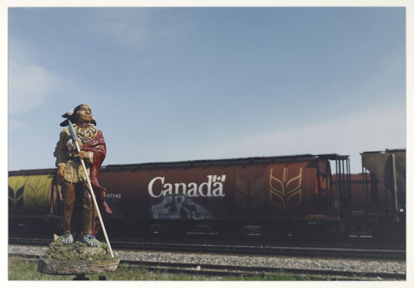
Canada Day 2005, Brandon, Manitoba, Canada, by Jeff Thomas, 2005

First Nations figure set in front of a train marked “Canada” with grain graffiti on its side.

Canada Day 2005, Brandon, Manitoba, Canada from The Delegate on Tour Series by Jeff Thomas, 2005 (MIKAN 3932014) ©Jeff Thomas

For Iroquois artist Jeff Thomas, Canada has always excluded his people. He made this series in order to symbolically place them back in the national picture. Each photograph takes back a major symbol of Canadian nationhood.


Tell us about yourself

I was born and raised in Buffalo, New York, and I am an enrolled member of the Six Nations reserve near Brantford, Ontario. I am a self-taught photographer and curator. My career in photography began from a near-fatal car accident in 1979 that left me with a permanent disability from a spinal cord injury. I turned to my interest in photography to begin the process of rebuilding life. My career began with two objectives: to address the absences of contemporary and of historical Indigenous photographers in archival collections. My primary objective was to address the absence and invisibility of urban-based Iroquois like me.

In 1990, I was living in Winnipeg, Manitoba, when I discovered, during a research project at the Manitoba Museum, that LAC had a complete copy of Edward Curtis’s 20-volume series The North American Indian. Curtis played the role of antagonist in my early career, primarily because of his staged images of an Indigenous tribal life, which had vanished decades before. Very little was known about Curtis—wanting to know more, I moved to Ottawa in 1993 and began the next stage of my career.

Is there anything else about this item that you feel Canadians should know?

In 1999, my son Bear was moving to the West Coast, so I was losing my muse. Bear had started posing for me in 1984. Around the same time that Bear was leaving, I received a box in the mail from documentary filmmaker Ali Kazimi. Ali had made a documentary film about my work titled Shooting Indians: A Journey with Jeff Thomas. Ali introduces the film by holding up a plastic Indian and cowboy. And when I opened the box, I saw the plastic Indians and the cowboy, with a note from Ali saying, “You will find something interesting to do with them.”

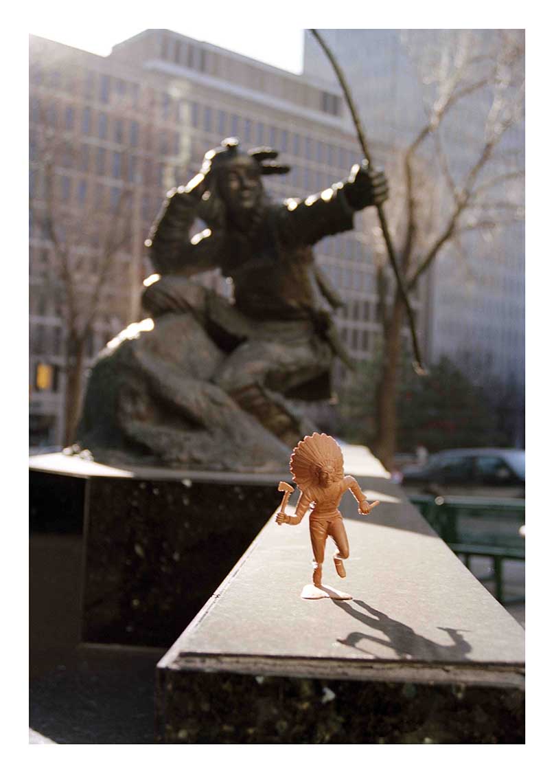
Indians on Tour began in the summer of 2000 during a walk around the Parliament Hill area in Ottawa. I had a plastic toy Indian figure in my camera bag, and when I stopped to photograph a statue of an Indian hunter, I placed the toy Indian in front of the bronze hunter and photographed the two. What transpired when I saw the photograph was a new level of possibilities for me in addressing absences of Indigenous representation in the everyday world. From that point, I started taking the plastic figures with me wherever I travelled. I eventually added new Indian figures that I discovered in tourist shops, and to make posing them less reliant on a flat surface, I started making portable dioramas for the figures, mounted on a portable light stand.

Small light-brown First Nations figure set in front of Indian hunter statue. Tall office buildings and trees can be seen in the background.

War Dancer and Indian Hunter Statue by Jeff Thomas in Ottawa, 2000 © Jeff Thomas

In 2005, I was in Brandon, Manitoba, for an opening of my work, and since the next day was Canada Day, I drove around the city looking for an interesting site to pose the delegate. When I saw the grain car with “Canada” and some graffiti on its side, I knew I had found the site for my Canada Day image.

Tell us about another related item that you would like to add to the exhibition

A black-and-white photo of a Dakota First Nation woman wearing a striped dress under a long beaded breastplate. It is matched with a necklace, long earrings and braids.

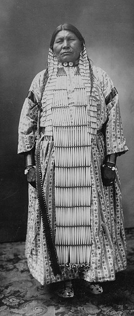
Studio portrait of Dakota First Nation (Sioux) woman (MIKAN 3258922)

In 1994, LAC hired me to write new captions for photographs showing Indigenous people, with culturally insensitive words in the old captions. One image stands out from my project. I wrote a new caption for a photograph showing a full-length image of an Indigenous woman. She was probably a mother, wife, grandmother and elder for her community. The caption was “Sioux Squaw”; squaw is considered a very derogatory word. The caption I wrote was simply “Dakota Woman.”

An important point is that the original caption was not deleted, so researchers will see both captions in the database. The new caption inspired a researcher to try and identify the woman, and the new information he found was subsequently added to the database caption. It was amazing to see the impact that changing two words had on one photograph. I suspect that once more Indigenous people use the database, someone from her community will add her name to the caption.

Biography

A colour photograph of a lightly bearded man smiling at the camera.

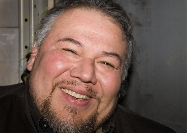
Jeff Thomas credit Justin Wonnacott

Jeff Thomas is an urban-based Iroquois, self-taught photo-based artist, writer, public speaker and curator, living in Ottawa, Ontario. He has works in major collections in Canada, the United States and Europe. Jeff’s most recent solo shows were Mapping Iroquoia: Cold City Frieze, McMaster Museum of Art, Hamilton, Ontario; Resistance Is NOT Futile, Stephen Bulger Gallery, Toronto, Ontario; and The Dancing Grounds, Wanuskewin Heritage Park, Saskatoon, Saskatchewan.

Thomas has also been in many group shows, including l:ke – Toronto: Tributes + Tributaries, 1971–1989, Art Gallery of Ontario, Toronto, Ontario; Land/Slide: Possible Futures, Markham, Ontario; SAKAHÀN, National Gallery of Canada, Ottawa, Ontario; and UNMASKING: Arthur Renwick, Adrian Stimson, Jeff Thomas, Canadian Cultural Centre, Paris, France. In 1998, he was awarded the Canada Council for the Arts’ prestigious Duke and Duchess of York Prize in Photography. He was inducted into the Royal Canadian Academy of Art in 2003. In 2008, he received the Karsh Award in photography.

Related resources

It’s not easy putting Canada on stage – The Centennial Play

By Théo Martin

A little over 50 years ago, Canadian novelist and playwright Robertson Davies co‑wrote The Centennial Play to celebrate the 100th anniversary of Canadian Confederation in 1967. In 1965, with financial support from Canada’s Centennial Commission, Davies began writing the bilingual play featuring Canada’s history with four other renowned Canadian writers: W.O. Mitchell, Arthur L. Murphy, Eric Nicol and Yves Thériault.

A black-and-white photograph of a man smiling while holding a cat near his shoulder.

Robertson Davies and a cat, 1954. Photo: Walter Curtin. Walter Curtin fonds (MIKAN 3959842)

The play was divided into many scenes depicting the regions and provinces of Canada and involving fictional characters and dancers representative of Canada’s diverse linguistic and cultural communities. The play was accompanied by an original score written by Canadian composer Keith Bissell.

Handwritten page with drawings in red ink.

Handwritten draft of the cover page of a draft version of The Centennial Play, with drawings by Robertson Davies, circa 1965 (MIKAN 128551)

Typewritten text with annotations in red ink.

Typescript of The Centennial Play annotated by Robertson Davies, circa 1966 (MIKAN 128551)

Continue reading

Images of moose now on Flickr

Moose are the largest members of the deer family.

A coloured print of two moose calves lying on the ground and an adult bull moose standing next to them.

“Moose Deer,” coloured lithograph by John James Audubon, 1845 (MIKAN 3025621)

They are typically very tall, having long legs to help them wade through water or snow. Other characteristic features include a humped shoulder region, dark-coloured fur, an elongated face with prominent snout and lips, large ears, and broad flat antlers on the male. They inhabit the boreal forests across Canada and similar regions over the world. Preferring a colder climate, they seek out habitats with seasonal snow cover and move further north during the summer months.

Visit the Flickr album now!

Carlyle Smith Beals: a great Canadian astronomer

By François Larivée

Canada’s Dominion Astronomer and the Dominion Observatory

It may be a little-known fact now, but for several decades, Canada had a Dominion  Astronomer. This person was in charge of the Dominion Observatory in Ottawa, located on the Experimental Farm. The observatory was built in 1905 by the Geological Survey of Canada to provide precise temporal and spatial data for its mapping and topographic surveys. In those days, there were no atomic clocks to tell the exact time, so the movements of certain reference stars were used. Spatial coordinates were also determined by observing the precise position of a large number of stars. All of these observations were made using the telescope at the observatory. The Dominion Observatory was in operation until 1970, when its activities were transferred to the National Research Council of Canada.

View of a building under construction. The building’s construction is almost complete, but there is scaffolding in front of the building, and the metal structure of the cupola is still under construction.
The Dominion Observatory in Ottawa under construction, ca. 1905 (a053076)

Documents on the Dominion Observatory are archived in the Department of the Interior fonds and the Natural Resources Canada fonds. In addition, Library and Archives Canada has the fonds of the astronomer who was one of the Observatory’s most important directors, Carlyle Smith Beals (1899–1979), Dominion Astronomer from 1947 to 1964. During his career, Beals garnered international acclaim for his high-quality research and important discoveries. He not only was the director of the Dominion Observatory for nearly 20 years, but also carried out research in the vanguard of his field since the 1930s, when he began his career as assistant astronomer at the Dominion Astrophysical Observatory in Victoria, British Columbia.

A black-and-white photograph of two men standing side by side in doctoral gowns.
C.S. Beal (left) receiving an honorary doctorate from Queen’s University, 1960 (a149328)

From studying very hot stars and interstellar matter to studying impact craters

Beals conducted research at first on certain kinds of hot stars (P Cygni and Wolf-Rayet stars) and the chemical composition of interstellar matter. Among his important discoveries, Beals proved that hot stars are made up of large gas pockets and that interstellar matter is not distributed evenly throughout space. These discoveries were made while Beals was at the Astrophysical Observatory in Victoria, before he went to the Dominion Observatory in Ottawa. Another interesting fact about the Victoria Observatory, which is still in operation, is that when it first opened in 1918, the telescope, with its 1.83-metre-wide mirror, was for some months the largest in the world.

A black-and-white photograph of a cylindrical building, with an observatory cupola, on top of a hill.
Dominion Astrophysical Observatory in Victoria, British Columbia, ca. 1925 (a032169)
A black-and-white photograph of the inside of an observatory.
Telescope in the Astrophysical Observatory in Victoria (a149328)

As Dominion Astronomer in Ottawa, Beals was very active both as a scientist and as an administrator. He was renowned for his research on meteor craters (also called impact craters) in Canada. This research was a key part of his later career and won him worldwide acclaim. After two meteorite impact craters, the Brent crater in Ontario and the New Quebec crater (now called the Pingualuit crater), were identified in the early 1950s, Beals launched a comprehensive program to find meteor craters across Canada. The work involved analyzing thousands of aerial photos from the National Air Photo Library and from National Defence, and conducting geological studies in the field. This extensive research program earned international recognition for Canada.

Continue reading

Images of Yukon now on Flickr

Yukon, located in the northwestern corner of Canada, is one of the country’s three territories. Alaska is to the west, British Columbia to the south, and the Northwest Territories are to the east.

Early humans are thought to have arrived in Yukon at least 20,000 years ago. They eventually developed into Inuit and First Nations groups of the Na-Dene linguistic family.

A black-and-white photograph of the port side of a passenger steamer. People are gathered at the bow and on the second level deck.

Steamer Victorian on the Yukon River near Dawson, Yukon (MIKAN 3299679)

Since Yukon is one of the most remote areas of Canada, Europeans in the fur trade did not arrive in the region until the early 19th century. Rumours of gold brought in miners and prospectors starting in 1874. Then, from 1896 to 1899, the discovery of gold in the Klondike region triggered a rush of migrants. To deal with the large increase in population, the Yukon Territory, formerly part of the Northwest Territories, became a separate entity within the Canadian confederation in 1898.

Yukon’s population declined dramatically in the 20th century, but the construction of highways and a brief revival of mining triggered steady population growth in the 1970s. The economy has diversified to compensate for decreasing profits from mining.

Did you know?

  • The name “Yukon” is derived from the Gwich’in word “Yu-kun-ah,” which means “Great River” and refers to the Yukon River.
  • Yukon is home to the highest mountain in Canada and the second-highest on the North American continent: Mount Logan, 5,959 metres (19,551 feet).
  • Yukon has the smallest desert in the world, located near Carcross. This desert is approximately 2.58 square kilometres (1 square mile).

Visit the Flickr album now!

Images of the Dominion Archives Building now on Flickr

Library and Archives Canada collects and preserves the archives of some of Canada’s most notable architects, architectural firms and organizations. These archives contain many interesting collections, for example, records pertaining to the architects, design and construction of Ottawa’s former Dominion Archives building at 330 Sussex Drive.

A black-and-white photograph of a 3-storey, stone, and mortar building located on a large grassy area.

Public Archives of Canada, Sussex Street, Ottawa, Ontario (MIKAN 3192914)

Early in the first decade of the 20th century, Prime Minister Wilfrid Laurier suggested that the addition of an archives building to the nation’s capital would help “make the City of Ottawa the centre for intellectual development in this country, and the Washington of the North.” The archives building was subsequently constructed between 1904 and 1906, and opened officially in early 1907. This Ottawa landmark housed Canada’s archival heritage until 1967.

Visit the Flickr album now!

See also:

Signatures, Spring/Summer 2017