By Ethan M. Coudenys
Cartography is the practice of drawing or making maps; during the First World War, this was vital for planning and preparing attacks and defensive actions. Battles in France like those of the Marne, Somme and Verdun were mostly planned with large maps by high-ranking officers and non-commissioned members. However, for the battle at Hill 145—better known as Vimy Ridge—cartography played an integral role in the planning of the assault by the Canadian Expeditionary Force (CEF).

Canadians advancing through German wire entanglements, Vimy Ridge, April 1917 (a001087).
Before we begin, we should set the scene by talking about the CEF before the Battle of Vimy Ridge. The Canadians had fought in various battlefields in France and Belgium, including with distinction at Flers-Courcelette (August–November 1916) in France, about 50 kilometres from Vimy. Under the command of Lieutenant-General (later Field Marshal and Governor General) Sir Julian Byng, the CEF had become a very successful fighting force. In November 1916, the Canadians began moving to the east of the French town of Arras. There, they began preparing for an attack on Hill 145, where the German forces had taken nearly three years to build very heavily fortified lines of trenches.
The Battle of Vimy Ridge, which began on April 9, 1917, was not an isolated operation; it was a small part of the Battle of Arras. The two major points of the battle for the ridge, for which the Canadians were responsible, were the ridge itself (Hill 145) and the Pimple (Hill 119). Incredible preparations went into planning this attack.
Between the beginning of the war in 1914 and when the Canadians took up positions in late November 1916, French and Moroccan divisions had tried to take Vimy Ridge. They advanced the allied front line closer to the ridge. During the Battle of Verdun, the British took over these positions, and they expanded and strengthened the relatively weak fortifications. By November 1916, the CEF entered the front line at Vimy with very good fortifications.
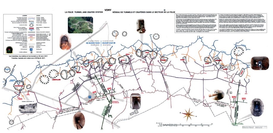
Map 1 – Map of La Folie battlefield: group of tunnels, near Vimy. Courtesy of Veterans Affairs Canada – European Operations.
The Canadians were called to the line at Vimy for the first time as an entire corps, fighting side by side. This was incredibly important not only for the soldiers but also for the young nation. For many, it signified the start of a process whereby Canadians would collectively build their cultural and national identity.
We can better understand the importance of cartography in battle by first reviewing some of the maps that are presented today at the Visitor Education Centre in the Canadian National Vimy Memorial in France. There, Canadian guides—all university and college students—educate the public about the Battle of Vimy Ridge, including the tunnels that were built to support the advance of Canadian troops in April 1917. In maps 1 and 2, the different tunnels and trench lines used during the battle for the ridge are shown.

Map 2 – Battlefield map of the Battle of Vimy Ridge: modern map. Courtesy of Veterans Affairs Canada – European Operations.
How were the maps made?
Maps were important for infantry soldiers because they helped to ground and situate them in an environment marked by constant fear, confusion and proximity of death. During the months leading up to the Vimy Ridge battle, soldiers were sent into the German forces’ trenches to gain information about the enemy’s fortifications and weapon emplacements that lined the front. Moreover, the Royal Flying Corps (later the Royal Air Force) used aerial photography to pinpoint areas of fortifications and map points of interest for the attack. Let us examine this gathering of information by soldiers.
The CEF collected information by sending small incursions into the German lines, with soldiers memorizing the layouts of the other side’s trench systems. These could be completed by a small group of men or a very large group (5,000 or more in one instance) and took place from November 1916 until the eve of the battle in April 1917.
During the infamous trench raids, Canadian soldiers would be tasked with memorizing the layout of the trenches and important locations in the German forces’ lines. These vital recollections were later reflected in detailed maps, which were used by the Canadians to help reduce confusion among the infantry. The trench raids could be incredibly dangerous, both for the men raiding and for the defenders. Often these attacks would take place at night, and both attackers and defenders could suffer heavy losses.
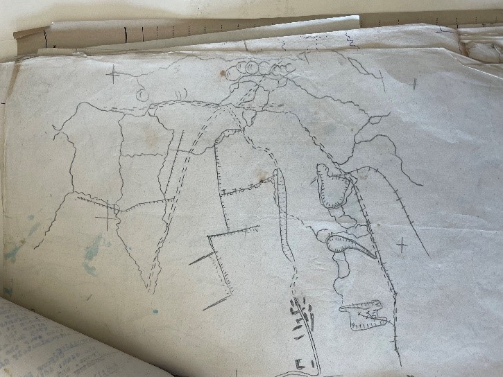
Hand-drawn map of German forces’ trenches after a raid, Vimy Ridge, 1917 (MIKAN 4289412). Photo: Ethan M. Coudenys.
The maps that were created as a result of these raids, such as the example above, were often drawn by hand, from memory, by individual soldiers.
What maps were made?

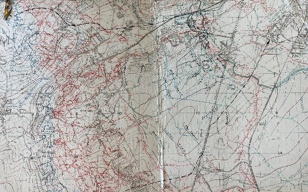
Artillery barrage map, 1st Field Survey Company, Royal Engineers, near Vimy, 1917 (e000000540).
We are very fortunate to have access to a vast number of maps from the Great War in the collection at Library and Archives Canada. Some of the most frequently requested by researchers are the trench line maps of the Western Front. As mentioned above, these maps were drawn through painstaking and sometimes bloody collection of information by soldiers, engineers and pilots. These maps were issued widely to both low-ranking officers and non-commissioned members of the infantry to help them succeed in the attack on April 9, 1917.
The first map issued, and perhaps the most important for the advance, was the barrage map. During the attack on Vimy Ridge, the Canadian artillery, supported by numerous British field artillery units, used the tactic of a rolling (or creeping) barrage to subdue resistance by the German forces while the infantry advanced behind a wall of falling shells. This process was incredibly well timed, and it needed to be, to avoid any friendly fire casualties. Thus, maps were created and used by the artillery units to launch this barrage on the German forces’ lines. These maps detail the targets of the artillery leading up to the four main objectives of the CEF between April 9 and 12, 1917. They show the 100-metre advances of the rolling barrage every three minutes, allowing the infantry units following the barrage to successfully move behind the wall of fire. The maps also show the various targets of particular interest, including fortifications, machine gun emplacements, mortar emplacements and munitions storage areas.
Infantry soldier’s pocket map, made of cardboard, Vimy Ridge, 1917 (MIKAN 4289412). Photo: Ethan M. Coudenys.
The most widely used maps in the attack on Vimy Ridge were those issued to infantry units. These maps were small copies of larger planning maps used by high-ranking officers, but they included the individual objectives of each platoon and company. This was an incredibly important step in planning and executing the attack on the ridge. Despite the confusion caused by gun and rifle fire, the maps helped the advancing soldiers to stay on course.
The change of policy allowing soldiers to carry their own battlefield maps might seem like a minor one, but it had a significant effect on the CEF’s success in the Battle of Vimy Ridge.
Additional resources
- The Underground War: Vimy Ridge to Arras by Phillip Robinson and Nigel Cave (OCLC 752679022)
- Vimy by Pierre Berton (OCLC 15063735)
- Vimy 1917: Canadians and the Underground War by Dominique Faivre (OCLC 1055811207)
Ethan M. Coudenys is a Genealogy Consultant at Library and Archives Canada.