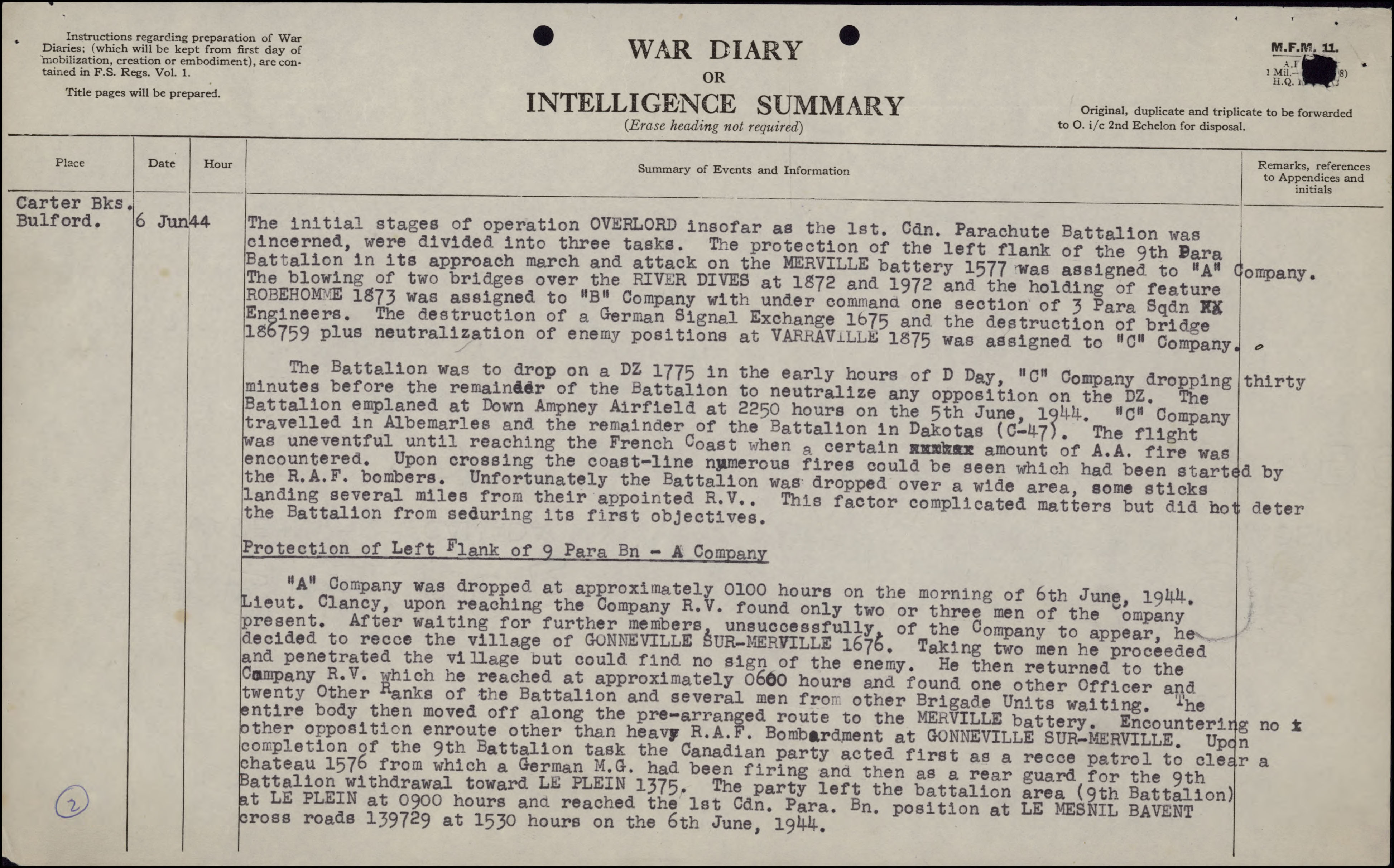
By Emily Potter
William Charles Chaplin, in actual fact—and, yes, the title is misleading. A little like the information you can sometimes find while doing family history research in a First World War file!
In Genealogy Services, one of the most common questions we receive is from clients asking about an ancestor’s First World War service. In many cases, military service is one of the defining stories they have heard about their ancestor, and they are keen to learn more about it.
Military personnel files are also chockful of biographical information and can be a great starting-off point for your genealogy research.
Let’s explore what genealogical information can be gleaned from a file through a fun exercise. For this exercise, I chose a soldier’s personnel file: that of William Charles Chaplin. Keep in mind that, when doing genealogy research, we are looking for names of ancestors, as well as dates or places of key life events, such as births, marriages and deaths. For this exercise, let’s see whether we can find that information for this person. We’ll also see what we can find out about his parents and his spouse.
Searching the personnel file
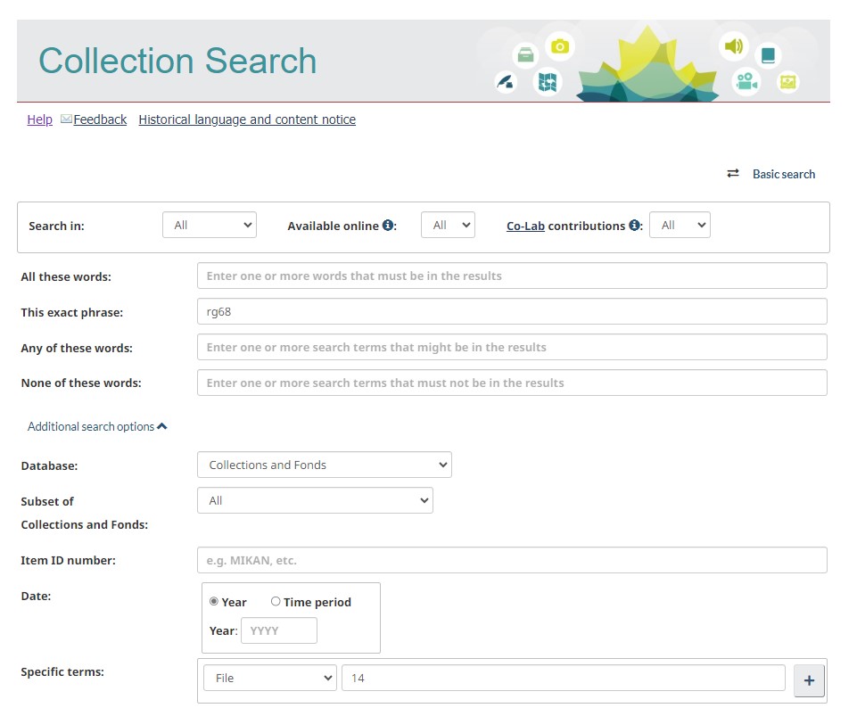
References to the personnel files of Canadian soldiers, nursing sisters and chaplains can be looked up in the Library and Archives Canada (LAC) Personnel Records of the First World War database. The digitized files can be accessed for free.
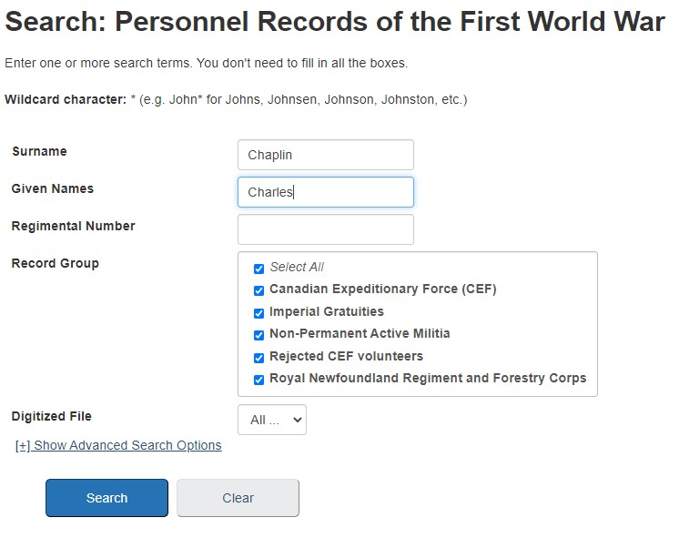
Search screen of the Personnel Records of the First World War database.
We begin by searching the database. At the search screen, enter your ancestor’s surname and given names, and click Search.
As you can see, I chose to search for the name “Charles Chaplin.”
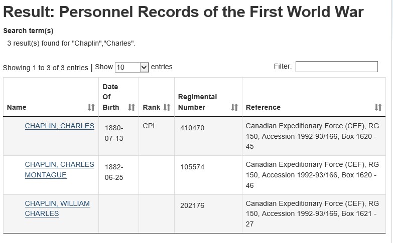
Search results for “Charles Chaplin.”
Review the results to see which reference matches your ancestor. If your ancestor had a common name, this will be more difficult because there could be hundreds of results. Be sure to check out the database’s Search Tips if you’re having trouble.
From the Result screen, I selected the entry “Chaplin, William Charles.”
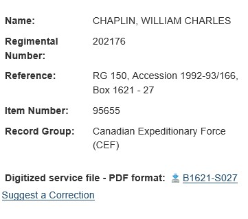
Reference page for “Chaplin, William Charles.”
Once you have clicked on the name, you’ll see the reference information for the file. In most cases, there will also be a thumbnail image of the attestation paper. To access the complete file, click on the link marked “Digitized service file – PDF format.”
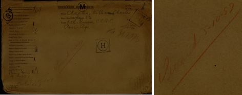
File envelope for William Charles Chaplin, RG150 Accession 1992-93/166, Box 1621 – 27, Image 1.
Among the first images in this digitized file, we see the envelope that held William Charles Chaplin’s physical file. This is where we find our first piece of information. The writing on the envelope indicates that Chaplin died on October 5, 1957.
The exterior of the envelope also includes the note “over age.” This implies that Chaplin was discharged for being too old to serve. In order to enlist, recruits had to be between the ages of 18 and 45, but it was common for men to lie about their age in order to appear eligible to serve. Envelopes aren’t always included in the file, but when they are, they can include helpful information.

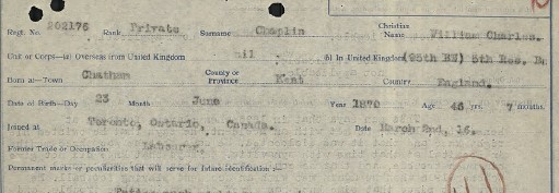
Attestation paper for William Charles Chaplin, RG150 Accession 1992-93/166, Box 1621 – 27, Image 3.
As we move to the third image of the PDF, we see the attestation paper. This is the document that was filled out when a soldier enlisted. This document indicates that Chaplin was born on June 23, 1874. This date may not be accurate because, as mentioned above, the envelope indicated that he was “over age.” It is possible that he lied about his age in order to enlist.
The attestation paper also indicates that he was born in Kent, England, but was living in Toronto at the time of enlistment.
Usually, a parent or spouse is listed as the significant other. In this case, we see that Chaplin has listed his daughter Miriam Chaplin. The reason for this is that his wife had died; this is confirmed by his answer to question seven.
From looking at the second page of the attestation paper, we also discover that Chaplin was Anglican.
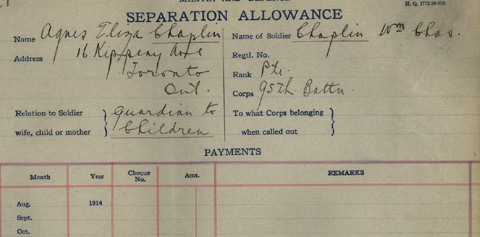
Separation Allowance document for William Charles Chaplin, RG150 Accession 1992-93/166, Box 1621 – 27, Image 17.
Genealogical information is not limited to the attestation paper. Additional details can often be found throughout a service file.
For example, in some cases, when a soldier married while in service, a document showing the change from the soldier’s pay being sent to the mother’s address to its being sent to the wife’s is included in the file.
In this case, on numerous pay sheets, we see the pay being sent to Agnes Eliza Chaplin, who appears to have been the designated guardian of Chaplin’s children.

Examination card for William Charles Chaplin, RG150 Accession 1992-93/166, Box 1621 – 27, Image 35.
On image 35, we get another clue about his age, indicating again that Chaplin was overage when he enlisted. Here we see his age as 46 in October 1916. If we accept his birth date as June 23, this would mean his birth year was in fact 1870, not 1874 as stated on his attestation paper.
![A typed and handwritten document, titled Particulars of Family of an Officer or Man Enlisted in C.E.F. [Canadian Expeditionary Force], from William Charles Chaplin’s service file in the Personnel Records of the First World War database.](https://thediscoverblog.com/wp-content/uploads/2021/08/pic9.jpg)
Particulars of family document for William Charles Chaplin, RG150 Accession 1992-93/166, Box 1621 – 27, Images 45 and 46.
We find out that Chaplin had six children: Marian (also spelled Miriam elsewhere in the file), James, Richard, George, Agnes, and William. The children’s ages are also provided. From looking at the date of the document and knowing their ages, we can guess the approximate year of birth for each of the children.
From the second page of the document, we learn that Chaplin’s father has died and that Agnes Chaplin is his mother. This suggests that the guardian, Agnes Eliza Chaplin, whose name was mentioned in other documents, was his mother because the address provided for her is the same as the one that appears on image 17.

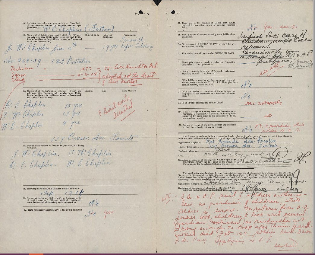
Canadian Expeditionary Force (Information for Separation Allowance Board), William Charles Chaplin, RG150 Accession 1992-93/166, Box 1621 – 27, Image 87.
On images 87 and 88, we come across a document titled Canadian Expeditionary Force (Information for Separation Allowance Board). This document was completed in 1919 by Gertrude Ada Prentice to have Chaplin’s separation allowance and assigned pay transferred to her, as she was now the one caring for the children.
Confusingly enough, the first page of the document indicates that Chaplin’s wife’s name was Eliza Agnes Chaplin and that she passed away on March 1, 1914.
Wasn’t his mother’s name listed as Agnes Chaplin? It is quite possible that they have the same name, but it is also very possible that mistakes were made by those completing the forms.
Page from the CEF service file of William Charles Chaplin, RG150 Accession 1992-93/166, Box 1621 – 27, Image 88.
The first bit of information we find on image 88 is that his son J.W. Chaplin also served in the First World War and that his regimental number was 868139. Presumably, this is James, the eldest son, mentioned on image 45.
It appears that Chaplin’s daughters Agnes and Celia were adopted by Prentice when their mother died. Although not yet formally adopted, the boys were also living in her care at this time.
We also see that the children’s grandmother died in February 1919.
The note at the bottom states the following:
S.A.[separation allowance] and A.P. [assigned pay] paid to soldier’s mother-in-law as guardian of children, while soldier in service. On return from O.S. [overseas] soldier took children to live with present guardian (applicant) as grandmother not strong enough to look after them. Grandmother died Feb. 1919…
The quote above indicates that it was Chaplin’s mother-in-law caring for the children, not his mother. In some ways, this makes more sense. Specifically, the fact that his wife and his mother-in-law share the same given names is more logical because it was quite common to pass down names in a family. Mothers and daughters would sometimes share the same given names, much like fathers and sons.
On the other hand, why would his mother-in-law have the same surname as he does? Perhaps Prentice made an error when stating that the children had been with Chaplin’s mother-in-law and not his mother.
There is definitely an error somewhere in the file, but which is it? Unfortunately, this is the nature of genealogy research: we sometimes find information that simply does not add up.
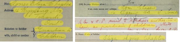
Details from images 21, 46, 88, 87 (clockwise from left) from Chaplain’s service file, RG150 Accession 1992-93/166, Box 1621 – 27.
From the above images, we can see that Agnes Eliza Chaplin, who lived at 16 Kipping Avenue, is indicated as either his mother or mother-in-law at different points in the file.
Let’s have a look at the personnel file of Chaplin’s son James W. Chaplin to see whether it can shed any light on this issue.

Reference page for James William Chaplin from the Personnel Records of the First World War database.
A quick search in the Personnel Records of the First World War database revealed the reference shown in the image above.
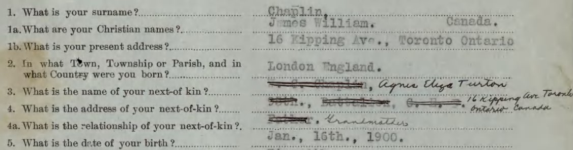
Detail of the attestation paper from James William Chaplin’s service file, RG150, Accession 1992-93/166, Box 1621 – 14, Image 3.
Upon opening the digitized file, there is some immediate clarification. James has listed his next of kin as his grandmother, Agnes Eliza Turton, living at 16 Kipping Avenue, Toronto, Ontario.
This suggests to me that the Agnes Eliza Chaplin in the file was always Agnes Eliza Turton, the mother-in-law of William Charles Chaplin.
But then why was Agnes listed with her last name as Chaplin throughout the file?
It is unclear whether this information was merely a clerical error that was copied several times or his choosing to identify her in this manner because he feared that there would be issues with his pay being sent to someone who was not a blood relation. Unfortunately, we really have no means of knowing.
Detail of a page from William Charles Chaplin’s service file (RG150 Accession 1992-93/166, Box 1621 – 27, Image 97).
Returning to the file of William Charles Chaplin, we come across one last piece of helpful information. On image 97, we have another birthdate for Chaplin, June 23, 1870. This date aligns with the fact that he was discharged for being overage and is most likely more accurate than the date listed on his attestation paper. We also find out that he was born in the town of Chatham.
Let’s review what we have learned about William Charles Chaplin from his file:
- Date and place of birth: June 23, 1870, Chatham, Kent, England
- Date and place of marriage: Unknown
- Date and place of death: October 5, 1957, place unknown
- Mother’s name: Unknown
- Father’s name: Unknown
- Spouse’s name: Eliza Agnes Turton, daughter of Agnes Eliza; died before March 2, 1916
- Children’s names: Miriam, James, Richard, George, Agnes, William, and Celia
This is quite a lot of information to discover about the soldier, not to mention all the information on Chaplin’s children, from looking only at his personnel file. This information includes not only the children’s names but also their ages, from which we can surmise their approximate birth years. We also know that two of his daughters were adopted by a Gertrude Ada Prentice and that she cared for his other children after his mother-in-law died.
Keep in mind that not all personnel files will include this amount of information, but we can definitely see how the files can serve as a great starting point for your genealogy research (and can also include conflicting information!).
We can now use this information to dive deeper into William Charles Chaplin’s family history, by searching other genealogy sources. Continue learning about this in Part II of this blog article.
Emily Potter is a genealogy consultant in the Public Services Branch of Library and Archives Canada.


![On the left of the graphic, Tatânga Mânî [Chief Walking Buffalo] [George McLean] in traditional regalia on horse. In the middle, Iggi and girl engaging in a “kunik”, a traditional greeting in Inuit culture. On the right, Maxime Marion, a Métis guide stands holding a rifle. In the background, there is a map of Upper and Lower Canada, and text from the Red River Settlement collection.](https://thediscoverblog.com/wp-content/uploads/2019/02/blog-banner-1.jpg)