Library and Archives Canada’s “false” portraits

A false portrait is an imaginary portrait, usually of a well-known or famous person. The portrait is usually not based on a true likeness and is often created long after the person’s death.

Extremely significant historical figures often did not sit for portraits during their lifetimes. Yet, there has always been a demand for “true” portraits of them.

False portraits were not necessarily attempting to trick or fool people—in many cases, those who created or promoted them did so for very public-spirited reasons. From the 19th century onwards, this famous false portrait of Samuel de Champlain, the founder of Quebec City, served an important commemorative and educational role.

Lithograph attributed to Louis-César-Joseph Ducornet, 1854. It shows an image of a man facing slightly away from the viewer. He wears a black doublet with sleeves that reveal a white shirt underneath. In the background is a view of Quebec City.

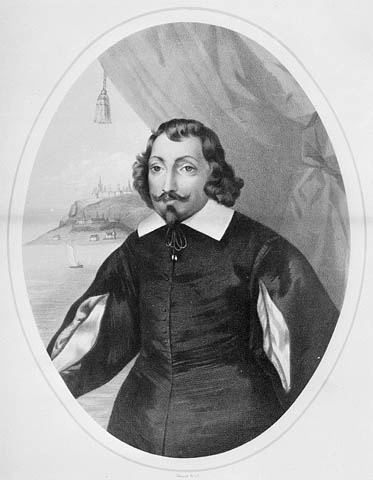
False portrait of Samuel de Champlain (MIKAN 2919672)

A false portrait often tells us a lot more about the society that created it than about the historical figure that it is meant to represent. It has been suggested that this pious-looking image made the perfect frontispiece to 19th-century histories of New France, developed by historian-churchmen. It doesn’t seem to have mattered that the portrait is actually copied from a 17th-century engraving of a French civil servant, whose morality was dubious (in French only).

Library and Archives Canada (LAC) holds other intriguing false portraits in its collections. For example, LAC acquired this rare miniature wax portrait, one of very few portraits in this fragile medium to survive.

Wax miniature, by an anonymous artist, early 19th century. This rather generic wax miniature shows a man in profile wearing a red British coat embellished with gold trimming, a white cravat and a blue waistcoat. He has long white hair, tied back. The miniature is quite sculptural.

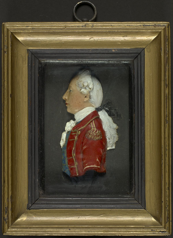
Wax portrait of General James Wolfe (MIKAN 3793977)

Though labelled a portrait of General James Wolfe, famous for his role during the decisive Battle of Quebec (1759), the miniature does not reproduce any of Wolfe’s known physical features. Yet several near identical wax miniatures exist in other collections—each of these also labelled, in the past, as Wolfe portraits. It’s possible to speculate that many casts of this portrait must have been made, for so many fragile examples to have survived.

Wax was cheap and easy to produce in multiple copies. The portrait was likely created as a kind of mass-produced celebrity image, in response to a vast appetite for portraits of “Wolfe the Hero” that arose among the general public during the 19th century. Probably created long after Wolfe’s death by an anonymous entrepreneur, it presents an idealized and heroic-looking profile view of a young officer—exactly the kind of image guaranteed to satisfy the public imagination.

Samuel de Champlain’s General Maps of New France

In the fall of 1612, Samuel de Champlain had an engraving of his first detailed map of New France made in Paris. The map contained new geographic information, based on his own explorations from 1603 onward. The site of Montreal is clearly identified. Using information obtained from Aboriginal peoples, he was able to include previously uncharted areas, such as Lake Ontario and Niagara Falls. He also made use of other maps to depict certain regions, including Newfoundland. Although the engraving was made in 1612, the map was not published until the following year as an appendix to Voyages, Champlain’s 1613 account of his journeys.

Carte geographique de la Nouvelle Franse faictte par le sieur de Champlain Saint Tongois cappitaine ordinaire pour le roy en la marine. Faict len 1612.

Carte geographique de la Nouvelle Franse faictte par le sieur de Champlain Saint Tongois cappitaine ordinaire pour le roy en la marine. Faict len 1612.(e010764733)

While back in France in the summer of 1613, Champlain had an engraving made of a second version of a general map that he had begun the previous year, which he also published in his 1613 book. In that map, he incorporated his most recent geographic findings, including the Ottawa River, which he was the first to depict. His depiction of Hudson Bay was deliberately inspired by a map of Henry Hudson’s voyages.  

Carte geographique de la Nouvelle Franse en son vray meridiein. Faictte par le Sr Champlain, Cappine. por le Roy en la marine – 1613.

Carte geographique de la Nouvelle Franse en son vray meridiein. Faictte par le Sr Champlain, Cappine. por le Roy en la marine – 1613. (e010764734)

An incomplete general map by Champlain also exists. The engraving was made in 1616, although the map was never published. The only known copy is held by the John Carter Brown Library.

In 1632, Champlain published his last major map of New France, which was included in his final book, Les Voyages de la Nouvelle France occidentale, dicte Canada. He had been living in France for nearly three years, having been driven out of Quebec by the Kirke brothers in 1629. This updated map contains little new information verified by Champlain himself, as his own explorations came to an end in 1616. He based the revised version on the invaluable information conveyed to him by others, chief among them Étienne Brûlé. Nevertheless, this map represents an important milestone in the history of North American cartography and was widely used by other mapmakers. There are two versions of this map. Among the differences between them are the representation of Bras d’Or Lake or a chain of mountains on Cape Breton Island. Both versions of the map are held by Library and Archives Canada. The first can be seen here:

Carte de la Nouvelle France, augmentée depuis la derniere, servant a la navigation faicte en son vray meridien, 1632.

Carte de la Nouvelle France, augmentée depuis la derniere, servant a la navigation faicte en son vray meridien, 1632. (e010771375)

Suggested reading to learn more about this subject: Conrad E. Heidenreich and Edward H. Dahl, “Samuel de Champlain’s Cartography, 1603-32”, in Raymonde Litalien and Denis Vaugeois, eds., Champlain: The Birth of French America. Sillery: Les éditions du Septentrion; and Montreal and Kingston: McGill-Queen’s University Press, 2004, pp. 312-332.