Breaking ground: 150 years of federal infrastructure in British Columbia – Lower Mainland Region: Customs Examining Warehouse

By Caitlin Webster

British Columbia joined Canada 150 years ago, and in the years that followed, federal infrastructure expanded throughout the province. This infrastructure is well documented throughout Library and Archives Canada’s collections. This eight part blog series highlights some of those buildings, services and programs, as well as their impact on B.C.’s many distinct regions.

While many locals and tourists can spot the distinctive clock tower of Vancouver’s former post office at Hastings and Granville, few step around the corner to see the classically inspired architecture of the Customs Examining Warehouse on Howe Street.

Black-and-white photograph of the exterior of the Customs Examining Warehouse in Vancouver, B.C. There is a wooden sidewalk in the foreground, and horse-drawn carts are delivering goods to the building entrance.

Examining [or Customs] Warehouse, Vancouver, B.C. (a046650-v8)

In the boom years leading up to the First World War, increasing trade led to the need for more substantial customs warehouse facilities in cities across Canada. In 1908, the federal government approved the purchase of a Vancouver warehouse site for $75,000. Located on the traditional territory of the Musqueam, Squamish and Tsleil-Waututh First Nations, the building served as an annex to the post office. It is one of four federally owned buildings on the site.

Document outlining the decision to purchase land to build an examining warehouse in Vancouver. The document is signed by Prime Minister Wilfrid Laurier.

1908 Order in Council to purchase a site for an examining warehouse in Vancouver (e010701436 )

As one of eight new customs houses built across the country, the Vancouver warehouse shared many design elements with counterparts in Montréal, Calgary, Edmonton, Winnipeg and Port Arthur. Public Works Chief Architect and his team selected a classically inspired façade with a rusticated stone base, rectangular windows, a heavy cornice at the roofline, and ornamental brick pilasters to give the appearance of supporting columns. Constructed from 1911 to 1913, the building was also one of the first structures in Vancouver to use modern steel framing and reinforced concrete floors.

Black-and-white photograph showing the construction of the Customs Examining Warehouse in Vancouver. The lower section has a stone exterior, and the upper section has a steel structure and unfinished brickwork.

The Examining [or Customs] Warehouse [under construction], Vancouver, August 5, 1912 (a046662-v8 )

In 1983, the federal government formally recognized the Customs Examining Warehouse as a heritage structure, along with the adjoining Post Office, Winch Building and Federal Building. The Department of Public Works then began an ambitious conservation project, connecting all four buildings with a glass atrium. Completed in time for Expo 86, the complex is now known as Sinclair Centre, in honour of politician and businessperson James Sinclair (1908–1984). Sinclair Centre currently houses several federal government offices and many retail shops and businesses.

This marks the end of our series highlighting early infrastructure in British Columbia. While federal infrastructure projects varied according to the needs of the diverse geographical areas of B.C., increasing settlement was often the impetus for these expanded federal services. This settlement and accompanying federal infrastructure led to significant and continuing impacts on local First Nations and Métis communities. It also changed the landscape of towns, cities and rural areas across the province. Explore Library and Archives Canada’s extensive collections to discover more about how B.C. has transformed over the 150 years since joining Confederation.


Caitlin Webster is a senior archivist in the Reference Services Division at the Vancouver office of Library and Archives Canada.

Breaking ground: 150 years of federal infrastructure in British Columbia – Vancouver Island Region: Dominion Astrophysical Laboratory

By Caitlin Webster

British Columbia joined Canada 150 years ago, and in the years that followed, federal infrastructure expanded throughout the province. This infrastructure is well documented throughout Library and Archives Canada’s collections. This eight part blog series highlights some of those buildings, services and programs, as well as their impact on B.C.’s many distinct regions.

While astronomical research predates Confederation, federal investments in the field began in earnest in the early 20th century. After the construction of an observatory in Ottawa in 1905, astronomer John Stanley Plaskett began advocating for a state-of-the-art reflecting telescope. This led to the construction of the Dominion Astrophysical Observatory in Saanich near Victoria, British Columbia. The observatory in B.C. was once the world’s largest telescope facility.

The Dominion Astrophysical Observatory is located in the traditional territories of the Xwsepsum (Esquimalt), Songhees, Tsartlip, Pauquachin, Tsawout, Tseycum and Malahat Nations. Their ancestors were signatories of the Douglas treaties of the 1850s, also known as the Fort Victoria treaties. Differences between the treaty text and the oral histories of the First Nations signatories have led to continuing debate as to whether the treaties were land sales or peace agreements.

Land clearing and construction at the site began in 1914 and continued despite the challenges posed by the First World War.

Black-and-white photograph of a group of men posing with a team of horses attached to a wagon carrying part of a telescope.

Hauling 9.5-ton polar axis to the Dominion Astrophysical Observatory, circa 1916–1917 (a149324-v8)

Work on the observatory sparked interest internationally as well as locally. The site became a tourist destination as residents visited to observe the progress and attend the official opening in 1918.

Black-and-white photograph of a large group of people inside the Dominion Astrophysical Observatory for its opening ceremony. The group is gathered in front of the telescope and on the viewing platform.

Opening ceremony of the Dominion Astrophysical Observatory; view of the telescope (a149323-v8)

With the world’s largest operational telescope at their disposal, Plaskett and his fellow astronomers wasted no time in beginning an ambitious observation program. Specializing in binary stars and later focusing their sights on the Milky Way, the team made extensive contributions in the study of astronomy. Successive teams have continued this vital work, and today the Dominion Astrophysical Observatory is one of two observatories managed by the Herzberg Astronomy and Astrophysics Research Centre.

Black-and-white photograph of the exterior of the Dominion Astrophysical Observatory.

Dominion Astrophysical Observatory (a032169-v6)

The observatory engaged with the public and continues to do so. In the 1920s and 1930s, observatory staff contributed to ongoing local newspaper columns and radio broadcasts on astronomical topics of the day. Today, the charitable organization Friends of the Dominion Astrophysical Observatory promotes public outreach activities at the observatory and the Centre of the Universe visitors centre.


Caitlin Webster is a senior archivist in the Reference Services Division at the Vancouver office of Library and Archives Canada.

Breaking ground: 150 years of federal infrastructure in British Columbia – Kootenay Region: Rossland Post Office

By Caitlin Webster

British Columbia joined Canada 150 years ago, and in the years that followed, federal infrastructure expanded throughout the province. This infrastructure is well documented throughout Library and Archives Canada’s collections. This eight part blog series highlights some of those buildings, services and programs, as well as their impact on B.C.’s many distinct regions.

In the pre-war years of the early 20th century, Canada saw unprecedented growth, both in its population and its federal infrastructure. As the population increased by 64 percent between 1900 and 1914, demand for expanded federal institutions grew as well, and the federal building inventory tripled in size.

Much of this growth was taking place in newly established towns such as Rossland, a mining town in southeastern British Columbia. Like many small towns in Canada, it received a substantially built post office in the early 1900s. Due to the great volume of construction across the country, many of these buildings shared common architectural elements. The 1903 Rossland Post Office followed this standard design, featuring a steeply pitched and truncated roof, round-arched openings, and gables with ornamental parapets.

Black-and-white photograph of the exterior of the post office building. Small groups of men and children stand at the building’s unfinished entrance and one of its unfinished windows.

Post office [under construction], Rossland, B.C. (a046453-v8)

With the outbreak of the First World War, economic growth abruptly ended. As a result, many of these federal buildings acquired an unexpected prominence in small towns. Some buildings became city halls or other municipal buildings, while others, like the Rossland Post Office, retained their original purpose.

The federal buildings of this era were prominent due to the quality of their construction and the building materials chosen. In most instances, the Department of Public Works avoided the use of wood and instead chose iron, stone, brick and other sturdy materials. The goal of this approach was to protect federal assets against fire and other hazards, and to serve as an example of quality construction in their various communities.

Unfortunately, the use of such materials provided only partial protection for the Rossland Post Office. On March 1, 1929, what became known as the “Big Fire” swept through the town’s business district. The blaze destroyed all of the wood-frame buildings between the Bank of Montreal and the post office. Firefighters used dynamite on some structures in an attempt to create a firebreak, which unfortunately destroyed all of the post office windows and hastened the fire damage to the structure.

Rossland’s Big Fire, March 1–2, 1929 (a046410-v8)

In the end, the Rossland Post Office lost its distinctive roof with ornate gables. However, the stone-and-brick construction enabled the restoration of the two remaining floors. The prominent structure still serves as the city’s post office, and it is now part of Rossland’s Official Heritage Register.

To learn more about the architectural styles of federal buildings, see Crown Assets: The Architecture of the Department of Public Works, 1867–1967, by Janet Wright, 1997 (OCLC 1017536309).


Caitlin Webster is a senior archivist in the Reference Services Division at the Vancouver office of Library and Archives Canada.

Breaking ground: 150 years of federal infrastructure in British Columbia – Thompson–Okanagan Region: Summerland Experimental Farm

By Caitlin Webster

British Columbia joined Canada 150 years ago, and in the years that followed, federal infrastructure expanded throughout the province. This infrastructure is well documented throughout Library and Archives Canada’s collections. This eight part blog series highlights some of those buildings, services and programs, as well as their impact on B.C.’s many distinct regions.

While farming methods have evolved over millennia, the turn of the 20th century saw an increased focus on agricultural science in Canada. In 1886, the federal government established a network of agricultural research sites to study and promote modern methods of farming. This Experimental Farm Service conducted research on a variety of horticultural subjects, including soil management, livestock breeding and care, and crop research.

Given that British Columbia’s diverse landscape and climate support a wide variety of agricultural activities, the Experimental Farm Service set up farms across the province, including a site in Summerland, on the west side of Okanagan Lake. The Department of Agriculture purchased land from the SnPink’tn (Penticton Indian Band) and set up an irrigation agreement with the town of Summerland to establish the farm site.

Black-and-white photograph of the Summerland Experimental Farm, with young orchard trees in the foreground, and Okanagan Lake and rangeland in the background.

Summerland, B.C. (a020963)

The earliest tasks for the farm included clearing and breaking land, picking stones from the soil, and constructing buildings and an irrigation flume. As the semi-arid climate was well suited for growing tree fruits, an orchard was quickly established, and staff grew ground crops between the rows as the trees slowly matured. In the early years, staff also conducted studies on animal care with poultry, dairy cows and beef cattle, as well as sheep. Ornamental gardens were created in 1916, and they remain a popular site for locals and tourists.

In 1935, researchers from the National Research Council worked at the farm to investigate claims that pollution from a lead and zinc smelter in Trail, B.C., was damaging crops in Washington State. The team used the farm’s food processing laboratory to study the issue and determined that the crop failures stemmed from a boron deficiency in the soil, common in the area.

Black-and-white photograph of three men next to a greenhouse structure. One man is holding a mass of vegetation that obscures his upper body.

Experimental station for smelter fumes at Summerland Experimental Farm, September 1935 (a014567-v8)

In later years, the farm focused its research on the cultivation of tree fruits and grapes, as orchards, vineyards and wineries play an important role in the Okanagan economy. Throughout its history, the farm has been instrumental in developing many varieties of fruits, including Spartan apples, Coronation grapes and Stella cherries.

The experimental farm is now known as the Summerland Research and Development Centre. Its research aims to help the horticultural sector adapt to climate change and other challenges in the physical environment, respond to plant diseases and other biological threats, and expand their contributions to the economy and the community. The non-profit group Friends of the Summerland Ornamental Gardens now manages the historic public gardens.


Caitlin Webster is a senior archivist in the Reference Services Division at the Vancouver office of Library and Archives Canada.

Breaking ground: 150 years of federal infrastructure in British Columbia – North Coast: Dryad Point lighthouse

By Caitlin Webster

British Columbia joined Canada 150 years ago, and in the years that followed, federal infrastructure expanded throughout the province. This infrastructure is well documented throughout Library and Archives Canada’s collections. This eight part blog series highlights some of those buildings, services and programs, as well as their impact on B.C.’s many distinct regions.

With Canada’s long coastlines and countless navigable lakes, lighthouses have been fixtures in the country for hundreds of years. After British Columbia joined Confederation in 1871, the need for an expanded system of navigational aids on the often-dangerous West Coast became increasingly important. The newly created federal Department of Marine and Fisheries took responsibility for an ambitious construction program, and by 1914, Canada had tripled its inventory of lighthouses throughout the country.

Most of these new lighthouses were constructed of timber, and the lighthouse at Dryad Point was no exception. Originally built in 1899, it comprised a lightkeeper’s dwelling attached to a square wooden tower. Reconstructed in 1919, the current lighthouse is a reinforced concrete tower 24 feet (7.3 metres) high.

Black-and-white photograph of a lighthouse tower and attached building. There are some small rough outbuildings in the foreground and the ocean in the background.

Lighthouse tower and dwelling, Dryad Point, B.C., 1929 (a148037-v8)

In 1930, a new dwelling and boathouse were constructed; the light station currently includes a number of accompanying buildings: dwellings, greenhouses, fuel storage and equipment sheds.

Black-and-white photograph of a lighthouse tower, a residence, a boathouse and other buildings, with the shoreline in the foreground.

Light station [Dryad Point], 1935 (a149341-v8)

Located on the northeast corner of Campbell Island near Bella Bella, the lighthouse sits on the traditional territory of the Heiltsuk Nation. Its earliest lightkeeper was the Heiltsuk leader, artist and boat builder Captain Richard Carpenter (1841–1931), who was keeper until 1930.

Since its original construction, the light station has been guiding vessels through potentially dangerous tight turns and low-lying lands at Main Passage and Seaforth Channel. Dryad Point was designated a Heritage Lighthouse in 2015, preserving its unique character and setting.

To learn more about lighthouses and lightkeepers in B.C., check out the following resources:


Caitlin Webster is a senior archivist in the Reference Services Division at the Vancouver office of Library and Archives Canada.

Breaking ground: 150 years of federal infrastructure in British Columbia – Cariboo Region: Railway Mail Service, Prince George to Prince Rupert

By Caitlin Webster

British Columbia joined Canada 150 years ago, and in the years that followed, federal infrastructure expanded throughout the province. This infrastructure is well documented throughout Library and Archives Canada’s collections. This eight part blog series highlights some of those buildings, services and programs, as well as their impact on B.C.’s many distinct regions.

After British Columbia joined Confederation in 1871, the extension of rail service to the province allowed the freer movement of people and goods within B.C. and to other parts of Canada. This included the transport of mail for individuals, organizations and businesses. Trains have carried mail since their invention, but in 1897, the federal government officially formed the Railway Mail Service within the Post Office Department.

Departmental order from Deputy Postmaster General William White, dated February 22, 1897, announcing the establishment of the Railway Mail Service Branch. The announcement includes the initial locations and other details regarding the service.

Department Order, No. 38 [Establishment of the Railway Mail Service Branch] (e002151860)

This service used a system of travelling post offices aboard trains, staffed by crews of specialized railway mail clerks. These clerks performed the regular work of receiving, sorting, cancelling and distributing mail, all done while on board trains travelling from town to town. Clerks needed to be speedy, accurate, strong and trustworthy as they prepared often-valuable items for the mail service. Especially tricky was the pickup of mailbags on the fly. The clerk would swing out a catch arm on the side of the rail car to pick up the waiting bag, while simultaneously kicking out a delivery mailbag for that location. The manoeuvre was particularly challenging if the train was running late and going by a station at full speed.

Railway mail cars had various configurations, but all were fitted with dumping tables, sorting cases and other furniture for preparing mail, as well as stoves, toilets and sinks. Although this made for cramped quarters, such equipment was an absolute necessity for crews who often lived on board the cars for long runs.

Black-and-white photograph of a young man beside tables and mailbags in a railway mail car.

Portrait of railway mail clerk A.L. Robinson on the Grand Trunk line’s first Prince George–Prince Rupert run, 1914 (s002386)

In B.C.’s Cariboo region, railways and the accompanying railway mail service arrived somewhat later than in other parts of the province. In 1914, the Grand Trunk Pacific Railway completed a line from Prince George to Prince Rupert as part of its larger network. The company located the terminus of the line on the traditional lands of the Ts’msyen at Prince Rupert, and it purchased 553 hectares of Lheidi T’enneh land to form the new town site of Prince George. However, by 1915, the company was in financial trouble, and the federal government nationalized the railway and integrated it into Canadian National Railways in 1920.

Colour map of Canada and the northern portion of the United States, showing various railway lines across the continent.

Map showing the Grand Trunk Pacific Railway and the lines of the Grand Trunk Railway system in Canada; also the relative position of the Grand Trunk Pacific to the three northern transcontinental lines now completed: Canadian Pacific Railway, Great Northern Railway and Northern Pacific Railway, 1903 (e01751895-v6)

The Railway Mail Service reached its peak in 1950, when it employed 1,385 railway clerks on lines all across the country. However, the service was in decline by the mid-1960s, and while some mail was still carried by rail up to the 1980s, the Railway Mail Service officially ended in 1971.

To learn more about the Railway Mail Service, railways in B.C., and the purchase of the Lheidi T’enneh land for the Prince George town site, check out the following resources:


Caitlin Webster is a senior archivist in the Reference Services Division at the Vancouver office of Library and Archives Canada

Breaking ground: 150 years of federal infrastructure in British Columbia – Peace River Region: RCAF Fort St. John

By Caitlin Webster

British Columbia joined Canada 150 years ago, and in the years that followed, federal infrastructure expanded throughout the province. This infrastructure is well documented throughout Library and Archives Canada’s collections. This eight part blog series highlights some of those buildings, services and programs, as well as their impact on B.C.’s many distinct regions.

Public airports have been a constant in Canada since the 1920s, when purpose-built facilities replaced the rudimentary airfields and landing strips of the early days of flight. However, the Second World War led to a marked increase in civilian and military airport construction.

In the late 1930s, the Department of Transport constructed a basic airfield in Fort St. John, British Columbia. Located on the traditional territories of the Treaty 8 First Nations, the airfield served as part of a transport route through Grande Prairie, Fort St. John, Fort Nelson, Watson Lake and Whitehorse. When the United States entered the Second World War in 1941, this route offered a strategic location for transportation to Alaska, and for the construction of the Alaska Highway. As a result, in 1943 the U.S. Air Force completely rebuilt the airport in Fort St. John, with resurfaced runways, new fuel facilities, hangars, barracks and accompanying buildings.

: Black-and-white photograph of the administration building at RCAF Fort St. John, B.C. Various individuals stand at attention as three men raise a flag. Several buildings and other structures are also in the background.

Administration building at RCAF Fort St. John, B.C. (e011309348)

RCAF Fort St. John opened in 1943, with personnel performing such duties as maintaining runways and buildings, facilitating incoming and outgoing flights, and monitoring weather conditions. Personnel at the detachment were involved in flights to help the Halfway River First Nation during a 1949 diphtheria outbreak by airdropping supplies of anti-toxin, and by airlifting individuals to medical centres for treatment.

Staff at the detachment also participated in popular outdoor activities in the area, such as picnics, swimming, hunting and fishing. In addition, the station organized teams to play in local amateur sports leagues, including baseball and hockey. However, in the summer of 1948, a polio outbreak in the area forced the station to cancel many of these activities. Certain sections of the station itself were quarantined from July to September of that year due to polio outbreaks among staff.

: Page from a Royal Canadian Air Force operations record book, with columns indicating place, date, time and reference to appendices. Entries on the page are for RCAF Fort St. John, and they date from June 9, 1948, to June 20, 1948.

Page from Royal Canadian Air Force operations record books, including a note indicating the cancellation of Air Force Day due to a local polio outbreak (RG24-E-7; image found on Heritage Canadiana)

By 1950, activity at the station was winding down, and on October 1, 1950, RCAF Fort St. John was officially disbanded. The RCAF funded its maintenance costs until March 31, 1951. In April 1951, it transferred responsibility for the airport to the Department of Transport. Today, the North Peace Regional Airport serves as an important gateway for business and tourism in the area.

To learn more about RCAF Fort St. John, check out the Royal Canadian Air Force operations record books, which contain details of daily duties, flying operations, events and social activities for various units. Microfilm copies of the records are available online, including entries for RCAF Fort St. John on reels C-12185 and C-12399.


Caitlin Webster is a senior archivist in the Reference Services Division at the Vancouver office of Library and Archives Canada.

Breaking ground: 150 years of federal infrastructure in British Columbia – Northwest Region: The Dominion Telegraph Service’s Yukon Telegraph Line

By Caitlin Webster

British Columbia joined Canada 150 years ago, and in the years that followed, federal infrastructure expanded throughout the province. This infrastructure is well documented throughout Library and Archives Canada’s collections. This eight part blog series highlights some of those buildings, services and programs, as well as their impact on B.C.’s many distinct regions.

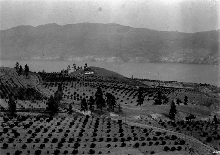
As British Columbia negotiated its terms for joining Confederation, one of the conditions included the establishment of a telegraphic service. Canada’s Dominion (or Government) Telegraph Service, which formed part of the Department of Public Works, was responsible for providing this. It operated telegraph lines in remote areas not covered by railway telegraph systems or private firms. In B.C., the federal government operated lines in the south and on Vancouver Island, and as it expanded its presence in northern B.C. and Yukon in the 1890s, work began on the Yukon Telegraph Line.

In 1899, the Privy Council Office approved the construction of a telegraph line between Dawson City in what is now Yukon and Bennett, B.C. Now a ghost town, Bennett was once a thriving centre for the Klondike Gold Rush.

Black-and-white photograph of the town of Bennett, B.C., at the edge of Bennett Lake. There are buildings and temporary structures along the shoreline, with a mountainside in the background and a wooden bridge in the foreground.

Part of Bennett, B.C. (a016295-v8)

Soon after the line to Bennett was completed, work began on a branch line to Atlin, and then an extension from Atlin to the transcontinental line at Quesnel. This work finished in 1901, although the construction of various branch lines continued over the next decade. As the construction work progressed, the Department of Public Works built telegraph offices and stations at regular intervals along the line. Stations in towns and settlements often housed other federal government services such as post offices and customs houses. Operators at these stations worked regular business hours and enabled customers to send and receive telegrams.

Black-and-white photograph of the three-storey post office building in Atlin, B.C. A sign on the building reads “Dominion Government Telegraph Office.”

Post office in Atlin, B.C. (a046672-v8)

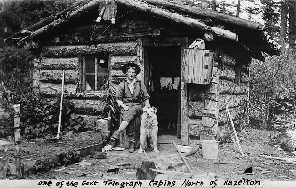
To help ensure that the line had sufficient voltage to carry telegraph messages between the stations, crews also constructed intermediate battery stations, also known as repeater stations, along the more remote sections of the line. At first, these “bush stations” were simple one-room cabins, housing both the assigned operator and the lineman. As these sites rarely saw customers requesting telegrams, both operators and linemen undertook the difficult work of keeping the telegraph wires in good order. In the summer of 1905, crews built second cabins at these isolated stations to ease some of the difficulties of living in such close quarters.

Black-and-white photograph of a young man and his dog sitting in front of a one-room log cabin.

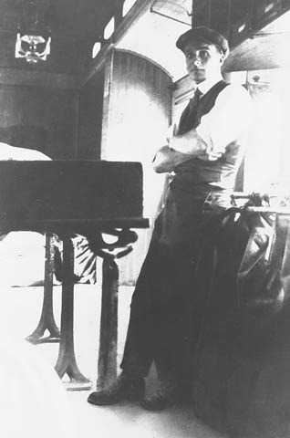
One of the government telegraph cabins [Dominion Government Telegraph cabin, North of Hazelton; telegraph operator Jack Wrathall and dog sit in front of the cabin] (a095734-v8)

Even smaller were the refuge cabins, where linemen could stay overnight if caught in bad weather while maintaining the line. Spaced approximately 10 miles (16 kilometres) apart, these small 8 x 10-foot (2.4 by 3 metres) cabins contained a stove, bunk and limited food supplies.

The telegraph lines affected local First Nations, ranging from the Lhtako Dene, Nazko, Lhoosk’uz Dene and ?Esdilagh Nations near Quesnel to the Taku River Tlingit First Nation in Atlin. Early work on telegraph lines in the 19th century often proceeded without consultation or agreements with First Nations, which led to confrontations when work crews trespassed on their land. A number of First Nations made use of materials left from earlier abandoned telegraph lines, using the wire on bridges and traps. Some First Nations men worked on the telegraph lines, serving as construction workers, linemen and pack-train operators. The most famous among them was Simon Peter Gunanoot, who helped to construct the line and later worked delivering provisions to the bush stations. Accused of murder in 1906, he evaded searchers for 13 years before turning himself in. At his trial in 1919, a jury acquitted him in a mere 15 minutes, and his remarkable story has since inspired books, documentaries and short films.

By the 1920s and 1930s, the federal government began replacing telegraph lines with radio and telephone communications. At the same time, interest in the line as a trail for adventure hiking grew. While the federal government sold off or abandoned the last portions of the Yukon Telegraph Line by 1951, parts of the line are still used by guide outfitters today.

To learn more about the Yukon Telegraph Line, check out the following resources:

  • “A socio-cultural case study of the Canadian Government’s telegraph service in western Canada, 1870–1904,” John Rowlandson thesis, 1991 (OCLC 721242422)
  • Wires in the Wilderness: The Story of the Yukon Telegraph, Bill Miller, 2004 (OCLC 54500962)
  • Pinkerton’s and the Hunt for Simon Gunanoot: Double Murder, Secret Agents and an Elusive Outlaw, Geoff Mynett, 2021 (OCLC 1224118570)

Caitlin Webster is a senior archivist in the Reference Services Division at the Vancouver office of Library and Archives Canada.