Looking for Captain Evans

By Rebecca Murray

When I was a relatively new acquisition at LAC, a mainstay of archival humour used to refer to new employees, I worked on a question from a researcher who was looking for the given names of a captain who served in the Canadian militia in the 1890s. Full of optimism and energy, I set off in search of this elusive captain.

The researcher knew that, during this time, Evans was stationed in Manitoba, where he was also involved with amateur hockey. After unsuccessful keyword searches in our catalogue, I decided to switch strategies and “follow the money.” Not just an oft-quoted phrase, using financial documents or reports such as pay or purchase records is one of many search strategies you might use to find mentions of otherwise elusive individuals or projects. During this period in Canadian history, the militia was significant, but it was still relatively small in comparison with today’s military. Considering this and knowing about the reporting detail available in the annual reports of the Auditor General and departments from this period, I thought I might be able to find some mention of this Captain Evans.

I scoured reports from the early 1890s and was soon successful. I found a reference to a “Lieutenant T. D. B. Evans” attached to the Mounted Infantry School at Winnipeg, Manitoba (Military District 10) in 1891–1892 in the Auditor General’s annual report (c. 1893).

Typed page of text and numbers. Red circle to draw attention to name of “Mounted Infantry School” and the associated name “Evans, T. D. B., Lieut.”

Sessional Papers of the Dominion of Canada: volume 1, third session of the seventh Parliament, session 1893, page 1-C-48 [Ottawa: S.E. Dawson, 1893] (OCLC 858498599)

I then looked at the 1894 report (which covers the period 1892–1893), where I found a similar reference, but this time for a Captain Evans. I scanned the lists of names for others with the same surname (Evans being a common name) and found no others. I continued my search for further details using these initials.

Typed page of text and numbers. Red circles to draw attention to name of “Winnipeg Mounted Infantry School” and the associated name “Capt. Evans.”

Sessional Papers of the Dominion of Canada: volume 1, fourth session of the seventh Parliament, session 1894 [Ottawa: S.E. Dawson, 1894]; page 1-47 (OCLC 858498599)

A bit of secondary research, the virtues of which I have extolled elsewhere, is always a valuable addition to archival research—especially at this preliminary stage. A few web searches for “Winnipeg Mounted Infantry School” had me reviewing pages from the Directorate of History and Heritage, where researchers can find authoritative, reliable information about military unit amalgamations in Canadian history. During this period, the regiment known now as the Royal Canadian Dragoons was known as the Canadian Mounted Rifle Corps. Since this was the closest match I could find, I decided to give it a try.

Why is this part so important? It gives us a few more keywords to use as we explore the archival database. Here’s the search interface screen showing my search terms and some preliminary results. It’s just one of many variations on the searches I performed. For example, I left out any mention of rank, as I know from the secondary research above that, during this period, Evans was promoted from Lieutenant to Captain. I didn’t want to exclude any potentially relevant results by requesting that “Capt” or “Captain” be part of the results.

A screenshot of Collection Search on the Library and Archives Canada website showing the search term “Evans” along with various filters and additional keywords.

The author’s search in Collections and Fonds (Collection Search)

These results also help to answer one of the researcher’s questions: What were the captain’s given names? The first given name (Thomas) is shown in the title of the second search result—a Privy Council Office record related to his promotion from Captain to Major circa 1895.

Although thrilled with these findings, I soon realized that none of this helped me make the link with amateur hockey. So I turned yet again to published sources, this time relying on the database of historical issues of The Globe and Mail, where I found a front page article about Evans’s death that confirms not only all three of his given names—Thomas, Dixon and Byron—but also his presidency of the Manitoba Hockey Association.

A newspaper article announcing the death of Col. T.D.B. Evans, who succumbed to sunstroke after a short illness.

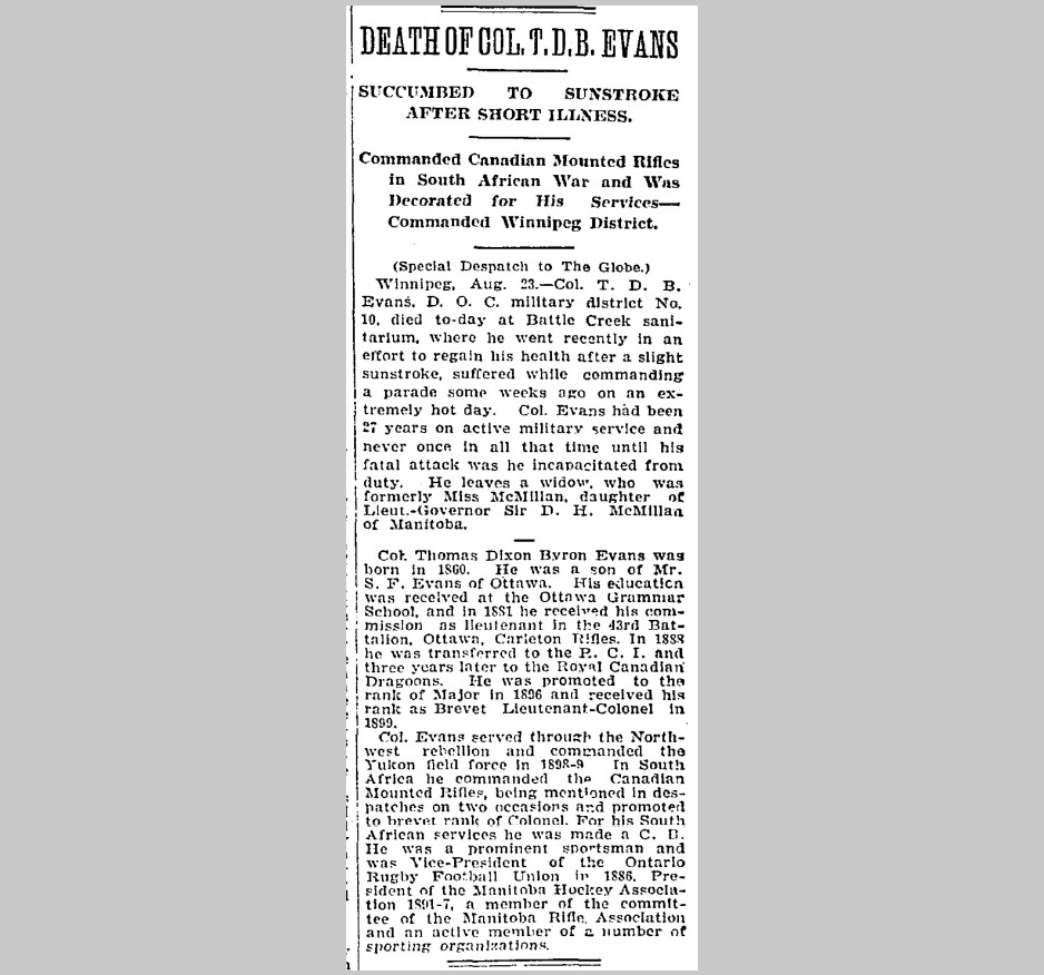
DEATH OF COL. T.D.B. EVANS: SUCCUMBED TO SUNSTROKE AFTER SHORT ILLNESS, Commanded Canadian Mounted Rifles in South African War and Was Decorated for His Services—Commanded Winnipeg District, The Globe (1844–1936), Toronto, Ontario, August 24, 1908: 1 (OCLC 1775438)

These details allowed me to identify further relevant primary and secondary sources, including orders-in-council held at LAC that track changes throughout Colonel Evans’ military career and photographs from his time in Manitoba.

A black-and-white photograph of five men at a table covered with a white table cloth. A plant appears to be the table’s centerpiece, and various bottles, plates and dishes can be seen on the table.

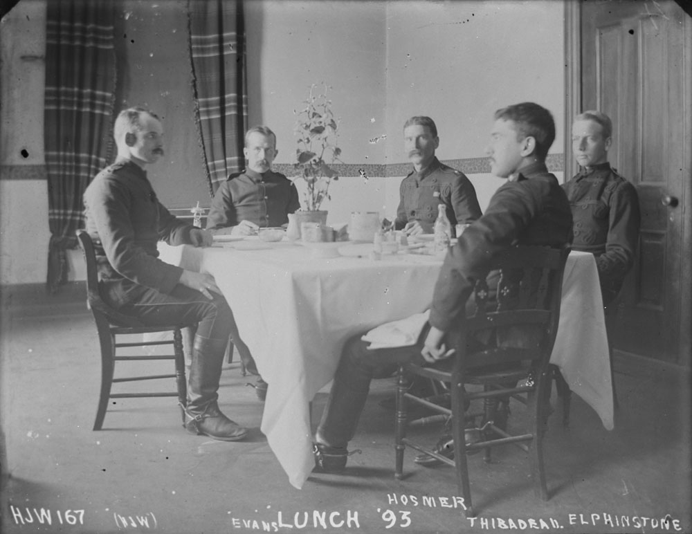
Lunch ’93. Left to right: H.J. Woodside, Captain T.D.B. Evans, Hosmer, Thibodeau, Elphinstone, 1893. Accession 1967-025, item 167. Credit: Henry Joseph Woodside/Library and Archives Canada/PA-016013

This is the query that really drove home for me the importance of combining archival and published sources held at LAC and of relying on trusted external secondary sources to conduct my work thoroughly and diligently. In hindsight, I can think of many other sources on which I could have drawn, such as census documents (which likely would have included an overwhelming number of individuals named “Evans”), the Canada Gazette, and militia lists. I was lucky in this case to find what I was looking for with relative ease—or so it often seems when recounting one’s search after the fact.


Rebecca Murray is a Senior Reference Archivist in the Reference Services Division at Library and Archives Canada.

The 1931 Census: a reading list

Banner for The 1931 Census series.

In preparation for the release of the 1931 Census returns, some of us at Library and Archives Canada have done a lot of reading. We thought we’d share a few census publications that piqued our interest.

Instructions to Commissioners and Enumerators, Seventh Census of Canada, 1931, and Instructions to Enumerators, Census of the Northwest Territories [and certain other northern areas], 1931

Ready to read cursive handwriting? Although these instructions don’t help us decipher cursive (alas!), they do help us understand some abbreviations used in the census returns. Enumerators were instructed to use certain abbreviations, such as “(ab)” for “absent.” The instructions also detail what enumerators were told to record and how; for instance, who was to be considered part of the family for the purpose of enumeration. Sara Chatfield’s recent blog, “How to conduct a census – in 1931,” highlights elements new to the instructions in 1931.

Note that the Dominion Bureau of Statistics issued separate Instructions to Enumerators for the 1931 Census of the Northwest Territories, certain parts of Yukon, eastern shore of Hudson Bay north of Great Whale River, and southern shore of Hudson Strait and Ungava Bay. This separate set of instructions was issued because the census of population in these areas was recorded using a separate form (Form I-N.W.T.), and also because the census in these northern areas was taken earlier—at any convenient time between October 1, 1930, and June 1, 1931, rather than as of June 1, 1931—for logistical reasons.

A printed page with titles and a crest.

Screenshot of cover page of Instructions to Enumerators, Census of the Northwest Territories [and certain other northern areas], 1931 (Library and Archives Canada/CS98-1931I-1-eng, title page)

The Administrative Report on the Seventh Census of Canada (Seventh Census of Canada, 1931, Volume I, Summary)

The Administrative Report on the Seventh Census of Canada provides good reading for those of us who are curious about what the Dominion Bureau of Statistics did with the handwritten census returns after they arrived in Ottawa from across the country.

The “New Census Machines—Sorter-Tabulator and Verifier” section (pages 58–62) provides insight into how the information in the handwritten census returns was processed at the Dominion Bureau of Statistics. This section explains what the Bureau did with the census returns that we preserve at Library and Archives Canada. For the purposes of sorting and tabulating results, Bureau employees punched a general card for each individual listed in the census returns, meaning that the Bureau must have punched over 10 million general cards. Can you decipher the information recorded on the following general card? For an answer, see page 59 of the report.

A rectangular card with 20 irregular divisions, each featuring numbers or letters, some of which are punched, and numbers 1 through 24 along the bottom of the card.

A general card used by the Dominion Bureau of Statistics for sorting and tabulating activities during the 1931 Census (OCLC 796971519)

A second type of card, the family and occupation card, “was used for the purpose of compiling statistics relating to the Canadian home and family” (page 59).

A rectangular, 80-column Hollerith Card (punch card), featuring column headers such as household, private family, personal, occupations and earnings, and unemployment.

A family and occupation card used by the Dominion Bureau of Statistics for sorting and tabulating activities during the 1931 Census (OCLC 796971519)

Sorting, counting and recording proceeded mechanically. The Dominion Bureau of Statistics had developed, in-house, a new sorter-tabulator for the 1931 Census, increasing possibilities for cross-analysis “several thousands of times” (page 60). The Administrative Report describes how this new sorter-tabulator worked and features a photograph—admittedly grainy—of the machine as well as of others, such as the verifier and the gang-puncher, on pages 72–73.

A black-and-white photograph of a large, high-ceilinged room in which approximately 80 employees (mostly women) sit at machines, punching in information recorded on a large roll in front of each machine. The employees sit in six columns, each of about a dozen rows, facing the photographer. The rows of employees are so numerous that they seem to extend into the distance. In the foreground, drawers of cards are lined up carefully on desks. In the middle ground, a woman stands observing a woman sitting at a punching machine. At the far right and in the background, additional personnel (mostly men) sit at additional rows of desks or are walking about.

Employees working on the 1931 Census in the punching room at the Dominion Bureau of Statistics (from Statistics Canada’s 2018 online HTML version of Standing on the shoulders of giants—History of Statistics Canada: 1970 to 2008, by Margaret Morris)

Another section in the Administrative Report, “The Field Work” (pages 51–56), describes the task of enumerating each person within the borders of Canada at that time. Additionally, in this section, the Bureau reports not only the number of enumerators involved but also the enumerators’ regular occupations. Among the 13,886 people working temporarily as enumerators, their regular occupations were most frequently the following:

A screenshot of text from a printed document.

A listing of the “most numerously represented occupations” of 1931 Census enumerators, from the Administrative Report on the Seventh Census of Canada (OCLC 796971519)

The Administrative Report was republished as Part I of the Dominion Bureau of Statistics report on the Seventh Census of Canada, 1931, Volume I, Summary (Ottawa, King’s Printer: 1936).

“Radio sets in Canada, 1931”

New for the census of population in 1931 was a question about radio sets. The Dominion Bureau of Statistics 1932 bulletin “Radio sets in Canada, 1931” provided a preliminary count of the result. The bulletin tabulated radio sets by province, census division and urban centre of more than 5,000. People in Montréal—listed as the biggest urban centre, with a population of 818,577—owned a total of 70,164 radio sets. However, Toronto—listed as the second-biggest urban centre, with a population of 631,207—reported the highest total of radio sets owned: 91,656.

A photograph of a man in a cardigan with a pipe in his mouth sitting at a typewriter; his surroundings include a bookshelf, a lantern and a radio.

A radio features in the background of this January 1931 photograph of Richard Finnie typing notes in Kugluktuk, Nunavut (a100695)

Not all of our reading was pleasant. Reading through publications from the 1930s is a reminder of the varied ways in which racism, sexism and colonialism were manifest at that time. Those attitudes shaped the taking of the census and have had enduring legacies into the present.

We’ve mentioned just a few examples of what we’ve been reading from among the many publications that preceded or resulted from the 1931 Census of Population. Generally speaking, the Dominion Bureau of Statistics released preliminary counts and summaries as soon as possible after the 1931 Census, as it did with “Radio sets in Canada, 1931.” The Bureau subsequently published definitive findings and analyses in the multi-volume official report of the 1931 Census. Statistics were published in volumes I through XI during the years 1933 to 1936, and additional thematic analyses on topics such as “housing in Canada” and the “lengthened dependency of youth” were published as volumes XII and XIII in 1942. These publications and many more are found in the library collections at Library and Archives Canada. Many such publications have been digitized by Statistics Canada and made available on the Internet Archive and the Government of Canada Publications catalogue.

If you’re interested, we invite you to browse some of the published heritage from the 1931 Census of Canada. And good luck interpreting cursive handwriting in the census returns!

Don’t take it for granite: Geological Survey of Canada photographs

By Martha Sellens

Several years ago, I was contacted by a researcher who was looking for the first photograph taken on a Geological Survey of Canada (GSC) survey expedition. They knew that the photograph was held by Library and Archives Canada (LAC), but they were having trouble finding it. At the time, I knew only a little about the GSC records that LAC holds. When I started looking into the GSC photograph collection, I immediately understood why the researcher was having difficulties. There was a lot of information about the collection, but not all of it was available to the public on our website, and what was available was difficult to navigate.

With a bit of digging and a few false starts, I was able to find the first photograph and a few others that the researcher was looking for. Together, we examined the glass plate negatives and fragile photograph albums at LAC’s Preservation Centre in Gatineau (fragile materials like these don’t travel from the storage site).

I was hooked. The GSC photograph collection has a huge variety of photographs taken across Canada as part of survey expeditions in the 19th and early 20th centuries. Yes, there are many photographs of rocks, as is only fitting for geologists, but there are also photographs of landscape views, Indigenous peoples, wildlife, European settlements, Chinese immigrants and the Canadian Pacific Railway, as well as other subjects.

The first GSC photograph was taken in 1860 by James Richardson on his expedition along the north shore of the Gulf of the St. Lawrence to the Strait of Belle Isle. It shows one of the expedition members sitting on a ridge of rock. The GSC photograph collection is numbered sequentially, and the photographs that Richardson and his assistant, Mr. Reeves, took on this expedition have GSC negative numbers between 1 and 28. At LAC, we have some of the original glass plate negatives as well as prints of the photographs.

A black-and-white photograph of a man sitting on a ridge of rock.

GSC Negative 1, James Richardson, 1860, taken on his expedition to Quebec and Labrador (a038063)

After finding those photographs and learning more about the GSC photograph collection, I was determined to improve their description so that more people could make use of them. But how? The majority of these photographs were transferred to the archives in the 1970s, long before our current computer systems and databases were in use. Many of my predecessors have worked to improve the description of the collection over the years, and it was frustrating to see that their efforts could no longer be accessed or understood by the public for technical reasons.

A black-and-white photograph of a train engine that has fallen on its side in a river. Workers are visible on raised train tracks. The background includes trees and mountains.

Grand Trunk Pacific Engine No. 6 derailed at Fiddle Creek, Alberta, D.B. Dowling, 1911, GSC negative number 18883 (a045437)

My first step was to review the existing information that we had about the collection. The GSC photograph collection includes nearly 30,000 photographs. The existing finding aid provided online was a 150-page PDF that compiled a report, a box list, and a number of original captions in one giant document. In the late 1990s, LAC staff also created a dedicated database to make it easier to find individual prints and negatives. However, that database was never available online. Another issue was that it had to be migrated into a new software format in 2016, and some of the functionality was lost.

A black-and-white photograph of eight surveyors sitting to the left of a campfire.

Camp fire group, D.B. Dowling, 1911, GSC negative number 18916 (a045420)

Analyzing and comparing all of this data became one of my work-from-home pandemic projects. Given the scale of the collection, I wasn’t able to do this work on an item-by-item level. Instead, I focused on two aspects of the collection: the photograph albums and the finding aids.

When I started, only two of the 78 photograph albums were described in our database. Now, each photograph album is described in LAC’s online database with information about the photographer, the geographic locations, the dates, the relevant GSC expedition, and the negative numbers assigned to the photographs by the GSC. I was also able to sort many descriptions of individual photographs into the albums where they are found.

A black-and-white photograph of a square-rigged sailing ship with three masts surrounded by ice. A person stands on the ice to the left of the stern.

S.S. “Diana” with rudder crushed in ice off Big Island, Hudson Strait, A.P. Low, 1897, GSC negative number 2198 (a038232)

When it was available, I also included information about the GSC survey expedition depicted in each album, and I provided a reference to the original field notebooks also in the collection at LAC (see R214-65-1-E). James Richardson’s field notes (Québec – Manitou River and Île des Esquimaux regions and locations on Newfoundland) even discuss when he or his assistant took photographs!

I also created new finding aids by consolidating information from three or four different sources, so that researchers and archivists didn’t have to check multiple locations to learn everything. Through this process, I was also able to identify inconsistencies and errors, to ensure that the information was as up to date as possible.

A black-and-white photograph of a landscape view. A calm river runs through the middle of the photograph with trees on either side. A person is visible on the rocky shore in the middle distance.

Brokenhead River, Manitoba, at lowest rapids, J.B. Tyrrell, September 29, 1891 (a051459)

Now, if you’re looking for a photograph in the GSC collection, you can check one of several new finding aids that I created to find negatives (Finding Aid 45-36 Geological Survey of Canada Negatives), albums (Finding Aid 45-36 Geological Survey of Canada Albums) or prints (Finding Aid 45-36 Geological Survey of Canada Prints). The listings are not complete, but they provide information about nearly half of the photographs in the collection, and the updated format is easier to read and search. Most of the photographs in this collection are identified using a GSC negative number, like James Richardson’s GSC Negative 1. Sometimes we have both the original negative as well as one or more prints of the same image. For others, only the negative or a print have survived.

A black-and-white photograph of sled dogs in harnesses and people in parkas. There are snow-covered trees in the background.

Dogs resting near Split Lake, Northwest Territories, J.M. Macoun, 1910, GSC negative number 14917 (a045274)

LAC also has many of the original catalogue cards that the GSC used to organize negatives in their photograph library. The cards often include the GSC negative number, photographer, date, location, and caption. Sometimes the cards will also mention if the negatives were damaged or broken. Portions of the cards are organized by location, subject, or negative number, so they can be used in different ways to find specific photographs. However, since the cards were created by the GSC, they don’t have LAC container information listed on them. These cards need to be used with the other finding aids to locate each item. But they are also useful for contextual information that we haven’t yet been able to add to LAC’s database. If you have found an interesting photograph, and want to know more, you can check the catalogue cards to see if they have any further information there.

My work on improving the GSC collection is far from over, but I hope that the new finding aids and descriptions will help more people to explore this fascinating collection.

Additional resources

  • Geological Survey of Canada Photographs (R214-419-X-E)
  • Photograph album: Quebec and Labrador 1860, James Richardson (R214-2999-9-E)

Martha Sellens is an archivist in the Government Archives Division at Library and Archives Canada.

How to conduct a census – in 1931

By Sara Chatfield

This article contains historical language and content that some may consider offensive, such as language used to refer to racial, ethnic and cultural groups. Please see our historical language advisory for more information.

I have a confession to make: the Instructions to Commissioners and Enumerators is my favourite part of a census. My enthusiasm for these directions was documented in my previous blog post about the instructions for the 1926 Census. When I learned that the 1931 Census was going to be released, my first thought was, “What new questions did they ask that year?” Luckily, there is a 108-page document digitized by Statistics Canada that was full of information for me to examine.

A printed page with titles and a crest.

The cover page from the Instructions to Commissioners and Enumerators (OCLC 1007621746)

The document has a cover page declaring that it is the Instructions to Commissioners and Enumerators for the Seventh Census of Canada, 1931 by the Dominion Bureau of Statistics.

The first section of the document, titled “General Provisions,” is administrative in nature. In this section, you can learn more about the employment side of enumerating the 1931 Census. There is information about the date on which the census enumeration began, the daily earnings of the commissioners, the enumerators’ rights, and how to handle refusals to answer. In the case of refusals to answer, the enumerator was cautioned that “… it is of the utmost importance that his manner should, under all circumstances, be courteous and conciliatory. In no instance should he lose his temper or indulge in disputation or threats. Much can be accomplished by tact and persuasion. Many persons will give information after a night’s reflection which they refused to give when first visited.”

There is also an entry in the General section stating: “No employee can farm out his work. It is not permitted to a commissioner, enumerator or other employee of the Census to engage a substitute or to farm out his work to another.”

A screenshot of text from a printed document.

A portion from the Instructions to Commissioners and Enumerators stating that “No employee can farm out his work.” (OCLC 1007621746)

Beyond learning more about the job conditions of the enumerators (the individuals who collected information for the census) or the commissioners (the individuals who trained and supervised the enumerators, and checked their work), the General section is worth reading because it gives vital information like “Indian Reserves shall not form part of any enumeration area; their enumeration will be made by officials of the Indian Department.” It is very important to know this if you are researching Indigenous communities or ancestors.

The next section of the document is titled “Instructions Relating to the Population Schedule.” This section will give researchers clear indications about who was enumerated as a member of the family, who was not to be enumerated as a family member, and how the enumerator noted the information given by the respondent. This is helpful if your family of interest includes a student, a visitor, a domestic servant or a labourer, a sailor or fisher away at sea, or a member of a railroad or construction camp. The Population section also gives the enumerator clear instructions on how to populate each of the columns, for example, column 7 (class of house) and column 8 (materials of construction).

A screenshot of text from a printed document.

A portion of the instructions listing how houses and construction materials should be noted in the census (OCLC 1007621746)

Compared with the instructions to the enumerator for the 1921 Census, it appears that more information was provided in 1931 about who should be enumerated as family members. The 1931 instructions to the enumerator give more options and more detailed descriptions. As well, a new column was added in 1931 to determine how many families had a radio. This was the dawn of telecommunications! We can speculate that respondents were asked whether they had a radio in the home as a measure of how quickly and broadly information could be disseminated. The 1931 Census is a way to track this then-new form of pop culture on the rise!

A screenshot of text from a printed document.

The 1931 Census asked how many Canadian families had a radio (OCLC 1007621746)

Another part of the 1931 instructions that was expanded was about people who were born outside Canada. The 1921 instructions were that “if a person says he was born in Austria-Hungary, Germany, Russia, or Turkey, as they were before the war, enter the name of the Province (State or Region) in which born, as Alsace-Lorraine, Bohemia, Bavaria, German or Russian Poland, Croatia, Galicia, Finland, Slovakland, etc.; or the name of the city or town in which born, as Berlin, Prague, Vienna, etc.” The 1931 instructions include border changes and new geopolitical realities, now that the world was more than 10 years from the end of the First World War.

A screenshot of text from a printed document.

Detailed instructions on how to enter the place of birth if the person was born outside Canada (OCLC 1007621746)

These are just a few of the instructions from the document that stood out for me. We would love to hear which parts of the instructions you found the most interesting or helpful!


Sara Chatfield is a project manager in the Access and Services Branch at Library and Archives Canada.

Improving your online experience: Analytics, feedback, improvements, user experience and changes to come on our new website

Image of fingers on a keyboardBy Andrea Eidinger

In my last blog post, I talked about how important user experience (UX) feedback was to the development and improvement of Library and Archives Canada’s (LAC) new website design. I also mentioned that we would be taking an iterative approach, continuing to evolve in response to the feedback received. Now that it’s been nearly a year since the launch, this is a great time to give you a little behind-the-scenes look about how we handle analytics and feedback, and share some details on the changes (big and small) that we’ve made and are looking to make on the website.

Analytics

Web analytics, such as the number of visits and visitors, and the average time on the site, are all helpful measures when it comes to determining the success of a website. They can tell us which pages are used most frequently and give us a sense of what our users are searching for on the site. Some more advanced features, like flows, can even show us how people navigate our website. Here is one example of a healthy flow for our “Help with your research” page, captured in January 2023.

A graphic representation of how individuals navigate our website, specifically how they arrive at and then leave a particular help page.

A look at how individuals navigate to and from the “Help with your research” page

The centre column is the page under analysis, in this case “Help with your research.” On the left is where people were before arriving at “Help with your research,” and on the right is where they went after leaving that page. For example, the top lines show people navigating from the home page to “Help with your research” to “Genealogy and family history.” This is exactly what we want to see: individuals going to their specific subject of interest. And we are also pleased that only a small number, the tiny bit of red at the bottom right in the centre, are leaving the site altogether from the help page.

Feedback

In addition to analytics, we collect users’ online experience feedback using different channels. If you’ve ever scrolled all the way down to the bottom of our web pages, you may have noticed a little box that looks like this.

A screenshot of the feedback collection tool, which asks users to answer the question “Did you find what you were looking for?” and provides them with the option to answer yes or no.

The feedback collection tool (Library and Archives Canada)

This box is called a feedback collection tool. It provides an easy, anonymous way for our users to provide us with comments about their experiences, both positive and negative. We also get a lot of feedback through our email (servicesweb-webservices@bac-lac.gc.ca), as well as through other teams like Reference Services. Our top task survey, which is the little pop-up that some of you see when you log onto the site, is another tool that is available for users to provide comments.

All of this feedback is gathered together in a single location and then analyzed. We read every single comment that you send, and we look for common problems that people encounter.

Small changes, big results

As fascinating as this information is in its own right, we are using it to make improvements across the site. Our iterative approach means we make small changes on a regular basis in response to feedback. For example, when the website was launched in August 2022, we noticed that a lot of people were using the Collection Search bar on the home page to access some of our stand-alone databases. This means that it was unclear to users what they could search and access from the Collection Search bar. This is what it originally looked like.

A screenshot of a previous version of the LAC home page, showing several entry points into the website as well as a plain text box option to search in Collection Search.

An earlier version of our home page, featuring the original Collection Search bar

To help users with their searches and navigate our website, we worked to make it more obvious what the search bar was for, how to use it and how to find other helpful resources. Here are some of the options that we considered.

Four different options for the design of the text search box, differentiated by colours, text inside the box and accompanying text.

Four different options for a new Collection Search bar

Ultimately, we combined several different features and arrived at this version.

A screenshot of the final version of the text search box, which is surrounded by a pale grey box, with the words “Search government records, letters, diaries, images and more” and links to help pages on our search engines and other tools.

The final version of the Collection Search bar (Library and Archives Canada)

And it worked! Since then, the number of searches for databases through Collection Search bar dropped down to zero. Success!

UX Research and Design

Another tool in our toolbox is UX research and design. A few months ago, one of our UX designers, Alexandra Haggert, explained how UX design works. Here is another example of how using metrics and feedback, coupled with UX research and design, can improve our website for a better user experience.

When we launched Census Search beta in November 2022, feedback from users pointed out two common problem areas. Firstly, when searching, users would like to have the ability to search several specific provinces, rather than all or one at a time. Secondly, when searching in genealogy, often the “Year of birth” or “Year of immigration” might be an estimate. Here is what the page looked like before.

A screenshot of the first version of Census Search, with options to search by census year, name, years of birth or immigration, place, or location in the archive.

The original version of Census Search

To better help users in their searches, we came up with the solution of adding two features. The first was the ability to select one or more provinces by check box. The second was the ability to a range for the year of birth or immigration allowing to search up to 10 years before and after the date identified.

A screenshot of the final version of Census Search, with red arrows pointing out the options to add ranges for Year of birth and Year of immigration.

The final version of Census Search (Library and Archives Canada)

This made it much easier for our users to find specific individuals using Census Search.

If you want to provide feedback on Census Search, you can email recherchecollectionsqr-collectionsearchqa@bac-lac.gc.ca.

What are we working on now?

Some of the most common comments that we are getting are related to the following:

  1. What is or isn’t available at LAC, especially in terms of modern records
  2. How to access obituaries on the LAC website
  3. How to find some of our smaller databases (like Second World War Service Files – War Dead, 1939 to 1947)

We are still working on the best solutions to these issues, so stay tuned.

And this is just the beginning! Analytics, feedback, and UX research and design will continue to be essential tools when it comes to website design. They help us to know what you want and need so that we can improve your online experience. So please keep the feedback coming! Reach out to us at servicesweb-webservices@bac-lac.gc.ca.


Andrea Eidinger is an acting Manager in Web, part of the Access and Services Branch at Library and Archives Canada.

Why are the 1931 census returns organized geographically?

At Library and Archives Canada (LAC), we receive questions about why materials in our collections are organized the way they are.

When it comes to the census returns, typically we explain that, as an archive, we acquire the census returns as they are—even when the writing is blurry or unreadable—as historical records. We also strive to maintain the records’ original order and context.

For the 1931 census returns, maintaining the records’ original order is not difficult. Rather than receiving 234,678 pieces of paper, we received 187 microfilm reels. On the microfilm, the imaged census returns are organized, overall, by province (east-to-west) and then by northern area (west-to-east). This is because the Dominion Bureau of Statistics imaged the census returns in order of census district number, and, within each census district, in order of census sub-district number. When we digitized the archival records here at LAC, we worked to ensure that the digital access copies would reflect the archival records’ original order and context to the extent possible. For instance, we grouped digitized images according to the title cards used in the microfilmed images. To each group of digitized images, we added additional metadata, extracted from the Dominion Bureau of Statistics’ listings accompanying the census returns.

A handwritten index card.

Example of a title card used to organize 1931 census returns on microfilm. This title card is for the eight pages of returns from Prince Edward Island, census district 3 (Queens), sub-district 10 (MIKAN 5744023)

But this explanation does not answer the original question: why are the returns from the 1931 census of population organized geographically—by census district and sub-district—in the first place?

For answers to this original question, we turn to the Administrative Report included in the Dominion Bureau of Statistics’ 1936 publication Seventh Census of Canada, 1931, Volume 1, Summary.

Answer 1: Because of the original purpose of the census of Canada. The census returns are organized geographically because of the decennial census’ role in shaping representation in the House of Commons.

“In Canada the immediate, legal raison d’être of the census is to determine representation in the […] House of Commons. Under the [Constitution], the province of Quebec is given a fixed number of seats[…] while the number assigned to the other provinces is pro rata on a population basis as determined by the census[….] The Canadian Census is thus taken primarily to enable a redistribution bill to be passed through Parliament” [Page 32; emphasis added]

It is worth getting a bit technical here. In the early part of the 20th century, redistribution bills updated the number and boundaries of federal electoral districts based on changes in population—as established by the previous decennial census—among other considerations established by law.

A map depicting federal electoral districts in the prairie provinces—the boundaries are indicated by thick blue lines, and the names are indicated in blue type. The map was prepared on a base map featuring rivers and lakes, railways, cities and grid lines.

“Map of Federal electoral districts of Manitoba, Saskatchewan & Alberta” from an atlas created in 1924, prepared by the Department of the Interior (e011315903)

The updated boundaries of federal electoral districts informed the census districts used for enumeration purpose in the subsequent decennial census. In other words, the relationship between federal electoral district and census district had elements of a chicken-and-egg scenario.

Egg: Federal electoral district boundaries, as established in the Representation Act of 1924.

The Representation Act of 1924, sometimes referred to as the Redistribution Act, established the electoral districts to be used in subsequent federal elections. This redistribution of electoral districts was based, in part, on the population count and distribution established by the previous decennial census, namely, the Sixth Census of Canada in 1921.

The Representation Act established the official boundaries of federal electoral districts in form, not in maps.

  • To view transcriptions of these descriptions of electoral districts, consult the Library of Parliament’s online resource “Elections and Candidates” for the 17th parliament; the description of each electoral district can be viewed by clicking on a constituency title listed for the general election of July 28, 1930, and then scrolling below the header “Information” to the description under the subheader “S.C. 1924, c.63,” which refers to the Representation Act.
  • Although the Representation Act did not include maps, the Department of the Interior prepared an atlas with maps depicting the updated federal electoral district boundaries. To view digitized images of the maps in the 12-volume atlas, there are two options. The catalogue record for the Federal electoral district maps, 1924 displays thumbnail images. A 1931 Census Maps research tool supplies links to individual, higher-resolution maps.

Chicken: Census districts used for 1931 census.

1931 census districts used in enumeration mostly corresponded to the federal electoral districts established in the Representation Act of 1924, because

“[f]or the purposes of the census, the Statistics Act requires that the country be first divided into “census districts” corresponding as nearly as possible with the federal electoral divisions or constituencies for the time being—this in view of the association of the census with parliamentary representation.” [Page 51]

Nevertheless, at least eight electoral districts were “too large or too varied in physical or economic character” for the purposes of census work, and so each was split into two or three census districts (in Quebec, Charlevoix–Saguenay, Gaspé, Labelle and Pontiac; in Ontario, Port Arthur–Thunder Bay; in Alberta, Peace River; and in British Columbia, Cariboo and Comox–Alberni). Other areas to be enumerated fell outside a federal electoral district (e.g., Northwest Territories, Royal Canadian Navy ships).

The population established by the Seventh Census of Canada in 1931 was then used to inform the next redistribution of federal electoral districts.

Egg: Federal electoral districts, as established in The Representation Act, 1933

This chicken-and-egg scenario is why, at LAC, we often use federal electoral district maps as working stand-ins for census district maps to help us navigate the census returns from the early part of the 20th century. To navigate the 1931 census returns, we use maps depicting the federal electoral districts as established in the Representation Act of 1924. In the year 2028, we will likely be using the maps depicting federal electoral districts according to The Representation Act of 1933 to help us navigate the 1936 census returns from the prairie provinces after those census returns are transferred to LAC.

Answer 2: Logistics was another reason why the census returns were organized geographically.

The 1931 Census of Canada, like most population censuses, was meant to enumerate each person within the boundaries of the Dominion of Canada once, and only once. For this purpose, land within the borders of Canada, and navy ships, were divided into 15,167 units of enumeration. Each geographical unit of enumeration—called a census sub-district—was assigned to a single enumerator (more or less), tasked with recording each person residing within the census sub-district.

Four people interacting in a sub-zero-degree landscape.

Enumeration proceeding in 1961: An R.C.M.P. member talks to three people from an Inuit community to collect census information (e011177562)

“The census enumerator is the only census official coming into direct contact with the general public; [s/he] is who makes the house-to-house and farm-to-farm canvass and who is primarily responsible for the details collected on the census schedules. The necessity of providing that no more or no less than a suitable amount of work should be assigned to each enumerator (experience has demonstrated this to be a population of 600–800 in ordinary rural districts, and of 1,200–1,800 in urban) […] renders departure necessary in many cases from the electoral boundaries; […] and the polling subdivisions are not always convenient as census sub-districts. In all such cases, however, the division is effected in a way that permits compilation of the results in the form required for the purposes had in mind by the Act.” [Page 51]

Establishing the geographical boundaries to be used in the census was no minor feat:

“The drawing up of the scheme of census districts and sub-districts is a task of considerable magnitude; it is put in hand about two years in advance of the census date, and is carried out not only in the light of conditions revealed in the preceding census, but in consultation with local officials, so that no inhabited area may be overlooked or left unprovided with the organization best suited.” [Page 51]

Ninety-two years later, the task of finding a particular census return among the 1931 census returns that are organized geographically—organized according to census district and sub-district—may seem a little overwhelming. The blog posts Puzzling through 1931 Census sub-districts – Part 1 and Part 2 describes the approaches we use at LAC to navigate the 15,167 sub-districts used for enumeration in the 1931 census.

Vimy Memorial visit: fact or fiction? (the sequel)

By Rebecca Murray

Conversation between the author and her father via text message. She texts: “Dad, I didn’t find anything about great-grandpa Phillips and the Skeena at Vimy.” Dad replies: “Oh whoops, it was the Saguenay.” She responds: *silence*.

Text messages between the author and her father. Image courtesy of the author, Rebecca Murray.

Has this ever happened to you? You started your primary research with abandon and came up empty, only to discover that the facts you were using were incorrect. This can be extremely frustrating. You might feel like you have wasted your time and energy. And yet, this happens more often than you might think, even to seasoned researchers.

Happily, history is not going anywhere, so we can take a second kick at the proverbial can. Come along and see what we find this time!

Do you remember my previous blog about trying to trace my great-grandfather’s attendance at the unveiling of the Vimy Memorial in July 1936?

We knew that Thomas Caleb Phillips went to France alongside a Canadian naval band. We thought it was the band associated with the HMCS Skeena, but in fact, it was the HMCS Saguenay.

What a difference this one word, this one piece of information, makes in the search!

To confirm, with archival records, that the HMCS Saguenay was even in the vicinity of Arras, France, in the summer of 1936, I consulted RG24 volume 7812 file “Ship’s log – SAGUENAY – Old,” 1935/07 – 1937/09.

Look at what I found in the log for July 1936: the first image shows that a group from the ship visited the memorial the day before the unveiling.


A handwritten logbook for the HMCS SAGUENAY, dated July 25, 1936. The excerpts read: “Royal Guard entrained for Vimy” and “Port Watch proceeded on Excursion to Vimy.”

Ship’s log, HMCS SAGUENAY, July 25, 1936 (MIKAN 1084556). Image courtesy of the author, Rebecca Murray.

The next day’s information is even better, providing further details about the memorial from the perspective of the crew’s movements.

A handwritten logbook for the HMCS SAGUENAY, dated July 26, 1936. The excerpt reads: “Starboard watch proceeded on excursion to Vimy. – Piped Down.”

Ship’s log, HMCS SAGUENAY, July 26, 1936 (MIKAN 1084556). Image courtesy of the author, Rebecca Murray.

For me, reading these entries was one of those exciting moments where you are in a very quiet room surrounded by other researchers and staff doing important work, and you just want to jump up and down and squeal with delight at what you have found! Then I turned the page, because you never know what is waiting around the corner, and lo and behold, what did I find? A truly unexpected mention of my great-grandfather, the very man I was looking for, in the handwritten logbook.

A handwritten logbook for the HMCS SAGUENAY, dated July 29, 1936. The excerpt reads: “Engineer Commander T.C. Phillips disembarked.”

Ship’s log, HMCS SAGUENAY, July 29, 1936 (MIKAN 1084556). Image courtesy of the author, Rebecca Murray.

Now it is July 29, and the ship is at Dover in England, and look who went ashore for a visit!

This is the link I had been searching for! (Exaggerated fist pump.) Let us just hit pause for a moment and make an observation: I previously wrote about how research with archival records, especially government records, can be very time consuming and take a lot of patience. I did not expect to find any mention of T.C. Phillips in the ship’s log. I was simply trying to confirm that the HMCS Saguenay had been near Vimy Ridge (or as close as a ship can get to rural northern France). This “find” was almost enough to convince me to stop searching for further records—almost.

Something else that I was happily reminded of by the experience of sharing my research on the previous blog is that when you share a problem, it can be halved. One of the benefits of working with naturally curious colleagues is that they will offer their suggestions about how you might find the answer you are looking for. For example, one colleague suggested checking specific sailing lists related to the Vimy Pilgrimage.

And in sharing the story of my research with extended family, I not only gathered corrected secondary information (ahem!), but also an item that I will be filing away for my own archives: a worn postcard that T.C. Phillips sent to his wife, my great-grandmother, in Ottawa, dated July 27, 1936. Although the message itself tells us little about the role he was fulfilling by being at the unveiling of the memorial, the card itself is full of information that could send any researcher, let alone the writer’s great-granddaughter, down any number of rabbit holes. For example, the stamp affixed to the postcard appears to be an image of the sculpted figures, The Defenders, shown on the card itself.

A sepia-tone image on the front of a postcard showing some stone figures of the Vimy Memorial.

Postcard sent by T.C. Phillips on July 27, 1936, from France to Ottawa. Image courtesy of the author, Rebecca Murray.

A green-hued stamp depicting a stone sculpture from the Vimy Memorial. The stamp has been cancelled, and a partial postmark is visible to the left of the image.

Part of the postcard with the cancelled stamp. Image courtesy of the author, Rebecca Murray.

Another research path that I could explore is the journey that T.C. Phillips took to get to France. A bit more research in the family album tells me that he travelled to France on the SS Alaunia, a ship that served mainly on Cunard’s Canadian service. I found historic passenger lists confirming that the ship departed from Montréal on July 20, 1936, and arrived in London, England, but T.C. Phillips’s name is not among those who “landed” there. For today, though, this is far enough, and that too is a valuable lesson to learn and incorporate into our research. There is always one more lead to follow up on, one more potentially relevant fonds or publication to check, but, as I mentioned in the previous post, where is the fun in being done? So I will hold on to this particular mystery until my next foray into this story.

Family lore can be subjective, so it can be challenging to match it with primary source records. As such, it requires a delicate approach, whether you are working with your own family or helping someone else, as we so often find ourselves doing in Reference Services. I cannot emphasize enough the importance of good secondary research and preparation before a visit to an archive for primary source research.


Rebecca Murray is a Senior Reference Archivist in the Reference Services Division at Library and Archives Canada.

Improving your online experience: Launch of the new Government of Canada Web Archive

Image of fingers on a keyboard

By Tom J. Smyth

Introduction and program history

Library and Archives Canada (LAC) is the nation’s designated national memory institution, with a legislated mandate to acquire, describe, preserve and provide long-term access to Canada’s documentary heritage.

This includes the Canadian Web! Resources in formats for the Web are recognized internationally as an important facet of a nation’s modern digital heritage. These irreplaceable web resources are important evidence of Canadian history and culture in the 21st century, but they are volatile and prone to disappearing without warning.

What can be done about this? How do we “rescue” resources generated in real time, which exist outside the normal production streams of archival records or traditional publications? How do we safeguard web resources that can therefore contain information found in no other medium, which may document national historic events or important aspects of culture as they are unfolding?

Owing to their precarious nature, immediate and managed action is required to select, arrange, make available and ensure the digital preservation and data continuity of web resources that constitute Canadian digital documentary heritage. This action is referred to internationally as “web archiving,” which is a discipline based on digital preservation and curation that is practiced and advanced by, for example, the 50-plus members of the International Internet Preservation Consortium (of which LAC is a founding member).

Acquiring web resources became a formal part of LAC’s mandate in 2004 under the Library and Archives of Canada Act, subsection 8(2). LAC’s means of realizing this part of its mandate is the Web and Social Media Preservation Program within the Digital Services Sector. The program curates data and researches collections of unique web resources documenting Canadian historical and cultural themes and events, in alignment with the requirements of modern digital scholars. It also makes these resources available to the public for posterity and to support future international research on Canada.

The web resources acquired by the program are made available through the Government of Canada Web Archive (GCWA). While the program and the GCWA are well known in Canada, their scale may not be.

How big is the GCWA? How much data does the GCWA contain?

In 2022–23, the Web and Social Media Preservation Program at LAC reached an important milestone.

As of February 2023, we are pleased that the GCWA exceeded 120+ terabytes of total data and surpassed over 3.1 billion assets or documents.

This is about the same amount of data as 4,600 Blu-ray movie discs (1,150 in 4K, or 384 copies of your favourite movie trilogies in 4K). If the GCWA were printed out on paper, it would take up some 57.5 billion sheets; stacking this up, it would reach the same height as 12,263 CN Towers!

Some program clients may be surprised to hear this, because since 2005, LAC has only provided public access to portions of its federal web archival collections. This means that fully 50 percent of the total collections have therefore never been available to the public until now.

Screenshot of a Government of Canada Web Archive page.

New functionalities and features of the relaunched Government of Canada Web Archive (GCWA)

New collections

We are delighted to announce that, with the relaunch of the GCWA in 2023, LAC will begin providing access to all non-federal collections curated since 2005. At the time of launch, the following collections will be available:

  • The Truth and Reconciliation Commission Collection (curated in partnership with the Centre for Truth and Reconciliation, the University of Manitoba and the University of Winnipeg)
  • The LAC collection on COVID-19 and its impacts on Canada (20+ terabytes of data)
  • All federal government data collected since 2005 (55+ terabytes of data)
  • Additional curated collections (to be arranged and published in the upcoming fiscal year)

The GCWA is one of the most comprehensive sources in existence for the following:

  • Canadian cultural and historical events as documented on the Web (2005–)
  • Official publications of the Government of Canada (GC) (2005–)
  • The federal and historical GC web presence (gc.ca domain, 2005–)
    • Historical GC financial and departmental plans and performance reports (2005–)
    • Historical GC policy frameworks (2005–)
    • Historical GC proactive disclosure (2005–)
    • Data and statistics from the federal web (2005–)
    • Material removed from the federal web under Common Look and Feel 2.0 (2005–08)
    • Material removed from the federal web under “CLF 3.0” (2008–13)
    • Material removed from the federal web under the Web Renewal Initiative (2013–)

Overall, the GCWA is the definitive source for any historical study of the Government of Canada web domain over time.

New portal design

From 2005 to 2019, the GCWA arranged data according to, and only provided access to federal government web resources under, Crown copyright (at maximum, approximately 15 terabytes of data were available). With the launch of the new GCWA in 2023, we have expanded our search tools and filters to help users explore our non-federal data and thematic web collections.

Clients will now be able to engage non-federal collections in a specialized portal and user interface. The relevant interface (government versus non-federal collections) will be presented automatically based on the collection being accessed.

Full text search of the web archive, individual collections or collection themes

Since 2011, LAC has not provided a full-text search capability or service to the public for navigating the GCWA. This situation was very problematic, and it limited client access to discovery and browsing. For the launch in 2023, a complex and powerful full-text search will be made available:

  • Clients will be able to search at multiple hierarchical levels, from the entire archive down to individual files.
  • An advanced search will also be available, including the ability to search by collection, keywords, exclusions, exact phrase, URL/domain, web resource type and date range.
  • An ability to quickly search by exact URL will also be available.
  • Further, clients will be able to discover and access the content of non-federal collections by sub-theme (for example: show all resources collected having to do with the “economic impact on Canada of COVID-19”).

Specialized reference services

LAC provides reference services and support for the GCWA. If you have difficulty locating a known resource within the GCWA, we would be pleased to assist you with the following:

  • Locating obscure Government of Canada official publications or decommissioned websites
  • Locating obscure historical reports, policies, financial data or proactive disclosure
  • Locating genres of Government of Canada content where exact titles or dates are not known
  • History and development of the Government of Canada domain (gc.ca)
  • Use of the web archives as a historical source or as computational data
  • Copyright or privacy concerns
  • Questions on how to have your web resource digitally preserved at LAC

Do you have ideas on what should be collected? Please let us know!

Ask us a question. We can help with all reference questions dealing with the web archive, nominations of Canadian web resources for acquisition, or requests for computational access to our web archival collections data.


Tom J. Smyth is the manager of the Web and Social Media Preservation Program at Library and Archives Canada.

Puzzling through 1931 Census sub-districts – Part 2

This article contains historical language and content that some may consider offensive, such as language used to refer to racial, ethnic and cultural groups. Please see our historical language advisory for more information.

This is Part 2 of the blog series Puzzling through 1931 Census sub-districts. If not done already, you may want to read Part 1, as it provides tools to help identify the census district that would have included your place of interest in 1931.

As a reminder from Part 1, to find the census returns for a place of interest, we generally need to narrow down, in order, the:

  1. province or territory;
  2. census district or federal electoral district; and
  3. census sub-district

that would have included the place of interest in 1931.

In this blog post, we go over the last step.

STEP 3. Determining the census sub-district

Each 1931 Census district was divided into multiple sub-districts – anywhere from three to 148 – for the purpose of enumeration. The majority of census districts were divided into at least 50 sub-districts.

The hitch is that no maps of 1931 Census sub-district boundaries are known to still exist. Figuring out in which census sub-district one’s place of interest was enumerated requires using one of the following tools:

  1. Street indexes (for 11 major cities)
  2. Finding aid for “Indian Reserves” (First Nations)
  3. Written descriptions of sub-district boundaries.

If your place of interest was in neither a major city nor a First Nations Reserve in 1931, skip directly to the last tool, the written descriptions of sub-district boundaries.

Tool 1: Street indexes

Indexes are available for Halifax (N.S.), Saint John (N.B.), Quebec (Que.), Montréal (Que.), Toronto (Ont.), Hamilton (Ont.), London (Ont.), Winnipeg (Man.), Edmonton (Alta.), Calgary (Alta.) and Vancouver (B.C.). Street indexes list street names and indicate in which census district and sub-district(s) those streets were enumerated.

The indexes for Hamilton and Calgary are specific to the 1931 Census. The indexes for the remaining cities cover multiple census years. In those indexes, for the purposes of locating district numbers for the 1931 Census, consider only entries beginning with “31.” The numbers that follow are the district and sub-district numbers, respectively, for 1931. So, for instance, if we are looking for a place of interest on Montréal’s Chemin de la Côte-des-Neiges in the census district of Mont-Royal (Census District no. 84), we find:

Typewritten entries for “Côte des Neiges” from the Montréal Street Index.

Excerpt from the Montréal Street Index (Finding Aid 31–80)

The numbers in the first line depicted above – “31–84–39, 40, 41, 43, 44, 45” – indicate that, in 1931, Chemin de la Côte-des-Neiges was enumerated in Census District no. 84, in census sub-districts 39 through 41 and 43 through 45.

Note: the street names featured in the indexes are historical; in other words, they are as written by the enumerator at the time, generally speaking.

Beware: the same street may have had its name written in multiple ways and thus appear in separate parts of the alphabetically ordered street index. In the case of Montréal’s Chemin de la CôtedesNeiges, entries are spread across three separate areas of the Montréal index, with the street name written as “Côte-des-Neiges,” “Côte des Neiges” and “Cote des Neiges.”

Tool 2: Finding aid for “Indian Reserves” (First Nations)

A listing of reserves by 1931 Census district and sub-district is available. This unverified finding aid could be useful if your place of interest was (in) a First Nations Reserve in 1931. We are currently working to adapt this pre-existing finding aid to include respectful terminology.

Tool 3: Written descriptions of sub-district boundaries

Written descriptions of sub-district boundaries were compiled by the Dominion Bureau of Statistics. These descriptions have been transcribed into finding aids for each province or territory: P.E.I., N.S., N.B., Que., Ont., Man., Sask., Alta., B.C., Y.T., N.T.

Note: the transcription of sub-district descriptions for select major cities may be forthcoming.

You may choose to begin with a keyword search related to your place of interest in the finding aid for a province or territory. For example, searching the Manitoba sub-district description finding aid for “Birtle” yields three results within the census district “Marquette”: sub-district 25 for “Birtle (Town)”; sub-district 24 for “Township 17 in range 26 west of the principal meridian exclusive of town of Birtle”; and sub-district 63 for the residential school of the same name. Alternatively, you may choose to navigate to a particular census district (like “Marquette”), then browse all sub-district descriptions within that census district.

An excerpt of a finding aid for Manitoba. The excerpt features several sub-district names and descriptions for within the Census District “Marquette.” Two instances of the word “Birtle” are highlighted.

Excerpt from the Finding Aid for the 1931 Census Returns for Manitoba (Finding Aid 31–80)

The characterization of census sub-districts varies tremendously. The descriptions may refer to townships, municipalities, city wards, polling divisions, reserves, parishes, meridians, ranges, lots, roads, islands, rivers, etc. Making sense of the descriptions may require consulting local maps from the era or learning about the local, provincial or other federal geographies leveraged for the purposes of the 1931 Census (e.g., municipal boundaries may have been established in contemporary provincial law).

Sometimes the sub-district descriptions do not themselves allow us to narrow things down to a single sub-district. To illustrate what we mean by that, we can look at sub-district descriptions for the census district of Mont-Royal.

A typewritten card listing sub-district ranges for different parts of the Mont-Royal district in Quebec, 1931.

The Dominion Bureau of Statistics’ working description of sub-districts in District 84, Mont-Royal (from material accompanying the transfer of the 1931 Census returns to Library and Archives Canada). Library and Archives Canada/Statistics Canada fonds/District 84, Mont-Royal, Quebec, 1931

The sub-district descriptions for Mont-Royal create a situation in which it is challenging to identify a single sub-district of relevance. If you face this situation, you then have two options:

  1. flip through the census returns for all relevant sub-districts; or
  2. narrow things down using other working tools, such as city directories, which might list wards, or using additional tools such as a Street Index, which is likely the best approach in the case of Montréal.

Sometimes additional sub-district descriptions feature on the title card preceding the sub-district’s census returns. Scans of the original Dominion Bureau of Statistics’ working descriptions of sub-districts are available online and, though cumbersome, may be used for troubleshooting purposes. To view these scans, go to the archival description for the 1931 Census returns in Collections Search, toggle open the details, then toggle open the finding aid section and scroll down.

Additional resources

  • To learn about the system of townships, ranges and meridians used in the three prairie provinces and the railway belt of British Columbia, consult the section titled Western Canada Land System Description on the homepage for our Land Grants of Western Canada database.
  • The blog post “Finding Royalton: Searching the 1921 Census” describes how a staff member locates small rural hamlets or unincorporated villages. It offers insights and ideas about how to overcome stalemates.
  • If you had already found your place of interest among the census returns from the 1921 Census of Canada or 1926 Census of Prairie Provinces, consider viewing the sub-district description in Census Search for that earlier census year. It might assist you in navigating the sub-district descriptions for the 1931 Census.

Again, wishing us all the best in our searches for people and places of the past.

As always, don’t forget that we can help: reach out to our genealogy team by using our Ask genealogy a question online form.

Puzzling through 1931 Census sub-districts – Part 1

This article contains historical language and content that some may consider offensive, such as language used to refer to racial, ethnic and cultural groups. Please see our historical language advisory for more information.

Sometimes we researchers – including staff at Library and Archives Canada – need to navigate the archived census returns according to how the returns themselves are organized: by census sub-district. We don’t usually navigate census returns this way, since we have Census Search, our one-stop-shop database for genealogy. Once every few years, navigation by sub-district is necessary while we work to incorporate new census records into our database.

When we begin our work – and it is often tricky work – of navigating the archived census returns geographically, we often use a “step-wise” approach to narrow them down by

  1. province or territory;
  2. census district or federal electoral district; and
  3. census sub-district

that would have included our place of interest. We use this approach to be more efficient when searching, because there are so many census sub-districts involved: 15,167 sub-districts in the 1931 Census, to be exact.

This blog series offers five tools to help you find your place of interest among the census returns. Get ready to learn how to navigate the 1931 Census returns geographically!

Map of Canada (without some northern regions) in which each province and territory is a different colour. Major railway lines are indicated with a thick black line. Major sea shipping routes are indicated with a dotted red line featuring the name of the two cities linked, and the mileage between them.

“Map of the Dominion of Canada (Exclusive of Northern Regions)” featured in the Dominion Bureau of Statistics The Canada Year Book, 1931 (OCLC 300543070)

STEP 1. Determining the province or territory

Reminders:

  • The Northwest Territories had different boundaries in 1931 than it does today.
  • Newfoundland and Labrador became a province of Canada in 1949, and so its population is not enumerated in the Seventh Census of Canada. (Information about the separate censuses taken of Newfoundland and Labrador in 1921, 1935 and 1945 can be found on our Newfoundland and Labrador: Census and Enumerations web page.)
Green and white one-cent Newfoundland postage stamp.

Map of Newfoundland and Labrador, July 1931, one-cent Newfoundland stamp, Perkins, Bacon & Company, © Canada Post (s001670k)

STEP 2. Determining the 1931 Census district

Lucky scenarios that let you skip Step 2

There are a few scenarios in which you may go directly to Step 3 (forthcoming in the next blog post); these scenarios include when your place of interest is

  • located on a street in a major city for which Street Indexes have been prepared; or
  • an “Indian Reserve” (First Nations) listed in the relevant finding aid; or
  • included in the description* of sub-district boundaries.

*You can try a quick keyword search of the province-specific finding aids for sub-district descriptions: P.E.I. finding aid, N.S. finding aid, N.B. finding aid, Que. finding aid, Ont. finding aid, Man. finding aid, Sask. finding aid, Alta. finding aid and B.C. finding aid.

If your place of interest is in the territories, note that

  • Yukon was census district no. 241; and
  • the Northwest Territories was census district no. 242,

and go directly to Step 3 (in the next blog post).

If you cannot skip Step 2, your investigation begins with picking your preferred tool.

At Library and Archives Canada, we mainly use five online tools to help us determine in which 1931 Census district our place of interest was enumerated. The online tool that we choose is often a matter of personal preference. Some of us like lists; some of us like scrolling through old maps; some of us like navigating from the present, going backward in time; some of us prefer a quick database search; some of us know county names.

Tool 1: 1931 Census Maps research tool

This research tool lists 1931 Census districts. It also features links to maps approximating each census district. This tool is best used in a situation in which one or two census district names jump out as being likely candidates.

Note: This research tool does not include the census districts of the Northwest Territories, the District of Patricia (northern Ontario) or Unorganized (northern) Quebec.

Tool 2: Atlas of federal electoral district maps, 1924

To get a general sense of the 1931 Census district boundaries within each province, turn to the province-specific overviews in the digitized, 12-volume atlas prepared by the Department of the Interior of federal electoral district maps, 1924.

  • Why federal electoral district? The boundaries of the 1931 Census districts nearly always match the boundaries of a federal electoral district as established by the Representation Act of 1924. (Stay tuned to learn why in our upcoming blog, “Why are the 1931 Census records organized geographically?”)
A map depicting federal electoral districts in British Columbia. The boundaries are indicated by thick blue lines, and the names are indicated in blue type. The map was prepared on a base map of British Columbia featuring mountain ranges, rivers and cities. Additional detail is provided in two inset outline maps, for Vancouver and district, and for the City of Victoria.

“Map of British Columbia showing the federal electoral districts, 1924” from an atlas of federal electoral district maps, 1924, prepared by the Department of the Interior (e011315905)

You can flip through quicker-loading thumbnail-sized images of the atlas maps; the province-specific ones are the first 11 thumbnail images of the atlas. Should you need a higher-resolution image, use the overviews: P.E.I. overview, N.S. overview, N.B. overview, Que. overview, Ont. overview, Man. overview, Sask. overview, southern Alta. overview, northern Alta. overview and B.C. overview. The digitized overview maps are hard to read in some instances, but if they are decipherable for your place of interest, they may help to identify the federal electoral district, and therefore (typically) the census district, of relevance. Should the overview map be too difficult to read, consider browsing through thumbnail images for the entire province volume in the Federal electoral district maps, 1924 atlas. You can consult the thumbnail image range for each provincial atlas in the 1931 Census Maps research tool (“digitized image item no.”). That research tool also provides links to higher-resolution images of individual maps.

Should you want a more detailed sense of the boundaries of a particular federal electoral district (and therefore, usually, census district) in a province or Yukon, consult the map for that individual federal electoral district in the digitized atlas. You can navigate to a higher-resolution image of any particular electoral district in the atlas using the 1931 Census Maps research tool.

A map page from a previously bound atlas featuring a black-and-white map of the electoral district of Mount Royal and a paragraph describing the district.

Electoral district map for the Mont-Royal electoral district in Quebec, from an atlas of federal electoral district maps, 1924 (e011315941)

Note: If you are looking for a place in northern Ontario or Quebec, note that the District of Patricia was census district no. 244, and areas of northern Quebec were enumerated as census district no. 245.

Tool 3: Library of Parliament online list of ridings

This online resource lets you do the following:

  • View a listing of federal ridings as they existed at the time of the 1931 Census. Consult the Library of Parliament’s online resource “Elections and Candidates” for the 17th Parliament, and view the constituency titles listed for the general election of July 28, 1930.
  • Navigate the list of ridings represented in the House of Commons from 1867 to today. You can choose to:
        • Navigate from the current federal riding, going backward in time to 1931. (Note: You can find a current federal riding using Elections Canada’s Voter Information Service database.) From the list of current federal ridings, click on a riding name. From the page for that riding, click through to previous ridings. When you get to a riding that existed in 1931, look for its description under the Information subheader “S.C. 1924, c.63” (referring to the Representation Act of 1924); or
        • Search for historical ridings. On the Library of Parliament landing page for the list of ridings, in the top-right corner of the table, clear the default “currently active” filter by choosing “select all” for active and inactive ridings.

There is usually a very close match between the federal electoral riding that existed in 1931 and the 1931 Census district. You can choose to double-check the correspondence between a federal electoral riding and a census district using the 1931 Census Maps research tool.

Tool 4: Post Offices and Postmasters database

If your place of interest was likely to have had a post office in 1931, investigate what is available in our Post Offices and Postmasters database, which includes electoral districts. Try keyword searching.

Tool 5: Map of counties (and the like)

Try navigating by provincially established county (or the like). Only use this option if your place of interest is in Ontario, Quebec or an Atlantic province.

  • Why counties? Ontario and eastward, provincially established counties (and the like) often, but not always, informed the shape of census districts in the early 20th century. Sometimes counties (and the like) were grouped into one census district, and sometimes counties were split into several census districts. Either way, many county names featured in census district names.
An outline map of Canada, its provinces and Yukon. Each province is then divided further, with each division numbered.

“Index map showing the counties and census divisions as organized at the census of 1931,” in the Dominion Bureau of Statistics 1937 Illiteracy and School Attendance, by Murdock C. MacLean, p. 16 (OCLC 1007622268)

First, identify the county name. To do that, consult the “key to index map” provided below or this very high-level index map of counties (if you need to zoom in). Then, pay attention to the county name (numbers are not important for our purpose). If you identify a county name, search by keyword for that county name in 1931 Census Maps research tool. If you get a unique hit in the list of 1931 Census district names, you are now ready to go to Step 3 (in the next blog post). You can always double-check if you have the right census district by using that same research tool to consult the relevant map. If the county index map is tricky to navigate for your place of interest in Ontario or eastward, don’t bother with the county index.

  • Beware: The county map above does not help us to navigate the census districts used to organize the census returns from the Prairie provinces or British Columbia.
  • Beware also: Census districts used to collect the census returns were sometimes different than the census divisions used to tabulate and publish the census results.
A typed table listing county names for Prince Edward Island, Nova Scotia, New Brunswick, Quebec and Ontario, as well as the number on the map corresponding to that county.

Counties, not census districts! Key to Index Map, from the Dominion Bureau of Statistics 1937 Illiteracy and School Attendance, by Murdock C. MacLean, p. 16 (OCLC 1007622268)

Don’t forget that we can help! Reach out to our genealogy team by using our Ask genealogy a question online form.

Stay tuned for Part 2 of this blog. In the meantime, we wish everyone the best in all of our searches for people and places of the past!