Guest curator: Sara Chatfield

Banner for the guest curator series. CANADA 150 is in red along the left side of the banner and then the bilingual text: Canada: Who Do We Think We Are? and under that text is Guest curator series.

Canada: Who Do We Think We Are?

Canada: Who Do We Think We Are? is a new exhibition by Library and Archives Canada (LAC) marking the 150th anniversary of Canadian Confederation. This exhibition is accompanied by a year-long blog series.

Join us every month during 2017 as experts, from LAC, across Canada and even farther afield, provide additional insights on items from the exhibition. Each “guest curator” discusses one item, then adds another to the exhibition—virtually.

Be sure to visit Canada: Who Do We Think We Are? at 395 Wellington Street in Ottawa between June 5, 2017, and March 1, 2018. Admission is free.


A page for Joliette, Quebec, from the first Census of Canada, 1871

Can you find the entry for Adolphe Perrault? Times change: Perrault made his living as a voyageur! As time passed, census data would feed social policy. Many programs by which Canadians define themselves are the result. Continue reading

New releases to the Open Data Portal

Library and Archives Canada is extracting the datasets of studies undertaken by federal departments from outdated storage devices, and preserving them. The studies covering a wide range of topics, such as the environment, health and immigration, are being made available on the Open Data portal. To learn more about the structure of the data, see our blog Open Data: Providing access to historical Government of Canada studies.

Here is a list of some of the new datasets available on the Open Data portal:

Prices and Incomes Commission Datasets

Thirsk Project

This file contains general time series labour force, unemployment and vacancy data collected to support a Prices and Incomes Commission study on the regional characteristics of inflation and unemployment. The data cover the time period between 1949 and 1971.

Lewis Project

The data pertain to general time series econometric data contributions to Prices and Incomes Commission studies into the validity of existing economic theories on wages and the allocation of labour. The data in most cases are monthly and cover the time period between 1935 and 1971.

Lazar Project

The data relate to general time series econometric data and social statistics concerning the state of Canada’s labour force. The data cover the time period between 1950 and 1970.

Scharfe Project

The dataset contains general time series econometric data contributing to a Prices and Incomes Commission study on inflation in the Canadian economy. The data cover the time period between 1961 and 1969.

Itinerant movements 1971, 1972, 1973, 1974 and 1975

These datasets contain yearly aircraft movement statistics in Canada. Itinerant movement is one in which the aircraft taking off or landing is known to be leaving or entering the airport tower control zone.

Canadian industrial organization

The data contain variables relating to the structure, conduct, and performance of manufacturing industries in Canada as well as to the American industries that are counterparts of the sample of Canadian industries. The data were collected and cover the time period from 1975 to 1976.

Expansion of the Montreal Rolling Mills Co.

By Lucie Paquet, Senior Archivist

In 1900, Montréal was an industrialized city, with numerous industrial sites. One of the largest was the Dominion Bridge Company (R5607), which built bridge and road superstructures. Another firm, the Montreal Rolling Mills Co., converted iron and steel into many different construction materials. Each of this company’s workshops was specialized. The machinery in the factories was increasingly ingenious, powerful and fast. Blacksmith artisans had been replaced by salaried workers serving machines. Employing huge engines with hydraulic conveyor belts, these labourers worked the furnaces, moved the boilers, heated and poured the molten iron into the moulds, shaped the iron, hammered it, and cut it. They struggled in the machinery’s intense heat, smoke, noise, dust and gas.

A black-and-white drawing showing an industrial complex in 1900.

Drawing of the Montreal Rolling Mills Co., from its letterhead, 1900, vol. 278, file 1 (MIKAN 4932178)

The workers produced nails, screws, bolts, saws, axes, pipes, horseshoes, railway track and a variety of items for agriculture, transportation and construction.

Colour images showing the cover and two pages of the 1908 product catalogue.

Catalogue cover and product list, 1908, vol. 252, file 3 (MIKAN 4932171)

Sales rose for the Montreal Rolling Mills Co., with consequences. The company’s growth affected how the workplace was organized, urban working conditions, and social relationships between employers and employees.

Black-and-white photograph of a labourer working on a bar of hot iron.

Photograph of a labourer working on a bar of hot iron, from the brochure entitled “The 25th Milestone, A Brief History of Stelco,” page 21, vol. 274, file 1 (MIKAN 4932172)

Continue reading

The Montreal Rolling Mills Co.: laying the groundwork for the steel industry

By Lucie Paquet, Senior Archivist

As the second half of the 19th century began, Quebec was entering a period of industrial growth. Montréal, located on one of the largest canal networks in North America, became a strategic industrial centre. The expansion of its seaport, the extension of the Lachine Canal, and the use of water power attracted many investors. Seizing the opportunity, businessmen established a wide range of factories, including foundries, to process raw materials. The Montreal Rolling Mills Co., which specialized in making steel products, became one of the city’s most prosperous firms.

Black-and-white drawing showing an industrial complex in 1868.

Drawing of the Montreal Rolling Mills Co., taken from its letterhead, 1868, vol. 274, file 14 (MIKAN 4932176)

Library and Archives Canada (LAC) has seven metres of documents produced by the Montreal Rolling Mills Co., stored in the Steel Company of Canada Limited archives (R15513). In 1910, this company, created by the merger of five major steel firms (Montreal Rolling Mills Co., Hamilton Steel and Iron Company, Canada Screw Company, Canada Bolt and Nut Co., and Dominion Wire Manufacturing Co.), established its headquarters in Hamilton, Ontario. Property titles, sales contracts, insurance contracts, financial statements and other documents for the management and day-to-day business of the company were archived in Hamilton until they were transferred to LAC in 2006. Most of them are textual records and technical drawings. There are few photographs, but this absence may be offset by the archives of the Dominion Bridge Company, also held by LAC.

Among the most important Montreal Rolling Mills Co. documents are account books, shareholder lists and transactions, minutes of meetings, correspondence between merchants, financial statements, and contracts for the purchase of land and buildings located along the Lachine Canal. The documents make it possible to analyze in detail the industrial changes that took place in Montréal in the 19th and early 20th centuries.

On May 8, 1868, the year after Confederation, several Montréal hardware merchants met in the offices of Morland, Watson & Company to form a new company: the Montreal Rolling Mills Co.

Colour image showing the cover of a minute book of directors’ meetings and two pages of text from a meeting held in 1870.

Cover page of a minute book and text from a meeting of company directors and shareholders in 1870, vol. 101, file 1 (MIKAN 4932158)

Continue reading

Tips for aviation accident research, part 2

By Mathieu Sabourin

In our previous blog post on civilian aviation accidents, we covered the main search principles for finding files on this topic in our archives. We showed you that records could generally be found in four record groups:

  • Department of National Defence fonds: R112 (1923–1936)
  • Department of Transport fonds: R184 (1936–1984)
  • Canadian Aviation Safety Board fonds: R13086 (1984–1989)
  • Transportation Safety Board of Canada fonds: R1009 (1990–present)

Let’s take a look at the characteristics of the first two record groups so you can better focus your searches.

Department of National Defence fonds

After the First World War, the Royal Canadian Air Force served as a civilian airline for the government and was therefore responsible for investigating aircraft accidents. The Civil Aviation Branch was created for this purpose in 1923.

At the time, the Department used a subject-block numeric classification system. Blocks 1021 and 1100 (all the files starting with these numbers) were reserved for aviation accident records. For example:

Screenshot of the results of an archives search. A big red arrow indicates the reference to Block 1021.

Example of a file from Block 1021.

Continue reading

Sir Sandford Fleming: a great Canadian

By Andrew Elliott

The year 2017 marks the 190th anniversary of the birth of Sir Sandford Fleming (1827–1915). Born in Kirkcaldy, Scotland, Fleming became a truly great Canadian. He was a successful surveyor, draftsman, and engineer. Among many accomplishments, he is noted for designing one of the first Canadian postage stamps, for helping to link Canada together by directing construction of the Canadian Pacific Railway, and for bringing international standard time to Canada and the world.

An oil painting of an older man with a white beard wearing a dark suit with a red cravat and a brown fur coat.

Sir Sandford Fleming, painted by John Wycliffe Lowes Forester, 1892 (MIKAN 2837695)

Like his British contemporary Charles Dickens, Fleming had an abundance of energy and productivity that would put a 21st-century individual to shame. Fleming recorded every aspect of his life, and was a great collector. He had a fine library and the walls of his house were covered with European art. Library and Archives Canada (LAC) is fortunate to hold the vast majority of records pertaining to Fleming’s life. It is a rich collection of text, photographs, and art, and has been with LAC since 1915.

After receiving an education in Kennoway and Kirkcaldy from the Scottish engineer and surveyor John Sang, Fleming immigrated to Canada from Scotland in 1845. To finish his certificate in engineering, Fleming prepared maps of Peterborough, Hamilton, Cobourg, and Toronto in 1849. After this, Fleming’s career took off.

In 1849, Fleming helped found the Royal Canadian Institute in Toronto, a professional society of architects, surveyors, and engineers. At the age of 30, in 1857, he was appointed engineer-in-chief of the Ontario Northern Railway.

Six years later, in 1863, the Canadian government appointed him chief surveyor of a proposed route for the Intercolonial Railway linking Upper Canada and Lower Canada to the Maritime colonies. He subsequently became chief engineer.

A black-and-white studio photograph of a group of men in various poses, facing in different directions.

The Intercolonial Railway group with Sir Sandford Fleming seated on the right. Photograph by William James Topley, March 1870 (MIKAN 3378651)

Continue reading

Protecting Fort Anne – One of Canada’s First Parks

By Vasanthi Pendakur

Fort Anne National Historic Site in Annapolis Royal sits at the edge of the Annapolis and Allain Rivers in Nova Scotia. The park, established 100 years ago, is Canada’s first federally administered national historic site (Fort Howe in New Brunswick is the first historic site). This designation is thanks to the efforts of Annapolis Royal residents to protect the fort for future generations and the desire of the federal Parks Branch to create national parks.

Black-and-white photograph of a stone archway and the view through it showing a large fenced building in the background with land in front. A woman and five children are pictured in the centre, seated on the ground.

View of arch connecting outside works of Fort Anne, Annapolis, N.S. with magazine and showing Officers’ Quarters in the distance (MIKAN 3305260)

Fort Anne is significant for its role in the French and British wars during the early settlement of Europeans. Both the French and the British gained control over the land at different times before the French built their fort at Port Royal in 1702. Pierre-Paul de Labat, an engineer and lieutenant in the French navy, designed the fort located at the edge of the Annapolis and Allain Rivers.

A map showing the location and shape of the Annapolis Royal area.

A general plan of Annapolis Royal surveyed by Capt. John Hamilton in 1753 (MIKAN 4128803)

Continue reading

Guest curator Meaghan Scanlon

Version française

Banner for the guest curator series. CANADA 150 is in red along the left side of the banner and then the bilingual text: Canada: Who Do We Think We Are? and under that text is Guest curator series.Canada: Who Do We Think We Are? is a new exhibition by Library and Archives Canada (LAC) marking the 150th anniversary of Canadian Confederation. This exhibition is accompanied by a year-long blog series.

Join us every month during 2017 as experts, from LAC, across Canada and even farther afield, provide additional insights on items from the exhibition. Each “guest curator” discusses one item, then adds another to the exhibition—virtually.

Be sure to visit Canada: Who Do We Think We Are? at 395 Wellington Street in Ottawa between June 5, 2017, and March 1, 2018. Admission is free.


Les voyages du sieur de Champlain…, Samuel de Champlain, 1613 and its map, the Carte geographique de la Nouvelle Franse faictte par le sieur de Champlain [Geographical map of New France by Samuel de Champlain, 1613]

Les voyages du sieur de Champlain…, 1613 and its map Carte geographique de la Nouvelle Franse faictte par le sieur de Champlain [Geographical map of New France by Samuel de Champlain], engraved by David Pelletier in 1612. (MIKAN 3919638) (AMICUS 4700723)

Les voyages du sieur de Champlain…, 1613 and its map Carte geographique de la Nouvelle Franse faictte par le sieur de Champlain [Geographical map of New France by Samuel de Champlain], engraved by David Pelletier in 1612. (MIKAN 5012227) (OCLC 1056962381)

Explorer Samuel de Champlain saw Canada as a land of potential. He published this book, with an eye-catching map, to advertise its possibilities to investors. The beautiful drawings of plants are probably his own. Continue reading

From the Lowy Room: Canada’s Talmud

By Michael Kent

One of the most common questions I am asked as the curator of the Jacob M. Lowy collection is “which is your favourite book in the collection?” While I am unsure if I will ever be able to pick one, there is a work in the collection which I often highlight. Visitors are not surprised when I mention it is one of our Talmuds, the written compendium of Jewish oral law codified in antiquity and arguably the most important Jewish text after the Torah, after all we have impressive volumes from Soncino from the 1400s and Bomberg from the 1500s. I often get a surprised look when instead of selecting a 500 year old volume, I pick a volume that is not even 100 years old.

The item, and one of my favourite works in the collection, is the 1919 Montreal Talmud, which’s publication was termed “the most important event in the annals of Canadian Jewry,” by Canadian Jewish Congress president Lyon Cohen.

To truly appreciate my admiration for this printing of the Talmud, one needs to understand Canadian Jewish history. While some Jews did arrive in Canada during the 1700s, large scale Jewish immigration to Canada did not begin until 1880s. In the early 1900s, the majority of Canadian Jews were actually born in Eastern Europe.

A colour photograph of an open book showing Hebraic writing.

Frontispiece of the 1919 Montreal Talmud in the Jacob M. Lowy Room at Library and Archives Canada.

Continue reading

Introducing LAC’s guest curator blog series and our upcoming exhibition!

Banner for the guest curator series. CANADA 150 is in red along the left side of the banner and then the bilingual text: Canada: Who Do We Think We Are? and under that text is Guest curator series.Over the next year, keep your eyes open for a new and exciting series of blog articles, promoting Library and Archives Canada’s (LAC) upcoming exhibition, Canada: Who Do We Think We Are?, developed in recognition of the 150th anniversary of Canadian Confederation. The exhibition opens on June 5, 2017, while the year-long blog series starts in January 2017.

Reading the blogs

Through this series, you will hear from staff who helped develop the exhibition, including anecdotes about their work at LAC. The series also includes articles by scholars, experts and ordinary Canadians, who all depend upon LAC’s collection, from across Canada—and even the other side of the globe!

In each article, a different “guest curator” will examine one item from the exhibition. We have come up with four questions, which we have had each of our guest curators answer. The questions give the curators a chance to tell us a bit about themselves, to provide extra information about their item and, finally, to virtually add an item or two to the exhibition.

The guest curator blog series will be published every month, between January and December 2017. Be sure to stay tuned all year, in order to find out who our guest curators are and what they chose.

Visiting the exhibition

And be sure to visit the physical exhibition in downtown Ottawa where you can see these, and many other Canadian treasures, in person. Canada: Who Do We Think We Are? will be on display free of charge at 395 Wellington Street between June 5, 2017, and March 1, 2018.

The exhibition explores different ideas of Canada, and being Canadian, over time.

Some of these ideas will be familiar today, and rather comfortable to us all—something like old, worn-down slippers. The idea of Canada as a “northern” nation, for example, goes right back to the colony’s earliest days. Others may simply seem old fashioned, like a 1944 image of the “typical” Canadian family. And still others may seem wrong, or even shocking, to modern eyes. These include certain past attitudes towards immigration, for example, and the country’s First Nations peoples.

Engraved map of New France. The land mass with trees, mountains and rivers is bordered by the ocean, which depicts ships and sea life. A compass, seal and sun are also included. A scene of First Nations people is set above a band of plant life surrounding the legend.

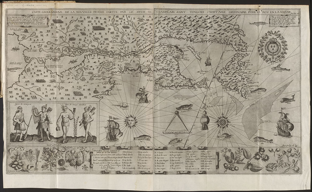
Carte geographique de la Nouvelle Franse faictte par le sieur de Champlain, 1613 [Geographical map of New France by Samuel de Champlain, 1613]. Samuel de Champlain’s beautiful illustration advertises the land’s wealth to investors (MIKAN 3919638 or AMICUS 4700723)

Continue reading