The Expropriation of LeBreton Flats (1962)

Version française

By Ariane Gauthier

LeBreton Flats was once one of the oldest neighbourhoods in Ottawa. It began as the home of many lumber mills as early settlers sought to use the strong current of the Chaudière Falls to move massive quantities of lumber from a densely forested area. With this industry came its horde of workers, who chose to establish their families near their workplaces. These were the principal elements that helped to shape the Flats.

Map of Ottawa showing part of the so-called Lumber District, including the Ottawa River and the Chaudière Falls.

Insurance plan of Ottawa, Ontario, June 1878 – Sheet 3. (e010695480)

Despite the lively atmosphere prompted by this active industry and the additional hustle and bustle of the railway yards, LeBreton was an impoverished area mostly populated by Francophones, the Irish and, later, Italians. Still, the Flats endured. Even after the Great Fire of Ottawa-Hull—a massive fire that erupted in Hull, Quebec, on April 26, 1900, and jumped the Ottawa River to decimate parts of Ottawa—reduced the area to ashes, the neighbourhood was quickly rebuilt and life picked up where it had left off.

Black-and-white photo depicting thick columns of billowing smoke suffocating the LeBreton Flats area, as seen from Parliament Hill.

Great Fire of Ottawa-Hull. (a009286)

Things changed, however, on April 18, 1962, when the National Capital Commission issued a letter to the residents of the Flats informing them of their abrupt expropriation. Residents and business owners had until May 1, 1964—this date was later revised to December 31, 1964—to vacate their homes, after which plans had been made to raze everything to the ground. On the bones of this old neighbourhood, a massive new building for the Department of National Defence would take shape, destined to serve as its headquarters.

However, these ambitious plans were then abandoned. In 1965, after the final building was knocked down, Ottawa residents waited to see what would become of the vacated LeBreton Flats. None could have guessed that any plans to remake the area would be tabled for some 40 years.

In my search to understand this part of Ottawa history, I often found myself wondering about the families who had to leave their homes: those who had inherited familial houses they had known their whole lives, the new immigrants who had so recently settled into the city, and the business owners who had once served as the life force of LeBreton Flats. How sad it was to think about their lost dreams, ambitions and memories!

Plowing through our vast archival collection in a bid to find personalized experiences of the expropriation, I came across the following sub-series from the National Capital Commission fonds (RG34/R1181):

Central registry files
Reference: R1181-18-X-E, RG34-C-1-b
http://central.bac-lac.gc.ca/.redirect?app=fonandcol&id=134479&lang=eng

The central registry files mostly pertain to the management of National Capital Commission properties through negotiations and transactions to acquire and expropriate property. Among other things, they include many files on residences and businesses expropriated from the Flats in 1962. Uniquely, many of these files include photos of houses, apartment complexes, stores, etc., which figure as the core motivator for this blog post, particularly photos of buildings and streets that no longer exist.

Black-and-white photo of a man walking past a two-storey apartment building.

Man walking in front of apartment unit. The photograph is dated June 1962. (Photo taken by Ariane Gauthier – from R1181-18-X-E, box: 77.)

Black-and-white photo of a two-storey building with a corner store on the ground floor and apartments on the second floor.

A self-service corner store. (Photo taken by Ariane Gauthier – from R1181-18-X-E, box: 77.)

Three black-and-white photos of a two-storey apartment building. Top photo is the front view. Bottom left photo is the rear view, with clothing hanging from two clothing lines. Bottom right photo is the side view.

Three photos of the same apartment unit: front view, rear view and side view of the property. (Photo taken by Ariane Gauthier – from R1181-18-X-E, box: 77.)

Two black-and-white photos of a two-storey apartment building. Top photo is the front view. Bottom photo is the rear view.

Front and rear views of the Ottawa Feather & Mattress company building. (Photo taken by Ariane Gauthier – from R1181-18-X-E, box: 77.)

This is just a sample of what can be found by going through these files. Much more can be learned by carefully examining the textual documents accompanying these photos, but this is work I will leave to city historians.

After the neighbourhood was levelled in 1965, replaced by grass fields and shrubs, the Flats sat empty for some 40 years until the Canadian War Museum opened its doors in 2005. The construction of condo buildings and parks followed five years later. In 2019, the development of the City of Ottawa’s O-Train Confederation line led to the opening of Pimisi Station, which serves the LeBreton Flats area. Ongoing projects are seeing the area filled once again with new residential buildings, a possible hockey arena and, of course, Ādisōke. This shows us that the expropriation of 1962 was not the coup de grâce for LeBreton Flats. Just like after the Great Fire of Ottawa-Hull, LeBreton Flats is rebuilding and will soon continue from where it left off.

Additional Resources


Ariane Gauthier is a Reference Archivist in the Access and Services Branch at Library and Archives Canada.

The Life of Private Marcel Gauthier (Part 1)

Version française

By Ariane Gauthier

I learned about Marcel Gauthier a few years ago when I was visiting the Canadian cemetery in Beny-sur-Mer in France. Although we have the same last name, Marcel is not my ancestor. However, I have always kept a memory of this young man—the only Gauthier buried in this large cemetery. With the release of the 1931 census, I finally had the opportunity to learn more about him. Now, I would like to demonstrate how the many resources of Library and Archives Canada (LAC) can help piece together the life of a person, such as an ancestor or a soldier!

This first part of the blog will cover Marcel Gauthier’s life from his childhood to his military enlistment.

A black and white picture of a young man in his military uniform.

Photograph of Private Marcel Gauthier, age 21, published in an Ottawa newspaper to announce his death overseas (Canadian Virtual War Memorial).

Private Marcel Gauthier (Joseph Jean Marcel Gauthier)

  • C/102428
  • Le Régiment de la Chaudière, R.C.I.C.
  • Date of birth: November 18, 1922
  • Date of death: July 15, 1944
  • Age at time of death: 21 years old

His military service file is available in LAC’s War Dead database, 1939 to 1947.

Born on November 18, 1922, in Ottawa, Ontario, Marcel Gauthier is the seventh child of a large French-Canadian family of nine. When we look at the Gauthiers in the censuses, we learn that Henri, the father of the family, is from Rigaud, Quebec. When he arrived in Ottawa, he settled in Lowertown with his family. This is where Marcel built his life before enlisting.

At that time, Ottawa’s Lowertown attracted many Franco-Ontarians. The 1931 Census shows that the homes and dwellings of the By Ward – St. George’s Ward sub-district were largely inhabited by French Canadians. Some of them were born in Ontario, others came from Quebec. Several historical studies indicate that the population of Lowertown was mainly Francophone, with a significant Irish population as well. This is one of the reasons why this area has been the site of many language issues in the history of Franco-Ontarians, particularly on the issue of Regulation 17 (available in French only), adopted in 1912. Additional resource: https://www.thecanadianencyclopedia.ca/en/article/ontario-schools-question.

Screenshot of the 1931 Census, with an arrow indicating where Marcel Gauthier’s information is found.

Screenshot of the 1931 Census. Marcel Gauthier’s name is found on the 48th line of the By Ward – St. George’s Ward sub-district, No. 74 (Lowertown), on the 7th page of the document (record 8 of 13). He was nine years old at the time (MIKAN 81022015).

Lowertown was considered a disadvantaged neighborhood with a predominantly working-class population. We can therefore assume that Marcel was not born into wealth. His large family lived in close quarters, first at 199 Cumberland Street, with at least seven children (1921 Census), then at 108 Clarence Street, with nine children (1931 Census).

The absence of his mother, Rose Blanche Gauthier (née Tassé), from the 1931 Census indicates that she had probably died by this time. We can assume, by referring to the 8th page of the document (or record 9 of 13), that she died between 1928 and 1931. This theory is based on the registration of the youngest family member, Serge Gauthier, three years old at the time. Marcel’s military record validates this theory and confirms Mrs. Gauthier’s death on October 6, 1928, possibly due to complications arising from the birth of her last child. She is buried in the Notre-Dame Cemetery in Carleton Place, Ontario, where she was born.

In 1931, Marcel’s father and eight of his children lived in a nine-bedroom apartment at 108 ½ Clarence Street. If it had not been for the help of the older children, Henri’s mail carrier salary would not have been sufficient to support his children and cover their tuition. We can therefore assume that Yvette (24 years old and single), the oldest in the household, looked after the home and the younger siblings. We also know that Léopold (22 years old) worked as a driver and that Marie-Anne (21 years old) was a salesperson. It is very likely that they were helping their father financially, just as their older sister, Oraïda (27 years old), had more than likely done ten years earlier. She had now moved out and married a Mr. Homier.

In 1931, Marcel became a student and learned to read, write and communicate in English. At 16, he completed his education. He entered the workforce as a cook and then moved alone to 428 Rideau Street.

Photograph of a two-storey building. Bowles Lunch restaurant is located on the first floor.

Bowles Lunch restaurant where Marcel Gauthier worked before enlisting in the army in 1943 (a042942).

In Europe, tensions with Hitler’s Germany escalated and led to the outbreak of World War II in 1939. Unlike many young men, Marcel did not immediately feel the need to join the fight, likely because he was satisfied with his job as a cook at Bowles Lunch. He waited until January 11, 1943, before reporting to Enlistment Office No. 3 in Ottawa. We can theorize that, like many, he wanted to help change the course of the war or that he wanted to follow the example of two of his brothers, Conrad and Georges Étienne.

Shortly after, on January 29, 1943, he left Ottawa to begin training in Cornwall, unaware that he was leaving his hometown forever.

Additional resources


Ariane Gauthier is a reference archivist in the Access and Services Branch at Library and Archives Canada.

That sinking sensation: Leda clay in and near Ottawa

Version française

By Ellen Bond

In the 1970s, there were two shows I looked forward to every weekend: The Wonderful World of Disney on Sunday (feel-good stories) and The Bugs Bunny/Road Runner Hour (cartoons) on Saturday. It wasn’t the ACME dynamite or the crazy coyote that scared me on Saturday—it was the quicksand! Being stuck in cement-like mud sounded horrendous to me. So imagine my feelings when I learned that most of Ottawa is built over a massive amount of Leda clay, which can liquefy from ground tremors, forming a type of quicksand. Quicksand? Here in Ottawa? Not only in the desert of Wile E. Coyote? Yikes!

A colour map showing the area of land covered by the Champlain Sea

A map showing the former location of the Champlain Sea after the last period of glaciation (Wikipedia) Credit: Orbitale

The Champlain Sea and the formation of Leda clay

After the last ice age, the climate warmed and the snow and ice melted. Massive spillways, which carried melting glacial waters and looked like enormous rivers, moved the water away from the remaining glaciers and sometimes formed lakes. In the area now known as the Ottawa Valley, a vast inland shallow sea formed 15,000 years ago. Geologists named it the Champlain Sea. What is unique about this sea is the Leda clay that was deposited in areas of deeper water.

You may wonder what happened to the Champlain Sea and why these lands are not still underwater. There are two reasons: evaporation and the rebounding of land once freed from the incredible weight of a 1- to 3-kilometre deep glacier. The land previously under the glaciers in North America is still rebounding today, 15,000 years later!

Leda clay (also known as quick clay and Champlain Sea clay) was formed by sediment eroding from the earth and landing at the bottom of the sea. The Champlain Sea was full of both fresh water from the glacial melt and salt water from the ocean. When salt molecules combine with the clay molecules, it makes a stable clay. But if fresh water infiltrates the clay and washes away the salt, the clay becomes very unstable. An unstable clay molecule is prone to liquefying.

Why doesn’t Leda clay liquefy more often?

You may wonder why the Leda clay under Ottawa and the lands around the St. Lawrence River doesn’t liquefy all the time. For the most part, the clay is underneath the surface and away from fresh water, and so is very stable. However, earth tremors, whether natural (earthquakes, erosion) or human created (explosions, blasting, digging), can allow fresh water to seep into the Leda clay, removing the salt molecule. If that clay is on a hill or on the edge of a winding river, this leads to landslides.

Leda clay has been found responsible for over 250 landslides in Canada alone. In the Ottawa area, Leda clay was responsible for the Canadian Museum of Nature building’s tower sinking in 1915 and, more recently, holding up new developments in Ottawa South in 2021. It was also responsible, in part, for the Rideau Street sinkhole that appeared with train construction in downtown Ottawa in 2016.

The landslide disaster at Notre-Dame-de-la-Salette

Notre-Dame-de-la-Salette is in the area formerly covered by the melt waters from the Champlain Sea. The village is northeast of Ottawa, in Quebec, and marked by an orange star in the map of the Champlain Sea above.

Disaster struck in the middle of the night in Notre-Dame-de-la-Salette on April 26, 1908, when a riverbank of the frozen Lièvre River gave way. Fresh water had infiltrated the Leda clay molecules, making them unstable, and the riverbanks collapsed, propelling a wave of mud, ice and ice-filled water across the river and into the town. Thirty-four people lost their lives and at least twelve homes were destroyed.

A river with tree stumps on the left side and homes on the right side.

Looking up Lièvre River from Notre-Dame-de-la-Salette, Quebec (a040044-v6)

Water moves in a straight line until it meets resistance. In this historical photo of the area, the water in the river is flowing towards the riverbank (blue arrow), and it was here that the riverbank gave way. Labelled in green you can see the stumps left behind following the clearcutting of trees along the bank. Without the layer of trees to protect the bank, the entire area was prone to eroding quicker than before the cut. Some of the village of Notre-Dame-de-la-Salette can be seen across the river from where the landslide occurred. At this time, there is no island in the middle of the river, and there are houses close to the river on the town side. Comparing this image to ones after the slide, there is a stark difference. Look for changes to this scene in some of the photos that follow, especially house placement.

A river cutting through a hilly landscape with houses along the river.

Southeast view of the Lièvre River Valley and Notre-Dame-de-la-Salette (a044070-v8)

Another old photo from the LAC collection shows the river flowing away from the viewer. Look closely, and you can see where the earth gave way and the island formed in the middle of the river after the landslide.

A river with hills in the background. There is a small island in the river and a bridge farther upstream.

Former town site of Notre-Dame-de-la-Salette, Lièvre River, Quebec. Photo looks upstream. (a020267)

In the photo above, the river is flowing towards the viewer, and you can see the bridge crossing the river, north of town. A red arrow points to where the riverbank gave way during the landslide. A new island formed in the middle of the river from the sediment and material moved in the slide. The other change is that there is now a clearing where the town site had been—people rebuilt the town further away from the river.

A white cross on the edge of a ridge. The land below the ridge is considerably lower than the ridge.

A white cross stands on the edge of where the land gave way in 1908, leaving a scar on the land still visible today. Photo credit: Ellen Bond

The colour photo above was taken recently, and you can see the area affected (where the land gave way along the ridge), the island formed from the slide and a memorial white cross on the hill.

A river bend with water flowing towards the shoreline of the bend.

A recent photograph of the area affected by the landslide. Photo credit: Ellen Bond

The above photo looks downstream at the slide location. The slide area is shown in yellow, and you can see the ridge above. On the left, you can see the edge of the island that formed after the slide.

A large rock with a metal plaque describing the event and the names of the victims. The rock is across from the slide location. There is a bench nearby overlooking the memorial and the landslide site.

A memorial across the river from the slide location. Photo credit: Ellen Bond

Inscription on plaque reads: Memorial On April 26th 1908 around 3:30 am, the village was brutally awakened by a loud grumbling noise. A 1200 foot long by 500 feet deep piece of land on the west side of the river suddenly slipped in the river, sweeping in a mass of water, ice and clay, houses, buildings and 34 victims. Ten (10) of the thirty four (34) victims were never found.

A memorial plaque located near the landslide area. It describes the event and lists the names of the victims. Photo credit: Ellen Bond

Although this landslide occurred over 110 years ago, the effects can be still seen and felt today. In the middle of the night, due to no fault of their own, 34 people lost their lives tragically and unexpectedly. Their names, in each family group, were

  • Alexina, Amanda, Adélard and William Charron-Lamoureux,
  • Cléophas Deslauriers, Célina, Damien, Wilfrid, Albert, Lucien, Béatrice and Alice Deslauriers-Paquin
  • Émélie, Florimond and Alias Desjardins-Gravelle
  • Émélie, Daniel, Eddy, Arthur, Angus and Henri Lapointe Labelle,
  • Rose-Anna, Camille, David, Emma, Rose and Albert Larivière-Charron,
  • Alexina, Arsidas, Wilfrid, Florida and Anna Murray-Légaré
  • Georges Morrissette
  • Adélard Murray

The power of the earth is incredibly strong, and those that inhabit the planet are sometimes the unfortunate recipients of its fury. It happens in regions affected by hurricanes. It happens where two of the Earth’s plates meet and are moving in different directions. It happens where Leda clay has formed. As humans, we cannot control this power. In Notre-Dame-de-la-Salette, the people have adapted to the Leda clay by moving their houses away from the river. Unfortunately, lives were lost learning this lesson. RIP to all of the victims and their families.

A recent photo of the slide area.

Looking across the river to the slide location. The ridge is visible as is the island. Photo credit: Ellen Bond

Additional Resources


Ellen Bond is a project assistant with  the Online Content team at Library and Archives Canada.

Women’s hockey: She shoots, she scores!

Version française

By Ellen Bond

In January 2020, the Canadian men’s team won the gold medal against Russia at the 2020 International Ice Hockey Federation (IIHF) World Junior Championship. It was a hard-fought competition with millions watching from all over the world. This is any Canadian hockey player’s dream: winning gold at an international championship and hearing your national anthem at the end of the game. Meanwhile, only a few days earlier, Team Canada played against the United States of America (USA) in the 2020 IIHF Ice Hockey U18 Women’s World Championship with, by comparison, almost no one watching.

Unlike basketball, which has different sized balls, and volleyball, which has different net heights, hockey is the same game for men and women. Yes, women play “non-contact” hockey, but the ice surface is the same, the puck size and weight are the same, and the nets are of equal height, width and depth. Both men and women began playing hockey in its infancy (men in early 1870s and women in 1890s). This begs the question: Why did men’s hockey continue to grow and develop, while women’s hockey had a great start but then failed to gain the same attention?

A black and white photo taken outside with women in long skirts.

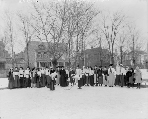
A group of women gather to play hockey in 1906, Ottawa, ON (PA-042256)

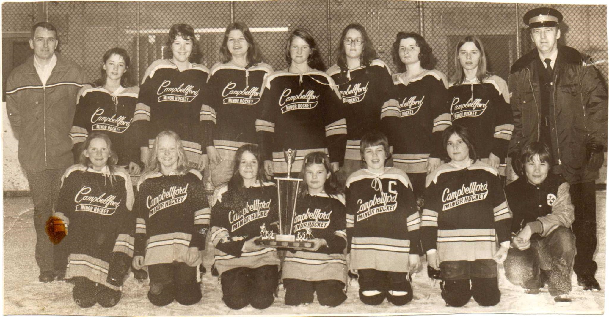
When I was young, all I wanted to do was play hockey. I remember watching my brother play with lots of other boys out on the ice. They would divide the ice up with long hoses across the blue lines to make up three smaller ice surfaces. I wanted to be out there, but girls were not allowed. That changed in the late 1970s when we moved to Campbellford, Ontario. One day in early fall, a man came to our door and asked my dad if he wanted to coach the girls’ hockey team. He said yes and, at the beginning of grade eight, I started playing organized hockey.

A sepia photo of a girls’ hockey team with Campbellford Minor Hockey written on their sweaters.

My championship team the first year I was allowed to play hockey. My dad is on the right and my brother is kneeling in front of him. I’m in the top row, third from the left. (Photo supplied by the author.)

This made me wonder: If women, like men, started to play hockey in the late 1800s, why wasn’t I allowed to play hockey prior to our move to Campbellford, when we had lived in a moderately large city?

A black and white photo of a woman dressed in a skirt to play hockey outside.

“Queen of the Ice.” A woman stands on ice wearing figure skates and holding a hockey stick, 1903. (C-3192610)

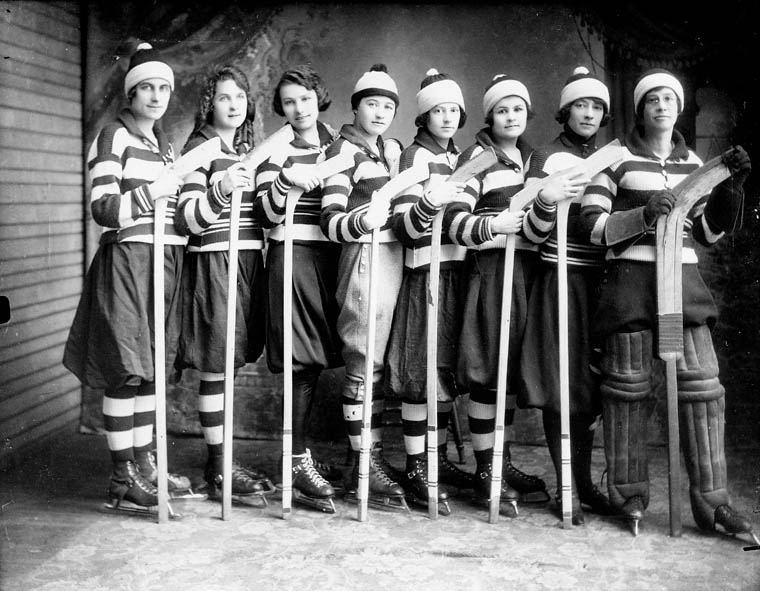
The Ontario Women’s Hockey Association (OWHA) claims the first women’s hockey game took place in 1891 in Ottawa, Ontario. At this time, the University of Toronto (U of T), Queen’s University and McGill University had women’s hockey teams, but they had to compete behind closed doors. Men couldn’t watch and the only men allowed inside were the referees. In 1914, the first women’s provincial championship took place in Picton, Ontario. There were six teams involved, including some of the university teams. In 1921, U of T defeated McGill to win the first Canadian women’s university championship. These teams and others helped the game grow steadily but unevenly in the 1920s and 1930s.

Then women’s hockey just stopped growing. Maybe it was because hockey was “too rough for girls,” as Clarence Campbell, President of the National Hockey League, argued in 1946. Maybe it was because communities prohibited people from watching women play hockey. Maybe it was because of beliefs that watching women play hockey was too frivolous or that women took the game too seriously. Or maybe, as Wayne Norton suggests in his book Women on Ice: The Early Years of Women’s Hockey in Western Canada, it was because in 1923 the Canadian Amateur Hockey Association (CAHA) voted NOT to give women official recognition as hockey players. In their book, Too Many Men on the Ice: Women’s Hockey in North America, Joanna Avery and Julie Stevens propose that Canada’s participation in the Second World War led to the decline of women’s hockey. Many women took on factory jobs when the majority of men went to fight in the war, leaving them little time to play the game. Whatever the reason, for decades it was hard for women to play a beloved game and this meant that many girls and women never had the opportunity to play hockey.

A black and white photo of a woman as a professional hockey player.

Miss Eva Ault. When men headed to Europe in the First World War, women got their first chance to play professional hockey. Eva Ault became a fan favourite, but when the war ended so did the careers of the first female pros. (PA-043029)

A black and white photo of a women’s hockey team lined up with the butt end of their sticks on the ground and dressed in their team uniform.

Women’s hockey team from Gore Bay on Manitoulin Island, Ontario, 1921. Names available in the record. (PA-074583)

I had the opportunity to play hockey from grades eight to thirteen, both in my community and at my high school in Peterborough, Ontario. I was also fortunate to have varsity teams to play on at McMaster and Queen’s universities. This was the closest I ever got to playing professional hockey. We were provided with equipment, ice time for practices and games, and transportation to all our games. At McMaster the entire budget for our team was less than the men’s team spent on sticks alone, but I had the chance to play varsity hockey for my university and to play with and against some of the best players in the world.

Two of those players were Margot (Verlaan) Page and Andria Hunter. Both of these athletes wore the Team Canada jersey at World Championships. I played with Margot for three years at McMaster. She was our captain and the best player out on the ice. At the time, this was the highest level of hockey Margot could play. She went on to play for Canada at the IIHF World Championships in 1987 (not sanctioned), 1990, 1992 and 1994. From 2000–2007 Margot coached Canada’s IIHF and Olympic women’s hockey teams. Margot is now Head Coach of the Brock Badgers Women’s Varsity Ice Hockey Team. Andria and I knew each other from living in Peterborough and because I was a counsellor at Camp Quin-Mo-Lac when she was a camper. Living in a small town, our paths crossed numerous times. I asked Andria what it was like when she first played hockey. Here is her story, in her own words.

I first started playing hockey in 1976. At that time, it was not very common for females to play. I was fortunate to play in Peterborough when girls’ hockey was just taking off. There were many small towns that had no female hockey at all at that time. I played in a boy’s house league my first year, but after that I was always able to play girls’ hockey.

When I was a kid, it was always my dream to play university hockey, because that was the highest level at the time; there was no national team, and certainly no World Championship or Olympics. I was very fortunate that some major changes in women’s hockey happened at an ideal time for me. I went on to play university hockey in the USA on a hockey scholarship; I was one of the first international female players to receive a women’s hockey scholarship in the USA. I also had the opportunity to play for Team Canada in 1992 and in 1994! I have always thought that if I had been born just five years earlier, I may have missed these amazing experiences.

I played at the University of Toronto as a graduate student between 1990 and 1996. During these years, the program went through a tumultuous period of transition. In 1990, our team kept our equipment in a small locker and our games were only three fifteen-minute periods with one flood. Then, during the 1993–94 season (when I was away from U of T playing hockey in Switzerland), the women’s hockey program was almost cancelled. There was a big rally that helped to keep the program alive. When I returned from Switzerland the next year to play for U of T again, women’s hockey had been upgraded to a high-performance sport. We now had two-hour practices four days a week, and no longer had to keep our equipment in a storage locker!

I played in the National Women’s Hockey League (NWHL) when it was in its infancy. We had an enthusiastic owner when I played for the Mississauga Ice Bears who arranged for us to play at the Hershey Centre [now the Paramount Centre] and we even had our own dressing room there. Unfortunately, we just did not get enough fans to allow us to play in such an expensive venue so, after two seasons, the team moved to Oakville.

Since my retirement from the NWHL in 2001, women’s hockey has continued to grow. It is certainly much more socially acceptable for females to play [now] than it was when I was a kid. The skill level has increased, as players get more development opportunities. The quality of the coaching, the level of competition, and the amount of ice time at the grassroots level, are certainly contributing factors. The number of teams at the university level in both Canada and the USA and the amount of resources for these players has continued to increase as well. It is unfortunate that women’s hockey still struggles to attract fans and that there are limited professional opportunities for women’s hockey players today. Fortunately, there are an increasing number of employment opportunities for women in coaching positions.

A black and white photo of a women’s hockey team. The women have team sweaters on and are holding their hockey sticks.

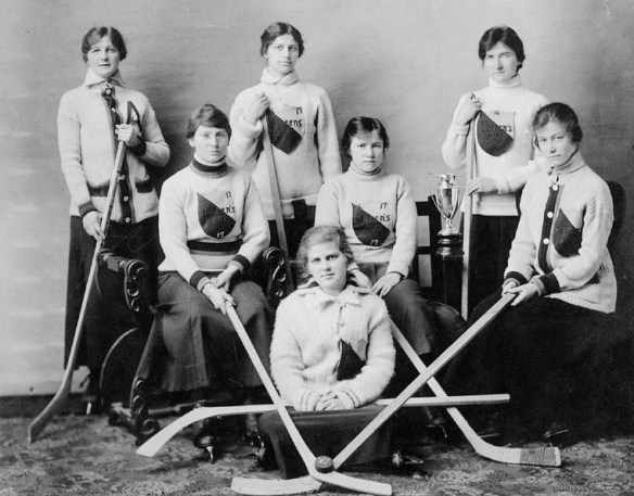
Team portrait of Queen’s University women’s hockey team, 1917. Some names are available in the record. (PA-127274)

Like Andria says, girls today have many opportunities to play hockey. Teams are available in many communities across Canada. Girls can aspire to play varsity hockey at many Canadian universities, to play in Division I of the National Collegiate Athletic Association (NCAA) in the United States, and to play in many European countries. They can dream about playing for their country at the Olympics and in the World Championships. Elite players from Canada and the USA played 3-on-3 games during the 2020 Honda NHL All-Star Weekend in St. Louis, Missouri, showing their skills to million of fans. As the game continues to grow, competition between countries will increase and maybe the NHL will offer a women’s professional league to play in. The future is bright for the young girls of today who yearn to play hockey. Margot, Andria and I gained many life lessons from playing hockey growing up and we are so excited for the girls of today and the opportunities that await them playing the great game of hockey.


Ellen Bond is a project assistant with the Online Content Team at Library and Archives Canada

Dressing Up at Ottawa’s Fancy Dress Balls and Skating Carnivals (1876–1896)

By: Emma Hamilton-Hobbs

Don’t you just love to dress up, spending hours upon hours devoted to selecting, conducting research on, and finally creating an impressive outfit for an exclusive costumed event? Well, many Canadians in the late nineteenth century certainly did!

A fancy dress ball was a private costumed party that grew in popularity over the course of the nineteenth century, hosted and attended primarily by the most privileged members of society. The men and women who received invitations to the events spent weeks upon weeks carefully selecting their costumes, poring over published magazines and books devoted to fancy dress, and even perusing historical books or paintings for inspiration. Popular ideas included historical dress, literary, mythological and allegorical characters, and finally, characters from “exotic” lands.

Newspapers in Ottawa, Toronto and Montreal reported extensively on the major Canadian fancy dress balls, providing detailed descriptions of the various costumes that the elite guests had worn. Many who attended the balls eagerly flocked to photography studios in the days and months following these special occasions to have their portraits taken in costume. Sometimes these portraits were used to create impressive composite photographs, including the one fabricated by Ottawa photographer William James Topley (1845–1930) of the Grand Fancy Ball hosted by Governor General Lord Dufferin and his wife Lady Dufferin in the Rideau Hall ballroom on February 23, 1876.

A group photograph of hundreds of costumed guests at a fancy dress ball. The background is a painting of the Rideau Hall ballroom.

Composite image of the Dufferin Grand Fancy Ball at Rideau Hall on February 23, 1876. The final composite was completed in either May or June. (e008295343).

This composite was created by pasting hundreds of individual portraits taken in Topley’s studio onto a painted scene of the Rideau Hall ballroom, which was then re-photographed to create the final product. Topley learned how to create composite images from his former mentor and employer, William Notman (1826–1891), who owned a successful photography studio in Montreal. Topley, like Notman, was an astute businessman who took full advantage of these vice-regal events to turn a profit, as guests were eager to have their costumed characters preserved in the form of photographic portraits that they could share with family and friends, or paste into personal albums as memorable keepsakes.

Many individuals played up their character in the photography studio, assuming different poses and using a variety of props in their staged portraits. Mr. Campbell posed theatrically as a “Court Jester” when he visited Topley’s studio shortly after the Grand Fancy Ball hosted by the Dufferins had ended. William Campbell was the private secretary to Lord Dufferin and a well-liked staff member.

A black-and-white photograph of a man dressed as a jester and posing in a photography studio. He grasps a puppet on a stand in his right hand.

William Campbell, private secretary to Lord Dufferin, as a “Court Jester” by William Topley, March 1876. (e011091709)

Miss Maggie Jones and Miss Zaidee Cockburn both dressed up as “Bonnie Fishwives of New Haven” at the Dufferins’ Grand Fancy Ball. They attracted some attention throughout the evening, which may have been linked to the lengths of their skirts, which were much shorter than acceptable Victorian dress.

A black-and-white photograph of a young woman dressed up as a “fishwife” and posing in a photography studio. She is shown standing with her left hand resting on her hip, her other hand holding a papier mâché fish and her right foot raised and leaning on a wooden barrel.

Miss Maggie Jones dressed as a “Bonnie Fishwife of New Haven” by William Topley, March 1876 (e011091718).

Fancy dress skating carnivals were also very popular during this time, and, unlike the fancy dress balls, were far more accessible to the average Canadian citizen. In his studio, Topley recreated outdoor skating scenes for his sitters with a painted, snowy backdrop complete with artificial snow and a reflective surface to imitate ice. Women loved to wear peasant or pastoral dress to skating carnivals, as shorter skirts also allowed them to move around freely on skates.

A black-and-white photograph of a woman dressed up in costume as a shepherdess on skates in a photography studio. The backdrop is a painted, snowy scene.

Miss Fraser as a “Shepherdess” by William Topley, February 1889 (a138398)

Allegorical characters were also well represented at the fancy dress balls and skating carnivals. Women dressed as “Night,” “A Hornet,” “The Alphabet,” or even as the “Dominion of Canada,” as represented by Mrs. Juschereau de St. Denis LeMoine at the Dufferins’ ball.

A black-and-white photograph of a woman dressed up as the “Dominion of Canada” in a photography studio. On the front of her dress is the coat of arms of the Dominion surrounded by embroidered maple leaves, with miniature snowshoes on the train of her dress.

Mrs. Juschereau de St. Denis LeMoine as the “Dominion of Canada” by William Topley, March 1876. (e011091705)

A black-and-white photograph of a man dressed up as explorer “Jacques Cartier” in a photography studio.

Mr. Juschereau de St. Denis LeMoine dressed as explorer “Jacques Cartier,” March 1876. (e011091707)

The Historical Fancy Dress Ball hosted by the Governor General, the Earl of Aberdeen, and his wife, Lady Aberdeen, in the Senate Chamber of the original Parliament buildings on February 17, 1896, was another widely reported event. This educational ball featured nine periods in Canadian history, from the Vikings to the Loyalists, enacted by two hundred and fifty individuals in a series of dances at the ball.

A photographic portrait of a group representing the voyages of the Norsemen at the Aberdeens’ ball illustrates how the medium of photography had evolved since the Dufferins’ ball twenty years earlier. Topley, who once again photographed the groups in his studio after the ball had ended, could now take an entire group together as a result of faster exposure times. The scene is also illuminated by natural light streaming in from the skylight seen at the top left of the image.

A black-and-white photograph of a group of seventeen men, women and girls wearing Viking costumes in a photography studio.

A historic group representing the voyages of the Norsemen to Northeastern North America photographed in Topley’s studio. They were the first historic group who performed a lively “polska” at the Historical Fancy Dress Ball hosted by Lord and Lady Aberdeen in February 1896. The young girl seated in the middle is Lady Marjorie Gordon, daughter of the vice-regal hosts, wearing a white and gold dress with her mother’s Celtic jewellery. (a137981).

A souvenir album was created and sold to guests afterward as well, illustrated with photographs of the historic groups taken by Topley (with the exception of one group) and text by historian and civil servant Dr. John George Bourinot, who provided advice and guidance to Lady Aberdeen in the months leading up to the event. Library and Archives Canada (LAC) has a copy of this souvenir album in its collection.

All of the above digitized images were reproduced from original glass plate negatives found in the Topley Studio fonds at LAC. These images, along with many others taken by Topley of guests who attended the Ottawa fancy dress balls and skating carnivals, are available online through LAC’s website.

Reproductions of these original glass plate negatives are on display at the National Gallery of Canada in the Canadian and Indigenous Galleries.


Emma Hamilton-Hobbs is a photo archivist in the Government Archives Division at Library and Archives Canada.

Louis Riel’s ill-fated Ottawa journey

Version française

On the left of the graphic, Tatânga Mânî [Chief Walking Buffalo] [George McLean] in traditional regalia on horse. In the middle, Iggi and girl engaging in a “kunik”, a traditional greeting in Inuit culture. On the right, Maxime Marion, a Métis guide stands holding a rifle. In the background, there is a map of Upper and Lower Canada, and text from the Red River Settlement collection.By Anna Heffernan

This article contains historical language and content that may be considered offensive, such as language used to refer to racial, ethnic and cultural groups. Please see our historical language advisory for more information.

During his lifetime, Louis David Riel was a controversial figure—a leader of two uprisings, regarded as either a hero or a traitor—but today he is recognized for his contributions to the development of the Métis Nation, the province of Manitoba, and Canada. In 1992, he was named a founder of Manitoba, and in 2016, he was recognized as the province’s first leader. Since 2008, the third Monday in February has been celebrated as Louis Riel Day in Manitoba.

Library and Archives Canada (LAC) has a rich selection of materials relating to Louis Riel and the movements he led. The We Are Here: Sharing Stories project digitizes Indigenous-related materials in LAC’s collections. One of our priorities is to digitize the documentary legacy of Riel to make it more accessible to Métis Nation communities and researchers. While Riel is one of Canada’s most famous historical figures, some aspects of his life story are less known.

Most Canadians will recall that Louis Riel led the Red River Resistance in 1869–1870. At this time, the Hudson’s Bay Company sold their rights to Rupert’s Land, granted to them by the British Crown, to the Dominion of Canada. Métis Nation and First Nations peoples who traditionally inhabited the area did not recognize the Hudson’s Bay Company’s claim to the land, and therefore saw this as an illegitimate sale. In response to the sale of their homelands, Louis Riel and his colleagues formed a provisional government, pictured below, at Fort Garry.

A black-and-white photograph of 14 men, arranged in three rows (the front two rows sitting and the back row standing), with Louis Riel seated in the centre.

Louis Riel (centre) with the councillors of the provisional government in 1870. (a012854)

However, not everyone supported Riel’s provisional government. A group of Ontario settlers were captured by the provisional government’s forces while preparing to attack Fort Garry. One of the group, Thomas Scott, was executed for insubordination on March 4, 1870. Despite this incident, negotiations with Canada continued, and Riel successfully negotiated the terms of Manitoba’s entry into Confederation. When the negotiations were complete, a military expedition was sent from Ontario to enforce Canadian control over Manitoba. Many in Ontario viewed Riel as a traitor and murderer for the execution of Thomas Scott. Fearing for his life, Riel fled to St. Paul, Minnesota.

One of the less-well-known stories of Louis Riel’s life is his ill-fated journey to Ottawa. In 1873, Riel was elected as the Member of Parliament for Provencher, Manitoba, and he was re-elected twice in 1874. Riel travelled to Ottawa to take his seat, but his foray into federal politics was to be short-lived. His attempt to sit in the House of Commons is documented in our collection by some interesting material. The first item is the test roll bearing his signature, pictured below, which every Member of Parliament signed upon taking the oath.

Page with six columns of signatures. Louis Riel’s signature is seen at bottom right.

Page from the House of Commons test roll signed by Louis Riel. (e010771238)

Going to Ontario at this time was an enormous risk for Riel. After the execution of Thomas Scott, Ontarians reacted with anger—particularly Protestants, because Scott had been a member of the Orange Order, a Protestant fraternal organization. In response, the premier of Ontario offered a $5,000 reward for Riel’s capture, and a warrant was put out for his arrest. In Parliament, a motion to expel Riel was brought by Mackenzie Bowell, an Orangeman from Ontario. The motion passed, and Riel would not return to the House of Commons, despite being re-elected a third time. The second piece of material relating to Riel’s journey to the capital is the photograph below. Before leaving hastily, Riel had his photograph taken in Ottawa, inscribed with the caption “Louis Riel, MP.”

Sepia-tone vignette photograph of Louis Riel facing the camera, with handwritten inscription underneath reading “Louis Riel, MP.”

Studio portrait taken in Ottawa after Riel was elected as the Member of Parliament for Provencher, Manitoba. (e003895129)

In 1875, Riel went into exile in the United States. From 1879, he lived in Montana Territory, where he married Marguerite Monet, dite Bellehumeur, in 1881. They had three children. He followed the buffalo hunt and worked as an agent, trader, woodcutter and later teacher. Riel returned to Canada, to Batoche in what is now Saskatchewan, in July 1884.

The test roll and the photograph of Riel in Ottawa are examples of how even some of the small items in our collection can illuminate moments in Canadian history. By researching and digitizing more of the Indigenous documentary heritage in our collections, we aim to share the stories not only of famous figures like Riel but also of many other Indigenous people in Canada.

This blog is part of a series related to the Indigenous Documentary Heritage Initiatives. Learn how Library and Archives Canada (LAC) increases access to First Nations, Inuit and Métis Nation collections and supports communities in the preservation of Indigenous language recordings.


Anna Heffernan is an archivist/researcher for We Are Here: Sharing Stories, an initiative to digitize Indigenous content at Library and Archives Canada.

Recent documents digitized through the DigiLab

By Karine Gélinas

The DigiLab is a new hands-on facility for clients to digitize and contextualize documents from the Library and Archives Canada (LAC) collections. Since its launch in 2017, the DigiLab has hosted more than 30 projects that have resulted in the digitization of over 30,000 pages of textual material and 9,000 photographs.

A colour photograph of a room containing a large-format scanner on a table in the foreground, a series of shelving on the left side, and two people sitting at workstations in the background.

The DigiLab space at 395 Wellington. Photo by Tom Thompson.

One of the projects hosted in the DigiLab was with the National Capital Commission (NCC), which digitized stunning historical images of the National Capital Region. You will find below some of the material the NCC digitized that is now available on LAC’s website.

Albums from the National Capital Commission fonds

  • Aerial views of Ottawa, 1952–1962 (8 images) – MIKAN 5025694
  • Federal District Improvement Commission, 1927–1929 (56 images) – MIKAN 5016537
  • Federal District Commission, 1927–1932 (291 images) – MIKAN 5023881
  • Photos by R.A. Ramsay showing installation of a steel railway structure (4 images) – MIKAN 5025167
  • Russell House block, Russell Hotel photographs (63 images) – MIKAN 3788413
  • Ottawa Region, Federal District Commission, 1902 (20 images) – MIKAN 5050722
A black-and-white photograph of a quiet park and streets surrounded by two major buildings flying the Union Jack flag from their highest rooftop. Old cars are parked on the main street in the foreground.

Looking south from East Block on Ottawa’s Parliament Hill, MIKAN 5026166

Aerial black-and-white photograph of an industrial landscape with logs floating in the water and a power station and rail lines in the foreground. The Parliamentary Precinct is in the background.

LeBreton Flats, Ottawa West Station & Turning House, ca. 1962. [Present-day City Centre Bayswater Station area] @Government of Canada (e999909317-u)

Ted Grant fonds

A black-and-white photograph of a street at night with cars parked on both sides and neon store signs adding light.

Sparks Street [Ottawa] at night, taken November 14, 1960. Credit: Ted Grant. (e999906140-u)

Federal District Commission fonds

Photographs, editorials catalogue and newspaper supplement proofs for the plan and model of the National Capital Planning Committee’s Master Plan, and its Canadian Tour – MIKAN 3788892

Interested in the DigiLab?

If you have an idea for a project, please send us an email at bac.numeri-lab-digilab.lac@canada.ca. Give us an overview of your project, the complete reference of the material you would like to digitize and any extra information you know about the collection.

After we verify the condition of the material to ensure it can be digitized safely, we’ll plan time for you in the DigiLab. We’ll provide training on handling the material and using the equipment and you’ll digitize and capture simple metadata. Material has to be free from restrictions and copyright.

We hope to hear from you soon!

Links of interest


Karine Gélinas is a project manager in the Public Services Branch at Library and Archives Canada.

Newly digitized images of the construction of 395 Wellington

By Andrew Elliott

Located on a site overlooking the Ottawa River, the Library and Archives Canada (LAC) building (known more fondly as 395 Wellington or, even more archaically, as PANL—Public Archives National Library) is an iconic structure that is highly visible from many vantage points on both sides of the Ottawa River. The building embodies the preservation of the national collective documentary memory, which Library and Archives Canada gathers and disseminates.

The history of the design and construction of this Classified Federal Heritage Building is an interesting one. While the original proposal targeted a site near the intersection of Bank and Wellington streets, in November 1952, the National Planning Committee of the Federal District Commission (now the National Capital Commission) approved the 395 Wellington Street address as the most appropriate location for the new National Library and Archives building. At the suggestion of Prime Minister Louis St. Laurent, Cabinet agreed to retain the services of the prestigious firm Mathers & Haldenby to design the new building.

The firm of Mathers and Haldenby (1921–1991) was established by Alvan Sherlock Mathers ([1895–1965] born in Aberfoyle, Ontario) and Eric Wilson Haldenby ([1893–1971] born in Toronto).

Construction, however, was delayed for almost a decade. The primary reason: No. 1 Temporary Building, which sat on the site, had not yet been demolished. In 1958 the project was further delayed following a major gas explosion on Slater Street, which destroyed a government building and saw the relocation of hundreds of civil servants to the remaining offices at No. 1 Temporary Building.

In 1960 Ellis-Don was awarded the contract to construct the building and in the fall of 1963 construction finally began in earnest. The entire construction project, which lasted until 1967, was recorded by Ottawa’s Van Photography Studio.

Recently, a remarkable series of photos showing the progress of the building was digitized by LAC. These images can be found in the Department of Public Works Accession. Included are the following photos:

A black–and-white photograph showing a large construction site with various types of construction equipment, and trees and other buildings in the distance

Excavation of the building site, September 4, 1963 (MIKAN 3600820)

A black-and-white photograph showing the unfinished facade of a 10-storey building. There is construction board on the ground floor. There are cars (including a VW bug!) and pedestrians going about their business.

A view of the partially constructed building looking north, July 15, 1965 (MIKAN 3600860)

A black-and-white photograph showing a building completely surrounded by scaffolding.

View of the building looking southeast, August 16, 1965 (MIKAN 3600863)

A black-and-white photograph showing a construction site with a partially finished building.

A view looking northeast taken on November 26, 1965 (MIKAN 3600869)

A black-and-white photograph a low-ceilinged room with rows upon rows of shelving in various states of completion.

An interior view of partially finished stack shelving, November 21, 1966 (MIKAN 3600895)

A black-and-white photograph of a large room with scaffolding and construction materials scattered about.

Partially finished Reading Room showing the coffered-light ceilings, February 24, 1967 (MIKAN 3600901)

A black-and-white photograph showing a partially completed interior covered in deeply-veined, white Carrera marble.

Main floor showing the beautiful marbles in the entrance of the building, June 27, 1966 (MIKAN 3600882)

On May 10, 1965, Governor General Georges Vanier laid the official cornerstone. Inside the cornerstone he placed an elaborate copper casket containing pictures and descriptions of the building as well as copies of the latest publications of both the National Library and the National Archives. On June 20, 1967, in time for the celebration of Canada’s centennial, Canada’s new, purpose-built National Library and Archives building was officially opened. You can listen to the opening ceremonies here:

395 Wellington is an interesting combination of functional and aesthetic design. As the Federal Heritage Building Review Office Report 04-027 (FHBRO) states, “[it] is a high quality achievement . . . . Aesthetically, it is a hybrid of two tendencies, balancing remnants of federal classical modernism with Modernism’s new trends, both of which it handles with sophistication and refinement, resulting in a modern, functionalist, rational appearance . . . . Functionally, the complex range of the building’s uses is well served and the arrangement of public areas and that of services and stacks is reflected in the composition of the building.” (For further reading see: http://historicplaces.ca/media/18730/2004-027(e)publicarchivesandnationallibrarybuilding.pdf)

As one can see, neither time nor expense was spared with regard to the building’s design. Today, the building continues to have an iconic presence near the heart of downtown Ottawa.


Andrew Elliott is an archivist with the Science, Governance and Political Division of Library and Archives Canada.


Ottawa’s Uppertown: A lost neighbourhood uncovered

Version française

By Andrew Elliott

A black-and-white photograph showing a streetscape at a crossroads.

Wellington and Bank, ca. 1900 (MIKAN 3325940)

On February 27, 1912, following what appears to have been at least a few years of behind the scenes deliberations, the federal government expropriated all properties located in Uppertown, an area bounded by Bank, Wellington, and Bay streets and the cliff along the Ottawa River. On March 9, 1912, a notice of expropriation was filed at the Ottawa City Registry Office (the area can be seen on these fire insurance plans: east view and west view (MIKAN 3816030).

The area was expropriated to make way for a new supreme court and other federal buildings. In 1913, the government launched a design competition, in response to which many of the major architects of the day submitted designs for the building complex. The designs can be found in the following LAC collection, which comprises 11 designs for the location of proposed departmental buildings. With the outbreak of the First World War, the fire and subsequent reconstruction of the Parliament Buildings, and changes in government, no concrete action was taken with respect to these plans until the early 1930s.

The area expropriated was both commercial and residential in nature. We have come to think of the stretch of Wellington between Bank and Bay streets as a boulevard flanked by grand, iconic government structures and large green spaces, but this is a relatively recent development. The towers of the Confederation and Justice buildings were built in the 1930s, followed by the Supreme Court building and, finally, the National Library building (now Library and Archives Canada), which was erected for the 1967 centennial. Continue reading

The Parliament Hill Precinct

The Parliament Buildings in Ottawa are some of the most recognizable structures in Canada. Although the Peace Tower may be the most iconic part of the exterior of the buildings, it’s the newest addition to the precinct. Originally built between 1859 and 1866 in the Victorian High Gothic Revival style, Centre Block officially opened on June 6, 1866 as Parliament for the Provinces of Canada. The location was chosen by Queen Victoria in 1857 and was the biggest construction project of its time in North America, running way over budget, in part due to the cost of blasting out the bedrock to build the foundation. On July 1, 1867, Centre Block was chosen to be the official Parliament for the Dominion of Canada. Its location was considered ideal for many reasons, namely its distance from the American border, as well as its visibility to those who lived in the area.

A black-and-white photograph of the original Centre Block on Parliament Hill.

Parliament Buildings, Centre Block, by Captain Jacobs, c. 1886 (MIKAN 3319558)

Centre Block stood on Parliament Hill for 50 years until the evening of February 3, 1916 when a fire broke out in the House of Commons’ reading room. The flames spread quickly and seven lives were lost that night. While many of the stone walls remained standing, the only part of the building to truly survive was the library, which was built in 1876 with iron doors (which were closed by a clerk before leaving that evening). Although rumours claimed arson was the cause, the fire was a result of a discarded cigar.

A black-and-white photograph showing a very elaborate round building with pinnacles and flying buttresses in a wintry setting next to a building partly encased in ice. Firemen are putting out a fire.

View of the Library of Parliament and Centre Block on the day after the Centre Block fire, taken by William Topley in 1916 (MIKAN 3194673)

Despite Canada being heavily involved in the First World War at the time, it was clear that the buildings had to be rebuilt. With the country expanding, it was decided that the Parliament Buildings would follow suit. The plan was to keep the same Gothic Revival style as the original buildings without creating carbon copies of them. Construction started later that year and was completed in 1922. The Peace Tower, named in commemoration of Canada’s commitment to peace, was completed in 1927.

A black-and-white photograph showing the first three stories of a building with the rotunda of the Library of Parliament in the background. Cranes and construction materials surround the area.

Rebuilding of the Centre Block, Parliament Buildings, c. 1917-1918. Photo taken by Samuel J. Jarvis (MIKAN 3319865)

A black-and-white photograph showing the main Parliament building from the front with crowds of people filling Parliament Hill.

Jubilee celebrations on Parliament Hill in 1927 (MIKAN 3549627)

Today, Centre Block is bordered by the East and West Blocks and by a large public open space that serves many purposes—it’s a celebration area on Canada Day, a place for demonstrations and protests, a spot for noontime yoga in the summer, etc. Tours of Centre Block are given throughout the year and it’s become one of Ottawa’s most popular attractions.

Other resources