Far in distance, but near at heart: the thorny issue of Canadian war graves

By Ariane Gauthier

Many Canadian war graves and military cemeteries have been established around the world, as a result of the conflicts in which Canada has been involved since Confederation (1867), from the Boer War (1899–1902) in South Africa to the conflict in Afghanistan (2001–14).

Three graves of Canadian soldiers who died in the Boer War (1899–1902).

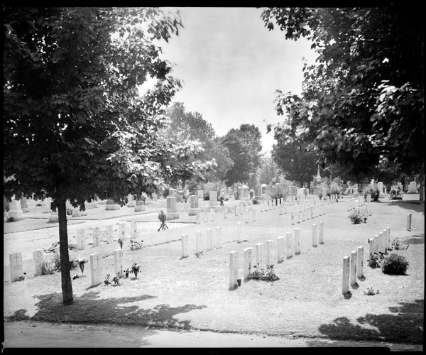
The graves of soldiers Elliott, Laming and Devereaux, killed in the South African War (e006610211).

Photo of military cemetery in Ottawa, Ontario, taken by renowned photographer Yousuf Karsh on August 13, 1934.

Colonel H.C. Osborne, war graves (e010679418_s1).

The Canadian cemetery at Bény-sur-Mer in France, where Canadian soldiers who lost their lives during D-Day and the Battle of Normandy in 1944 are buried.

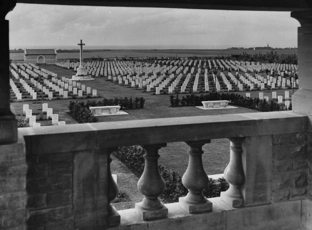
Canadian military cemetery at Bény-sur-Mer, France (e011176110).

The Canadian cemetery in Agira, Italy, where Canadian soldiers who died during the Sicily campaign in 1943 are buried.

Canadian cemetery in Agira, Sicily (e010786150).

War cemetery in Japan, where Canadian soldiers who were killed during the Korean War (1950–53) are buried.

Mrs. Renwick lays a wreath on behalf of Canadian mothers and wives on Remembrance Day in Japan (a133383).

Have you ever wondered why so many Canadian families allowed for the final resting place of their loved ones to be where they fell in combat?

Quite simply, because it was the only option—at least, initially.

To understand, we must delve into the context of the First World War, the first mass industrial war. The technological and military advances of the modern era caused skyrocketing mortality rates. As a result, the British Empire had to manage the rapid recruitment of reinforcements in addition to the thousands of deaths in a war where the repatriation of bodies was practically impossible if not discouraged. It was dangerous to search for remains in active combat zones, and moving so many corpses could easily have led to worldwide epidemics. That said, the door remained open to changing the status quo once hostilities were over. On May 10, 1917, the Imperial War Graves Commission was created by Royal Charter, with a mandate to look into the issues of deceased soldiers and war cemeteries for the entire British Commonwealth.

Text document dated May 10, 1917, written by J.C. Ledlie, from “At the Court at Buckingham Palace, Present, The King’s Most Excellent Majesty in Council.”

War Office (United Kingdom) – Imperial War Graves Commission – Charter (MIKAN 1825922).

There was no consensus among families regarding the question of cemeteries being maintained in perpetuity. Lively debates about the war graves issue took place in many parliamentary institutions. Speakers appealed to the humanity and compassion of politicians, so that the families of fallen soldiers could bring home the bodies of their fathers, brothers, husbands or sons, and in some cases, their sisters and daughters. However, no petition could change the verdict issued by the Imperial War Graves Commission:

Two-page text document explaining that the repatriation of soldiers’ bodies is not permitted.

War Office (United Kingdom) – Imperial War Graves Commission – Refusal to permit removal of bodies from countries in which they are buried (MIKAN 1825922).

“To allow removal [of war dead] by a few individuals (of necessity only those who could afford the cost) would be contrary to the principle of equality of treatment; to empty some 400,000 identified graves would be a colossal work, and would be opposed to the spirit in which the Empire had gratefully accepted the offers made by the Governments of France, Belgium, Italy and Greece to provide land in perpetuity for our cemeteries and to “adopt” our dead. The Commission felt that a higher ideal than that of private burial at home is embodied in these war cemeteries in foreign lands, where those who fought and fell together, officers and men, lie together in their last resting place, facing the line they gave their lives to maintain. They felt sure (and the evidence available to them confirmed the feeling) that the dead themselves, in whom the sense of comradeship was so strong, would have preferred to lie with their comrades. These British cemeteries in foreign lands would be the symbol for future generations of the common purpose, the common devotion, the common sacrifice of all ranks in a united Empire. […]”

This decision ensured that Canadians who had died overseas during the First World War remained on those fields of honour. The cemeteries that were built in their memory can still be visited today; they are maintained by the Imperial War Graves Commission, now the Commonwealth War Graves Commission. On July 15, 1970, Canada’s policy on the repatriation of soldiers who had died overseas changed. Order in Council P.C. 1967-1894 stated that the family of a soldier killed in action on or after that date could request his or her repatriation for a funeral. The loved ones of deceased service members can now have them brought home.

Additional resources


Ariane Gauthier is a reference archivist in the Access and Services Branch at Library and Archives Canada.

The Battle of Beaumont-Hamel: commemoration and remembrance

By Ethan M. Coudenys

The Battle of the Somme began on July 1, 1916, at 7:30 a.m., but preparations for the attack took longer than expected. The advance was planned to relieve pressure on the French forces fighting at Verdun, and it was meant to take place during the last few days of June. However, because of poor weather, the attack was delayed. For the First Newfoundland Regiment (later the Royal Newfoundland Regiment), this meant lying in wait for the assault to begin. On the first day of July, at 7:20 a.m., the Hawthorn Ridge Redoubt held by the Germans was blown up, and the British attack began 10 minutes later.

Over the course of 45 minutes (between 9 and 9:45 a.m.), the Newfoundlanders sent their men over the top of the St. John’s Road trench into no man’s land. Unfortunately, due to the high casualty rates during the early phases of the attack that morning, the Newfoundlanders had to walk above the trenches, instead of benefitting from the relative safety of the communication trenches that linked the secondary line to the primary and observation lines. In this period, nearly 85 per cent of the Regiment would be killed, wounded, or missing. Of the nearly 900 Newfoundlanders in the field, only 65 would be present at roll call the following day.

The Battle of Beaumont-Hamel was the bloodiest day in Newfoundland’s history, and in the First World War as a whole. The loss of life was too much for the British Dominion of Newfoundland. It was forced to revert to colony status in the 1920s and eventually joined the Canadian Confederation in 1949. The commemoration of this battle is a moving story that deserves more attention.

Soldiers stand on hill with caribou monument, as crowd below watches in front of wall with bronze plaques.

Beaumont-Hamel dedication ceremony for the Royal Newfoundland Regiment (e010751150).

The Beaumont-Hamel Newfoundland Memorial Park, currently administered by Veterans Affairs Canada, is located at the site of the battle. Canadian student guides are there every day, sharing the story of the Newfoundlanders of the Great War who gave their lives in service to their nation. The park itself is incredibly pristine, with massive trees, magnificent gardens and an excellent visitors centre. But the landscape tells the tale of the horrific impact that the Battle of Beaumont-Hamel had on the Dominion of Newfoundland, and the terrifying reality of war for the regiment.

The memorial site itself officially opened on June 7, 1925, and it offers a setting with a sense of home for the soldiers who were killed in the battle. The park’s landscape architect, Basil Gotto, created this ambiance by including over 5,000 trees native to Newfoundland. The major memorial is the Caribou Monument, which stands more or less on the British front line. This massive bronze statue faces toward the direction of the advance by the Newfoundlanders on July 1, 1916. The caribou’s mouth is open, and it appears to be calling out to the fallen, calling them back home. The Caribou Monument is one of seven such memorials in France, Belgium, Turkey, and Newfoundland and Labrador, which mark major moments in the Royal Newfoundland Regiment’s participation in the First World War.

The caribou statue stands at the top of a massive mound. At the base of the mound is a wall with three bronze plaques. These have the names of the 823 fallen soldiers, sailors and merchant seamen who died in the war without a known resting place. The youngest of these was 14 years old at the time of his death, while the oldest was 60. These plaques, which are original to the site, have survived a second world war and several weather events. During the Second World War, in fact, the only element from the memorial park that did not survive was the bronze lions next to the 51st Highland Division monument near the rear of the park.

Caribou monument on rocky hill, covered with fog.

Beaumont-Hamel Caribou Monument, around December 2022. Image courtesy of the author, Ethan M. Coudenys.

Today, the Beaumont-Hamel Newfoundland Memorial Park is one of the most well-preserved and moving memorials to the sacrifices made during the First World War. With Canadian students providing free guided tours, and the atmosphere of the park itself, it truly demonstrates the tragedy of the Battle of Beaumont-Hamel and the unfathomable losses suffered by the Royal Newfoundland Regiment.

Additional resources


Ethan M. Coudenys is a Genealogy Consultant at Library and Archives Canada, and a former student guide at the Beaumont-Hamel Newfoundland Memorial.

Indigenous Peoples in the First World War: researching forgotten veterans

On the left of the graphic, Tatânga Mânî [Chief Walking Buffalo] [George McLean] in traditional regalia on horse. In the middle, Iggi and girl engaging in a “kunik”, a traditional greeting in Inuit culture. On the right, Maxime Marion, a Métis guide stands holding a rifle. In the background, there is a map of Upper and Lower Canada, and text from the Red River Settlement collection.By Ethan M. Coudenys

This article contains historical language and content that some may consider offensive, such as language used to refer to racial, ethnic and cultural groups. Please see our historical language advisory for more information.

Understanding the First World War from the perspective of the Indigenous Peoples of this land has been of paramount importance for many Indigenous researchers, such as myself. Dedicating hours upon hours to research a single Great War veteran is sometimes required just to identify that they were indeed Indigenous. While we have excellent resources about some of the very well-known First Nations, Inuit and Métis Nation service members from that war, there is still much to discover in this realm of historical knowledge.

This post is not meant to convey the story of the Indigenous people who served during the First World War, nor would I attempt to simply generalize the experiences of Indigenous peoples into a single blog post. Instead, I will share the stories of two very different individuals and relate how research techniques can be used to better research an Indigenous person who served in the Great War.

The story of John Shiwak

Two side-by-side photos of the same man seated and wearing an army uniform.

John Shiwak, Royal Newfoundland Regiment # 1735. The Rooms, Item E 29-45.

John Shiwak was born in 1889 in Rigolet, Labrador. A member of an Inuit community, he was an experienced hunter and trapper when he enlisted with the First (later “Royal”) Newfoundland Regiment on July 24, 1915. He was still in training when the regiment was sent over the top of the St. John’s Road trench at Beaumont-Hamel on July 1, 1916, the first day of the Battle of the Somme. When Shiwak joined the regiment in France a few weeks later, on July 24, he was one of many who saw the aftermath of the near destruction of the regiment in the 45 minutes that they fought on the Somme battlefield. In April 1917, Shiwak was promoted to lance corporal. Unfortunately, that November, less than a year before the guns fell silent, Lance Corporal John Shiwak met a sad end. In the middle of the battle for Masnières (during the larger First Battle of Cambrai), Shiwak’s unit was struck by a shell, killing him and six others.

Group of five men standing or sitting.

Members of the Legion of Frontiersmen (before 1915); John Shiwak is standing at the left. The Rooms, Item IGA 10-25.

This story is not uncommon in accounts of the First World War. The Inuk man was killed in the line of duty, in the midst of his brothers in arms. Yet his story is even sadder: until now, the gravesite of Shiwak and those six other brave men were never located. It is theorized that a school was built above the grave, the construction happening without the knowledge that seven soldiers of the Great War were buried there. Nevertheless, as with all casualties without a known resting place, Shiwak is commemorated. His name is forever etched on the bronze plaques at the Beaumont-Hamel Newfoundland Memorial in France, and at a similar memorial in St. John’s, Newfoundland and Labrador.

The story of Angus Edwardson

The story of Private Angus Edwardson is of personal interest to me. He was my great-great-grandfather and fought at Passchendaele. He was born in 1894 in the northern, primarily Algonquin Anishinaabe, community of Lac-Barrière, about 300 kilometres northwest of Ottawa. On his enlistment form, Edwardson stated that he and his family resided in Oskélanéo, Quebec. For a very long time, our family did not know that he was Indigenous, nor did we know about his time in the trenches in any detail.

Luckily, in my line of work, one can discover some very interesting pieces of information. During a search through the 1921 Census, I found information that he was an “ancien soldat” (veteran); I was therefore able to find his attestation papers. While Edwardson’s story is much less noteworthy than that of Shiwak, his story provides an insight into the challenges of researching Indigenous men who fought in the Canadian Expeditionary Force (CEF) and indeed in the British forces as a whole.

Two pages of the attestation papers of Angus Edwardson.

Attestation papers of Angus Edwardson (regimental number 1090307).

In the physical description of Edwardson, the enlistment officer wrote that his complexion was “fair,” his eyes “blue,” and his hair “dark.” This description does not reflect the racial idea of an Indigenous person, nor did the enlistment officer note that Edwardson was First Nations by writing the commonly used term “Indian” under the section of the form entitled “Distinctive marks, and marks indicating congenital peculiarities or previous disease.”

From what we can see in his records, Edwardson was a member of the 253rd (Queens’ University) Highland Battalion, though he served with a number of other battalions and regiments during his time on the front. Notably, while serving with the 213th Battalion on August 28, 1918, he was wounded in the left hand by a bullet.

Challenges facing researchers

As I mentioned, not knowing that a member of the CEF was Indigenous is a major sticking point for researchers. The attestation files may not contain this information at all. In fact, this is very common in the later years of the First World War. Neither of the two men that I have written about have the telltale designation “Indian” on their attestation forms. The only way we can know for certain that these two men were indeed Indigenous is by relying on additional sources.

The first of such sources is the often-overlooked census records. The census provides vital information about research subjects, and individual information can greatly increase success in researching Indigenous members of the CEF and the Royal Newfoundland Regiment (RNR). In the case of Edwardson, I discovered that he was in fact Indigenous by looking at his record in the 1921 Census. For Shiwak, there was an entirely different route to finding his identity, which was incredibly difficult. I uncovered information about Shiwak’s ethnic heritage through the memoirs of Sydney Frost, a captain with the RNR, entitled A Blue Puttee at War. This memoir, however, is not the only way to find out that Shiwak was Indigenous.

List of names, ages and genders from the 1921 Census.

Census entry for Angus Edwardson and family, 1921 (e003065155).

Secondary sources about the First World War are numerous. For Shiwak, several appear when simply searching his name, but for other, lesser-known Indigenous members of the CEF, this may be more difficult. The excellent book For King and Kanata: Canadian Indians and the First World War by Timothy Winegard shows how we may be able to improve search techniques for Indigenous individuals and groups that served in the CEF. Though not explicitly, Winegard indicates the role of individual communities and their part in deciding to send men to enlist for the war effort. That said, this effort can be difficult, and it is worth reaching out to local genealogical societies and/or Indigenous communities for help in locating a list of names or simply an idea of how many men served from that community.

The final source of information that is quite useful in these cases is the so-called Indian Registers. These are archival documents with lists of names of members of bands. While the registers are a great resource for those researching members of a specific First Nations band and who are able to visit Library and Archives Canada in Ottawa, there are challenges remaining for those who do not know the band of their research subject or whether their subject died during the war. For individuals researching an Inuk or a member of a Métis Nation community, the challenges deepen, as there is very little primary source material from the period immediately after the Great War. It may be possible to identify Inuit or Métis Nation members of the CEF or RNR through secondary sources, but this can be challenging and take time.

Conclusion

Lance Corporal John Shiwak and Private Angus Edwardson both fought during the First World War. The former was Inuk and the latter was First Nations. The two cases exemplify the many challenges that face researchers when they are looking to find information about members of the CEF or RNR who were Indigenous. These challenges are multi-faceted, and they can pose significant difficulties in research into the stories of Indigenous veterans who fought in the Great War. There are some solutions and resources, including consulting archival records (census records specifically), checking with local Indigenous communities, and accessing some resources specific to Indigenous Peoples at Library and Archives Canada. Nevertheless, these proposed solutions can only go so far in helping researchers find information about Indigenous people who served in the First World War.

Additional resources 


Ethan M. Coudenys is a Genealogy Consultant at Library and Archives Canada. They are proudly of Innu heritage and the descendant of a residential school survivor.

A pumpkin pie from 1840

Version française

Cooking with Library and Archives Canada banner

By Ariane Gauthier

La cuisinière canadienne, published in 1840, is one of the first cookbooks—perhaps even the very first—written and published in Canada. Its author wrote it for both professional cooks and the general public. This book marks the beginning of French-Canadian cuisine as such. In terms of style and content, it is intended to be efficient, seeking to encourage “wise home economics […] suited to the budgets of Canadian families.”

This book is available online (in French only) through Library and Archives Canada’s Aurora catalogue (OCLC 1140071596). Simply click on the “Access Online” button on the right side of the page in the “Retrieval Options” box.

The title page of La cuisinière canadienne (OCLC 1140071596).

To accompany the book, I found Yannick Portebois’s review of La cuisinière canadienne (which can be read for free on Érudit, in French only) very useful. It helps modern readers understand the measurements used at the time and the technical language that is no longer used today. It also presents the historical context in which this book was written. It was a key moment for the formation of Quebec’s cultural identity, with one foot in its French past and the other in the new reality of an ever-growing Anglophone population. Yannick Portebois noted the francization of certain English words and the use of bourgeois terms that would mark the vocabulary of Quebec’s emerging cuisine.

The challenge

As an amateur cook, I decided to take on the challenge of cooking a vintage recipe proposed in this book.

The first thing to understand is that recipes of the past, especially those that date back to the mid-19th century, are not written as they are in books today. There is no complete list of ingredients, quantities are approximate and recipes are presented in essay form. La cuisinière canadienne provides alternative ingredients, as needed. The goal was not to create recipes like the ones readers of today want, but to communicate the basic principles so that cooks can manage on their own. In a way, La cuisinière canadienne determines the destination, but it is up to us to choose how to get there—that is, the ingredients, quantities and technique.

Three pages of La cuisinière canadienne explaining certain cooking terms.

The pages of La cuisinière canadienne that were most helpful to me in preparing my recipe (OCLC 1140071596).

My first challenge was to write the recipe, because La cuisinière canadienne does not provide a complete recipe for pumpkin pie. Chapter X contains a recipe for pie dough (or shortcrust pastry) with only the vague indication of adding the jam of our choice to bake a pie.

To do so, it was necessary to read chapter XI on jams. Originally, I was hoping to make a good sugar pie, but La cuisinière canadienne does not provide any recipe for cream sugar or maple filling. So I settled for a pumpkin pie, which I thought was a good substitute.

Almond milk, squash, oranges, butter, flour, maple syrup, measuring cup, pie plate and rolling pin.

Ingredients and materials used by the author to make the pumpkin pie from La cuisinière canadienne. Credit: Ariane Gauthier.

Once the recipe was written, the ingredients had to be gathered. The pie dough required flour, butter (melted) and milk (hot). La cuisinière canadienne says to mix everything until a dough is formed. Given the lack of more specific information, I relied on my existing knowledge. In recipes that I’ve followed before, the pie dough was very dry. Therefore, I added flour to a cup of melted butter and a cup of hot milk until I had a dry dough.

I confess that I did not measure the quantity. The idea is that the dough should barely hold together.

Then, I worked the dough so that everything was fully incorporated. I laminated it—that is, flattened it with a rolling pin before folding it on itself—and I repeated this over and over again until the dough became smooth and uniform. After that, I delicately placed the dough in a pie plate and cut off the excess. Usually, the dough should be perforated to make sure it does not inflate and baked a little to prevent the filling from soaking it. That is what I did before baking it for five minutes at 350°F.

Maple syrup, diced squash and orange peels in a pot on the stove.

Combining ingredients for pumpkin jam. Pumpkin cubes are boiled in syrup with orange peel for three hours. Credit: Ariane Gauthier.

In the meantime, I followed La cuisinière canadienne’s instructions for pumpkin jam. Basically, I had to stew pumpkin in an equal amount of syrup (or molasses) for three hours. I could also add orange or lemon peel to enhance the taste. Unfortunately, because it was not pumpkin pie season, I had to settle for a butternut squash. I chose maple syrup because it was the affordable option for cooks of the time. It was only after 1885 and the passage of the Tariff Act that maple syrup became a luxury product, with the price of cane sugar suddenly falling. In subsequent years, laws and measures protecting the maple products industry and the purity and quality also affected the price of syrup.

Due to the technological advances that have taken place since the publication of La cuisinière canadienne, I only had to wait about an hour and a half before the butternut squash was tender. I blended everything to obtain a more uniform jam, keeping the orange peel for taste. It was for better or worse, depending on taste, because this choice made the pie taste more of orange than anything else. Warning for the intrepid bakers who will try to cook their own pumpkin pie from 1840: it may be better to remove the peels!

Three photographs showing the pie being put together: the dish with the dough only, the filling being poured onto the dough and the final dish before cooking.

Putting the pie together. Once the dough has been pre-cooked for a few minutes, the pumpkin jam is added, and the whole thing is put back in the oven to finish cooking. Credit: Ariane Gauthier.

Finally, I poured the jam onto the dough and baked the pie, still at 350°F. To determine when the dough was baked, I relied on my nose and my eyes. Here is the final result. What do you think?

Photograph of the pie fresh out of the oven. Leaves, a feather, a book and the words BAC and LAC in dough are placed on the top of the pie.

The pie after it finished baking. After it visited Reference Services the next day, not a crumb was left. Credit: Ariane Gauthier.

My colleagues obviously loved it, especially my supervisor, who ate three slices. This recipe, although very different from our contemporary recipes, still seems to be appreciated!

The New Galt Cook Book – 1898

Cover page with the title The New Galt Cook Book and an illustration of a woman with an apron holding a dish containing food.

Cover page of the cookbook The New Galt Cook Book (OCLC 1049883924).

Although I have discussed a recipe from La cuisinière canadienne, its Canadian English equivalent is also noteworthy. The New Galt Cook Book was essential in English-Canadian kitchens. This is a new edition of a popular book, especially around Galt, in southwestern Ontario. The publishers said that copies of the book were sent to China, Egypt, India, South Africa, Australia and the United States. Like many old cookbooks, this book includes recipes, suggestions for simplifying household work and a list of remedies for common diseases.

If you try your luck with the pumpkin pie from 1840 or any other recipe from La cuisinière canadienne, please share your results on Library and Archives Canada’s social media accounts: Facebook, Instagram, X (Twitter), YouTube, Flickr or LinkedIn, using the hashtag #CookingWithLAC and tagging our social media.

Other Library and Archives Canada resources


Ariane Gauthier is a Reference Archivist in the Access and Services Branch at Library and Archives Canada.

Vimy Ridge: a journey of maps (part 2)

By Ethan M. Coudenys

Picture the scene of the moments leading up to a massive military advance. On the morning of April 9, 1917, a cold rain falls on the Douai plain in France. To the west, a great number of Canadians have gathered to begin their attack on Vimy Ridge at precisely 5:30 a.m. Of the approximately 30,000 men preparing to advance that day, roughly a third are hidden underground in tunnels built specifically to hide them from the German forces’ lookouts. At the moment of attack, the men burst from the tunnels and shower brimstone and hellfire on the forces that oppose their advance.

A tunnel at Vimy Ridge.

Grange Subway under Vimy Ridge, August 17, 2022. Image courtesy of the author, Ethan M. Coudenys.

These tunnels were mainly constructed by the Welsh Companies of the Royal Engineers. The Welsh miners were mostly professional miners, and they would cut through the chalk stone 10 to 15 metres below the battlefield in near-total darkness. Some 10 kilometres of underground tunnels ran from the furthest Canadian rear trench to the front of the line. They were used to move supplies, run messages and conceal the advancing army on the day of the attack.

Speaking from my experience as a tour guide at the Canadian National Vimy Memorial at Vimy Ridge, these tunnels, often filled with water, bats, rats and unusual smells (probably far worse back then), were incredibly confusing to traverse during the First World War. There were electric lights every 20 metres or so, but the tunnels were dark, twisting and loud. Chalk conducts sound, so soldiers could hear, not only every shell falling on the surface with some clarity, but also miners digging away and the few soldiers and officers shuffling through the tunnels.

To avoid confusion, maps were created to prevent messengers and officers from getting lost in the subterranean labyrinth. Only one of these tunnels, the Grange Subway, is currently open to visitors at the Vimy Ridge National Historic Site. The Durand Group, a research and exploration association, is carrying out the dangerous work of investigating and uncovering tunnels and redoubts, but these efforts have not yet resulted in additional tunnels being opened to the general public. Nevertheless, the Durand Group’s work provides insights into what the maps of different tunnels were like at this time in the war, as the association maps and reports on newly uncovered tunnel systems in France and Belgium.

The attack on Vimy Ridge consisted of two different phases. The first, and most famous, is the taking of the ridge along the 12-kilometre-long front line for which the Canadian Expeditionary Force (CEF) was responsible. The CEF had four main objectives, but Hill 145, the highest part of the ridge, was the declared central target for the operation. The second phase was taking the Pimple (also known as Hill 119). This was a heavily fortified and well-manned artillery and heavy machine gun post at the top of a hill. It was very easy to defend, and very useful if the German forces wanted to regain territory lost in the first phase. Thus, the second phase of the Battle of Vimy Ridge is now known as the Battle of Hill 119 (or the Pimple).

Map showing artillery plan, including smoke screens.

Artillery barrage plan – Battle of Hill 119 (or the Pimple) (MIKAN 3946966). Photo: Ethan M. Coudenys.

Mapping the artillery attack

The Vimy Ridge and Pimple attacks were Canada’s contribution to the larger military operation of the Battle of Arras, which took place along a 30-kilometre front led by mostly British forces. One of the most important elements of the attacks was the efforts of the artillery brigades, for which both Canadian and British artillery units worked in tandem to aid the advance of the infantry troops. This effort required immense preparedness and incredible tenacity. It was critical for artillery units to follow the same schedule, to ensure that the barrage of artillery shells would advance at a very specific pace of 100 metres every three minutes. Every unit was therefore issued maps and specific timings on each of the changes in range, as well as the speed of firing. This tactic was called a rolling (or creeping) barrage.

To expand on the discussion in part 1 of this post, a rolling barrage is a military tactic largely developed by British and Canadian generals who had witnessed the failure of artillery support at the Battle of the Somme in France (July–mid-November 1916). The rolling barrage tactic involved firing a wall of shells into no man’s land and advancing the wall slowly, so that the opposing forces could not exit their shelters to mount an effective defence before the infantry troops reached their line. This tactic was effective in eliminating defensive enemy snipers and machine guns during the start of the Vimy Ridge battle. Canadian writer Pierre Berton states in his work on Vimy Ridge that the roar of the artillery firing was so loud that it could be heard as far away as London. To the soldiers advancing into dangerous territory, it seemed as though the sky was made of lead, because of the sheer number of shells flying overhead.

Let us now turn to the various maps of the artillery on Vimy Ridge. For the assault on Hill 145, it was important for the infantry and artillery to be synchronized. The artillery commanders received the same maps as the infantry units so they could measure the advances of the various divisions and brigades, sometimes kilometres away.

More importantly, the artillery officers received maps of specially chosen target areas, to help them destroy major defensive installations before the infantry came into range of those positions. These target areas could be machine-gun nests, sniper posts, defensive artillery pieces or mortar emplacements. Part of the plan of attack was to ensure that there was a significant time gap between the first and second advance. For example, the distance between a red line and a black line would be roughly a 30-minute interval, during which the secondary wave of infantry and supporting troops could move up. In other words, the artillery would fire on specific targets for a set amount of time, wait 30 minutes to allow the infantry to advance, then fire on more distant targets. This allowed for the infantry to rest and fortify their newly taken positions, while the artillery targeted the potentially dangerous defensive fortifications further along the front.

To capture the Pimple, the strategy was quite different. While the artillery continued to use the rolling barrage, they also used two new tactics that were introduced and developed during the Great War. The first was creating what some scholars have called a “killing field,” where, through heavy artillery fire, defending troops are forced to leave their shelter for open space and then are targeted by machine guns and artillery. The second was the launching of smoke screens. The artillery would launch barrels of burning oil into the battlefield, creating a thick, black cloud of smoke to hide the advancing infantry. These two tactics would become a trademark approach of the Canadians in later battles, including the Battle of Hill 70 in Lens, France (August 15–25, 1917) and the Third Battle of Ypres (Passchendaele) in Belgium (July 31–November 10, 1917).

While the rolling barrage was successful in the preliminary attacks on Hill 145, the capture of the Pimple was one of the most costly battles in Canadian military history, with over 10,000 men killed, injured or missing.

Conclusion

The mapping of a battlefield is not a new concept. From the age of the Roman Empire to the Napoleonic Wars, generals and warlords have used maps to plan attacks and navigate battlefields. However, the development and production of these maps was usually done exclusively for high-ranking officers and non-commissioned members. At the Battle of Vimy Ridge, to ensure better overall preparedness among troops and to prevent confusion among infantry soldiers, maps of the battlefield were produced and distributed widely, so that even low-ranking lieutenants and lance-corporals would have access to the plan of attack. This innovation in how the allies fought during the First World War resulted in a hugely successful attack upon the German forces’ position on Hill 145 (Vimy Ridge) and Hill 119 (the Pimple) during the Battle of Vimy Ridge, part of the greater Battle of Arras. Maps illustrated clear and focused goals for individual units, and they demonstrated the tactics that the soldiers, artillery and support services would use to take the ridge. These maps followed many months of preparations for the Vimy Ridge battle; they were a major contributing factor in the CEF’s successful capture of Hill 145.

Additional resources


Ethan M. Coudenys is a Genealogy Consultant at Library and Archives Canada.

Bilingual census data: a better search experience for all Canadians

Web banner for The 1931 Census series. On the right, typed text: "The 1931 Census". On the left, moving train going by a train station.By Julia Barkhouse

This article contains historical language and content that some may consider offensive, such as language used to refer to gender, racial, ethnic and cultural groups. Please see our historical language advisory for more information.

Library and Archives Canada (LAC) is the guardian of Canada’s distant past and recent history. It holds the historical census returns for Canada, including some dating back to New France and some for Newfoundland. We have indexed some dating from 1825 to 1926, and these are available online through Census Search.

Before Confederation, censuses were generally collected in either English or French, depending on the location. The Dominion Bureau of Statistics (now Statistics Canada) phased in bilingual forms after Confederation in 1867.

Example of a bilingual Census 1921 form enumerated in English and French:

A census-taking sheet from Census 1921. This particular image is page 6 for the sub-district of Scots Bay in Kings District, Nova Scotia.

Census 1921 form enumerated in English (e002910991).

A census-taking sheet from Census 1921. This particular image is page 19 for the sub-district of Wolfestown (Township) in Richmond-Wolfe District, Quebec.

Census 1921 form enumerated in French (e003096782).

The language used to record answers to census questions may reflect the language preference of the enumerator or the language in which the answers were provided. The historical census data that we have reflects our linguistic duality as a nation. Census returns from Quebec and some parts of New Brunswick and Manitoba are written (or, enumerated) in French, while the rest of Canada was enumerated in English.

When our partners, including Ancestry and FamilySearch, indexed the censuses from 1825 to 1926, we produced a wealth of data with names of individuals, their gender, marital status, etc. However, we were faced with a serious challenge: census data could be collected in either English or French depending on the personal preference of the enumerator. So how did we handle this?

Life as an Enumerator

Let us detour for a moment and describe the journey of the enumerator. Enumerators were Canadians hired by the Dominion Bureau of Statistics to collect census data in one or more sub-districts. They received a book of instructions (such as this one for Census 1921) that detailed what they were supposed to write on the form depending on what people answered. They were given a booklet of census return forms and instructions on which sub-districts to enumerate. Then this person had a timeframe to enumerate a number of sub-districts and mail these forms back to the government department. You can imagine this person going from door to door in a horse-drawn carriage or perhaps an early automobile (maybe a Ford Model T) by 1921.

The enumerator knocked on the door and asked to speak to the head of the household (typically the father and/or husband). They might be invited in to sit at the kitchen table as they asked questions. If the family was not home, there might be a notice or calling card left on the door with contact details to follow up and meet the enumerator by a given date to be counted in the census.

Depending on the province in Canada, the enumerator either wrote down information in the language of the person speaking or in their personal language preference. Therefore, it is possible that French regions of Canada around Quebec, New Brunswick and Manitoba were enumerated in one or both languages depending on the enumerator’s personal preference.

Fast forward: the data captured on the forms was transcribed by our partners around 92 years after the census taking and put online.

Language Barriers

When LAC put these databases online, we noticed that we had data in both languages. If you wish to search for your ancestor, you have to search in the language of the enumerator. Did the enumerator write your grandmother’s information in English or French? Does your name have an accent (é, è …) that might have been misheard (or not captured) by the enumerator? Does your uncle’s name have a silent “h” that might have been omitted? This creates a language barrier for our researchers, who want to find people but do not speak the language used at the time. Some of our Francophone researchers have to search in English to find their French-speaking ancestors. This is an unbalanced search experience for Canadians who access our Census Search interface in French.

Creation of Census Search

When the Digital Access Agile Team reorganized and consolidated the 17 census databases into Census Search last November, we wanted to deliver a better search experience for all Canadians. Our aim was to provide the same search experience for Francophones as for Anglophones, so that any of our clients who use the French Census Search interface can search and get the same results as if they were searching in English.

So how do you do this? How do you translate information like gender, marital status, ethnic origin and occupation for over 44 million individuals to offer an equal experience for all Canadians? It’s actually very simple. The solution? Data cleanup.

A Peek Under the Hood

Let’s go behind the scenes for a moment to look at how census data is saved. Census Search is the public interface that LAC clients can use to search. The census data for each individual in Census Search is saved in one master table called EnumAll.

Census data saved in a table in SQL Management Server.

Screenshot of Census.EnumAll from SQL Management Server (Library and Archives Canada).

In this table, each line represents an individual person. The data captured about that person is separated into columns. If we do not have data in a particular column, it says NULL.

Creation of Common Data Pools

Census.EnumAll acts as the master data table. From this, we created common data groups (or, pools). What do I mean by this? We copied all of the data for one of the columns (Gender, Marital Status, Ethnic Origin, Religion, etc.) into a separate table. The only information in this separate table is a list of Genders or options for Marital Status, etc. We call this a common data pool, meaning that all the data in this table (or, pool) relates to one piece of information.

The common data table separates the data (e.g., “Male” or “Female”) from the individual person. If you look at 44 million individuals, you see the same data repeated, such as the number of times the enumerator wrote “Male” or “Married.” In a common table, you see “Male” only once, with a value count for the number of people with this information (which we call an attribute).

This is where the magic happens.

The Gender table in the back end of Census Search. Of note, there are variances (Male and M, Female and F) and two columns titled TextLongEn (English display) and TextLongFr (French display).

Screenshot of T_Gender from SQL Management Server (Library and Archives Canada).

As you can see in this separate common data table, we can do more things. With codes, we establish one way to write each Gender (in this example). This is called an authority. We then perform cleanup so all the variants point to this one authority. In the screenshot above, you’ll notice a variance between “Male” and “M.”

Once we have this authority, we create columns for how we want to display the information in Census Search. We create an English (TextLongEn) and a French (TextLongFr) display. We then add the bilingual translation once and it applies to everything. In this case, we translated “Male” to “Homme,” and it applies to all 20,163,488 people who identified as “Male” across 17 censuses.

We then put all the tables back together and index the records to display in Census Search. So depending on the language of your choice, the interface and the data itself will now translate for you.

English Census Search interface showing Gender drop-down with values for Female, Male and Unknown alongside the French Census Search interface showing the same drop-down with Gender values for Femme, Homme and Inconnu.

Screenshots of Census Search in English and French (Library and Archives Canada).

Now, when I search for my great-grandfather, Henry D. Barkhouse, and display any of his census entries, the data translates as well.

Two screenshots, one in English and one in French, of a Census 1911 record for Henry D. Barkhouse, with arrows pointing out where the data translates.

English and French display of Census 1911 record for Henry D. Barkhouse (e001973146).

Progress Check-in

As you can imagine, this work takes time as we diligently clean up and translate our data. Our first priority was to create drop-down menus on Census Search for Gender and Marital Status. Now, if you wish to search by either of these fields, you will see a short list of terms that are translated and available in both official languages. As we continue this work, our next priorities are Ethnic Origin and Place of Birth. We are about 60–70% finished with these two, and our clients should see new options coming to Census Search in 2024. After these two priority fields, we will continue to translate other fields like Religion, Relationship to head of household, Occupation, etc.

Conclusion

Consolidating all 17 censuses into one platform, Census Search, gave us the opportunity to create a bilingual display for our census data by cleaning up the data. Since its launch, our platform delivers a more equal search experience in the language of your choice. I encourage you to try it out and tell us if your search experience has improved.

As always, we love to read your feedback and ideas via our email or you can sign up for a 10-minute feedback session with us.


Julia Barkhouse has worked at Library and Archives Canada in data quality, database management and administration for the last 14 years. She is currently the Collections Data Analyst on the Digital Access Agile Team.

Vimy Ridge: a journey of maps (part 1)

By Ethan M. Coudenys

Cartography is the practice of drawing or making maps; during the First World War, this was vital for planning and preparing attacks and defensive actions. Battles in France like those of the Marne, Somme and Verdun were mostly planned with large maps by high-ranking officers and non-commissioned members. However, for the battle at Hill 145—better known as Vimy Ridge—cartography played an integral role in the planning of the assault by the Canadian Expeditionary Force (CEF).

Group of men going through barbed wire with shells exploding in the background.

Canadians advancing through German wire entanglements, Vimy Ridge, April 1917 (a001087).

Before we begin, we should set the scene by talking about the CEF before the Battle of Vimy Ridge. The Canadians had fought in various battlefields in France and Belgium, including with distinction at Flers-Courcelette (August–November 1916) in France, about 50 kilometres from Vimy. Under the command of Lieutenant-General (later Field Marshal and Governor General) Sir Julian Byng, the CEF had become a very successful fighting force. In November 1916, the Canadians began moving to the east of the French town of Arras. There, they began preparing for an attack on Hill 145, where the German forces had taken nearly three years to build very heavily fortified lines of trenches.

The Battle of Vimy Ridge, which began on April 9, 1917, was not an isolated operation; it was a small part of the Battle of Arras. The two major points of the battle for the ridge, for which the Canadians were responsible, were the ridge itself (Hill 145) and the Pimple (Hill 119). Incredible preparations went into planning this attack.

Between the beginning of the war in 1914 and when the Canadians took up positions in late November 1916, French and Moroccan divisions had tried to take Vimy Ridge. They advanced the allied front line closer to the ridge. During the Battle of Verdun, the British took over these positions, and they expanded and strengthened the relatively weak fortifications. By November 1916, the CEF entered the front line at Vimy with very good fortifications.

Map showing a tunnel-and-crater system.

Map 1 – Map of La Folie battlefield: group of tunnels, near Vimy. Courtesy of Veterans Affairs Canada – European Operations.

The Canadians were called to the line at Vimy for the first time as an entire corps, fighting side by side. This was incredibly important not only for the soldiers but also for the young nation. For many, it signified the start of a process whereby Canadians would collectively build their cultural and national identity.

We can better understand the importance of cartography in battle by first reviewing some of the maps that are presented today at the Visitor Education Centre in the Canadian National Vimy Memorial in France. There, Canadian guides—all university and college students—educate the public about the Battle of Vimy Ridge, including the tunnels that were built to support the advance of Canadian troops in April 1917. In maps 1 and 2, the different tunnels and trench lines used during the battle for the ridge are shown.

Map showing the battlefield during the Battle of Vimy Ridge.

Map 2 – Battlefield map of the Battle of Vimy Ridge: modern map. Courtesy of Veterans Affairs Canada – European Operations.

How were the maps made?

Maps were important for infantry soldiers because they helped to ground and situate them in an environment marked by constant fear, confusion and proximity of death. During the months leading up to the Vimy Ridge battle, soldiers were sent into the German forces’ trenches to gain information about the enemy’s fortifications and weapon emplacements that lined the front. Moreover, the Royal Flying Corps (later the Royal Air Force) used aerial photography to pinpoint areas of fortifications and map points of interest for the attack. Let us examine this gathering of information by soldiers.

The CEF collected information by sending small incursions into the German lines, with soldiers memorizing the layouts of the other side’s trench systems. These could be completed by a small group of men or a very large group (5,000 or more in one instance) and took place from November 1916 until the eve of the battle in April 1917.

During the infamous trench raids, Canadian soldiers would be tasked with memorizing the layout of the trenches and important locations in the German forces’ lines. These vital recollections were later reflected in detailed maps, which were used by the Canadians to help reduce confusion among the infantry. The trench raids could be incredibly dangerous, both for the men raiding and for the defenders. Often these attacks would take place at night, and both attackers and defenders could suffer heavy losses.

Hand-drawn map of German trenches after a raid before the Battle of Vimy Ridge.

Hand-drawn map of German forces’ trenches after a raid, Vimy Ridge, 1917 (MIKAN 4289412). Photo: Ethan M. Coudenys.

The maps that were created as a result of these raids, such as the example above, were often drawn by hand, from memory, by individual soldiers.

What maps were made?

Map showing artillery barrage in the Vimy region in France.

Artillery barrage map, 1st Field Survey Company, Royal Engineers, near Vimy, 1917 (e000000540).

We are very fortunate to have access to a vast number of maps from the Great War in the collection at Library and Archives Canada. Some of the most frequently requested by researchers are the trench line maps of the Western Front. As mentioned above, these maps were drawn through painstaking and sometimes bloody collection of information by soldiers, engineers and pilots. These maps were issued widely to both low-ranking officers and non-commissioned members of the infantry to help them succeed in the attack on April 9, 1917.

The first map issued, and perhaps the most important for the advance, was the barrage map. During the attack on Vimy Ridge, the Canadian artillery, supported by numerous British field artillery units, used the tactic of a rolling (or creeping) barrage to subdue resistance by the German forces while the infantry advanced behind a wall of falling shells. This process was incredibly well timed, and it needed to be, to avoid any friendly fire casualties. Thus, maps were created and used by the artillery units to launch this barrage on the German forces’ lines. These maps detail the targets of the artillery leading up to the four main objectives of the CEF between April 9 and 12, 1917. They show the 100-metre advances of the rolling barrage every three minutes, allowing the infantry units following the barrage to successfully move behind the wall of fire. The maps also show the various targets of particular interest, including fortifications, machine gun emplacements, mortar emplacements and munitions storage areas.

Cardboard map detailing the Western Front at Vimy Ridge.

Infantry soldier’s pocket map, made of cardboard, Vimy Ridge, 1917 (MIKAN 4289412). Photo: Ethan M. Coudenys.

The most widely used maps in the attack on Vimy Ridge were those issued to infantry units. These maps were small copies of larger planning maps used by high-ranking officers, but they included the individual objectives of each platoon and company. This was an incredibly important step in planning and executing the attack on the ridge. Despite the confusion caused by gun and rifle fire, the maps helped the advancing soldiers to stay on course.

The change of policy allowing soldiers to carry their own battlefield maps might seem like a minor one, but it had a significant effect on the CEF’s success in the Battle of Vimy Ridge.

 Additional resources

  • The Underground War: Vimy Ridge to Arras by Phillip Robinson and Nigel Cave (OCLC 752679022)
  • Vimy by Pierre Berton (OCLC 15063735)
  • Vimy 1917: Canadians and the Underground War by Dominique Faivre (OCLC 1055811207)

Ethan M. Coudenys is a Genealogy Consultant at Library and Archives Canada.

Pidji-ijashig – Anamikàge – Pee-piihtikweek – Tunngasugit – ᑐᙵᓱᒋᑦ – Welcome

On the left, Tatânga Mânî [Chief Walking Buffalo] [George McLean] is in his traditional First Nation regalia on a horse. In the centre, Iggi and a girl engage in a “kunik,” a traditional greeting in Inuit culture. On the right, Maxime Marion, a Métis guide, holds a rifle. In the background, there is a map of Upper and Lower Canada, and text from the Red River Settlement collection.

This blog is part of our Nations to Nations: Indigenous Voices at Library and Archives Canada series.

By Karyne Holmes

This article contains historical language and content that some may consider offensive, such as language used to refer to racial, ethnic and cultural groups. Please see our historical language advisory for more information.

Nations to Nations: Indigenous Voices at Library and Archives Canada is a multilingual and interactive e-book that features hundreds of items in the care of Library and Archives Canada (LAC) through the perspectives of First Nations, Inuit and Métis Nation staff. The first stages of developing the e-book began in 2018, shortly after I had joined LAC as a researcher for We Are Here: Sharing Stories (WAHSS), LAC’s initiative in researching, digitizing and describing Indigenous-related records to make them more accessible. I was honoured to be invited as one of the co-authors for the e-book and have the task of writing the e-book’s introductory text, “Pidji-ijashig – Anamikàge – Pee-piihtikweek – Tunngasugit – ᑐᙵᓱᒋᑦ – Welcome.” In writing the introduction, I reflected on how finding historical family documents has been personally significant and why the research and access work of WAHSS is so meaningful. I wanted to communicate the value behind projects like the e-book and WAHSS. The introductory message also highlights how the e-book celebrates language knowledge and language reclamation.

Black-and-white photograph of two women and a girl standing outdoors in front of a stretched moosehide laced onto a wooden frame. The girl is carrying an infant, and the woman on the left is holding the hand of a small child. They are on grassy vegetation, and there is a row of tall deciduous trees without leaves in the background.

Dëne Sųłiné women and children standing in front of a moosehide tanning frame, Christina Lake, Alberta, 1918 (a017946). This photo is featured in “Traditional Caribou and Moosehide Tanning in Northern Dene Communities” by Angela Code.

The Steering Committee on Canada’s Archives recently released a Reconciliation Framework as a response to Call to Action 70 issued by the Truth and Reconciliation Commission of Canada. The report acknowledges that the “colonial archival record has significantly contributed to the formation of a Canadian historical narrative that privileges the accomplishments of Eurocentric settler society at the expense of First Nations, Inuit, and Métis identities, experiences, and histories.” A fundamental message of the framework is that archives must respect Indigenous peoples’ intellectual sovereignty over materials created by or about them, and they must integrate Indigenous perspectives, knowledge, languages, histories, place names and interpretations into Indigenous-related archives.

The framework outlines ways that we can incorporate reconciliation into archival practices that reflect the work that has started at LAC. Our collaborative Nations to Nations publication is a valuable educational resource that shows the importance of re-contextualizing archival records to bring awareness to the diversity within First Nations, Inuit and Métis Nation perspectives and lived experiences.

“Pidji-ijashig – Anamikàge – Pee-piihtikweek – Tunngasugit – ᑐᙵᓱᒋᑦ – Welcome” in Nations to Nations: Indigenous Voices at Library and Archives Canada

To read the following text in Anishinabemowin, see the e-book. Nations to Nations: Indigenous Voices at Library and Archives Canada is free of charge and can be downloaded from Apple Books (iBooks format) or from LAC’s website (EPUB format). An online version can be viewed on a desktop, tablet or mobile web browser without requiring a plug-in.

 Archives and library collections provide a glimpse into the lives and experiences of our ancestors. This is true for all people, but they have special significance to Indigenous peoples. Ongoing colonial policies and actions have separated our families, thus cutting our connections and access to culture, community, knowledge and stories. Archival records and publications can facilitate the discovery of family and community history. They can also ignite memories and restore knowledge. For many, these have been partially lost through the residential school era and the ongoing forced removal of Indigenous children from their families. Historical records can recover missing pieces and unearth new information about our personal and community histories. They can allow us to share our stories with the world, in our own words.

Husband and wife standing outside a building with their daughter standing next to her mother and their son and second daughter sitting in front of them.

Michel Wakegijig and his family outside their home at Wiikwemkoong First Nation, ca. 1916 (e011310537-040_s1).

Although the value held within historical records is recognized, the majority of documents at Library and Archives Canada (LAC) were created, collected and interpreted through a colonial lens. As a result, many records pertaining to Indigenous communities are marred by missing details and inaccurate portrayals, and they are often described with a focus on what the record creator perceived to be of interest and importance. It is crucial to apply Indigenous insight, to contextualize and interpret records that pertain to First Nations, Inuit and the Métis Nation.

Textual form with typed questions and handwritten responses.

Page from the declaration of Lucie Bellerose on her scrip application, signed at St. Albert in 1885. Digitized scrip records contain biographical information on Métis Nation ancestors (e011358921).

Current initiatives at LAC are working toward prioritizing First Nations, Inuit and Métis Nation stewardship of Indigenous content. We Are Here: Sharing Stories is modifying archival record descriptions through a decolonizing lens. We are incorporating place names, community names, persons’ names and cultural terms into descriptions so that they accurately represent the record. Listen, Hear Our Voices is providing support to communities who wish to control and preserve the language-specific materials created and housed within their own communities.

Photograph of a woman standing outside on snow-covered ground. She is wearing a red parka with a fur-trimmed hood covering her head, and knee-high boots with fur and embroidered polar bears. She is holding a brown leather purse with her left arm.

Young Inuk woman from Kinngait (formerly Cape Dorset) in red qilapaaq (straight-hemmed) style parka and kamiik (boots) with polar bears embroidered on the duffel liners, Iqaluit, Nunavut (formerly Frobisher Bay, Northwest Territories), 1968 (e011212600). The description of this photo was provided through the We Are Here: Sharing Stories project.

This e-book features a collection of archival documents and published material held at LAC that was selected by LAC team members who identify as First Nations, Inuk or Métis Nation. The records we chose are drawn from transcripts, photographs, maps, audiovisual material and publications. They highlight the importance of our cultural identity, and they reflect personal experiences in learning and knowing about our own histories. The essays feature different voices, multiple perspectives and personal interpretations of records.

Watercolour of a group of people with two dogs standing on a frozen river in the lower-left corner. Several hold fishing spears. Another dog is running toward the group. In the background on the river are a number of smaller groups of people, several dogs and a horse. There is a wooden fort on the embankment on the left side, and some smaller wooden structures on the opposite embankment in the distance.

Winter fishing on the Assiniboine and Red rivers, with a fort in the background (present-day Winnipeg), Manitoba, 1821 (e011161354). This artwork is featured in “Fishing on the Red River for 3,000 Years” by William Benoit.

Where possible, translations are provided in the Indigenous language spoken by the people represented in each essay. For Indigenous peoples, language is inextricably tied to culture. Indigenous languages are exceptionally descriptive of objects, experience and emotion, which cannot be wholly explained or translated into English or French. Languages of First Nations, Inuit and the Métis Nation have been learned intergenerationally through stories, songs and land-based experiences. Language is largely influenced by the physical landscape and its resources; these have shaped Indigenous vocabularies that hold unique representations and values distinct to each culture. First Nations, Inuit and the Métis Nation across Canada are reclaiming their languages to connect to their history, to secure cultural continuity, and to honour their ancestors by knowing the languages through which they understood the world.

We respect the wishes of First Nations, Inuit and the Métis Nation about how they would like their languages and identities expressed in English and French. This may mean that some conventional rules of grammar are not applied.

Additional resources


Karyne Holmes is a curator in the Exhibitions and Loans Division and was an archivist for We Are Here: Sharing Stories, an initiative to digitize and describe Indigenous content at Library and Archives Canada.

“The Man of Bronze”: Olympic athlete Dr. Phil Edwards

Version française

By Dalton Campbell

Dr. Philip Aron “Phil” Edwards earned five Olympic bronze medals in the 1920s and 1930s. It was the most career Olympic medals won by a Canadian athlete to that point and a Canadian record that would stand for 70 years.

Male athletes competing in a race.

Phil Edwards crossing the finish line, 1928 Olympics (a150990)

Nicknamed “The Man of Bronze,” his specialty was the middle distance. He finished on the podium at three Olympic Games: the 1928 Amsterdam Olympics (4 × 400 metre relay), the 1932 Los Angeles Olympics (800 m, 1500 m and 4 × 400 m relay) and the 1936 Berlin Olympics (800 m).

In 1936, he was the inaugural winner of the Lou Marsh Trophy as Canadian athlete of the year.

Edwards was born in Guyana (then called British Guiana). As a young man, he moved to the United States, studying at New York University and competing in track. But his British citizenship prevented him from joining the U.S. Olympic team. Edwards was invited to join the Canadian Olympic team for the 1928 Games. In 1931, he moved to Canada and enrolled at McGill University, where he joined the track team.

A group of male athletes competing in a race.

Phil Edwards leading the field, 1932 Olympics (a150989)

Edwards was the first Black Canadian to win an Olympic medal. He was one of few Black Canadian Olympians in the first half of the 20th century, along with John Armstrong Howard, Sam Richardson and Ray Lewis, who won bronze with Edwards on the Canadian relay team at the 1932 Olympics.

Edwards had an extraordinary year and a half in 1935–36. He led McGill to a fifth consecutive Canadian university track title in the autumn of 1935. Before the 1936 Olympics in Berlin, he completed his medical studies, becoming one of the first Black graduates from the McGill medical program. The Globe and Mail reported that he was named co-captain and associate physician of the 1936 Canadian Olympic team. At year’s end, he won an unofficial triple crown when he was named Canadian athlete of the year, Canadian amateur athlete of the year and Canadian Press male athlete of the year.

Edwards won bronze in Berlin, where he ran in the face of open racial hostility from Germany’s Nazi government, which saw the Olympic Games as a propaganda showcase for its racist ideas. He was among the Black athletes who won medals, which included U.S. track stars Jesse Owens and Mackenzie “Mack” Robinson, older brother of Jackie Robinson.

On the return trip to Canada, the team was booked in a hotel in London, England. Edwards was refused a room, so the rest of the team decided to leave the hotel and find accommodations where their teammate would be accepted.

Dr. Edwards’ medical specialty was tropical and chest diseases. In 1937, he was appointed resident house surgeon at Barbados General Hospital. He served with the Canadian Army as a captain during the Second World War. After the war, he studied at McGill and practised at the Royal Victoria Hospital in Montréal, where he would become head of the parasitology department. He worked with the Red Cross program in Congo in 1960.

Several male athletes competing in a race.

Phil Edwards, second from left, competing at the 1932 Olympics (a150988)

He managed British Guiana’s (now Guyana) Olympic team at the 1956 Olympics, held in Melbourne, Australia.

His record for most Olympic medals by a Canadian—five—was unbeaten for 70 years. In 2002, speed skater Marc Gagnon matched this achievement. In 2006, speed skater Cindy Klassen earned her sixth Olympic medal, breaking the record. In 2010, speed skater and cyclist Clara Hughes also earned a sixth medal.

Edwards died in 1971, just short of his 64th birthday. He was survived by his wife, three daughters and two siblings. The Phil A. Edwards Memorial Trophy, named in his honour, has been awarded annually to the top Canadian track athlete since 1972. In 1997, Dr. Phil Edwards was elected to Canada’s Sports Hall of Fame.

Additional resources

  • Photograph of Edwards celebrating with Canadian sprinter Percy Williams, 1928 (a150983)
  • Radio program featuring Edwards, “Trans-Canada Matinee” (ISN 382550)
  • Interview with Edwards and other Canadian athletes, “Crysdale and Company” (ISN 382973)
  • File on Edwards, Stanley Grizzle fonds (MIKAN 3728970)
  • Video of 1932 Olympics (ISN 385532, 331681)
  • Video of 1936 Olympics (ISN 191253, 300159)
  • Highlights of 1932 Olympics (ISN 447089)
  • Footage of 1932 and 1936 Olympics (ISN 300321)
  • Highlights and footage of 1936 Olympics (ISN 191253, 300159, 33542)
  • Rapid Ray: The Story of Ray Lewis, by John Cooper (OCLC 49047597)

Dalton Campbell is an archivist in the Science, Environment and Economy section of the Private Archives Division at Library and Archives Canada.

Freemasons and Factotums

By Forrest Pass

Have you ever been so captivated by a research topic that you start seeing evidence of it everywhere? While doing research for the exhibition Unexpected! Surprising Treasures From Library and Archives Canada, I delved deep into the records of two Eastern Ontario Masonic lodges to reconstruct the history of a magnificent early-nineteenth-century ritual painting known as a “tracing board.” By chance, this search led me down another research rabbit-hole.

I became intrigued by the retailer’s label on the endpaper of a book containing the bylaws of Kemptville Lodge No. 28, which had inherited the tracing board from an earlier lodge in nearby Burritts Rapids. The label, for Ottawa stationer Henry Horne, features the typical offerings of a stationery shop: ledgers, paper, paintbrushes, pens, and a small seal. However, what caught my eye was the arrangement of a compass and square near the label’s base. Was the similarity to the Masonic emblem purely coincidental, or was this label a discreet advertisement of Horne’s own Masonic membership?

Print of open book surrounded by books and stationery supplies. “Henry Horne, Wholesale & Retail Manufacturing Stationer, City of Ottawa” is written in the open book.

Label of Henry Horne, Manufacturing Stationer, in Bylaws of Kemptville Lodge No. 28, Ancient Free and Accepted Masons, 1848 (e011782492).

As Newspapers.com has digitized several Ottawa newspapers, I ran a few searches for Henry Horne, hoping to find an obituary that might confirm that he was a Freemason. Having no luck, I filed a picture of the label for another day and moved on to other projects.

Months later, however, I came across the “possibly Masonic” label again. This time, it was on the endpaper of a letterbook that had belonged to Sandford Fleming from 1874 to 1876, when he was chief engineer of the Intercolonial Railway. The design of the labels was identical, but the name of the company was different: “J. Hope & Co.” in place of “Henry Horne.”

Print of open book surrounded by books and stationery supplies. “J. Hope & Co., Manufacturing Stationers, Book-binders & Importers, Ottawa” is written in the open book.

Label of J. Hope & Co., Manufacturing Stationers, in Sandford Fleming Letterbook, January 1874 – April 1876 (e011782493).

The change in name is easily explained: In 1864, Henry Horne and James Hope became partners in Horne’s stationery business, and Hope took over the company after Horne’s death, in 1865. Updating the shop’s label was easy because it was printed using an ingenious printing block called a “mortised cut.”

Mortised cuts have existed since the earliest days of printing with moveable type. The first examples were “factotums,” decorative printing blocks with a slot into which the typesetter could insert any piece of standard type. Factotums, from the Latin word for a servant having multiple responsibilities, allowed thrifty printers to incorporate decorative initials into their publications without having to buy a full set of twenty-six decorative letters.

Newspaper showing how the printer could insert any letter—in this case, “P” and “O”—into the decorative factotum block to create a custom decorative initial.

Factotum initials on the front page of the May 5, 1791, issue of The Quebec Gazette / La Gazette de Québec. The printer could insert any letter—in this case, “B” and “W”—into the decorative factotum block to create a custom decorative initial (e011782495).

By the 1800s, more elaborate mortised cuts joined factotums in printers’ type cases. Whereas a typical factotum housed a single interchangeable letter, nineteenth-century mortised cuts could accommodate full words, addresses, and messages. A state-of-the-art method called “electrotyping,” which uses an electrical charge, fixes a thin layer of copper to the inside of a typecasting mold. This method made it possible to produce thousands of durable, identical mortised cuts from a single wooden engraving so that printers across North America and around the world could use the same mortised cuts. Think of these printing blocks as the analog ancestor to the twenty-first-century “meme generator”: a recurring image with text that changed according to the requirements of printers and their clients.

Examples of various mortised cuts in a catalogue.

Examples of mortised cuts (here with the variant spelling “morticed”) in an 1865 Montréal type-founder’s catalogue. By inserting type into the blank mortised space, printers could create custom labels, business cards, advertisements, and announcements for their clients (e011782494).

Having established that the Henry Horne and Hope and Co. labels were likely printed from the same mortised cut, I set out to find its source. A Google Lens search for the label turned up a blank version of the cut in the database of a stock image service, credited to a New York type manufacturer’s catalogue from 1882. However, none of the digitized versions of that company’s catalogue includes the cut. I feared that I had reached another dead end.

But, then, I caught another lucky break. An Ottawa Citizen advertisement from the time of Henry Horne and James Hope’s brief partnership in 1864–1865 features the same cut, but this time with the signature “Whitney & Jocelyn, N.Y.”

Newspaper advertisement for Horne & Hope using the open book mortised cut.

Advertisement for Horne & Hope, Manufacturing Stationers, Ottawa Citizen, August 12, 1865, page 3.

Engravers and electrotypers Elias J. Whitney and Albert Higley Jocelyn were not in business together for long: They became partners in 1853 and separated about 1855. Both continued separately in the engraving and electrotyping business, producing a wide variety of products, including printing plates for book and periodical illustrations, postage stamps, bond certificates, watch papers (the numbers and inscriptions appearing on the faces of pocket watches), and stationers’ labels. Whitney went on to head the Brooklyn Academy of Design, while Jocelyn patented a new method for producing artificial slate blackboards—a lucrative industry as accelerated European settlement and compulsory education laws increased the number of schools in the United States and Canada alike.

In all the biographical details I discovered on these engravers, I found nothing to indicate that either was a Freemason. Yet it appears that a copycat engraver may have interpreted the arrangement of the compass and square as a Masonic allusion.

Advertisement by a publisher using a similar mortised cut of the open book, but minus the arrangement of the compass and square that could be viewed as a Masonic allusion.

Advertisement for a Boston publisher and bookseller featuring a similar mortised cut by engraver D.T. Smith. Source: Annual of Scientific Discovery: or, Yearbook of Facts in Science and Art for 1861 (Boston: Gould and Lincoln, 1861), via Internet Archive.

Rival engravers routinely copied and adapted each other’s products, and an uncannily similar cut appeared in the advertising for a Boston bookshop in 1861. Details, such as the placement of the tiny tin labeled “WAFERS,” strongly suggest that this engraver, one “D.T. Smith,” took the Whitney & Jocelyn cut as his inspiration. However, Smith also removed several elements, including the compass and square. Was this simply an engraver tidying and adapting an existing design, or was Smith, too, struck by a possible Masonic reading of the image?

In the end, for all I have found out about factotums and mortised cuts, the mystery of the Masonic image remains—a small gap, or perhaps a “mortise,” waiting patiently to be filled.

Additional Resources


Forrest Pass is a curator with the Exhibitions team at Library and Archives Canada.